TRUMAN CONNECTED
Planning & Designing with You

APRIL 2020

Mayor and City Council
Honorable Mayor Eileen Weir
John Perkins (District 1)
Curt Dougherty (District 2)
Scott Roberson (District 3)
Tom Van Camp (District 4)
Mike Huff (At-Large)
Karen DeLuccie (At-Large)
Nadja Karpilow (Environmental Planner)
City of Independence Staff
Zachary Walker (City Manager)
Mark Randall (Assistant City Manager)
Adam Norris (Assistant City Manager)
Tom Scannell (Community Development Director)
Tim Gramling (Public Works Director)
Meg Lewis (Public Information Officer)
Kati Horner Gonzalez (City Engineer)
Jordan Ellena (Development Manager)
Advisory Committee
John Perkins (City Council)
Andrew Phillips (Mid-Continent Public Library)
Becky Miles (Citizen)
Dr. Lance Stout (Independence Public Schools)
Daryl Huddleston (Independence Public Schools)
Dr. Cindy Grant (Independence Public Schools)
Kirsten Conley (Square Association)
Ann Hinojosa (Englewood Business Association)
Mark Pace (Pace Bicycle Haven)
Kurt Graham (Truman Library & Museum)
Tiffany Mautino (Mid-Continent Public Library)
Rick Frazier (Peddlers Cycling & Fitness)
Dr. Dale Herl (Independence School District)
The purpose of Truman Connected is to develop a concept for a pedestrian and bicycle route that will connect residents and visitors to public transit, neighborhoods, Independence Square, Truman Library, Englewood Arts District, Truman Sports Complex, and the Rock Island Trail. A key focus of Truman Connected is to provide safe, convenient, and comfortable transportation options to residents without access to vehicles (including low income residents and elderly residents who wish to age in place) so that they can access essential services such as health care, grocery stores, and pharmacies and the wider community in general.
Truman Connected will advance the transportation recommendations of the City’s existing plans and policies, such as the Imagine Independence: Comprehensive Plan 2040, the City of Independence Strategic Plan: Independence for All, the National Historic Trail Retracement Plan, and various corridor and district plans in the city. It will also provide detailed information that City staff, elected officials, and community members may use as they pursue funding for design and construction of recommended pedestrian, bicycle, transit, and vehicular improvements. The City of Independence and the MidAmerica Regional Council (MARC) funded Truman Connected through MARC’s Planning Sustainable Places Program.
In October 2010, a consortium of more than 60 regional partners, led by the Mid-America Regional Council, received a $4.25 million planning grant from the U.S. Department of Housing and Urban Development to advance the implementation of the regional plan for sustainable development, Creating Sustainable Places. The 2019 Planning Sustainable Places program continues to serve as a single local government assistance program intended to specifically respond to these goals and facilitate the following objectives:
• Support the development and implementation of local activity center plans consistent with Creating Sustainable Places principles, identified regional activity centers, and the land use policy direction outlined in Transportation Outlook 2040.
• Support localized public engagement and community consensus building.
• Support the identification and conceptualization of land use strategies, transportation projects, and related sustainable development initiatives that help to realize and advance the objectives identified in the Creating Sustainable Places initiative, Transportation Outlook 2040, and the MARC Board’s adopted policy statement on regional land use direction.
• Support the conceptualization, development, and implementation of Creating Sustainable Places projects.
Truman Connected will implement multi-modal improvements to major streets in Independence along its potential route, which begins at East US 24 Highway and North Missouri 291 Highway and ends at Blue Ridge Cutoff and Interstate 70 where it connects to the Truman Sports Complex and the Rock Island Corridor.
Within the framework of the Planning Sustainable Places Program, Truman Connected included a robust public engagement process; integrated land use, transportation and environmental strategies; and an implementation phasing plan that provides a road map for immediate action items and future phases of design.
The project also included an overall assessment of existing plans within the corridor that contain recommendations or conclusions regarding enhancements to pedestrian, bike, and transit user needs in the area; as well as an assessment and identification of logical tie-ins from plans and previously-constructed projects along or near the Truman Connected alignment.
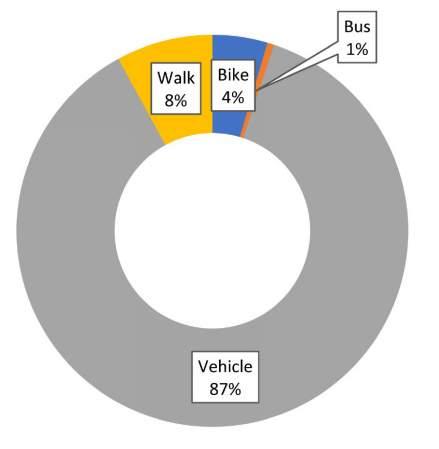
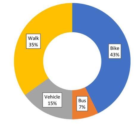
Public involvement for Truman Connected centered on the project’s four phases—Discover, Devise, Distill, Deliver. The effort began during spring 2019 and continued through winter 2020. The project team engaged hundreds of people, including residents, businesses, property owners, visitors, City officials, and others. One of the primary takeaways from the Truman Connected involvement process is that most people drive in Independence today, but most people want to walk or bike more. Additional details on the involvement process are included in the Appendix.
QUESTION:
How do you usually travel in Independence?
QUESTION:
How would you like to travel more often?
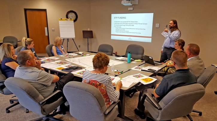
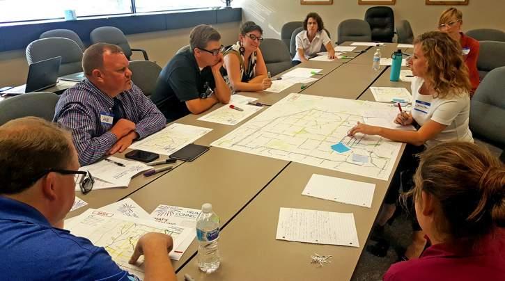
The City, in coordination with the Mid-America Regional Council (MARC), kicked off the Discover Phase with the project’s first Steering Committee Meeting on July 25, 2019 at City Hall. The meeting focused on analysis of existing conditions and hopes for the project. Committee members said equity, access for all ages, transportation choice are essential for improved quality of life, and many residents travel by foot, bicycle, or transit because they lack cars. They said more sidewalks and trails are needed to connect destinations and other pathways. They also discussed their aspirations for creating a memorable bicycle/pedestrian route and said the new path could help boost tourism. This discussion helped establish the vision statement and project goals shown on this page.
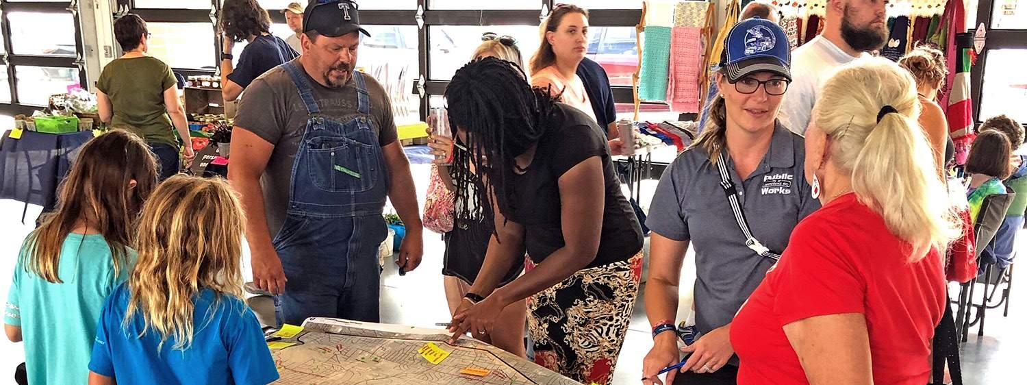
With Committee feedback in mind, the project team held two “pop-up” meetings to gather feedback about preferred routes and destinations for bicycling and walking. The first “pop-up” was held on August 16 during the Englewood Arts Walk. The second was August 17 during the Uptown Market. Over 325 people attended the events and more than 200 commented via the online survey available during the same period. Nearly all expressed a preference for a safe, off-street bicycle/pedestrian path and were excited about the possibility of Truman Connected linking to their favorite places.
The vision statement developed through the inclusive involvement process is as follows:
Specific goals established for this project through the inclusive involvement process include:
• Connect casual pedestrians and cyclists to schools, places of work, and shopping and dining destinations.
• Provide a space for residents to lead healthier lifestyles through active transportation.
• Support existing and new businesses by connecting residents and visitors to them in a fun and attractive way.
• Offer an interactive connection to Independence’s rich history.
• Increase community pride by being aesthetically pleasing and well-maintained.
“The Truman Connected facility will be a safe, inclusive, and aesthetically pleasing space for walking and biking that connects the people of Independence to each other and to the City’s rich history.”
The project team used the feedback and analysis from the Discover Phase to draft a Truman Connected vision statement, project goals, and alignment options. They presented the information to the Steering Committee on September 19 at City Hall. The Committee approved the vision and goals. They also advised the project team to look at north, central, and south segments of Truman Connected that could provide improved access to shopping areas, libraries, and schools in addition to historic sites and Englewood Arts District. Several possible alignment alternates were developed during this meeting.
The Committee said Truman Connected should be developed as part of an overall trail network that connects the broader community and sets the stage for phased implementation in the study area. The project team shared the vision, goals, and alignment options with the broader community via a public open house at City Hall on October 22. Ten (10) people attended and they commented about project funding, existing conditions, and challenges and opportunities related to walking and bicycling in the area.
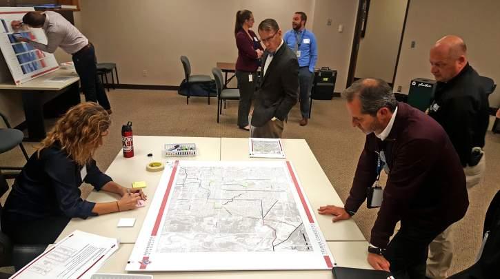
After the Devise phase, two alignment alternates were developed for each of four segments based on the Committee and public feedback. To support the decision-making process of the Steering Committee, a performance matrix was developed showing how each of the alignment alternates aligned with project goals. The alignments explored and the performance matrix are shown on page 13 and 14 of this document. The Committee helped to select a single preferred alignment during the meeting on December 11.
The Committee responded that overall implementation should begin in the north portion of the Truman Connected project area and move south. Phase 1 should connect the Truman Library, Historic Downtown Square, and Englewood Arts District. They said future phases should involve Sterling Avenue and the connection to the Truman Sports Complex. Some were concerned funding constraints and other factors would limit the construction of southern sections.
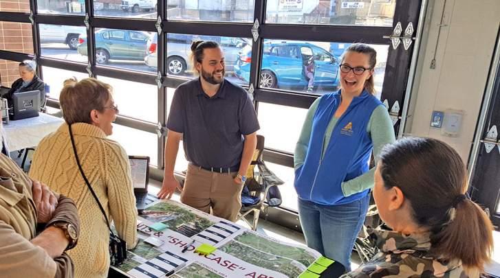
The Steering Committee met for the final time on February 27 at City Hall to review the final route segments for Truman Connected and associated “showcase” areas where enhancements related to history, landscaping, and seating would be located. The Committee indicated that getting the path built was of utmost importance to them. Enhancements should focus on “showcase” areas and could be coordinated with community groups and/or non-profits. The Committee also said coordination with local businesses, such as those in the Lexington Avenue and Englewood Arts District areas, would be important for successful implementation of the project. Additionally, they recommended that the “showcase” areas make the transition from history to art as Truman Connected reaches the arts district.
On March 7, the project team held the last public event for the project—a “pop-up” during the Winter’s Market at the Uptown Market. Nearly 60 people attended. The project team encouraged them to rate each segment of the preferred alignment and “showcase” areas. Participants provided positive feedback and most opted to rate the segments and areas via the project’s latest, online opinion survey. Approximately 240 people commented through the survey, giving the overall route and phasing an average rating of 4.2 stars out of 5. Providing a facility that can be well maintained was a top comment.
A consistent emphasis has been placed on the “four Ts”— Truman, Trails, Transportation, and Tourism—in the City’s previous planning efforts. By implementing a high-quality connected multimodal network that will better serve all roadusers, residents and visitors alike, Truman Connected will serve as a link between the 4T’s in uniquely historical Independence.
The groundwork for this connected multimodal network has been set through recommendations resulting from past development, implementation, and area plans, as well as other documents mentioned in this summary. Stakeholders who participated in previous projects include Jackson County, MO; National Park Service (NPS); Mid-America Regional Council (MARC); Kansas City, MO; Blue Springs, MO and Sugar Creek, MO.
Each previous planning document was reviewed and evaluated in order to determine any applicable policies, plans, or projects that should be considered during the development of the Truman Connected plan. The following section is a summary of the results of that process.
*Please see the appendices for further information on these documents.
• Imagine Independence: Comprehensive Plan 2040 (2018)
• City of Independence Strategic Plan: Independence for All (2017)*
• National Historic Trail Retracement Plan (2018)
• Downtown Streetscape Action Plan (2020)
• Downtown Redevelopment Coordinating Committee Report (2018)*
• Highway 40 Corridor Study and Focus Area Plan (2013)*
• Highway 24 Corridor Study Plan (2006)*
• Englewood Station Arts Circulation Plan (2013)*
• Square Revitalization Plan (2005)*
• Englewood Streetscape Projects (2012-2019)*
• Truman Road Streetscape Projects (2007-2014)*
• 40 Highway Complete Streets Project
• 24 Highway Complete Streets Project
• Sterling Complete Streets Traffic Study (2018)
• Noland Road Complete Street Reconstruction*
• Preservation Master Plan*
• Communities for All Ages
Imagine Independence:
Comprehensive Plan 2040 (2018)
Comprehensive planning is a process that determines goals and aspirations in terms of community development. Its framework guides public policy on transportation, utilities, land use, recreation, housing, and more.
The City and plan contributors share a singular vision for a safe, culturally diverse, family-friendly community with quality neighborhoods, 21st Century jobs, and a growing economy. The comprehensive plan helps guide the City toward its desired future in 2040.
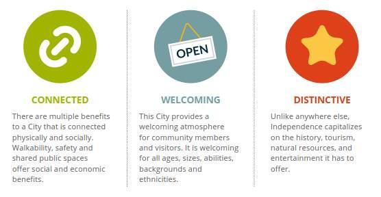
Three themes are used throughout the plan: Connected, Welcoming, and Distinctive. Specifically related to Truman Connected, the plan recommended that the City:
• Design local streets to accommodate pedestrians, bicycles, users of all ages and persons with disabilities.
• Support the convenient and safe multimodal access to jobs and services.
• Promote alternative modes of transportation for non-drivers
• Connect the City’s bike/trail system together and to regional systems such as the Rock Island Trail

• Invest in major corridors with streetscape improvements, public art, green space
• Regardless of mobility level design infrastructure to make moving around the City easier and more convenient”
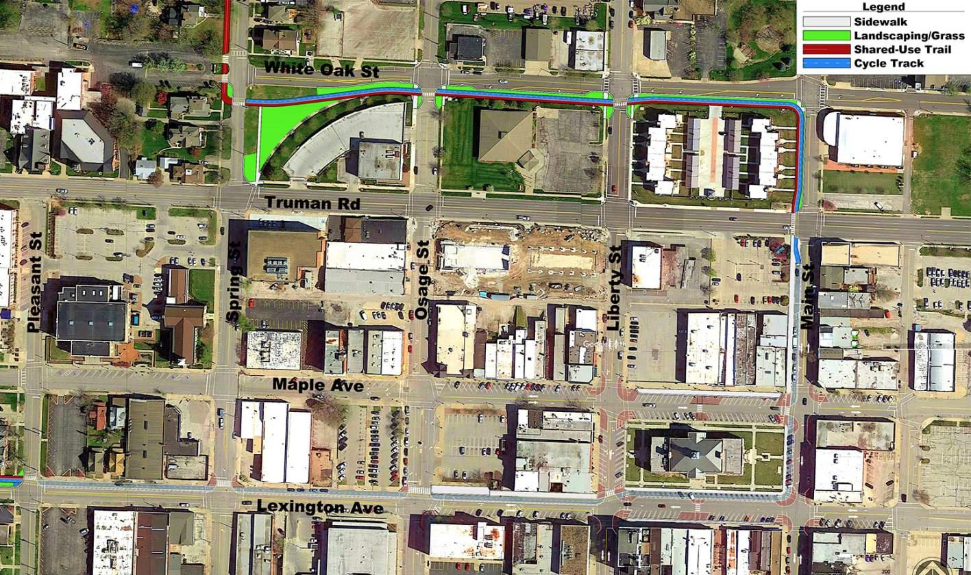
The National Historic Trail Replacement Plan was developed by the National Park Service (NPS) in partnership with the MidAmerica Regional Council (MARC), municipalities, trail associations and others. The primary trail retracement route through Independence is planned to start at the north edge of the city and follow the Mill Creek trail to the Truman Library. At the Truman Library, it crosses under US-24 Highway and follows Bess Truman Parkway, Spring Street, and White Oak Street. From there it passes through the Historic Downtown Square and past the National Historic Trails Museum following Liberty Street and Pacific Avenue to Lexington Street/Crysler Avenue. The route then follows Crysler Avenue to the south.
A study was conducted to determine the operational feasibility of Complete Streets improvements along Sterling Avenue from US 40 Highway to US 24 Highway in Independence. The study considered existing and forecasted traffic volumes, crash history and intersection operations including existing, future no-build and future lane reduction Level of Service (LOS) analyses. The study concluded that Sterling Avenue can function acceptably, except near 23rd Street, where two through lanes per direction will be necessary to avoid additional congestion; north-south protected-permitted phasing should be implemented uniformly at signalized intersections along the corridor; the signals at the 15th Street intersection can be removed; and a roundabout at Sheley Road would provide both operational and safety benefits. The recommended lane reduction for improved safety and operation along the Sterling Avenue corridor involves:
• The reconfiguration of Sterling Avenue to provide one through lane in each direction, plus a center left-turn lane throughout its length.
• Adjustments to signal timing plans and implementation of protected-permitted left turn phasing.
• Lowered speed limit based upon the final design/configuration.
• Enhanced/additional pedestrian treatments
The Downtown Streetscape Action Plan was initiated during the Truman Connected PSP project process to address additional concerns and to chart a path forward to quick implementation of streetscape improvements envisioned on the Downtown Square. The plan contains specific recommendations for improvements to the streets and sidewalks on the square, including how Truman Connected can best be incorporated into the Square area.
The multi-phase 24 Highway Complete Streets project includes improvements along US 24 Highway in Independence. The project, included in the City’s 20202026 Capital Improvements Program (CIP), is a continuation of 24 Highway improvements, and a commitment from the Council outlined in the City’s Strategic Plan to improve corridors. The City has partnered with the Missouri Department of Transportation to design construct these improvements through the utilization of Federal grant, State Cost Share, State Safety, and local transportation funds.
Ultimately, the City and MoDOT identified funding to support improvements along US 24 Highway from 291 Highway to Wilson Road in the Fairmount District. Improvements include a multi-use trail on one side of US 24 Highway, with a sidewalk on the other, and a center left-turn lane along US 24. At the existing signalized intersections, it is projected that existing signal infrastructure will be replaced to include accessible pedestrian signals and right turn lanes added as warranted.
The multi-phase 40 Highway Complete Streets project includes improvements along US 40 Highway in Independence. The project, included in the city’s 2020-2026 Capital Improvements Program (CIP), is a continuation of 40 Highway improvements, and a commitment from the Council outlined in the City’s Strategic Plan to improve corridors.
The Kansas City metropolitan area’s older adult population is expected to nearly double over the next 20 years from almost 219,000 people in 2010 in the nine metro counties to over 416,000 by 2030, a 90 percent increase. KC Communities for All Ages, an initiative of the Mid-America Regional Council (MARC), was formed in 2008 to coordinate a community response to the future needs of this coming “age wave” by helping to focus leadership on increasing the region’s capacity in the areas of housing, transportation and mobility, social and civic engagement, caregiving, health care and public education.
Phase I focuses on improvements along the north side of US 40 Highway from Blue Ridge Cutoff to Sterling Avenue. Improvements include major consolidation and reconstruction of existing driveways and construction of 5-foot to 6-foot wide Americans with Disabilities Act (ADA)-compliant sidewalks along the north side of the road. A westbound 5-foot wide buffered bike lane will also be constructed.
The City plans to continue these same improvements along the south side of US 40 Highway from Blue Ridge to Sterling as a second phase.
Urban shared use paths and mixed-mode bicycle networks are incredibly important for neighborhoods. In particular, urban trails can result in better health outcomes due to physical activity. They also provide economic benefits, such as revitalization activities and increased property values. Further, they offer additional mobility options, opportunities to build stronger community relationships, reduced pollution, and safer environments for all.
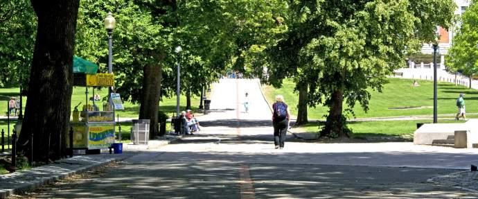
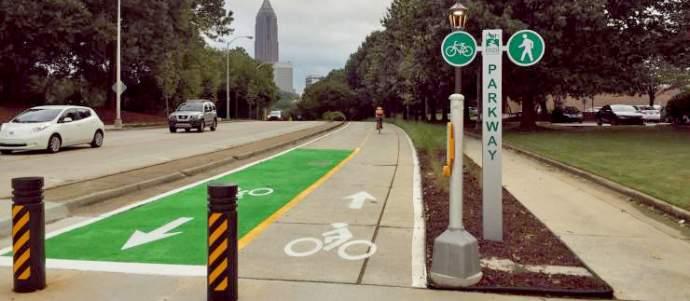
To better understand potential impacts, the team considered a number of case studies that are relevant to the Truman Connected project, primarily due to their scale, neighborhood geography, and intended connection to cultural and historic assets and amenities. These case studies included:
• Indianapolis Cultural Trail; Indianapolis, IN
• Freedom Trail; Boston, MA
• Atlanta BeltLine; Atlanta, GA
• Beerline Trail; Milwaukee, WI
• Bloomingdale Trail; Chicago, IL
With over 4 million annual users, the 2.5-mile Freedom Trail connects 16 nationally significant historic sites in Boston which includes a unique collection of museums, churches, meeting houses, burying grounds, parks, a ship, and historic markers that tell the story of the American Revolution and beyond. Although the total implementation cost are difficult to define due to the amount of independent projects and funding partners, the Freedom Trail Foundation estimates that the trail generates over $1B in spending, and helps create jobs in hospitality, education, and tourism.
For further information see: https://www.thefreedomtrail.org/
Beerline Trail is a 3.7-mile city-to-county, urban trail located along the western side of the Milwaukee River connecting from Pleasant Street, just north of Downtown Milwaukee, through Gordon Park and the Riverwest neighborhoods following the path of an old railroad line and connecting a number of historic brewery sites and buildings. At approximately $4M in current implementation costs, the greenway is estimated to have resulted in over $7M in trail-adjacent real estate projects. A 67-mile extension, the ARTery, was completed in 2015 and intended to focus on cultural diversity.
For further information see: https://city.milwaukee.gov
At a total estimated implementation cost of $63 million, the Indianapolis Cultural Trail is an internationally-acclaimed 8-mile biking and walking trail connecting all six of Indy’s Cultural Districts, including Massachusetts Avenue, Fountain Square, The Canal & White River State Park, Indiana Avenue, the Wholesale District, and Broad Ripple. The latest economic impact report indicates that properties within1/8mile of the trail increased 148% since 2008 resulting in $1B increase in assessed property value with over 1 million users per year.
For further information see: https://indyculturaltrail.org/
Estimated at $3.5M in implementation cost, the PATH Parkway project is a 1.5-mile tree-lined walking and biking facility connecting West Midtown, Georgia Tech, and the Coca-Cola Headquarters to Centennial Olympic Park. The new facility features safe, separated bicycle infrastructure linking the John Portman protected bike lanes, the Stone Mountain Trail, the Atlanta BeltLine Eastside trail and other essential bicycle infrastructure within the City.
For further information see: https://pathfoundation.org/
A 2.7-mile urban mixed-use trail developed on the abandoned Bloomington Line that connects to four of Chicago’s most culturallydiverse neighborhoods while connecting to open space, transit, and other amenities such as public art and an observatory. As part of the $95M 606 Project on Chicago’s northwest side that will serve 80,000 neighbors, the Bloomington Trail portion of the trail system has an estimated 3,500 daily users and is associated with an almost 350% increase in real estate values for some areas along its route.

For further information see: https://www.bloomingdaletrail.org/
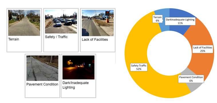
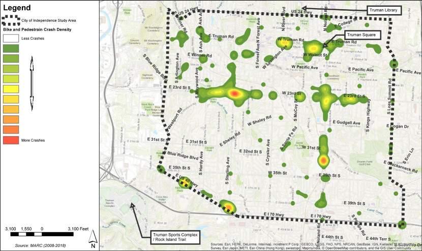
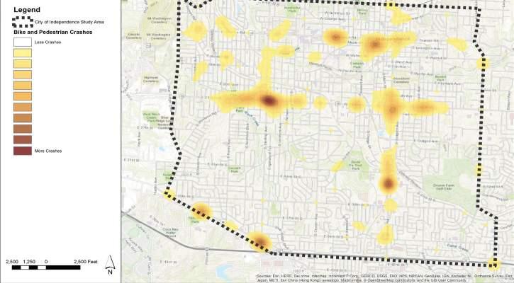
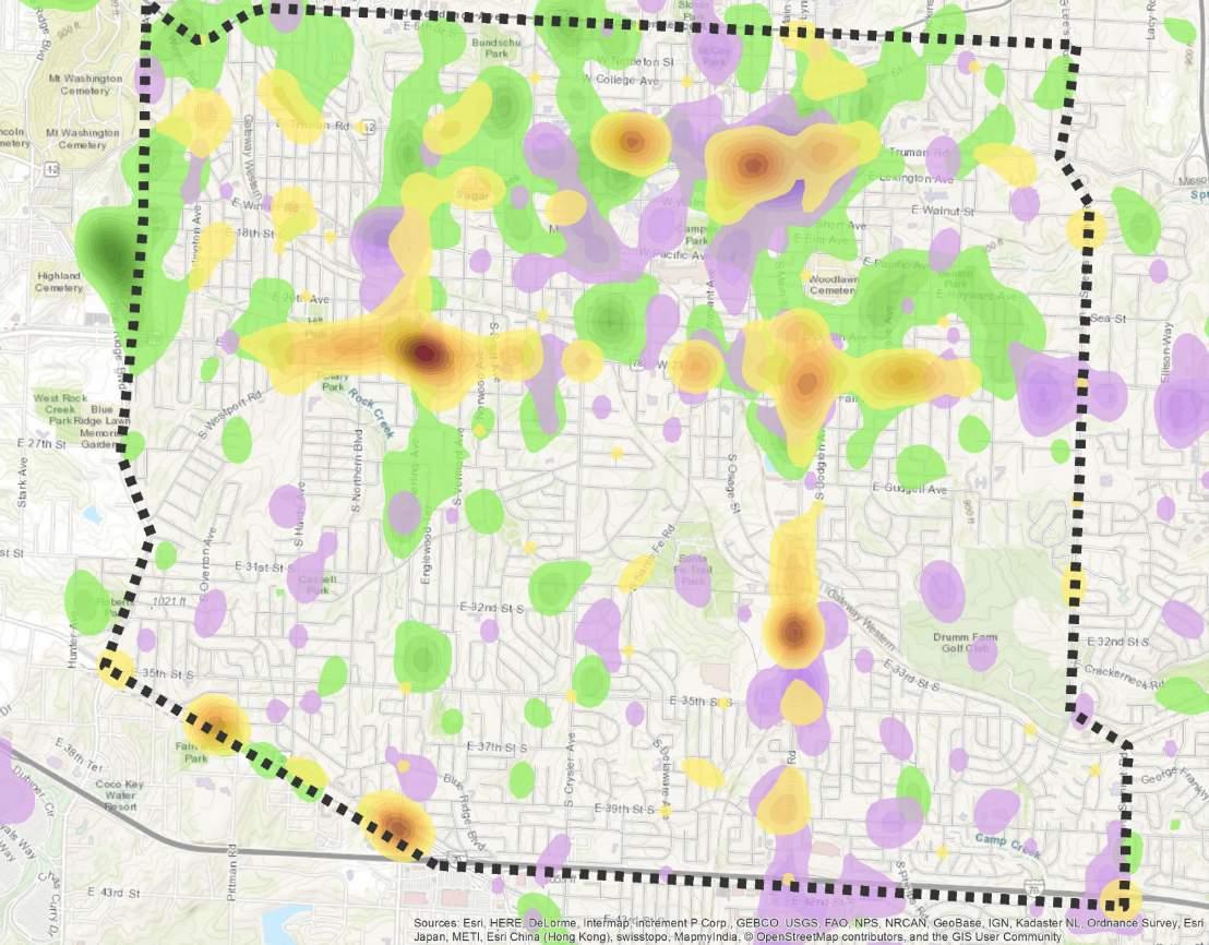
Traffic crashes are a major source of physical and financial suffering for residents of Independence. This map shows the hotspots where a high density of traffic crashes involving cyclists or pedestrians have occurred in Independence. The highest concentration of bicycle & pedestrian crashes occurred along the 23rd Street, Noland Road, 40 Highway, and around the Square.
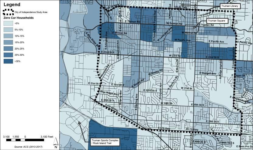
The planning of the Truman Connected facility is based on a data-driven approach. As part of the project, the team assembled data on existing conditions and compiled it using GIS mapping. The data was collected from the City of Independence, the Mid-America Regional Council, and the US Census Bureau. This data was mapped to show different areas of needs, trends, and physical characteristics in the Truman Connected project area. The data was then aggregated to create facility demand maps.
These maps show areas in Independence where a Truman Connected facility could best serve the goals of the project. This data was presented to the public and the steering committee throughout the process and helped guide the decision making on the route alignment and facility type selection. The following maps highlight the relevant demographic data, street feature data, and bicycle/ pedestrian crash data in the study area.
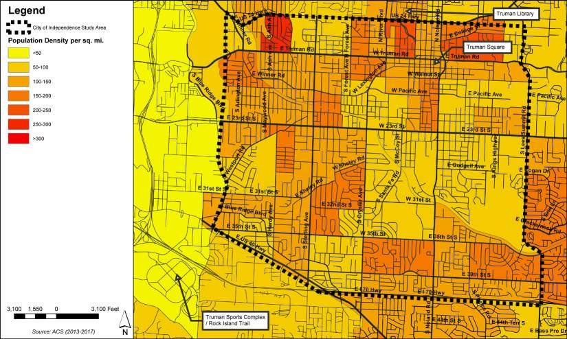
The ultimate Truman Connected alignment that has been chosen in this plan is shown on these maps for reference. It can be seen that the alignment follows areas with greater need or greater connectivity to existing sidewalks or are along transit routes.
This map shows the areas in the city that have more households without vehicles. Connectivity to transit and safe walking and biking facilities are generally desired in areas without car accessibility.
Generally, Independence is built with a low population density with most residents living in single family homes. However, there are some areas with higher density, notably around the Square, near the Englewood Station Arts District, and along Sterling Avenue.
Understanding property values provides insight into the social and economic status of the community that will be served by the project. The areas of lower property value correspond to locations where the facility could potentially improve property values, increase revenues, and enhance quality of life for the community.

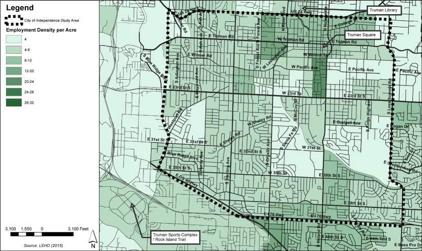
There is a large employment center in historic downtown Independence. Other areas in the city that have a larger area of employment are shown to better understand where people might need to connect to work.
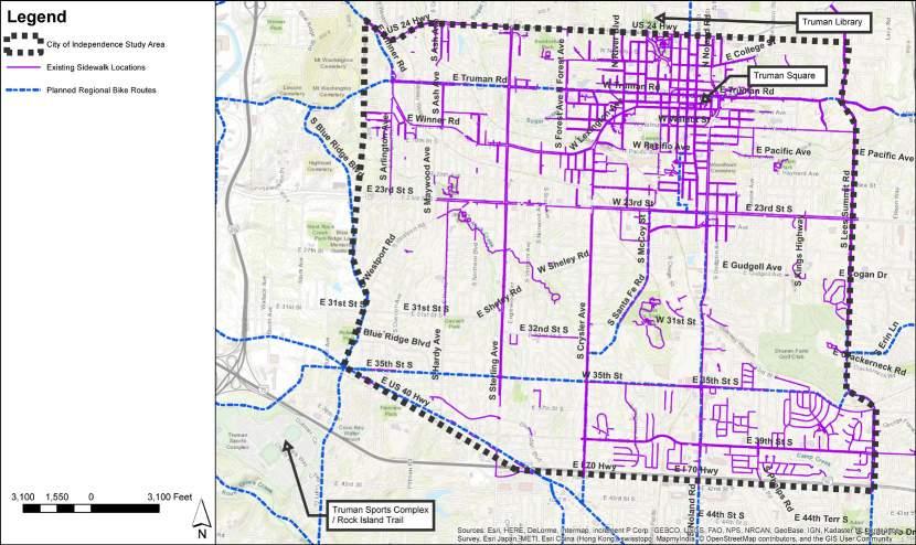
Pedestrian infrastructure exists in and around the Square. Beyond this area, sidewalks and trails are rare. A few high quality trails exist in the city including the Rock Creek Trail, and Santa Fe Park Trail.
There is transit connectivity north/ south and east/west in Independence. The transit routes all come together at the Square and connect the major destinations in the area and in the greater region. A major transit center exists just north of the Square at Truman & Noland providing transit access to the greater Kansas City Metro area.

The data from the existing conditions maps, crashes, and online survey was combined to create maps showing areas of higher demand for a Truman Connected facility. Each of the following maps shows a different metric, and then all the metrics combined. On the heatmap, where the color is darker, it indicates a higher demand area. These higher demand areas show where the need is greatest for a Truman Connected facility.
The ultimate Truman Connected alignment in this plan is shown on these maps for reference. It can be seen that the alignment passes through areas with greater need or greater demand.
This map combines the various demand metrics. It shows that the highest demand corridors and areas located between the Downtown Square and the Englewood Station Arts District. Other areas with a high demand for a Truman Connected facility are along Truman Road, Sterling Avenue, US-40 Highway, 23rd Street and Noland Road.
This map shows where pedestrians or cyclists have been most often hit by cars in the past 10 years. This shows us where people are walking/biking today, and where the greatest danger is. Truman Connected has the potential to improve safety in these areas.
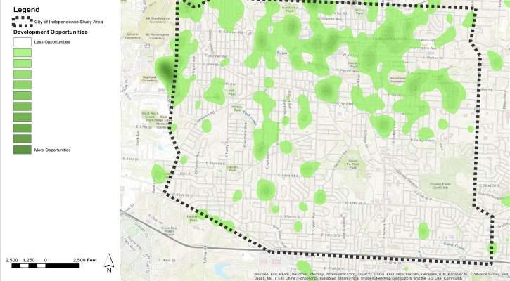
This map shows locations where the greatest opportunity for land development could occur. Locations included in this data set are vacant lots and underutilized land. Truman Connected has the potential to catalyze economic development in these areas.
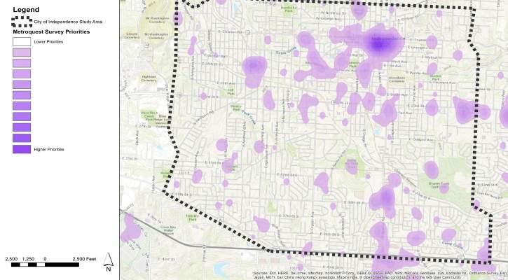
This map shows where the public indicated they would like to see a Truman Connected facility. This data was a combination of where people said they would want to access using the facility, combined with their preference for what type of location is a higher or lower priority. The public saw work/school as the highest priority location, followed by shopping/dining, and recreation/parks.
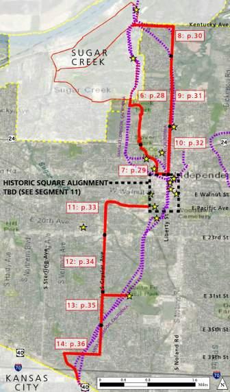
After gathering feedback from the public and Steering Committee on potential routes to connect the primary destinations (the Truman Library, the Downtown Square, and the Truman Sports Complex/Rock Island Trail), a number of potential routes were analyzed for the Truman Connected route. Four primary segments were determined for analysis:
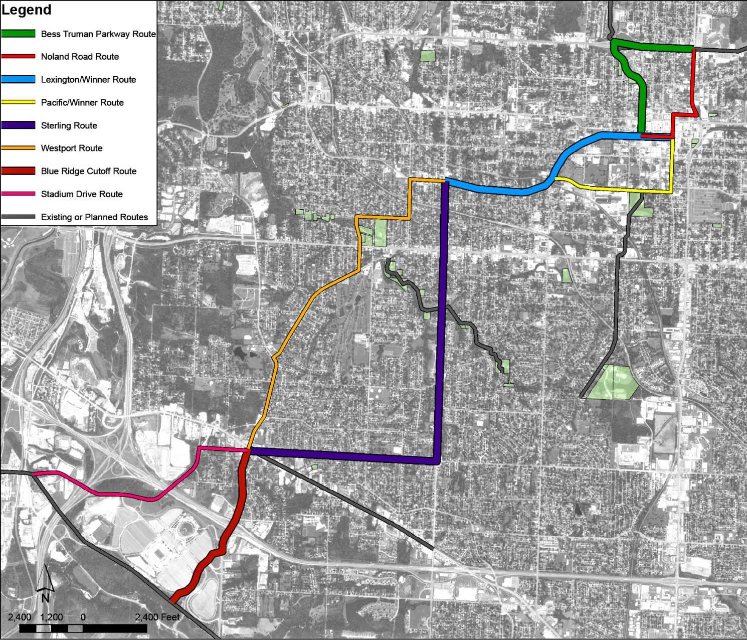
• Square North (Truman Library to the Downtown Square)
• Square South (Downtown Square to the Englewood Station Arts District)
• Central City (Englewood Station Arts District to US-40 Highway)
• Rock Island Connector (US-40 Highway to Truman Sports Complex/Rock Island Trail)
For each of these segments, two primary alignment options were developed. Those alignment options can be seen in the adjacent map. Scoring criteria were applied to each of these options based on the project vision and goals and a performance matrix was developed (as shown on page 14). This performance matrix helped the decision-making process by the public, Steering Committee, and City staff to determine the final general alignments. These final general alignments were:
• Square North (Truman Library to the Downtown Square
> Utilize Bess Truman Parkway and Spring Street
• Square South (Downtown Square to the Englewood Station Arts District)
> Utilize Lexington Avenue and Winner Road
• Central City (Englewood Station Arts District to US-40 Highway
> Utilize Sterling Avenue & US-40 Highway
• Rock Island Connector (US-40 Highway to Truman Sports Complex/Rock Island Trail)
> Utilize Blue Ridge Cutoff
It should also be noted that the secondary alignments for each of these sections had their own merits. They remain in the plan for future facility implementation after the primary phases of the Truman Connected project are complete.
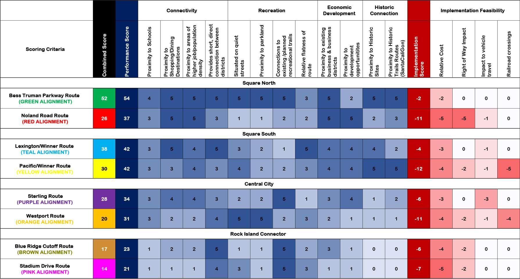
The general routes and segments selected in partnership with the public, the Steering Committee and City Staff were further refined based on engineering analysis and feasibility along individual streets. A priority for the routes was also determined by the Steering Committee. Based on preliminary cost estimates, available construction budgets, and segment priority, the initial project phasing was determined.
The map to the left shows the final recommended Truman Connected alignment and phasing. As noted in the section of this plan detailing the Evaluation of Potential Routes, there were a number of possibilities for the Truman Connected facility. The routes chosen were based on the majority of the feedback from the public, the Steering Committee, elected officials, and identified as the highest scoring routes in the data-driven analysis of this plan.
Throughout the public engagement process, the project team consistently heard a desire for facilities to also be placed on Pacific Avenue (to connect to the National Frontier Trails Museum and the Truman Depot), and along Westport Road (because it currently serves as a popular cycling route). The scoring matrix showed
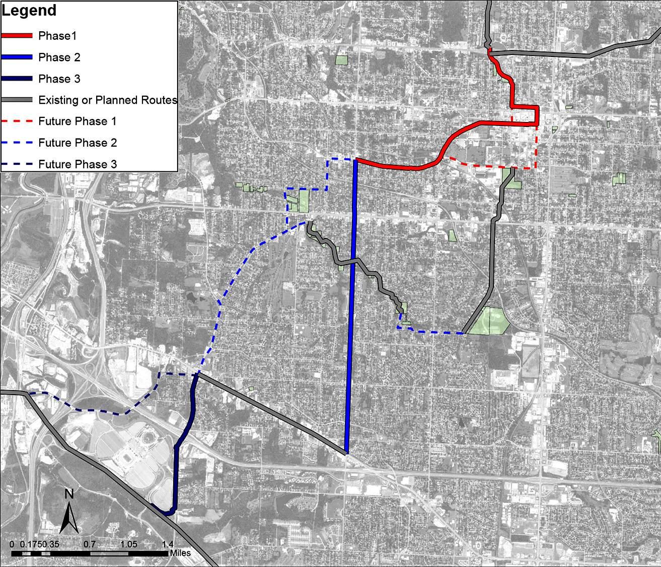
these two routes as having good performance, but not as strong as the selected routes. For these reasons, these alternate routes have been included in the plan as future phases. In addition to the Pacific Avenue and Westport Road routes, a short connection has been identified between the Rock Creek trail and the Santa Fe Trail. These future phases will provide good expanded connectivity to the Truman Connected facility and provide several loop routes for recreational use.
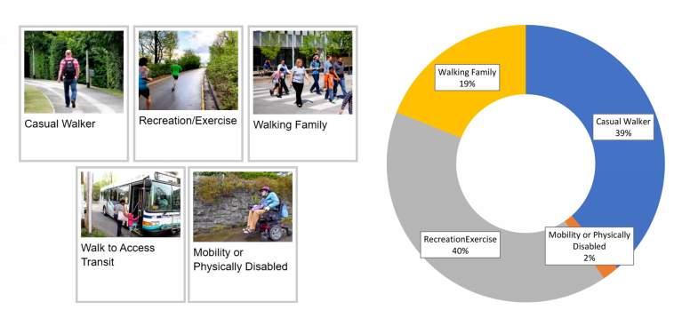
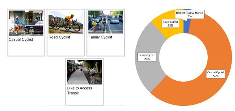
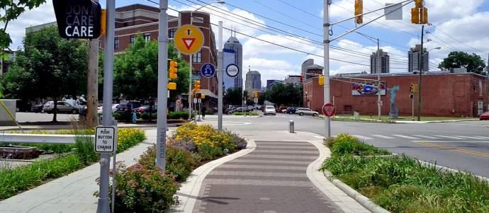
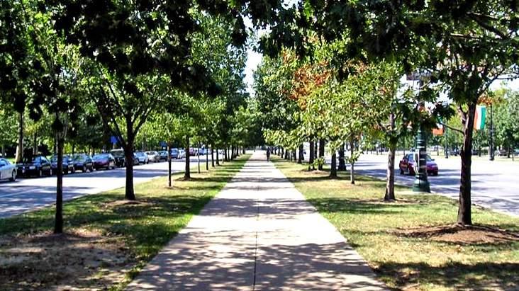
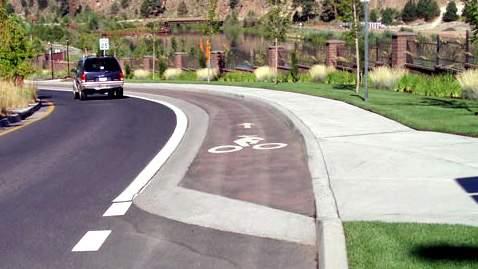
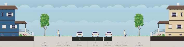
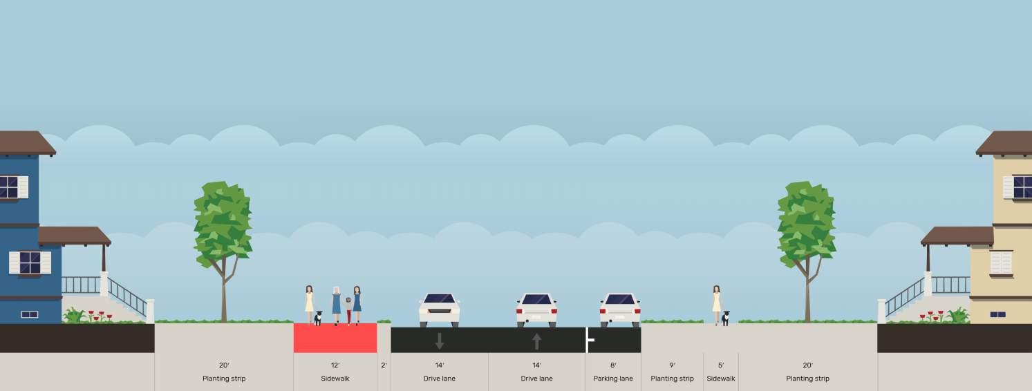
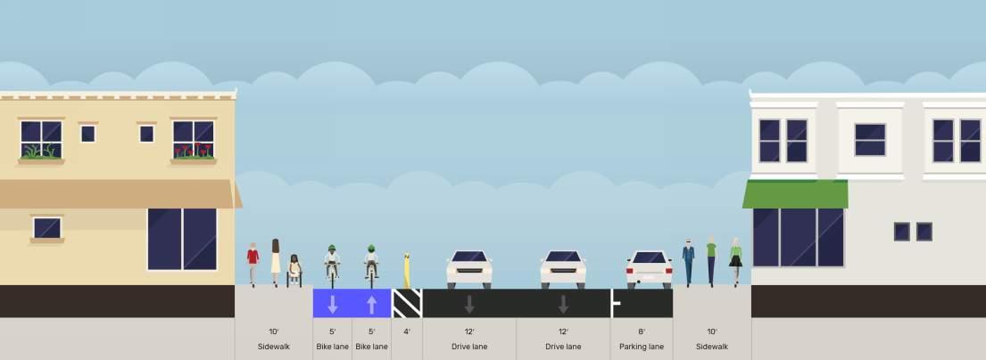
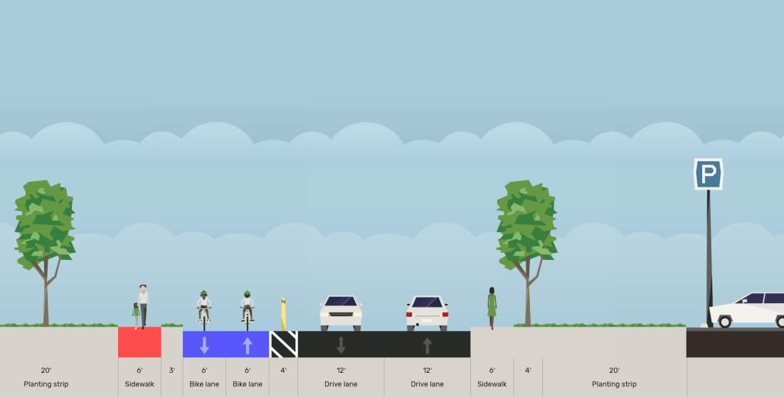
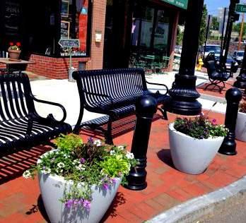
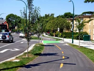
The initial public outreach included questions as to what type of facility was desired for Truman Connected. The primary responses to the question highlighted the facility shown in the adjacent pictures to be the preferred facility types.
The steering committee also expressed a desire to separate faster and slower modes of transportation wherever possible to avoid bicycle-pedestrian or e-scooter-pedestrian conflicts. This led to the idea of including a mobility track adjacent to the pedestrian path. The mobility track would be used for higher speed users (higher speed cyclists, scooter users, etc.). The pedestrian path would be used by slower speed users (pedestrians, children on bicycles, wheelchair users, etc.).
In some more constrained locations, all users would occupy the same space on a shared-use trail which would require faster moving traffic to yield to slower moving traffic. Informational signage will be utilized as necessary along the route to indicate the proper and safe use of the facilities. Based on this input, three primary segment types were determined in the concept development:
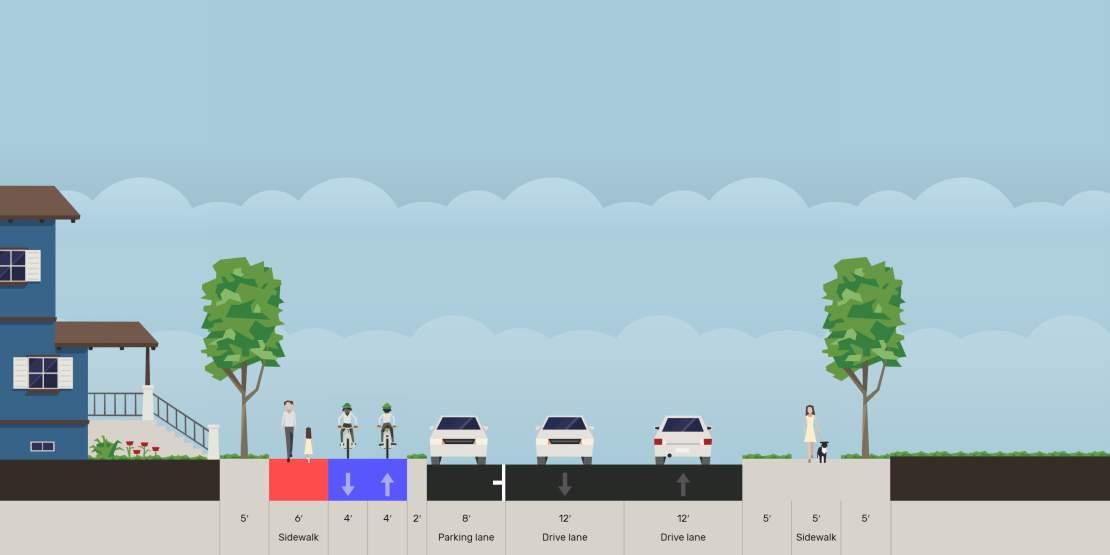
• Shared-Use Trail: Where right-of-way was constrained along the route, or where the facility was being constructed through primarily residential areas, the concept of a shared-use trail is recommended.
• Pedestrian Path and Separated Mobility Track: In areas where the right-of-way is less constrained, the concept of a mobility track (for higher speed bicyclists, e-scooter riders, or other users) is included separate from the pedestrian path.
• Pedestrian Path and Adjacent Mobility Track: Through the Downtown Square, the mobility track (for higher speed bicyclists, e-scooter riders, or other users) is included adjacent to the existing sidewalks. The project team and steering committee felt that the existing historical sidewalks should remain as they currently exist, but that the continuous mobility track was important as well.
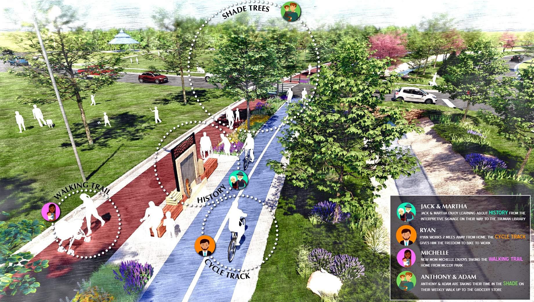
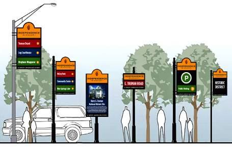
To further the recognition of Truman Connected as a cohesive, continuous, and branded facility it was determined that color-coding of the facility paving would be desirable. To this end, the shared-use trails and pedestrian paths areas are envisioned with a red tinted pavement, and the mobility track as blue tinted pavement. The color-coding will help users identify the facilities as unique and branded spaces, to help with route wayfinding, and to indicate the spaces where fast speed users such as cyclists need to yield to lower speed users such as pedestrians. In addition to the color-coding, signing will be posted throughout to indicate user priority/designated use spaces, wayfinding, and branding. This is reflected in the detailed concept plan and the renderings of the showcase areas.
The following maps detail the concept plan for the first phase of Truman Connected implementation. This phase includes the section from the Truman Library to the Downtown Square, and from the Downtown Square to the Englewood Station Arts District. As noted before, the shared-use trails and pedestrian paths included in this concept plan are envisioned with a red tinted pavement, and the mobility track as blue tinted pavement.
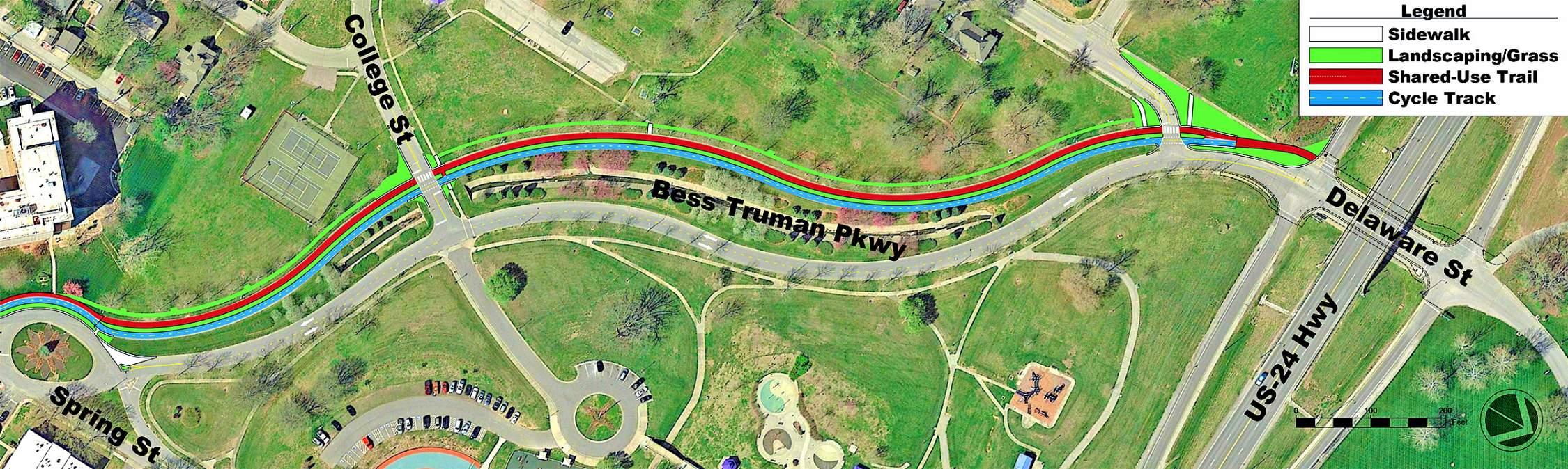
This segment runs from the US-24 bridge to Spring Street. The US-24 bridge is currently being reconstructed with a 10’ trail + a 5’ sidewalk and wide shoulders for biking & walking and will connect into the McCoy trail north of the highway. Truman Connected will connect to these new improvements, then utilize the existing pavement of the southbound lanes (west side of road) of Bess Truman. Two-way car traffic will use what is currently the northbound lanes (east side of road). The center of the southbound lanes will be cut out to allow for landscaping and other amenities in that zone.
Respondents to the final online survey were asked to rate the concept plan for this segment. This was the rating given to this segment.
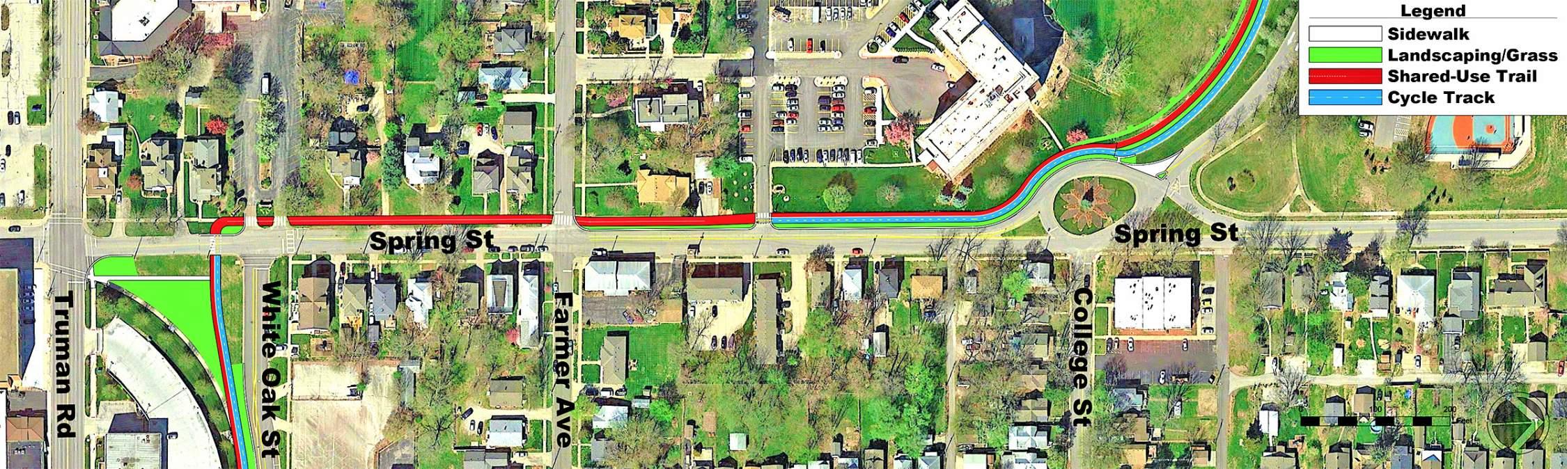
This segment connects from Bess Truman to White Oak along Spring Street. Because this is a residential street, the narrower shared-use trail concept was used in front of the private residences. The street is narrowed somewhat on the north end; existing street width is maintained the same on the south end. Where the facility is adjacent to private residences, the outside edge (yard site) of the shared-use trail would be in the same location as the existing outside edge (yard side) of the existing sidewalk.
Respondents to the final online survey were asked to rate the concept plan for this segment. This was the rating given to this segment.
Downtown Square Area
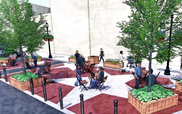
This section follows along White Oak Street and then Main Street and Lexington Avenue through the Downtown Square. The segment on White Oak includes a two-way mobility track adjacent to a new sidewalk. The diagonal street connection going northeast from the Truman Road & Spring Street intersection is eliminated, which opens up a large public space. Members of the public expressed interest in using this space for a dog park for residents of the Downtown Square. Through the Downtown Square, the mobility track is continued in the street (separated by a painted buffer and bollards), and the sidewalk is planned to remain as is (aside from sidewalk reconstruction to address maintenance needs). The area surrounding the Courthouse is shown to reflect the improvements planned in the Downtown Streetscape Action Plan. These improvements will be implemented separately from Truman Connected, but will integrate with the Truman Connected facilities. The Truman Connected improvements shown here will result in a minor loss of parking along Main Street and Lexington Avenue. However, the Steering Committee felt that adequate parking supply would still exist around the Square with these changes.

4.0 / 5
Respondents to the final online survey were asked to rate the concept plan for this segment. This was the rating given to this segment.
Lexington Area: Plan Rendering along Lexington Avenue from Pleasant Avenue to River Boulevard
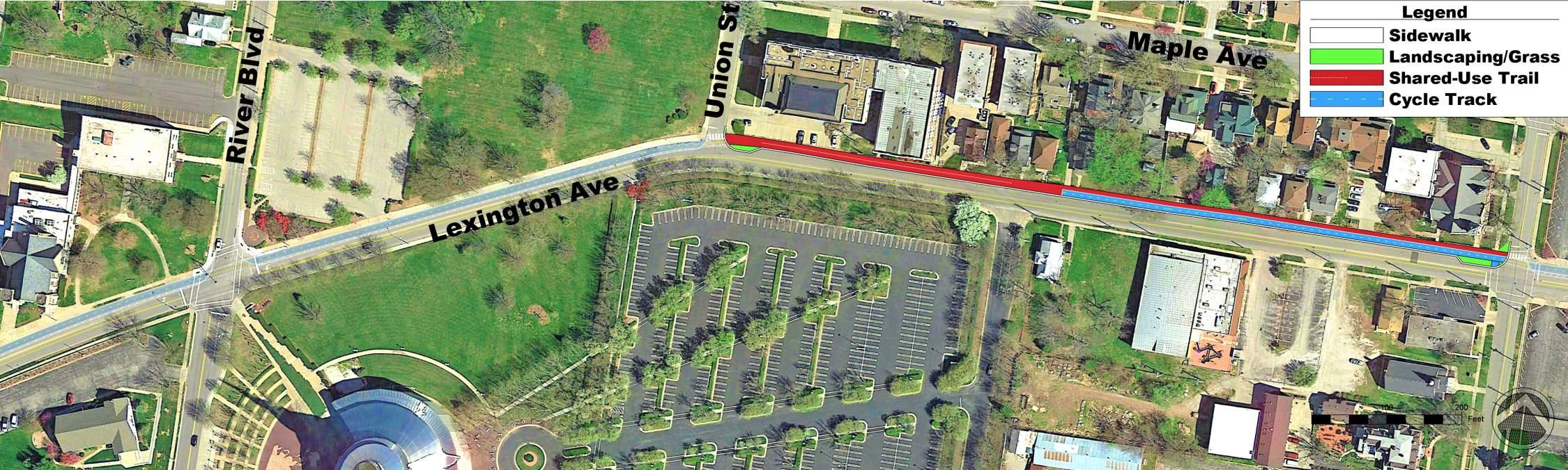
Lexington Area
This segment extends from the Downtown Square to the west following Lexington Avenue. The vehicle lanes are narrowed to a more typical width to allow for construction of the facility, and on-street parking is maintained where it is currently being utilized east of Union Street. The eastern portion of the facility maintains the mobility track and adjacent sidewalk concept separated from the street lanes for cars.
Where the street space is constrained closer to Union Street, the facility is narrowed to the shared-use trail concept layout. Where the facility is adjacent to private residences, the outside edge (yard side) of the shared-use trail would be in the same location as the existing outside edge (yard side) of the existing sidewalk.
West of Union Street, the facility is planned as a mobility track in the street (separated by a painted buffer and bollards), and the sidewalk is planned to remain as is. This decision was made to reduce cost on the project to fit within existing Phase 1 funding.
3.9 / 5
Respondents to the final online survey were asked to rate the concept plan for this segment. This was the rating given to this segment.
This section extends the rest of the way on Lexington Avenue to Crysler Avenue. The concept remains the same to install the mobility track in the street (separated by paint and bollards from traffic) and narrow the car lane widths to a more typical width. At the Walnut Street signal, the mobility track is terminated and combined with the pedestrians in a shared-use trail segment to accommodate traffic signal operations and fit within right of way constraints. The old bridge over the railroad tracks at the intersection of Lexington Avenue, Crysler Avenue, and Winner Road will be converted to be bicycle & pedestrian only. Cars will utilize the intersection at Winner Road and Crysler Avenue to make southbound right turns as at a typical intersection. This opens up the ability for a large amount of public space for an art installation or historical interpretation. This section will also connect to the Pacific Avenue Trail, which is currently scheduled for 2020 construction. By connecting to this spur, residents and visitors will gain direct access to the Historic Truman Depot, the National Historic Frontier Trails Museum, and the Bingham-Waggonner Home.
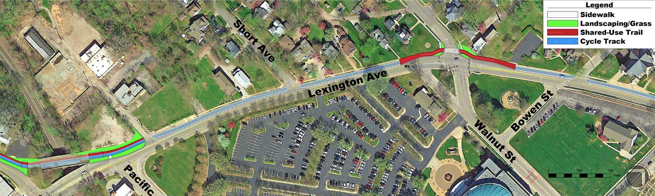
3.9 / 5
Respondents to the final online survey were asked to rate the concept plan for this segment. This was the rating given to this segment.
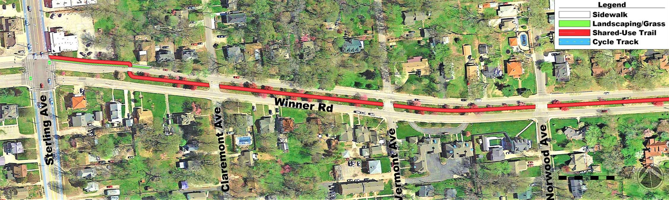
The eastern half of Winner Road from Crysler Avenue/Lexington Avenue will utilize the mobility track and sidewalk concept separated from traffic on the north side of the road. The existing sidewalks will be retained on both sides of the roadway.
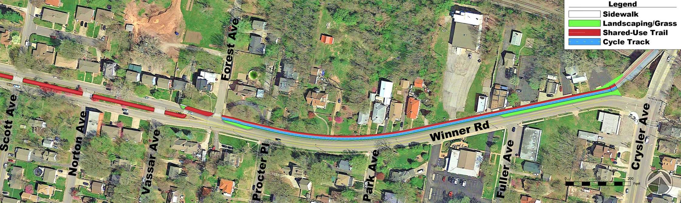
At Forest Avenue the track will narrow to a shared-use trail and cross over into the wide landscaped median. The decision to place the trail in the median was made to avoid the need for eliminating the parking for residents on Winner Road, maintain the existing sidewalks for direct access from the parking to the residences, and provide a attractive landscaped median trail in a manner similar to what residents indicated as a preferred facility type in the online survey. High visibility crossings will also be used to ensure safe crossing at side streets and into the center median.
3.9 / 5
Respondents to the final online survey were asked to rate the concept plan for this segment. This was the rating given to this segment.
4.2 / 5
Respondents to the final online survey were asked to rate the concept plan for this segment. This was the rating given to this segment.
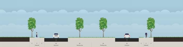
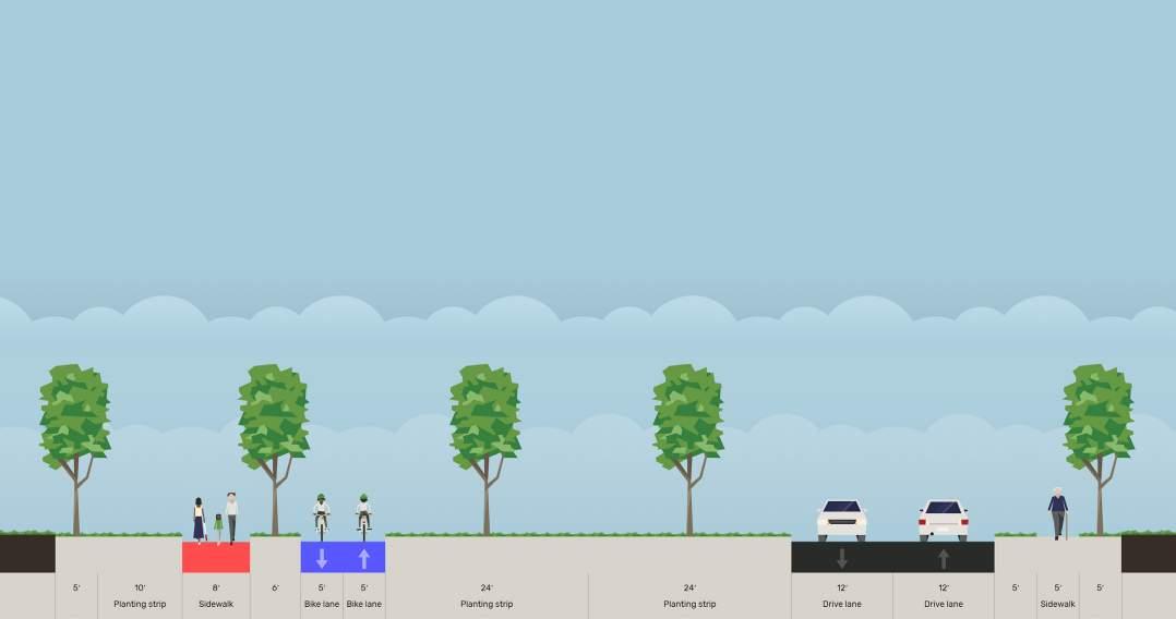
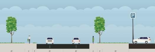
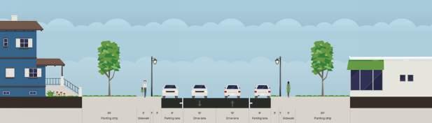
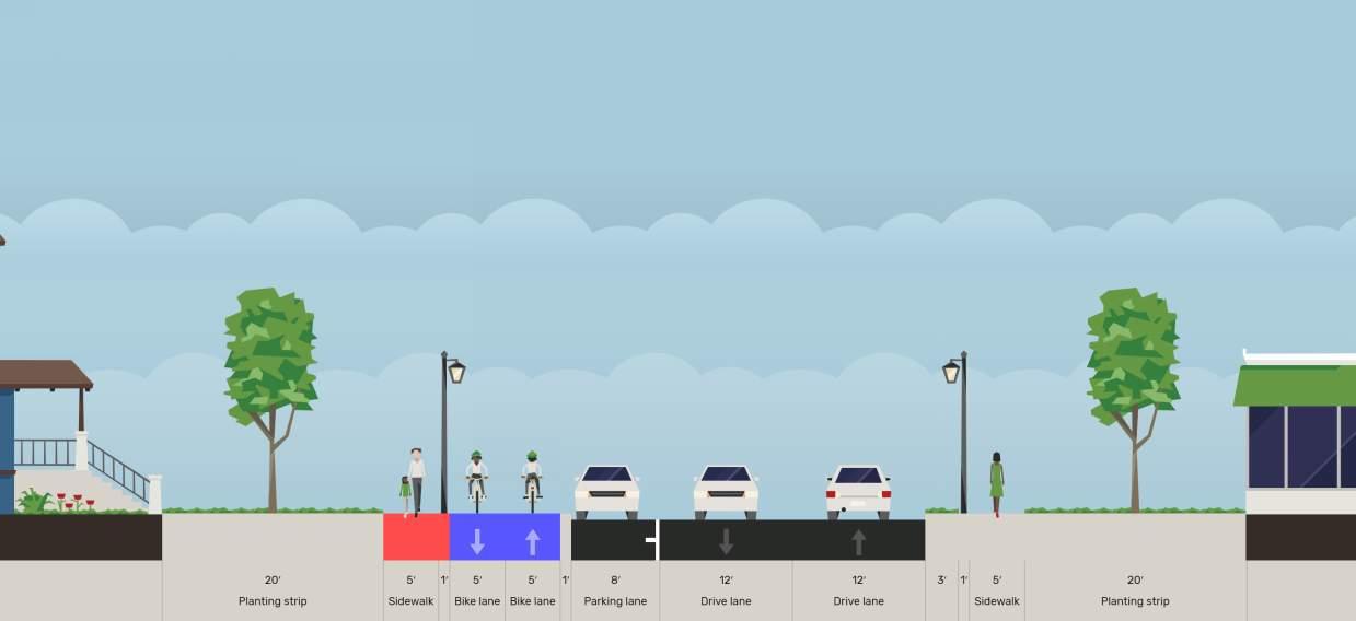
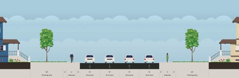
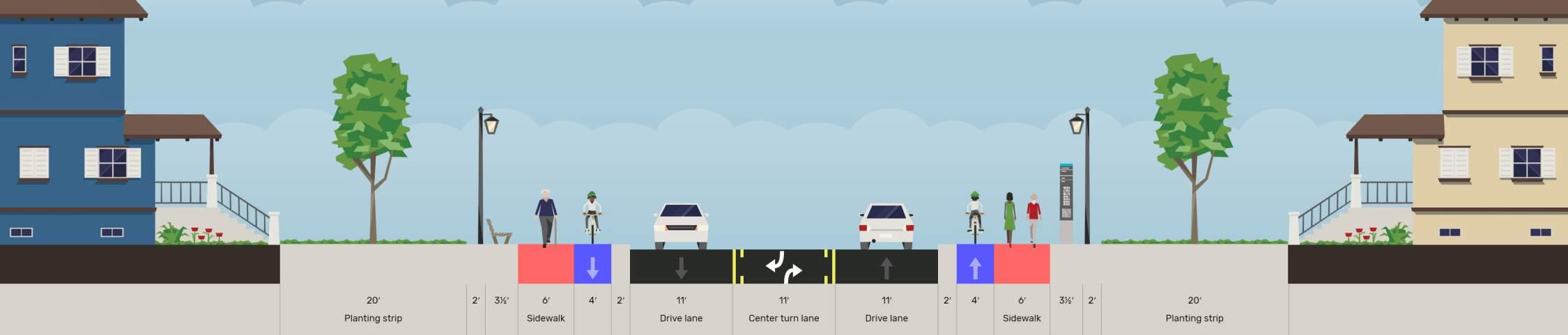
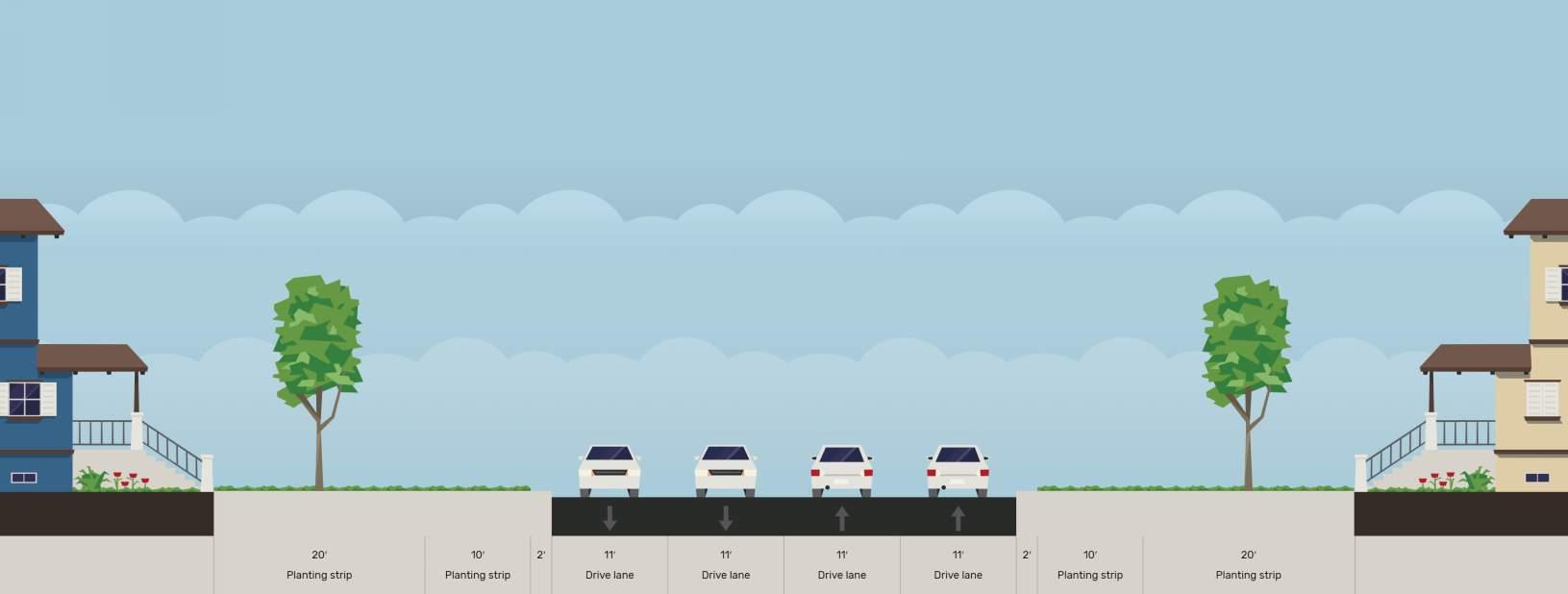
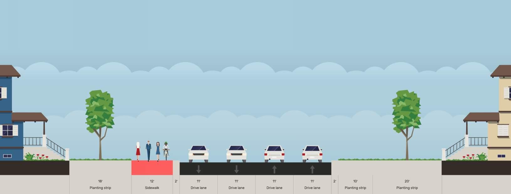
Phase 2 of Truman Connected on Sterling Avenue from Winner Road to US-40 Highway is envisioned as shown in the adjacent crosssection. This section is similar to one of the preferred facility types selected by the public. The cross section envisions an enhanced bicycle and pedestrian facility on both sides of the roadway. Because of the challenges with the many traffic signals and right-of-way width limitations, it is not feasible to provide a wide facility on just one side of the road as the Phase 1 facility and Phase 3 facilities are envisioned.
To achieve this vision, a lane reduction of 1-lane in each direction will be needed. This would result in converting the road from 2-lanes in each direction with no center turn lane/median to a road with 1-lane in each direction and a continuous left-turn lane/ median (also referred to as a “3-lane” road). This conversion was studied from a traffic congestion perspective in a traffic study (included in the appendix to this plan) and found that the street would perform to a similar level with 3-lanes as it would with 4-lanes. The conversion would also likely result in a reduction in crashes overall. The Federal Highway Administration has found1 that this type of conversion from a 4-lane road to a 3-lane road has the potential to reduce traffic crashes overall by 20% - 50%.

Footnotes:
1https://safety.fhwa.dot.gov/provencountermeasures/road_diets/
The cross-section images on the following pages show both an interim and ultimate improvement configuration. Throughout the planning process, the steering committee and public expressed a desire to construct economical improvements that can be quickly implemented. The interim improvement configuration could be constructed for a lower cost and be completed more quickly because the existing pavement is utilized for the bicycle facilities. The ultimate improvement configuration will provide a higher quality experience for the users but cost more to construct. By providing these two alternatives, it will be possible to more quickly and less expensively construct the interim improvements while planning for implementation of the future improvements at a later date when funding is available. The rendering on the following page depicts the vision of the ultimate improvements.
Phase 3 of Truman Connected runs along Blue Ridge Cutoff from US-40 Highway to the Rock Island Trailhead just south of the Truman Sports Complex. This section would consist of a shareduse trail on the west side of Blue Ridge Cutoff and be designed similar to the shared-use trail included in Phase 1. Phase 2 and 3 would connect on US-40 Highway by way of the trail planned on that segment with the US-40 Highway reconstruction project planned to start in 2020.
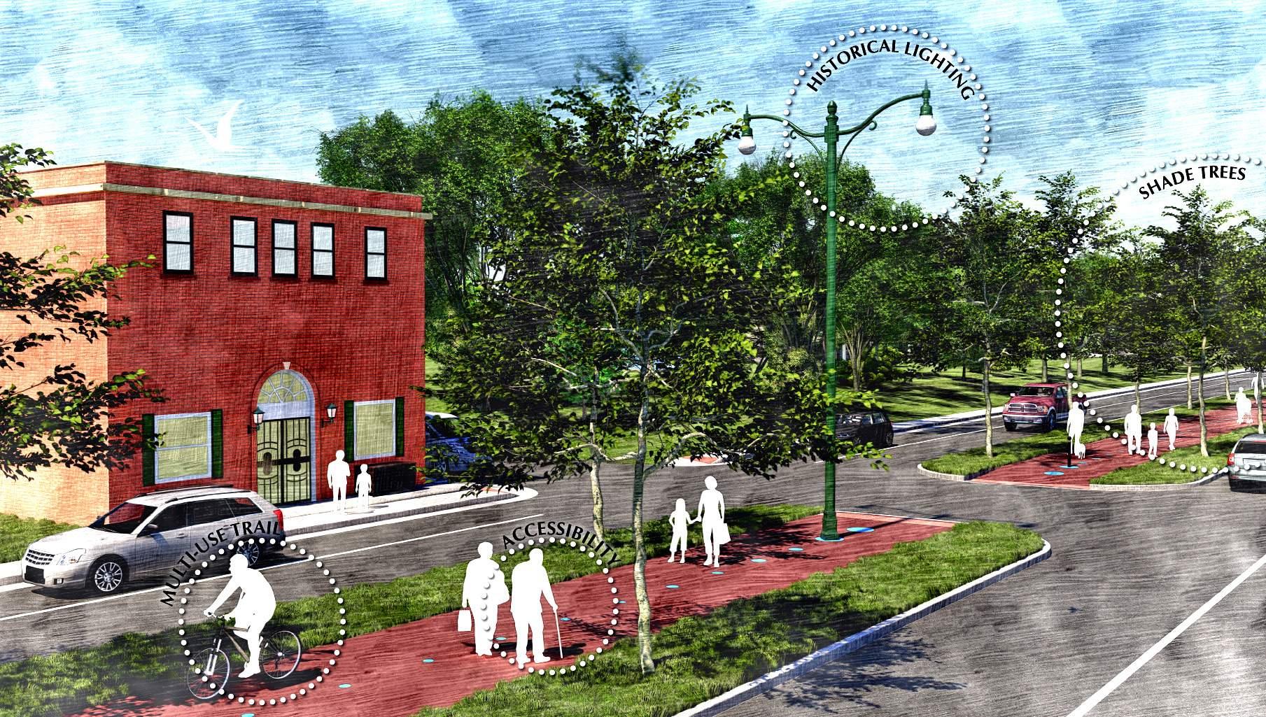
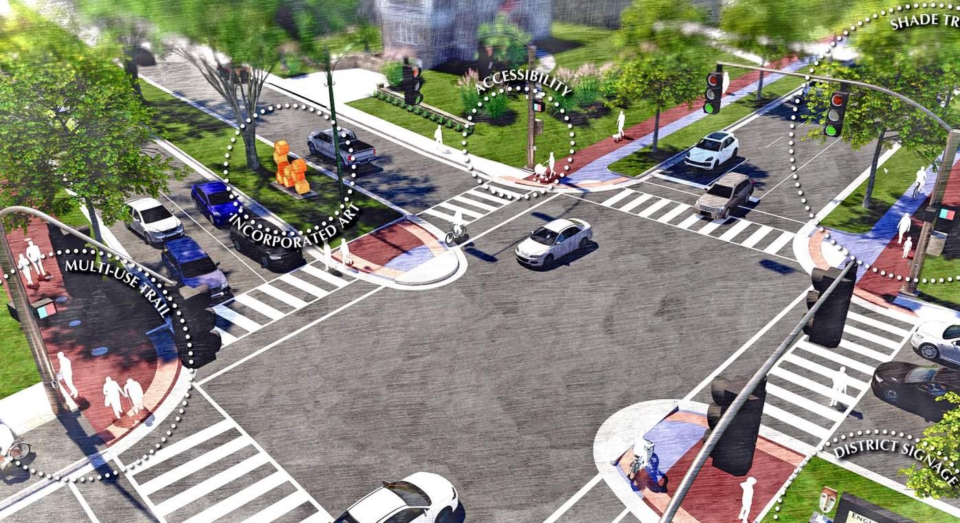
Placemaking is an important aspect of any active transportation project because it combines livability and user sensitivity to make an experience truly memorable and grounds the project in the community. Placemaking features also provide users with a sense of safety, comfort, and delight which is important to help the infrastructure investment maintain sustainable levels of use and additional mode shifting.
The placemaking features identified in this plan should be utilized during the design phase to the extent there is available budget for improvements, available right of way, and sufficient operations and maintenance funds. The features include:
• Expanded parks and green space amenities
• Trees and landscaping
• Historical monuments and interpretive elements
• Branding and wayfinding
• Pedestrian, cyclist, and transit-rider amenities
When it comes to the return on investment in infrastructure, elements such as street and median trees, natural landscaping, and environmental features provide the most “bang for your buck”. Street trees enhance the walking experience by adding a sense of protection and enclosure through vertical canopy and the creation of the “outdoor room”. Landscaping and raingardens are not only good for the environment, they provide a sense of protection, add beauty to the street, and provide visual cues to calm traffic. It is important that landscaped areas are sustainable and maintainable, while also ensuring that pedestrians can cross them and that improvements do not block the view shed of bicycles and vehicles.


Wayfinding compliments and enriches the pedestrian experience and creates interesting streets and spaces, while providing important information about location and direction. Wayfinding information should be conveyed clearly and efficiently with high quality signage and graphic design. When done correctly it will orient and direct pedestrians, locals and visitors alike, to key destinations and parking. It also contributes to the distinct identity of the corridor. Wayfinding should be located on sidewalks, near to intersection corners, near transit stops, places with high pedestrian and bicycle activity, and areas with opportunity for gateway elements and/or public art.
Multi-use trails and greenways are important connections to our parks, open spaces, and natural amenities because they serve as destinations and experiences along the route. It is important to ensure that these spaces have elements such as dog parks, playgrounds, gathering spaces, shelters, tables, benches, trash cans, and other placemaking features that will provide users with amenities and add activity and life to the public realm. These features also provide an important function relative to safety and security by ensuring that there are “eyes on the trail” and augment other passive surveillance activities with Crime Prevention Through Environmental Design (CPTED).
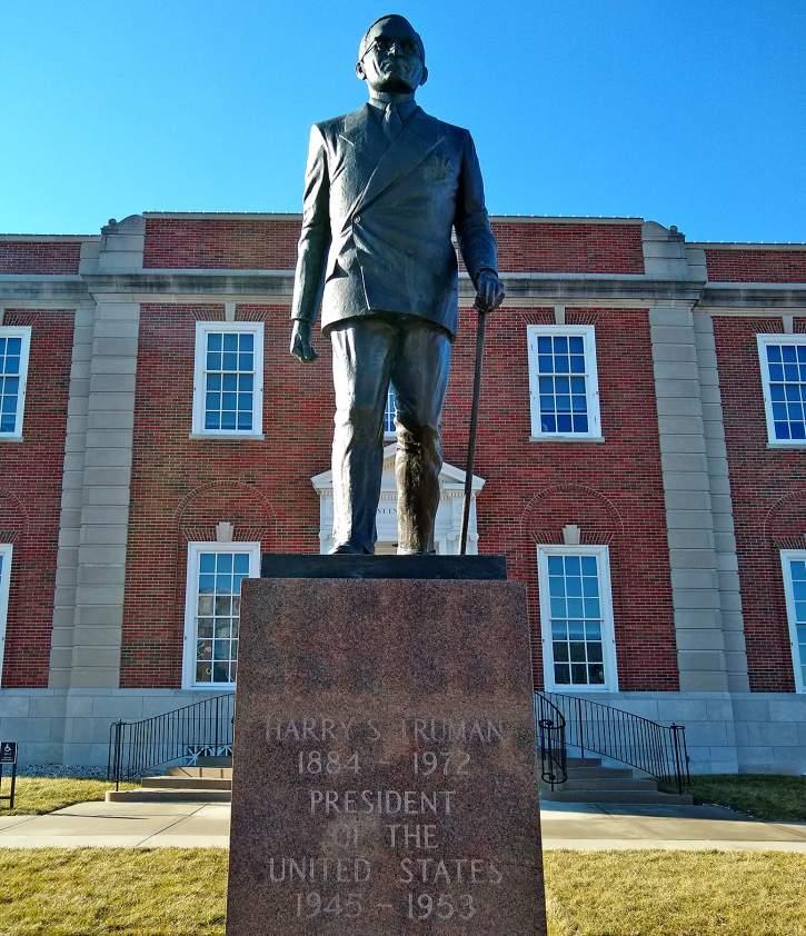
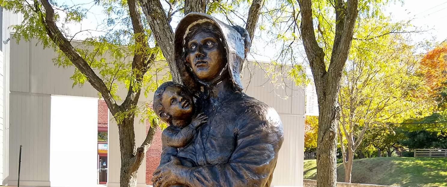
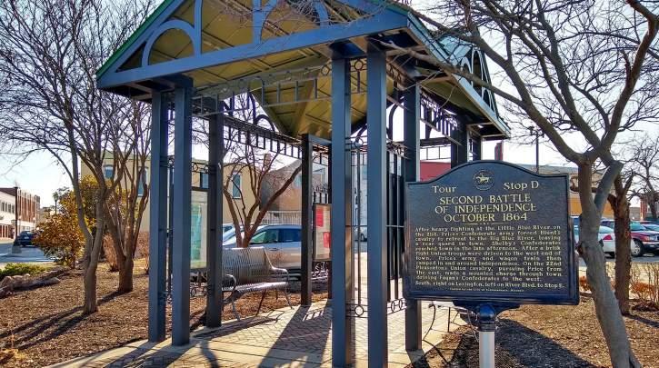
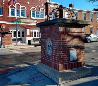
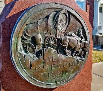
The application of monuments and interpretive elements on greenways and multi-use trails is important because they help to establish the identity of the route while also providing for educational, cultural, and branding opportunities along it. More specifically, there is an opportunity to celebrate the immense history of Harry S. Truman, Andrew Jackson, the wagon trails and other historic narratives surrounding the American Civil War and other American settlement stories. Using these types of elements along the route will ensure there is an emotional and anecdotal link between people and place through the celebration of a uniquely-local narrative.
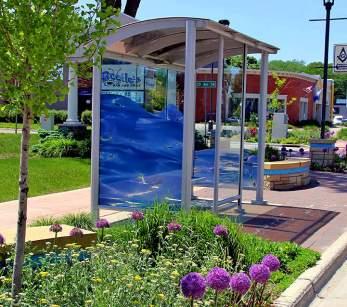
Consideration should be given to adding places to sit, enjoy the city, and connect with the environment. Incorporating benches into transit stops for people to wait for the bus. Putting benches in pocket parks, along the trails, and roadside between developments will provide more opportunities for users to create more liveliness along the corridor. When the participants had the opportunity to vote on bench styles, they preferred benches that were more functional in nature. It is important that transit stops are safe, easily identifiable, accessible, and comfortable places to wait for the bus. A basic bus stop should consist of an accessible paved area and easily identifiable signage.
The Truman Connected plan is a roadmap to improving safety, multimodal access, and improve the quality of life in Independence. The recommendations represent conceptual improvements that the public and Steering Committee have determined to be desirable and appropriate for the area. However, there is more work that will need to take place before a final design is completed and ready for construction due to the nature of the improvements. This section details the next steps on design refinement, funding, and phasing priorities.
A detailed concept plan has been created for Phase 1, and more general concept plans have been created for Phases 2 and 3. However, even for Phase 2, more detailed design work and investigation is needed prior to construction. Specifically, more investigation must be made into utility coordination. Efforts have been made to place Truman Connected in locations to minimize the need for utility relocation and reconstruction, but some will be necessary. Modifications to the locations of curbs will impact storm water drainage and storm inlet locations. Overhead power lines and streetlights also exist along many parts of Truman Connected alignment that may require relocation. Many guides exist for today’s practitioners to utilize. Standard
engineering documents should be referenced for these projects, as with all street design projects. These include the Manual on Uniform Traffic Control Devices (MUTCD) and the Americans with Disabilities Act Proposed Rights-of-Way Accessibility Guidelines (PROWAG) requirements. Beyond those standard guides, the National Association of City Transportation Officials (NACTO) Urban Street Design Guide and Urban Bikeway Design Guide should be referenced for pedestrian and bicycle infrastructure. These design guidelines/best practices will be used to create the safest and highest quality Truman Connected facility.
A particular concern of the public and Steering Committee was creating a facility that would minimize ongoing maintenance costs. There was a strong desire to create a high-quality experience on Truman Connected, but that could remain a high quality experience into the future. This was a concern for all aspects of the project, but in particular for the pavement quality, the amenities, and the landscaping.
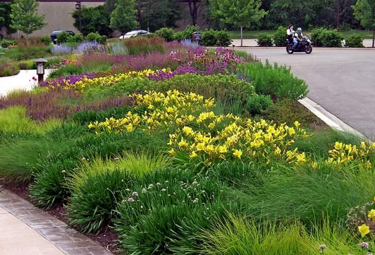
When not planned properly, landscaping can require extensive maintenance. By using a mixed perennial planting scheme, positive effects can be achieved within the aesthetics, maintenance, and even ecology of the green spaces within the corridor. Perennials offer a variety of color, texture, and variation from early Spring through late Fall and even into winter, and many are drought tolerant once established, requiring little or no irrigation. Groundcover type perennials and grasses can spread, fill in gaps, and help to suppress weeds. Instead of putting the burden of weed control on maintenance staff, a mixed perennial scheme utilizes the plant’s abilities to compete and limit weed growth. Furthermore, most perennials and ornamental grasses require only a once-yearly mowing/cutting back, further reducing the need for regular, high-intensity maintenance inputs.
The nature of the construction of the facility for the most part will not significantly increase maintenance costs over what the city currently incurs and, in some cases, will reduce the existing maintenance burden. This is particularly true on Bess Truman Parkway, through the Downtown Square, along Lexington Avenue, and along Sterling Avenue. In these locations, existing pavement currently being utilized
for cars will be repurposed to be used by bicyclists and pedestrians. Cars and trucks damage pavement much more than pedestrians or cyclists, and as a result this repurposed pavement will require much less typical maintenance than if it was being used as a roadway. And because it is repurposed vehicle lanes, it will require no more snow removal or street sweeping than the roadway did. It is anticipated that the facility will be constructed using asphalt pavement instead of concrete pavement where new pavement is needed.
This will further limit the maintenance input required by the city. Concrete typically has a longer design life than asphalt pavement on roads, but with very limited vehicle traffic on Truman Connected, the design life differences between concrete and asphalt will be negligible. Asphalt is much cheaper and easier to maintain and repair than concrete. Where concrete often requires full depth pavement replacement where damage has occurred, asphalt can be milled to smooth the surface and thin pavement sealers can be applied to refresh the surface. Asphalt also has the added benefit of providing a smoother and more comfortable surface for cyclists and pedestrians.
ATI: Associated Transit Improvement (1% set‐aside of FTA)
BUILD: Better Utilizing Investments to Leverage Development Transportation Discretionary Grants
CMAQ: Congestion Mitigation and Air Quality Improvement Program
FTA: Federal Transit Administration Capital Funds
HSIP: Highway Safety Improvement Program
NHPP: National Highway Performance Program
RTP: Recreational Trails Program
SRTS: Safe Routes to School Program / Activities
STBG: Surface Transportation Block Grant Program
STP: Surface Transportation Program
TA: Transportation Alternatives Set‐Aside (formerly Transportation Alternatives Program)
TAP: Transportation Alternatives Program
TIFIA: Transportation Infrastructure Finance and Innovation Act (loans)
High level cost estimates were prepared for all three project phases. A more detailed cost estimate was produced for Phase 1 and less detailed cost estimates have been produced for the ultimate improvements in Phase 2 and all improvements in Phase 3. These project costs and general project cost categories can be seen in the table on this page.
Phase 1 construction of the Truman Connected has been fully funded at the time of this plan production. This funding has been procured from several sources including federal Surface Transportation Program (STP), federal Transportation Alternates Program (TAP) funds and local City funds. The federal funds will pay for approximately 80% of the total construction cost, with the City providing the remaining 20% of the project funds. The funding currently available for construction will cover the entire Phase 1 project cost estimated at $3.9 million. The city has also identified separate funding using the Street Sales Tax to pay for professional design services on the project. These funds will be available to start final design on Phase 1 in the summer of 2020 with construction funds available for use in the summer of 2021.
Funding for Phases 2 and 3 have not yet been identified for the Truman Connected facility, but efforts have begun to secure funding for these important extensions of the project. Many funding mechanisms exist for this type of project, as have been used for the Phase 1 construction. Federal programs that may be especially applicable to Truman Connected in addition to the STP and TAP funds used for Phase 1 are Better Utilizing Investments to Leverage Development (BUILD) discretionary grants, Congestion Mitigation and Air Quality (CMAQ) funding, and Highway Safety Improvement Program (HSIP) funding. The BUILD grant program is designed for medium sized transportation projects (typically in the $5M$25M range), whereas the CMAQ program typically fund smaller projects. HSIP funding is specifically for safety improvements.
The BUILD grant or STP funding may be a good candidate for Phase 2 improvements (estimated at approximately $7 million). Because of the high crash rates on Sterling Avenue and major safety improvement potential of the concept in this plan, it may be possible to procure HSIP funding for Phase 2 as well. CMAQ or TAP funding may be good candidates for Phase 3 (estimated at approximately $2 million). Recreational Trails Program (RTP) funding may also be a good candidate for Phase 3 given the connect to the Rock Island Rail Corridor trail planned for this segment. The chart on this page describes other potential federal funding sources for the extensions of the Truman Connected facility.
For Additional Information Please Contact:
Tom Scannell Community Development DirectorThe City of Independence, MO
111 East Maple Avenue
Independence, MO 64050
(816) 325-7830 | tscannell@indepmo.org