


2 www.independencemo.org/parksandrec 816-461-0200 1700 S. Noland Rd. Independence, MO 64055 GO GREEN!!! Be a part of the solution… Drive a KIA KIA strives to provide consumers with the best cars, lowest emissions and great gas mileage!! Check one out at Bob Sight Kia…where there’s no B.S.!
TABLE OF CONTENTS
BINGHAM-WAGGONER
The walking trail is adjacent to the famous Bingham-Waggoner home. The home was built for John Lewis and in 1899, William H. Waggoner remodeled the house extensively. In 1864, the property was bought by George Caleb Bingham, a famous Missouri painter. One of Mr. Bingham’s infamous paintings is “Order No. 11.” The Santa Fe Trail originally ran along the east side of the property, later switching to the west side of the property. The walking trail is located behind the stately house. To access the trail, walk across the footbridge. The trail is a hard-surface trail with some mild inclines and is surrounded by the swales created by the wagon trains passing through the property in the 1830s. (Foerster, 1978, p. 99)
1,938 Feet
Independence Trail Guide 3
Bingham-Waggoner.......................……….............................…………....................................................….........3 Bundschu Park…………………………………….............................…………..........................................….........4 Centerpoint Medical Center………………….............................…………................................................…........4 Choosing a Pedometer………………….............................…………………….............................…..…..…..…..11 Clothier Park Walking Trail………………….............................…………..................................................…........5 Country Club Park…………………………………….............................………….................................................6 Distance Calculator………………………………….............................…………..................................................15 Fairmount Park……………………………………............................…………..........................................….........6 George Owens Nature Park.......……………………….............................…………..................................…........7 Glendale Park…………………………………….............................……..…............................................…..........7 Hill Park…………………………………….............................………….....................................................….........8 Independence Athletic Complex…………….............................…………...............................................…..........8 Little Blue Trace……………………………….............................…………...............................................…..........9 Maple Forest Community Park……………….............................………….........................................................12 McCoy Park…………………………………….............................…………................................................….....13 McCoy Park to Mill Creek Connecting Trail…............................…………...............................................…......14 Mill Creek Park………………..……………….............................………….................................................….....14 Missouri Department of Conservation……….............................…………...............................................…......15 Missouri Mormon Walking Trail………………………..................…………...............................................…..... 16 Phil Roberts Park………………………………............................…………..............................................….......17 Rotary Park……………………………………..............................…………...............................................…..... 16 Safety Tips/Taking the First Step...…………..............................…………................................................….....10 Santa Fe Trail Park…………………………….............................…………...............................................…..... 18 School Trails…………………………...……….............................…………...............................................…..... 10 Sycamore Hills Park…………..……………….............................…………...............................................…..... 18 The Hoof-N-Hound…………………………….............................…………...............................................…..... 19 Trail Etiquette…………………………....…….............................…………...............................................….......11 Truman Historic Walking Trail………….......................................……….......................................................... 20 Young Park…………………………………….............................….………...............................................…..... 22 Walking Benefits…………………………………….............................………...........................................…........9 Walking Shoes…………………………………….............................……..................................................…..... 10 Hiking Safety.........…………………………….............................…………...............................................…......15 Waterfall Park Trail…………………………….............................…………...............................................…..... 20 Waterfall Park to Little Blue TraceTrail.......................................…………...............................................…..... 21
313 W. Pacific Ave. Trail = 1/4 mile
Bingham-Waggoner
This park was named after the Bundschu family, who owned a store on the east side of the Independence Square. Mr. Bundschu once said, “It is pretty hard for you to visualize the difference between Independence and Kansas City after the Civil War. We looked down upon Kansas City as just a tough river town.” The welfare office relied on Mr. Bundschu when funds were low. When asked “What would you like most to see accomplished for Independence?” He replied, “The building of the bridge at Courtney and completion of the roads and viaducts to make it effective.” (Wilcox, 1979, p.71)
Centerpoint 5,618 Feet
4
www.independencemo.org/parksandrec
BINGHAM-WAGGONER
19600 E. 39th St. Trail = 1/5 mile
11400 E. 9th St. S. Trail = 1/5 mile
BUNDSCHU PARK TRAIL CENTERPOINT MEDICAL CENTER TRAIL
Bundschu Park 822 Feet
CLOTHIER PARK


Clothier Park was dedicated in 2010 in honor of Dr. Robert W. Clothier. “Dr. Bob,” as he was affectionately known, was a noted pediatrician and community leader who impacted the lives of numerous children in the Independence community and believed in making a difference.


Independence Trail Guide 5
17203 E. 23rd St. Walking Trail Trail = 3 1/2 laps = 1 mile
Clothier Park 1,893 Feet
Country Club Park
1,058 Feet
FAIRMOUNT PARK
For 36 years, Fairmount Park was a place for summer fun and water sports. (“Many Parks,” 1973) Canoes and boats were available for rental and a beach was available for sunbathers and swimmers. There was a two-story bathhouse and amusement park for the community to enjoy as well. Originally an eight-acre lake was located at the park; now Highway 24 is located there. According to the Kansas City Star, “The park was Arthur Stillwell's creation and was planned primarily to furnish trade for his air-line interurban line, which ran from 2nd and Grand in Kansas City to Independence. Records show that as many as $15,000 in fares were collected in a single day. Between 1897 and 1901, a nine-hole golf course was maintained by the private Evanston Golf Club. In 1933, the park suffered a major fire. Between the fire, a problem with water pollution, and the great depression, the park closed. Fairmount Park is located east of this older park and has been named after it.”
Fairmount Park 3,214 Feet
6 www.independencemo.org/parksandrec
300 N. Home Ave. Trail = 1/4 mile COUNTRY CLUB PARK 2930 S. Norton Ave. Trail = 1/4 mile 19600 E. 39th St. Trail = 1/5 mile
1601 S. Speck Rd.
Trail = 4 miles
This section of Jackson County was settled in the 1820s. The property, which later became George Owens Nature Park, was acquired from the government by Thomas Stayton, a prominent pioneer in Jackson County. The majority of the park was at one time cleared and used for farming. During the past 100 years, various fields were abandoned, which allowed the natural process of ecological succession to occur. Today, most of the park is covered with trees, resembling the foliage-covered land the pioneers first discovered. (Independence Parks & Recreation Department, 2005).
13,564.41 Feet
Glendale Park 1,302 Feet
2930
Independence Trail Guide 7
GEORGE OWENS NATURE PARK
GLENDALE PARK
Crackerneck and Lee’s Summit Rd. (Intersection of Lee’s Summit Rd. and Crackerneck Rd.)
S. Norton Ave.
Trail = 1/3 mile
George Owens
HILL PARK
2201 S. Maywood Ave.
(Southeast corner of E. 23rd St. and Maywood Ave.) Trail = 1/2 mile
In 1927 the Jackson County Court accepted a 12-acre gift as a memorial to William M. Hill, son of Adam Hill, an 1833 Jackson County Pioneer. The Hill Family Cemetery is located within the park and includes Rock Creek and limestone outcroppings. The once rundown park is now in a state of regeneration and has recently sprung back to life. In 2005, a skateboard facility was built for the youth and the young-at-heart. A hard-surface walking trail, a playground, and a shelter have been added. (Wilcox, 1979, p. 154)
2,964 Feet
INDEPENDENCE ATHLETIC COMPLEX
17800 E Salisbury Rd. Trail = 1.5 miles
This 165-acre complex is one of the most unique in the country in that it sits atop the Space Center, Inc. warehouse, a 4.4 million square-foot subsurface complex of office, warehouse and light manufacturing space.
Independence Athletic Complex
7,493 Feet
8
www.independencemo.org/parksandrec
Hill Park
LITTLE BLUE TRACE TRAIL
Entrances are located at Blue Mills Rd., Ripely Junction, Bundschu Rd., M-78 shelter just west of Hwy. 7 and Necessary Rd. at R.D.Mize Rd. Trail = 14.17 Miles
This trail follows the Little Blue River and winds through forest and farmland. When heading north on the trail, mile markers on the ground to the left of the trail help guide the way. Composed of rock with paved portions, the trail’s surrounding area is also scenic and fairly flat with a few hills. Historic markers along the trail include the Indian Trace Trail, Trail of Tears, and the Battle of Westport. This trail is a wonderful place to view wildlife. (Jackson County Parks & Recreation Department, 2005)
Little Blue Trace
14.17 Miles
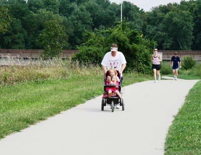
WALKING BENEFITS-AREAS OF THE BODY WALKING BENEFITS
Arms
Abs
Knees and Ankles
Upper and Lower Legs
Hips and Butt
If you thought walking was just putting one foot in front of the other, you were right! But check out these tips for how to walk and breathe correctly so your walk will be safer and easier.
Posture. How you hold your body is important. Stand up straight and tall. This means putting your shoulders back and relaxing them (no slouching!), and keeping your chin up and stomach in. It's a good idea to look 20 feet ahead—about the length of two cars. This keeps your chin up and your eyes on your path!
Taking your first steps. Start your first step with the heel first. Then roll your foot from heel to toe and push off the toes with the next step. Bringing the opposite leg forward, repeat this again. (This may feel a little funny at first but as your muscles get stronger it gets easier.)
Arm motion. Moving or swinging your arms when you're walking can give you power and it balances what your legs are doing! Bend your elbows 90 degrees (so your arms look like the letter "L"), while keeping your hands slightly curled. When you step, one foot moves forward and the arm opposite this foot should come forward too. As your foot goes back, bring back the opposite arm with it. Keep your elbows close to the body so you don't have "chicken wings."
Don't forget to breathe! Your breathing should have a rhythm. Inhale one deep breath for four steps and then hold that breath for two steps. Then exhale to the count of four steps, and hold it for two steps before beginning all over again. So the rhythm is — breathe in (step 1, 2, 3, 4), hold (step 1, 2) breathe out (step 1, 2, 3, 4) hold (step 1, 2).
Everyone's stride is different, so if you feel that four steps are too long or too short, adjust it to what is comfortable for you.
National Public Lands Day Source: CDC
http://www.bam.gov/sub_physicalactivity/activitycards_walking.html
Independence Trail Guide 9
SCHOOL TRAILS
CHOOSING WALKING SHOES
The most important factor in choosing good walking shoes is to select a good fit. Select shoes designed specifically for walking, thereby providing comfort and appropriate support. A walking shoe should have a low, rounded heel to allow a good rolling motion from the heel to the toe. The shoe should bend where your foot naturally does and not at the arch. The shoe should also have slight flexibility when you grab the heel and toe and give the shoe a twist. Walking shoes should be replaced about every 500 miles.
Sledding - With or Without Snow
HEAT SURVIVAL TIPS
Drink two - four glasses of water each hour. Drink plenty of non-alcoholic fluids. Do not wait until you are thirsty to drink. Thirst is your body’s way of telling you that you’re dehydrated.
Avoid very cold drinks, caffeine and high sugar drinks.
Sports beverages can replace the salt and minerals you lose in sweat. Eat lightly. High protein foods will increase heat production and water loss, while fatty foods are harder to digest. Eat salads, fruit, jello and vegetables.
Try to rest often in the shade. Protect yourself from sunburn, it reduces the body’s ability to cool itself. Listen to your body, slow down and rest as needed. Wear light-colored, light-textured and loose-fitting clothes.
COLD WEATHER WALKING TIPS
Start your walk INTO the wind, so you will finish with it at your back. Drink plenty of fluids. You may not sweat, but breathing in cold air also depletes liquids. Protect your eyes and skin: In winter the earth is closer to the sun than in summer. The sun's radiation as well as the wind can damage your skin and eyes. Wear sunscreen and sunglasses that screen out the UV rays. Sunlight reflecting off snow can do a lot of damage to your eyes if not screened.
Preventing slips: Select routes that are cleared of snow or ice or do not have standing puddles or mud slicks.
TAKING THE FIRST STEP
Walking correctly is very important. Walk with your chin up and your shoulders held slightly back. Walk so that the heel of your foot touches the ground first. Roll your weight forward. Walk with your toes pointed forward. Swing your arms as you walk.
If you walk less than three times per week, give yourself more than a week before increasing your pace and frequency.
10 www.independencemo.org/parksandrec
Benton 429 S. Leslie Track: 4 laps = 1 mile Bingham 1716 Speck Rd. Bingham to Bridger = 1/4 mile paved sidewalk Blackburn 17302 R.D. Mize Rd. Sidewalk around park: 5 laps = 1 mile Blue Hills 1911 N. Blue Mills Rd. 4 laps around playground = 1 mile Bridger 18200 E. M-78 Hwy. Bridger to Bingham = 1/4 mile paved sidewalk Bryant 827 College Track: 9 laps = 1 mile Christian Ott 1525 N. Noland Rd. Track: 6 laps = 1 mile Cler-Mont 19009 Susquehanna Ridge Trail: 4 laps = 1 mile Fairmount 120 N. Cedar 9.4 laps = 1 mile Fort Osage High 2101 N. Tywman Rd. Track around football field Glendale 2611 Lee’s Summit Rd. Track: 7 laps = 1 mile Hanthorn 1511 S. Kings Highway Children’s bike trail Luff Elementary 3700 S. Delaware Track: 4 laps = 1 mile Mill Creek 2601 N. Liberty Track: 14 laps = 1 mile Procter 1403 W. Linden Track: 7 1/2 laps = 1 mile Randall 509 Jennings Track: 4 laps = 1 mile Santa Fe 1301 S. Windsor Track: 10 laps = 1 mile Spring Branch 20404 E. Truman Rd. Track: 7 1/2 laps = 1 mile Sunny Vale 3830 S. R.D. Mize Rd. 4 laps = 1 mile Sugar Creek 11424 Gill 4.9 laps = 1 mile Sycamore Hills 15208 E. 39th St. Track: 9 laps = 1 mile Three Trails 11801 E. 32nd St. 6.1 laps = 1 mile Truman High 3301 S. Noland Rd. Track: 7.8 laps = 1 mile Van Horn High 1109 Arlington Track 4 laps = 1 mile William Chrisman High 1223 N. Noland Rd. Track: 4.6 laps = 1 mile William Southern 4300 Phelps Rd. Playground: 8.5 laps = 1 mile William Yates 3600 S. Davidson Disc golf course trail
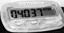
CHOOSING A PEDOMETER
A pedometer can give you a more accurate picture of how active you are each day.
The pedometer step counter is a small battery operated device that tracks vertical movement of the hip. The pedometer is worn at your waist directly above the knee and records a step each time your hip moves up and down.
Wearing a pedometer can help you manage your activity and serve as a constant reminder to get up and move.
Your pedometer will measure all activities involving hip movement. To work, the pedometer has to stay upright and not tilt too much. When positioned on a body with a protruding stomach, the pedometer should be worn on the waistband directly below the armpit. Choose a pedometer that is best for you. Basic models count only steps while other models can convert steps to miles and track calories burned.
Inexpensive models tend to be noisy, harder to use, not as accurate and will not last long. Buy a safety leash or strap to keep the pedometer from falling off.
SAFETY TIPS
Follow these steps: Wear your pedometer for at least three days from morning until night to determine how many steps you normally take in a day.
Take the total number of steps walked during three days and divide by three for your baseline number of steps per day.
The target goal is 10,000 steps per day.
Simply wearing a pedometer is not enough. You will also need to record your readings.
Once you have reached your goal, maintain that number for at least eight weeks. After that, you may then choose to increase your daily goal or add intensity to your program by walking further or by including more hills and stairs.
Keep safety in mind when you plan your route and the time of your walk. If you walk at dawn, dusk, or night, wear a reflective vest or brightly colored clothing. Walk in a group when possible. Notify your local police station of your group’s walking time and route. Do not wear jewelry or headphones.
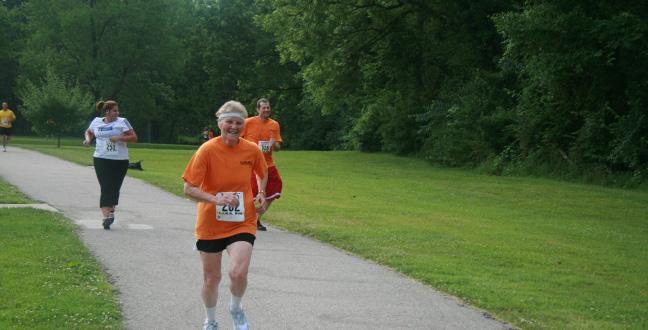
WALKING FUN FACTS
Walk up and down the aisle of a discount store and around the outside aisle for 550 steps. Walk from one end of Independence Commons to the other for about 825 steps. Walk around a grocery store for approximately 800 steps.
The top level of Independence Center is approximately 1,050 steps and the bottom is about 994 steps. 2,000 steps = 1 mile.
Going for a walk is a great way to reduce stress and promote an overall sense of wellness. Regular walking can reduce feelings of depression and anxiety.
Walking burns approximately the same amount of calories per mile as does running.
Walking is the only exercise in which the rate of participation does not decline in the middle and later years. In a national survey, the highest percentage of regular walkers for any group (39.4%) was found among men 65 years of age and older.
Walking leads to lean, toned muscles, and keeps bones and joints in shape, minimizing the effects of osteoporosis and arthritis.
TRAIL ETIQUETTE
Stay on designated trails.
Bike riders yield to hikers.

Downhill yield to uphill.
Use common sense and courtesy. Do not litter.
Please do not destroy or remove plants.
Keep your pets restrained.
Walk on the right.
Show courtesy to other trail users at all times. Use the right side and always pass on the left.
Respect the rights of property owners.
Watch for other trail users.
Be especially alert when running.
Listen for audible signals and allow faster trail users (runners and bicyclists) to pass safely.
Group users allow ample room for others to pass. Always look ahead and behind before passing.
Yield when entering and crossing trail.
Obey all traffic signals and stop signs.
Independence Trail Guide 11
MAPLE
Lexington St. and Maple Ave.
Trail = 1/2 mile
This park was created in memory of Suzanne McGrath. Suzanne was a nurse at the former Independence Regional Health Center who while running was struck and killed by a car. Her dedication to exercise and fitness encouraged her friends to establish the park in her honor. The purpose of the park is to enrich people’s bodies and minds in a safe environment. The park provides a place to spend quiet moments and a place to pursue a life of fitness and preventive health. An integral part of the park is a memory garden where supporters have purchased stones of varying sizes to be engraved with remembrances or the name of a lost loved one. The park has a playground, benches and lights. (Independence Regional Health Center, 2000)
Maple Forest Community Park
1,021 Feet
George Owens Nature Park
1601 S. Speck Rd., 64057
(North of intersection of E. 23rd St. and Speck Rd.) (816) 325-7115
George Owens Nature Park has given families the opportunity to reconnect with their natural environment since 1977. The park is open year round and provides 86 acres of beautiful forest, lakes, hiking trails and wildlife. Explore the rustic nature center and find new seasonal exhibits. Get up close to a beaver, touch antlers, or count the rings on a tree. Experience the beauty of a 150-gallon freshwater aquarium full of Missouri fish or peer into a 75-gallon turtle enclosure. The possibilities for adventure are endless.
Park Amenities
Five Hiking Trails (One Paved)
Two Fishing Lakes
Organized Group Campground
ADA Accessible Dock
Family Picnic Area
Nature Center
Rain Gardens Pavilion
www.georgeowenspark.org
www.independencemo.org/parksandrec
12
ADVENTURE OASIS WATER PARK
FOREST
COMMUNITY PARK TRAIL
McCOY PARK TRAIL


This park is named after William McCoy, who originally came from Ohio and later became the first mayor of Independence in 1849. “He was a banker and Indian trader and lived there until his death in 1900.” (Foerster, 1978, p. 43) The McCoy home is located on Farmer Street, not too far from McCoy Park. William McCoy and his brother John flipped a coin to see if they would stay in Independence or settle in St. Joseph. Needless to say, Independence won. (Henley, 1986, p. 46)

McCoy Park 1,257 Feet


Independence Trail Guide 13
800 N. Bess Truman Pkwy. (Southeast corner of N. Delaware St. and U.S. Hwy. 24) Trail = 1/4 mile
14
www.independencemo.org/parksandrec
Tadpole Trekking
McCOY PARK TO MILL CREEK PARK TRAIL
Connecting Trail Tennis Courts on Jones St. to U.S. Hwy. 24 and Bess Truman Pkwy. Trail = 1/2 mile
1717 N. River Blvd. Trail = 1/4 mile
MILL CREEK PARK TRAIL
McCoy to Mill Creek 2,812 Feet
Mill Creek Park 1,219 Feet
MISSOURI DEPARTMENT OF CONSERVATION TRAIL
Santa Fe Park (East Side)
2900 S. Santa Fe Rd.


Trail = 1/2 mile

The land for this trail was donated by Lipton and was the Lipton Conservation Area. The trail is a loop, covered by crushed pea gravel, wooded and secluded in spots. (Missouri Department of Conservation, 2005)

Independence Trail Guide 15
MO Dept. of Conservation 3,045 Feet
MISSOURI MORMON WALKING TRAIL
West of River Blvd. on Walnut St. Trail = 1 mile
The Mormon Walking Trail is a joint project of the City of Independence and the Missouri Mormon Frontier Foundation (MMFF). MMFF is a non-sectarian, not-for-profit group dedicated to the promotion and understanding of local history. There are 14 plaques along the trail that depict key early Mormon sites. (Independence Parks & Recreation Department, 2005).
ROTARY PARK TRAIL
Rotary Park is located in one of the most interesting and historical areas in Independence. Many historians interested in the James Gang (Frank and Jesse James) are aware that this was a popular hangout spot for Frank James, a Santa Fe merchant. He fell in love with Annie Ralston, the daughter of Samuel Ralston, and lived in the large 1850s mansion at 21st Street and Sterling Avenue. Ralston was a teacher at Rock Creek School, a one-room school at the top of the hill, just west of the park. Ralston’s father was opposed to this marriage and the school board refused to void her contract to allow them to get married. That night the schoolhouse burned to the ground, thereby leaving James and Ralston free to marry. The two are buried side by side in the small family cemetery on the north side of Hill Park. James is buried under the alias F. Alexander James to avoid his marker from being vandalized like Jesse James’ marker in Kearney. A Civil War Battle was fought on the hill to the west of the park and the Independence Fair was also located at this spot. (B. Curtis, personal communication, March 2006)
1,921 Feet
www.independencemo.org/parksandrec
16
10615 E. 24th St. S. (South of E. 23rd St. and just of south of Westport Rd.) Trail = 1/4 mile
Mormon Walking Trail
6,399 Feet
Rotary Park
PHIL ROBERTS PARK TRAIL
3250 S. Blue Ridge Blvd. (Blue Ridge Cutoff and 40 Hwy.)
Asphalt Walking Trail = 1/3 mile
Nature Trail = 1/4 mile
Next to the parking lot of Phil Roberts Park is the old Pitcher Cemetery. The cemetery dates back to the early 1830s. Ledstone Noland, who served in the Revolutionary War, is buried at this cemetery along with Civil War soldiers and the Pitcher Family. The last known burial at this cemetery is believed to have been in 1812.
The park was recently renovated and offers a place of solitude amidst the city traffic. The asphalt trail is level except for the slight incline at the northwest corner. The Chinook Oak tree (with bluebird houses mounted on it) provides shade for the walker. Adjacent to the trail is a 1/4-mile nature trail through a wooded area for a more adventurous walk.
1,605 Feet
Independence Trail Guide 17
19100 E. Valley View Pkwy. Independence, MO 64055 (816) 442-6138
Phil Roberts Park
Hills Park
Feet
18 www.independencemo.org/parksandrec
2731
SANTA FE TRAIL PARK TRAIL
S. Santa Fe Rd. Trail = 1/2 mile
15208 E.
St.
There are immigrant pioneer wagon wheel ruts running the length of the property.
39th
S. Trail = 1/5 mile
SYCAMORE HILLS PARK TRAIL
Santa Fe Park
2,372 Feet
Sycamore
1,451
THE HOOF-N-HOUND TRAIL
875 Vista Ave.
Trail = 3/4 mile
The Hoof-N-Hound is a walking program sponsored by the Independence Animal Shelter. Gym membership can cost more than $50 a month, but this weight-loss program is free-n-furry. Why not consider providing yourself some daily exercise by walking or jogging with a shelter dog? You will receive a membership card and a certificate after completing 10 miles of hoof-n-exercise. All participants must check in with their club membership photo I.D. prior to the walk. This is for the protection of the animals as well as yourself (Independence Animal Shelter).
DISTANCE CALCULATOR
PEDOMETER EQUIVALENTS


The Building a Healthier Independence Grant funded a portion of the printing cost for the Independence Trail Guide with funding from The Missouri Foundation for Health.
The City of Independence is an equal opportunity/ affirmative action employer. Services provided on a nondiscriminatory basis. Material partially funded by the Missouri Foundation for Health.
Independence Trail Guide 19
1/16 mile = 330 feet 1/8 mile = 660 feet 1/6 mile = 880 feet 1/5 mile = 1,056 feet 1/4 mile = 1,320 feet 1/3 mile = 1,760 feet 2/5 mile = 2,112 feet 1/2 mile = 2,640 feet 3/5 mile = 3,168 feet 3/4 mile = 3,960 feet 2/3 mile = 3,520 feet 1 mile = 5,280 feet
1 mile = 2,000 average steps (range 1,900 - 2,400) 1 block
= 200 average steps
TRUMAN HISTORIC WALKING TRAIL
223 N. Main St. Trail = 2 7/10 miles
The City of Independence started developing plans for this historic walk in the early 1990s. President Harry Truman, America’s 33rd president, enjoyed walking and history. To honor his love of walking, the City organized the Truman Historic Walking Trail. There are 43 memorable sites along the way that are marked by descriptive plaques. It is said that “no one liked a good walk better than Independence’s own Harry Truman.” Take time to enjoy the sights. (Independence Parks & Recreation Department, 2005)
11,876 Feet
Asphalt paved trail = 1.25 miles
This picturesque trail brings you upclose to a beautiful lake, waterfalls and a playground complete with a climbing wall. The trail winds along natural grass fields and through a quiet tree-lined path offering a quiet place to relax and unwind while enjoying the beauty of nature.
Waterfall Park 11,876 Feet
www.independencemo.org/parksandrec
20
4501 S. Bass Pro Dr. I-70 and M-291 Hwy. Hiking trail = 1.25 miles
WATERFALL PARK TRAIL
Truman Historic Walking Trail
Independence Trail Guide 21 WATERFALL PARK TO LITTLE BLUE TRACE TRAIL 4501 S. Bass Pro Dr. I-70 and U.S. Hwy. 40 2100 S. Hub Dr. Independence, MO 64050 816 325-SWIM
Waterfall Park to Little Blue Trace Trail 2,911
Feet


22 www.independencemo.org/parksandrec 300 N. Hocker Trail = 1/8 mile YOUNG PARK TRAIL Young Park 958 Feet


Independence Trail Guide 23