THE FAIRMOUNT DISTRICT PLAN
Developing a Sustainable Place along the US-24 Fairmount Community Corridor

Master Plan 2017
Final Document

Developing a Sustainable Place along the US-24 Fairmount Community Corridor
Final Document
Developing a Sustainable Place along the US-24 Fairmount Community Corridor
Final Document
Commitments from four entities, City of Independence, Mid America Regional Council, and Missouri Department of Transportation comprise the funding and decisionmaking structure for the Master Plan.
The City of Independence, Independence School District, Surrounding Neighborhoods, Residents and Business Owners have a very important role in the redevelopment of the corridor.
The Mid America Regional Council is a nonprofit association of city and county governments and the metropolitan planning organization for the bistate Kansas City region serving 119 cities including Independence. We provide a forum for the region to work together to advance social, economic and environmental progress.
The Missouri Department of Transportation owns and maintains US-24. They work with the City of Independence, state and federal legislators to provide a safe and efficient transportation system to the people of Missouri.
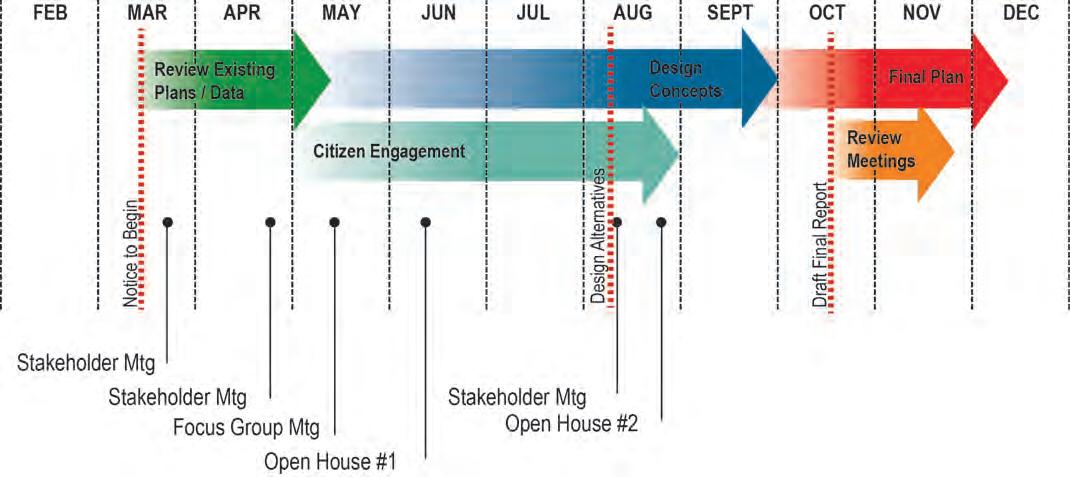
The project began in March of 2017. CFS Engineers was selected to lead the design efforts. Over the 8-month planning process, data collection, analysis, concept generation, public engagement, business owner conversations, planning recommendations, finance recommendations and implementation project identification were completed. The project was completed in October of 2017.

The design team has worked extensively with the public, client, and consultants during the research, analysis, and conceptual design process. An ongoing public input process solicited feedback about existing conditions and proposed direction for the district plan. Client feedback from the City of Independence, MARC, and MoDOT has helped steer the master plan.
A large team of local professional consultants has been engaged to guide the discovery of opportunities necessary to produce a design that takes into consideration the area’s complex technical aspects.
Input from these sources was critical to the team’s understanding of the pedestrian, vehicular, commercial and residential land uses, the generation of concepts, development of the proposed implementation plan and the ongoing refinement from feedback received throughout the process.


Sabin Yanez
Jim Schuessler
Neila Seda
Andrew Robertson
Tom Ingram
Richard Stegman
Thomas Morefield
Erin Ollig
Lauren Garrott
Financing Opportunities
Craig Davis
Sheila Shockey
Development Interests / Historic Preservation
Vincent Gauthier
Drone Photography
Tom Lesnak, Independence EDC
Presented at City Council Worksession on December 11, 2017
Planning Commission on January 23, 2018 and Adopted at City Council on February 5, 2018
Mayor
Eileen Weir
City Council Members
John Perkins - District 1
Curt Dougherty - District 2
Scott Roberson - District 3
Tom Van Camp - District 4
Chris Whiting - At-Large
Karen DeLuccie - At-Large
Planning Co-Chair
Charlie Dissell (City of Independence - Assistant Community Development Director)
Jennifer Manuleleuaj (Community Services League)
City of Independence
Mark Randall
Lauren Palmer
Eric Fitch
Tim Gramling
Carl Perry
Eric Urfer
Kati Horner Gonzalez
Mike Winckler
Mike Jackson
Ann Smith-Tate
Mary Hunt
MARC
Darryl Fields
KCATA
Shawn Strate
Brien Starner
SCEMO
Scott Samuels
City of Sugar Creek
Mike Larson - Mayor
Ron Martinovich - City Administrator
Truman Medical Center
Felisa Freiley
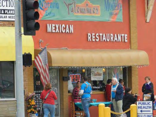
Restaurants
Pedro Lopez - Los Amigos
Veronica Chave - Palomino’s
Citizens / Property Owners
Christina Leakey - Truman Heritage Habitat for Humanity
Alex Gilpin - Revive Church
Jeff Anger - ISD Schools
Tony Toniappa - Wholesale Auto Outlet
Glen Walden - Auto Wash
John Kramer - Kramer Products
Rose Hernandez
Ed Blackburn
Kimo Manuleleua - IEC
Betsy Waldman - ISD
Jodi Krentz - Independence EDC
Merideth Parrish - ISD
Mary Backer
Esterh Varquez
Angelica Garcia
Doug Cowan - Community Sercies League
Tryphosa Sammon
Robert Siesener
Denise L Poenton
Bonnie Hilburn
Mary K. Johnson
Amanda Buhl
Remol Ann Fain Henning
Mark O’Renick - Will & Grail
Velia Howarth
Rohn Grotenhuis - BNIM
Tom Palmer
Nancy Storey
Fritzanna Dee Lyke
Mark McDonald
Suzie Larson
Ray Pocock
Ron and June Thomas - M&T Rental
Leigh Ann Little - IC News
John Olnsk - IC News
Bill Roger - Independence Ethnic Council
Jim Gray - Independence Heritage Commitee
The City of Independence defined a need to complete a new plan for The Fairmount District that would encourage redevelopment, renew energy, safety and excitement. The Mid-America Regional Council (MARC) and the 2017 Call for Projects funded through the Planning Sustainable Places program (PSP) wto support this effort. With a cost sharing between MoDOT and the City of Independence, funding was secured to complete a robust public engagement process towards the development of implementable recommendations for land use, transportation and environmental strategies within The Fairmount District.
The PSP Program provides local governments with financial support to advance detailed local planning and project development activities that further the creation of VIBRANT and CONNECTED places with a variety of transportation options; and GREEN places that support healthy living and healthy natural environment. The Fairmount District Area Plan project was 1 of 19 projects chosen for funding.
Specifically this plan was desired to accomplish the following goals:
• Equitably engage the Fairmount community and neighbors
• Create a plan for all forms of transportation, considering MoDOT requirements
• Create pedestrian connections throughout the area eliminating public safety hazards
• Create streetscape enhancements to improve the overall pedestrian experience
• Protect and restore the natural resources
• Facilitate revitalization efforts in The Fairmount District and surrounding neighborhoods.
Within this master plan, the CFS Team evaluated the current direction for the area as documented in the 2006 US-24 Corridor Study and further explored the opportunity for a balanced system of vehicular, bicycle, pedestrian, and transit infrastructure that results in reduced vehicle congestion and economically viable Fairmount District.
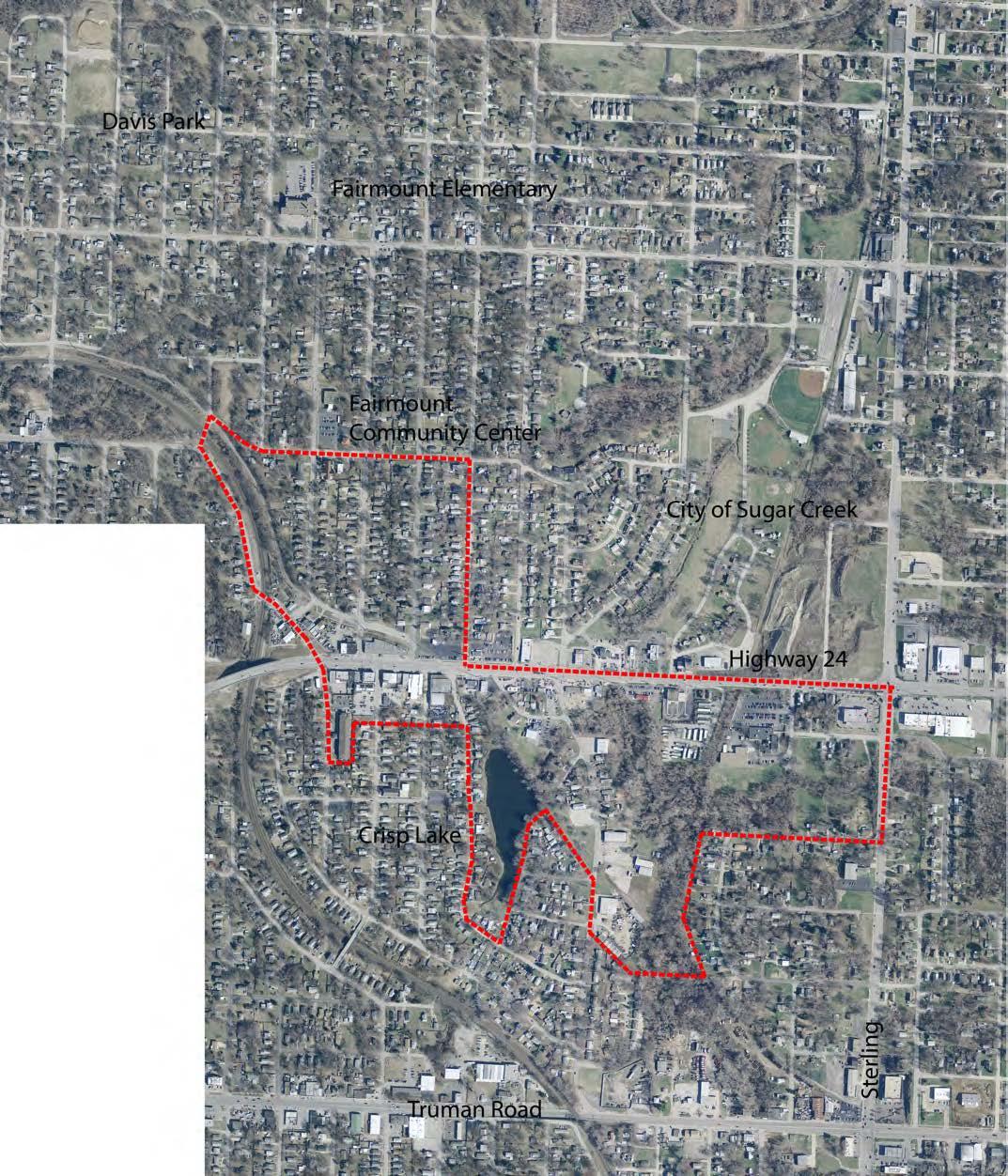
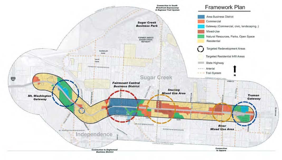
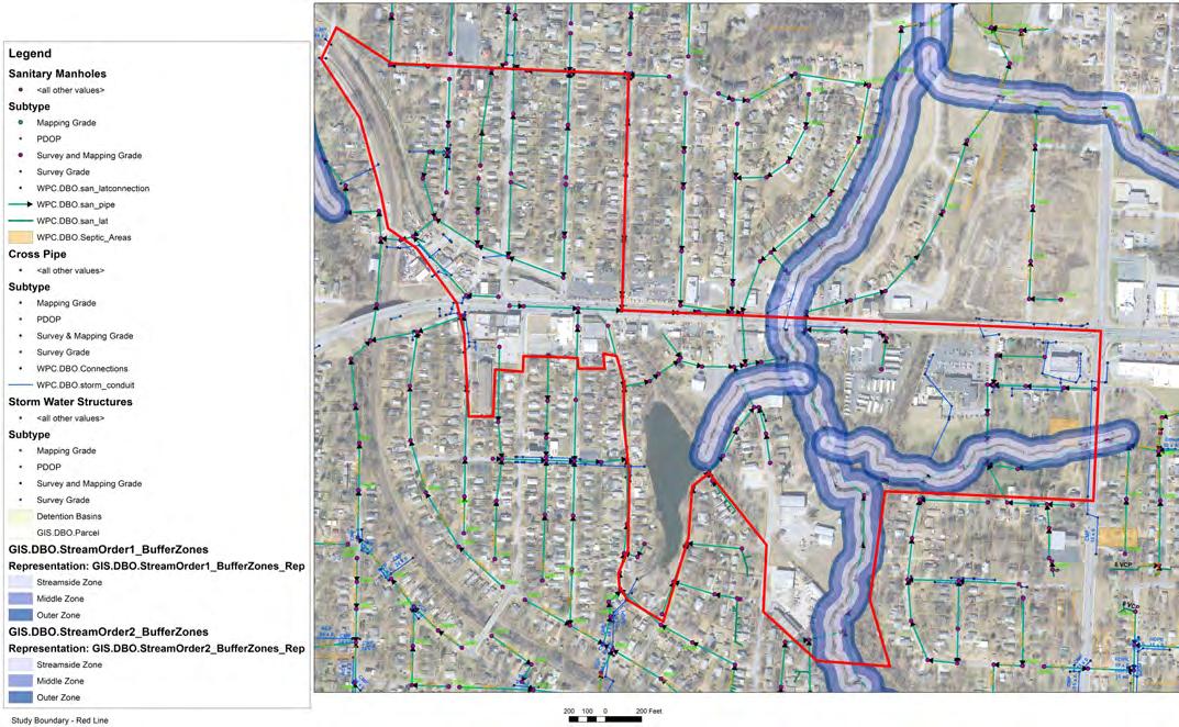
The project boundary includes some of the adjacent community north and south of US-24 from S Sterling Avenue on the East to the Railroad on the West.
Adopted in 2006, the “U.S. 24 Highway Corridor Study” examines the revitalization of the US-24 corridor, the gateway to the Truman Presidential Library and Museum. The plan explores the housing and economic development potential of the area. The plan included a vision and planning objectives for the area that extended from the city limits on the west to Truman Library on the east.
The US-24 corridor will be an aesthetic and vibrant entryway into the City of Independence through complementary land uses, safe neighborhoods, renewed commercial centers, and a healthy economy. The Fairmount District, a symbol of regional pride, will be transformed into a model for other commercial centers in the Corridor.
Interestingly, the vision for the area has specific focus on the Fairmount District and specifically the desire for more economic vitality within a “Business District.” After 10+ years, this district has not met the desires of the 2006 master plan. Additional thought and consideration is needed to spur private investment and rejuvenate this district.
The “U.S. 24 Highway Corridor Study” summarized its recommendations under the following 5 categories:
• The Economy
• Neighborhoods, Housing and Community
• Infrastructure and Transportation
• Natural Resources
• Implementation
This plan looked at all of the previous planning objectives
with focus on a few of the categories including transportation, natural resources and implementation.
Some of the objectives have been started over the past eleven years such as:
• Property repair and proactive code enforcement
• Establish a 353 Tax Abatement Program
• Create higher value education system
• Address the state of obsolete home construction standards
Some of the objectives are potentially not applicable in 2017 such as:
• Amended TIF Plan
Some of the objectives are still valid and need work such as:
• Enhance and diversify the corridor’s housing stock
• Infill development with diversity of size/types of housing
• Provide increased availability of retail services
• Create dynamic mixed-use urban centers, specifically in Fairmount
• Incorporate open space & recreation into the corridor
• Intergovernmental coordination (with Sugar Creek)
• Upgrade neighborhood streets and parks
• Streetscape improvements in Fairmount with sidewalks connecting residential
• Creation of City gateways
• Upgrade neighborhood street
It was stated in the 2006 corridor study that most busi-
nesses depend on automobile traffic along the US-24 corridor and have suffered as other corridors compete for dominance. A lack of large parcels, limited parcel depth, lack of infrastructure (such as sidewalks), and poor aesthetics have hindered redevelopment. This still exists in 2017.
 U.S. 24 Highway Corridor Study, © EDAW
The project began in March of 2017. CFS Engineers was selected to lead the design efforts. Over the 8-month planning process, data collection, analysis, concept generation, public engagement, Neighborhood owner conversations, planning recommendations, finance recommendations and implementation project identification were completed. The project was completed in October with Final Plan presentation in November 2017.
CITY

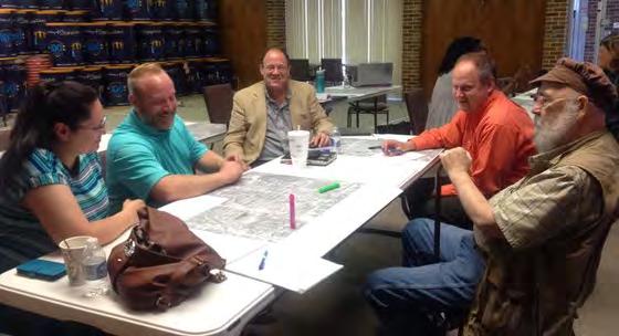
The CFS Team received input from multiple sources during the research, engagement, and design phases of this master planning effort. An ongoing public input process has solicited public comment from many participants on both existing conditions and conceptual design within the corridor. A Stakeholder Committee of local citizens, neighborhood leaders, religious and school district leaders, City staff, MARC, MoDOT and KCATA volunteered their time to assist with project leadership. They assisted with public/citizen engagement and conceptual plan review meetings. Their efforts helped to guide the research necessary to produce a design that takes into account the complex technical aspects of the district’s planning.
MARC City of Independence MoDOT KCATA
Reconnect ... through a safe, walkable environment through improved transit opportunities, getting people to jobs
Restore ... the sense of being a neighborhood
Enhance ... the public realm cultural diversity with a focus on locally-owned, neighborhood scale businesses
Encourage ... a family-friendly environment a thriving business environment
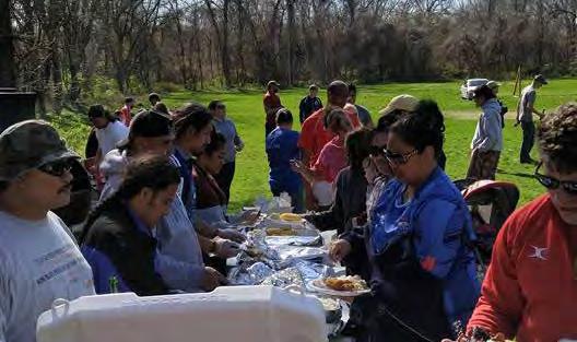
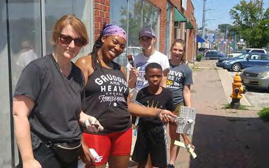
The Fairmount planning process began with intensive data gathering, analysis of existing conditions and many conversations with stakeholders. A pre-concept visioning process delved into the fundamental topics that are critical to defining the future of the US-24 corridor. What should be preserved and celebrated? What needs to change and evolve for the corridor to be successful in the future? A combination of technical understanding and deep insight from community members, property owners, businesses, and others helped to shape a conceptual design. Design concepts were vetted and refined to craft the recommendations found in the plan. Engagement was critical throughout the process to ensure that the final plan reflects the community’s needs and aspirations.
Below is a summary of stakeholder conversations that have occurred with City staff, property and business owners along US-24.
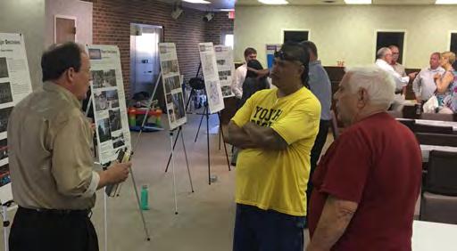
Two public meetings were held throughout the process - June and August 2017. The meetings brought together stakeholders, City leaders, representatives from Sugar Creek, and the general public to learn about the project and participate in an interactive dialogue about the future of the corridor. The second public meeting showcased the overall vision for the corridor, specific creative opportunities and potential site amenities.
The project team worked diligently to reach out and develop a collaborative partnership with organizations and institutions with a stake in the US-24 corridor, as a method to share knowledge, inform the planning process, and build advocacy and momentum for successful implementation.
The project team met with the Public Works Director, City Engineer, Parks and Recreation Director, Assistant City Managers, and representatives of Water Pollution Control to provide detailed insight to many topics including bicycle connectivity, traffic discussion, and flooding investigation.
A team of project stakeholders, property owners and City staff met on five occasions throughout the project to discuss the project, review the planning process and provide input to the direction of the master plan.
Two meetings were held at MoDOT to discuss the opportunities for the roadway. They were not in favor of a road diet, a change from 4 total lanes to 3 total lanes using a center turn lane, within the Fairmount corridor, but were friendly towards many design ideas associated with traffic calming, traffic signal modifications, access management, and financing.
Representatives of City Council attended the stakeholder meetings and public meetings providing guidance for the project, helping to identify key issues and representing all key interests and groups to ensure that the process is truly inclusive. A final presentation to the full City Council is scheduled in November.
“We are different now than a “Business District.” Fairmount business district doesn’t exist anymore. We need a different Theme, such as Cultural District or Fairmount Neighborhood.”
“We need to keep Fairmount a Cultural District with a lot of colors to create visual appeal.
“We need to embrace what other cities are doing merging social life with retail.”
“Engage activities that help us build businesses.”
“Support unique and creative businesses by locals.”
“Don’t focus on what we were but what we are now. We can’t maintain what we’ve done for the last 25 years. Most people go to Independence Ave to shop.”
“Predominantly a driving oriented environment. Fairmount has become a pass through. There is no incentive to stop.”
“Where there is no market we will create one.”
“I’m concerned about traffic.”
“Minimize angled parking and offer parallel parking or parking behind the building. This encourages people to walk around. I’d love to see walkways.”
“I don’t feel comfortable walking down the street. We need better sidewalks, the traffic is too fast and too close.”
“Many trucks come through here at 50mph. The 25 mph speed limit is not enforced.”
“We couldn’t cross on US-24 without the traffic lights.”
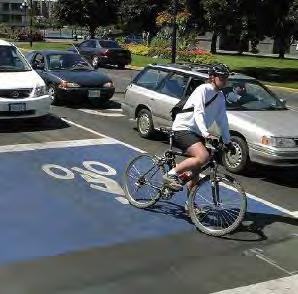
“Bicycle facilities could provide a pleasant experience along the highway”
“All sidewalks, doors and parding need to be ADA consideration”
“Wide sidewalks for large wheelchairs to be accomodated. Lots of curb cuts for wheelchair access. Flat non bumpy texture for the sidewalks”
“Do not take away my on-street parking without replacing them.”
“We need a community area visible tor US-24 traffic.”
“The corridor is not visually pleasing. We need greenery. I can’t see businesses thriving until there is better parking.”
“We need to find a community gathering spot.”
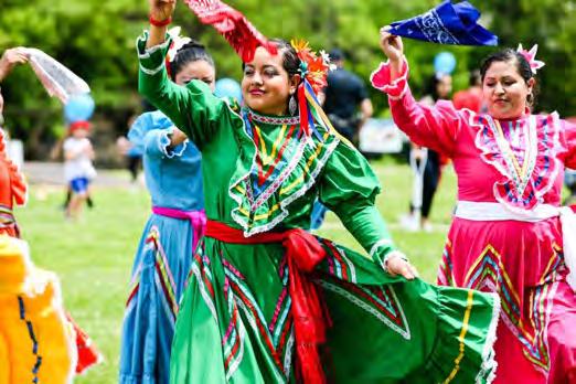
“Neighbors are outside and people are resourceful. We need to support the cultural diversity and uniqueness of the people here. Cultural should be a principle value.”
“We have to remediate the flooding issue before new development takes place”
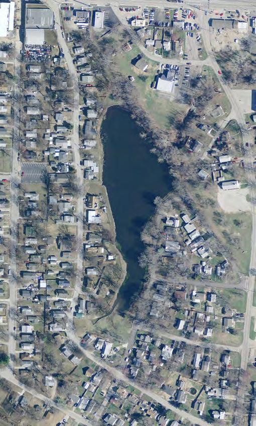
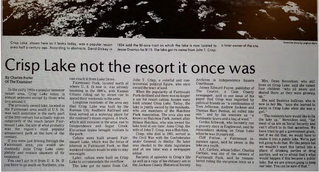
Crisp Lake - “It used to be a nice place to hang out, canoe and swim. It’s mostly green slime now.”
Crisp Lake - “The homes around Crisp Lake are deteriorating. Past flooding at the lake put 2 foot of water in my basement.”
Crisp Lake - “It would be great to enhance this lake area as a public amenity to the areas.”
Crisp Lake - There is public access on the south east side. However there is no parking. It’s not restricted just not as accessible.”
Landuse Goals
• Create public outdoor public space
(Enhance the public realm with opportunities for gathering / socializing)
• Enhance the sense of arrival
• Promote cultural diversity
(Develop a theme for the area as the Fairmount Community District or Cultural District of Independence - substituting the word “Business”)
• Promote family friendly community (Support neighborhood identity and diversity)
• Increase economic prosperity of the community with thriving businesses
(Focused on neighborhood scale commercial)
• Fix the flooding problem
• Preserve the historical value of Fairmount
Transportation Goals
• Safe and Comfortable Environment For Pedestrians
Wider,safer,cleaner, well-maintained sidewalks & crossings
• Access and Mobility for All Users
(Pedestrian, Bicyclist, Bus Rider, Elderly) Transit facilities, bicycle facilities, smoother traffic flow
• Supportive Environment for Existing and New Businesses
(Street as business front-door: give a reason to gather, linger, return)
• Creating a Destination that People Want to Visit and Stay
(Amenities, art, landscaping, landmarks)
• Connectivity to Surrounding Neighborhoods and Destinations
(Infrastructure on surrounding streets, direct connectivity to Fairmount)
• Parking Safety and Functionality
(The right amount of parking that works well in the right places)
• Visual Appeal and Cleanliness
(Repair and upgrade infrastructure)
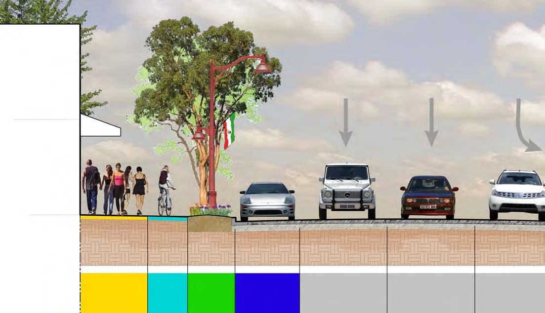
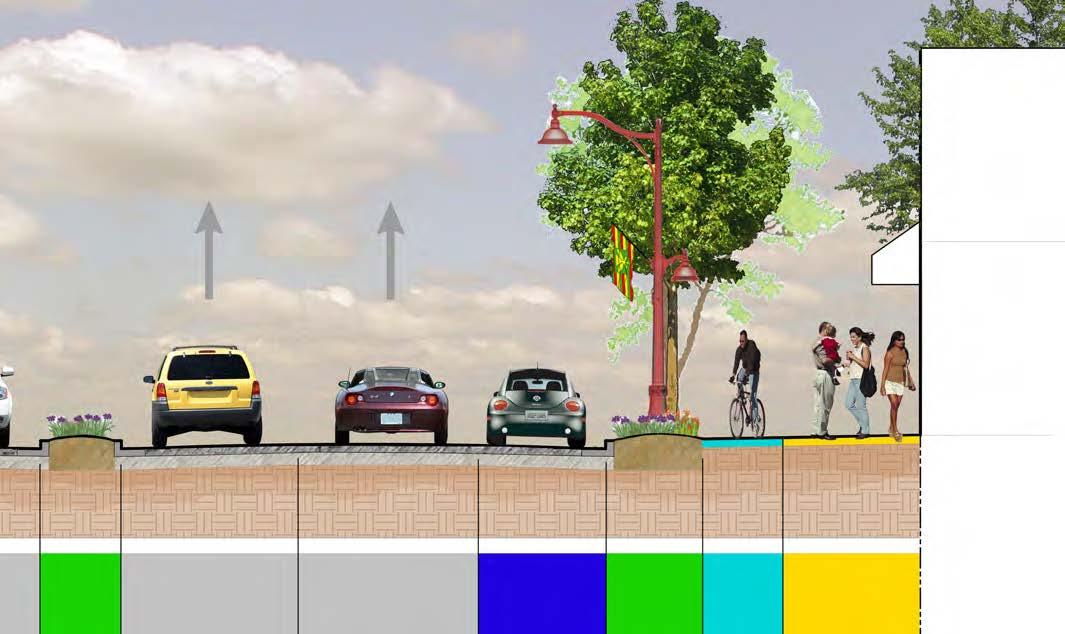
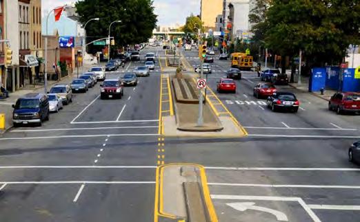
Design of the US-24 will include a five lane road configuration, with two travel lanes in either direction and center turn lane to accommodate turning movements. The design will include sections of raised medians for increased landscaping throughout the corridor.
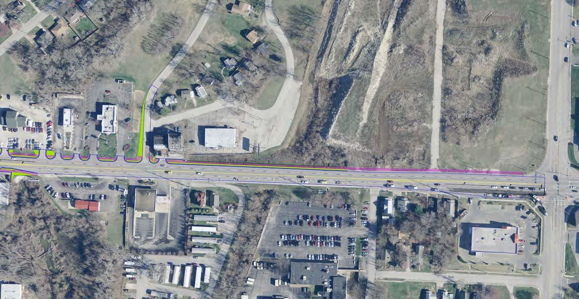
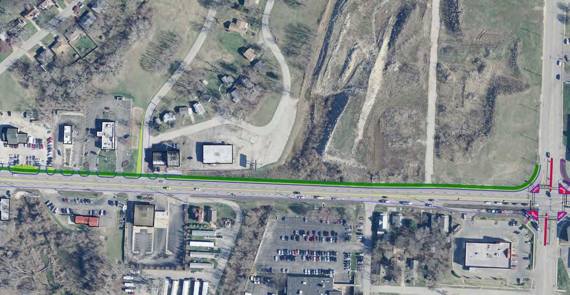
The area spanning from Northern Blvd to the railroad tracks on the west end of the project will be connected by a pedestrian promenade. Design of the corridor will accommodate comfortable movement of increased numbers of pedestrians, bicycle, and other non-transportation activities. Detailed requirements of the promenade are described within this plan.
The US-24 will be designed to accommodate a variety of streetscape amenities, including landscaping, pavement, lighting, signage, transportation infrastructure, furnishings, public art, and other features. Detailed criteria of amenities can be found within this plan.
A key purpose of the project is to strengthen and grow the economic vitality of the Fairmount District attracting a greater number and mix of visitors. Toward this end, the corridor design will include a variety of unique cultural destinations, sights, and activities that are specifically designed to enhance the Fairmount experience.
The US-24 will be designed to accommodate increased bus services along the corridor with specific far side transit stops at the intersection of Ash and US-24. Accommodations will include designated pullout stops in coordination with signalized pedestrian crossings.
Wayfinding signage, banners, new landscaping and roadway monuments will be designed for both pedestrian and automobiles to designate/delineate the rejuvenated Fairmount District.
The project area is about 3,600 feet long or 7,200 feet of street frontage. The three block area of pedestrian emphasis, also called The Fairmount District, which runs from the railroad bridge to S Northern Boulevard, is approximately 1,600 feet or a total 3,200 feet including both sides. For this three block area using both sides of the road, the street frontage is made up of 1,100 feet of intersections and driveways. This means that 35% of the pedestrian zone is divided by streets and driveways. For the total project area at 7,200 feet of street frontage both sides, the conflict distances equal approximately 2,600 feet or 37% of the total.
The design will seek to minimize pedestrian conflicts through the reduction of duplicate driveways, use of side street access, use of shared access between businesses, and reduction of driveway widths. This plan envisions the development of access management standards for future development, and encourages the continuation of case-by-case dialogue and negotiation with property owners for existing operations.
In addition to pedestrian and bicycle improvements, it is important to create 1) small pocket areas at intersection bumpouts and outdoor gathering/dining areas, but also perhaps more important 2) a large outdoor area, park and/or field areas for neighborhood festivals and outdoor gatherings.
To encourage better pedestrian movement, safety and economic development, the vehicular movement needs to be reduced to the posted 25 MPH. There are many techniques to encourage speeds to be reduced. The plan include many components including 11-foot wide drive lanes, landscape medians, street trees and vertical elements, roundabout, radar speed signs, and continued police enforcement.
The City of Independence has a rich history as a vital stop for merchants heading westward on the Santa Fe, California or Oregon Trails. The Fairmount District owes its origin, in part, to the Metropolitan Railway Company which provided service to the Business District and the Fairmount Amusement Park in the late 1800s and early 1900s. The Business District was once a source of civic pride and community identity. The district functioned as the town center with a trolley stop bringing visitors to the area. The area enjoyed enormous prosperity serving destinations such as the Mt. Washington and Fair-mount Amusement Parks.
In the most recent decades, however, progress gave sole dominance to the personal vehicle. Today trails, trolleys, buses, and even sidewalks are almost absent on several segments of the Corridor. Furthermore, US-24 and its arterials are designed as highways, not as city streets. This designation makes them difficult to cross, and not supportive of pedestrian activities.
The area consists of several blocks of one to two story buildings, some with distinctive architectural characteristics. The increase in strip commercial and new commercial areas, accompanied by decreasing population and housing conditions has reduced the area’s vibrancy. Traditionally, locally serving commercial uses were located on the first floor and office uses on the second. Over time, office use declined, leaving many areas vacant. Use has transitioned from neighborhood services to new tenants seeking inexpensive rents, such as thrift stores. Adjacent uses such as light industrial areas and used car dealerships often conflict with neighborhood serving commercial uses.
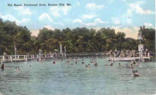
 Historic Photos of Fairmount and Images From This Engaged / Family-Friendly Community
Within and adjacent to the Fairmount District are drainage and naturalized areas. As shown here, Sugar Creek has a large floodplain area. The stream corridors are habitats and travel corridors for wildlife species including white-tailed deer and wild turkey. These natural areas serve multiple functions including the conservation of riparian (stream-related) habitat, stabilization of stream banks, preservation of historic landscapes, protection of water quality, and the provision of suitable land for trail development.
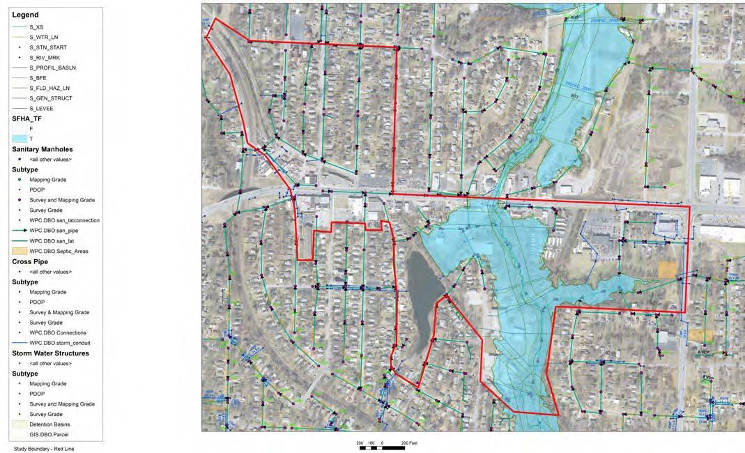
The protection of floodplains is a high priority for the City of Independence. The floodplain along Sugar Creek bisects the project area. The State of Missouri is a participant in the National Flood Insurance Program (NFIP). The developments located within the flood hazard area typically require flood insurance. If future development is desired, a flood development permit from the State Emergency Management Agency (SEMA) would be required.
The City’s Water Pollution Control Department has documented the locations of Stream Buffer areas along the natural creeks and regulates development setback distances. The intent is to encourage the integration of green concepts and watershed management strategies into the City’s day to day stormwater program operations. This local ordinance enabled the City to bring the concepts of water quality, ecosystem protection and responsible development practices together for the betterment of the numerous streams that flow through the City. Shown below is the stream buffer setback along Sugar Creek.
The Federal Emergency Management Agency manages programs to assist communities in buyouts of properties that are to be set aside from future development and are restricted to only public activities or use as open space. The City of Independence might consider taking advantage of these programs and purchasing property in the flood prone areas along Sugar Creek. In addition, the City could consider the land bank program to leverage dollars in the creation of a wetland bank for the benefit of future projects.
Stream Buffer Setbacks US -24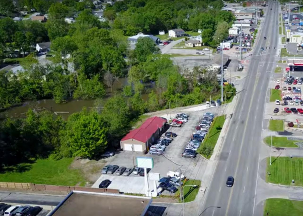
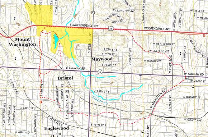
The Sugar Creek watershed crossing US-24 is fairly large at approximately 950 acres and the watershed to Crisp Lake is approximately 68 acres. Shown in yellow is the project study area. The dashed red lines represent the boundaries of each watershed.
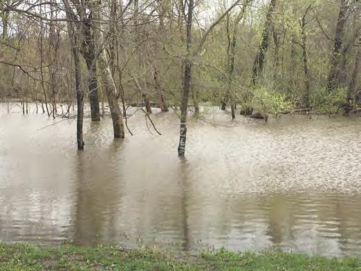
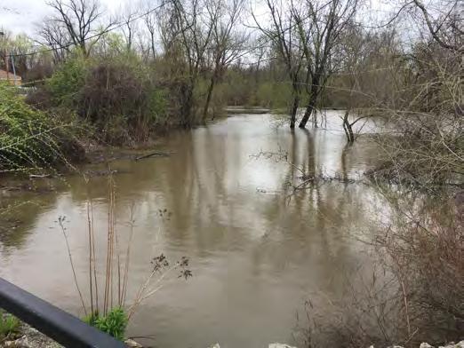
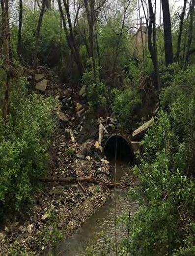
Since about 2012, flooding south of US-24 has become a more regular occurrence due to structural failures in the existing drainage culvert at US-24. Interviews with city staff from both Independence and Sugar Creek indicated that the existing 8’ x 10’ RCB culvert below US-24 underwent some inadvertent capacity changes in July of 2012 when a property owner on the northern side of US24 experienced pavement failure caused by undermining due to a ceiling wash-out in the existing culvert. To repair the sinking pavement, the property owner had several loads of gravel poured into the sinkhole, which had the negative effect of filling-in the culvert and blocking the cross-sectional flow area. As a result, the culvert was blocked causing the ground along Sugar Creek upstream of the culvert to flood. Local residents said that before the culvert was blocked, they had never seen flooding in this area since the 1950’s. Three existing businesses on the southern side of US-24, including a car wash, a liquor store and a used car lot, have experienced flood damage due to increased headwater depth caused by the blocked culvert.
The issue is further complicated due to the culvert’s location and the change in jurisdictions on the structure between the City of Independence on the south side of the highway, MoDOT within the highway’s right-of-way limits, and the City of Sugar Creek on the northern side of the highway.
Legal council from Independence, Sugar Creek, MoDOT and the private property owner have met, but nothing has been resolved in alleviating the flooding and clearing-out and repairing the Sugar Creek culvert. At the time of this master plan, the City of Sugar Creek has a pending lawsuit to investigate the problem.
Crisp Lake is an important natural, recreational and cultural amenity. The lake was originally formed in the late 1800’s as a watering reservoir for steam locomotives. (Pieces of the old railroad tracks are still present along the dam.) Later the lake was reverted to recreational use with cabin style housing being built around it for vacationing.
The presence of this lake provides numerous opportunities. A trail connection along an old railroad bed from the Fairmount District and Sugar Creek could connect to a new park on the lake. The history of The Fairmount District and previous Fairmount Amusement Park could be interpreted along this trail. Redevelopment of the areas near the lake would also provide a mix of new housing choices attracting new families into the area.
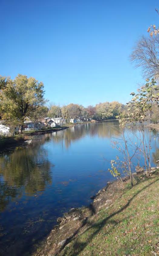
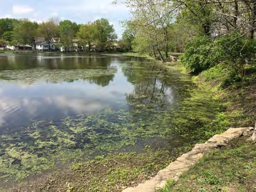
Crisp lake has been silted in over the years and during the summer months, the pond is full of algae as shown below. It is “Not the Resort” it used to be as documented in a 1980 Independence Examiner report.
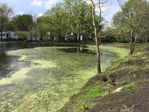 Photos from April 2017
April 24, 1980, Independence Examiner
Photos from April 2017
April 24, 1980, Independence Examiner
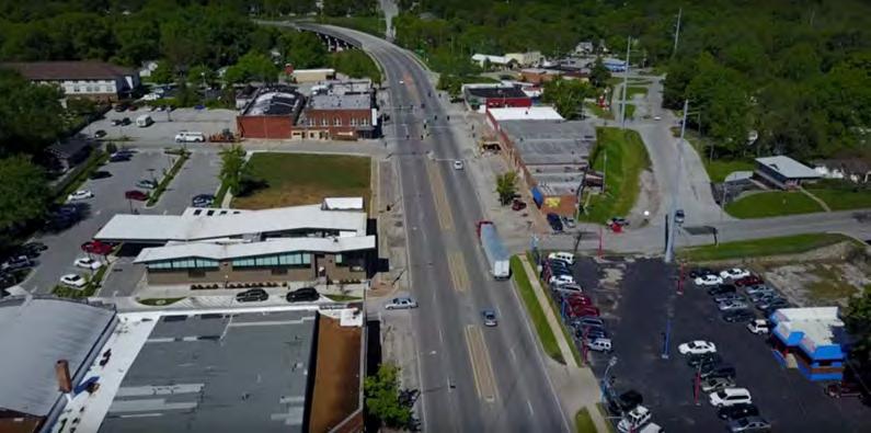
US-24 is currently five lanes wide through The Fairmount District. Four lanes carry through traffic, while the center lane is either a concrete median or a left-turn lane. This number of lanes is designed to carry the thousands of vehicles that pass along the road every day, including a significant number of trucks and tractor-trailers.
On the eastern edge of the project area is Sterling Avenue, a major north-south route. Street standards in the City are based on the 1993 Comprehensive Plan Thoroughfare System. Some of the adjoining collector streets such as Huttig Avenue are not constructed to City design standards.
More lanes can present challenges to other road users. More lanes creates a wider space for a pedestrian to cross the road. Additional lanes can also increase the speed that motorists are likely to travel, creating a potentially dangerous situation for pedestrians or cyclists.
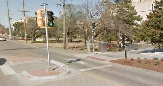
US-24 currently has a narrow concrete median at different locations along the corridor. The original intent of the median was to block specific left turn movements. The median is deteriorated and in some occasions, specifically at S. Hardy, S. Lake Drive and E 6th Street, driven around by west bound drivers. A median can serve as a safety device, but if a median is to be integrated into the long-term solution, it should be widened and the number of breaks minimized.
Left turning movements and pedestrian crossings on US24 are the two most important safety concerns identified by the public that need to be addressed with this project.
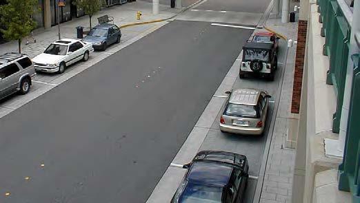
On-street parking is vital to the success of businesses within the 25 MPH zone of the corridor. Currently, there are both angled and parallel parking opportunities. Both options are acceptable. Angled parking takes up more developable space, provides more stalls within a short distance, and requires backing up movements to get into US-24.
One economic viability report notes that in a commercial district, each parking stall in front of a business is roughly equal $20,000 of sales per year.
Better off-street parking is also required to support current and future businesses, especially if the Fairmount District is going to continue to be a neighborhood center.
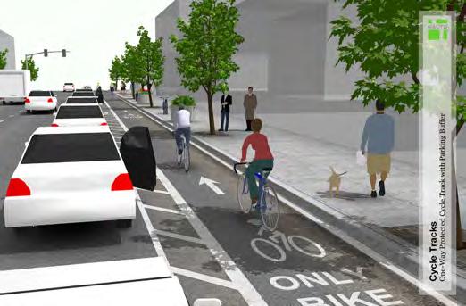
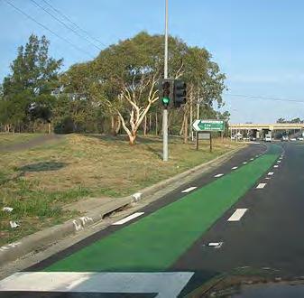
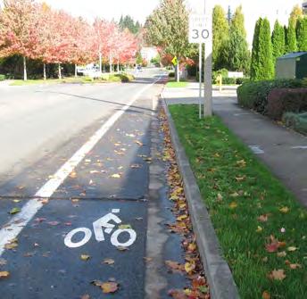
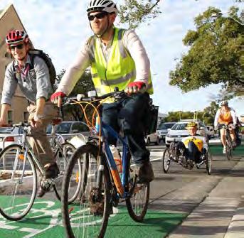
Protected bicycle lanes should be considered for the corridor. Protected bicycle facilities typically include a bicycle landing located between the roadway and pedestrian sidewalk protected by a curb, planters, onstreet parking or barrier. It can either be located at the roadway elevation or sidewalk elevation.
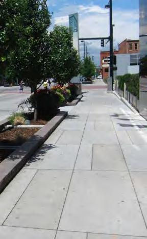
Wider sidewalks are also up for consideration in the corridor. This would allow for a more comfortable pedestrian experience, encourage social gatherings and support outdoor eating/cafe style seating.
CFS Engineers completed traffic counts at US-24 & Sterling Avenue in 2014, see figures to the right. An evaluation of the intersection was performed to determine intersection delay per vehicle and level-ofservice. The quality of traffic operation at an intersection is defined through level-of-service (LOS) which consists of assignments of ‘A’ for free-flowing conditions through ‘F’ for congested conditions. The procedures and methodology for determining the LOS are outlined in the Highway Capacity Manual (HCM 2010), produced by the Transportation Research Board. LOS ‘A’ through ‘C’ is considered acceptable. The results of the analysis showed:
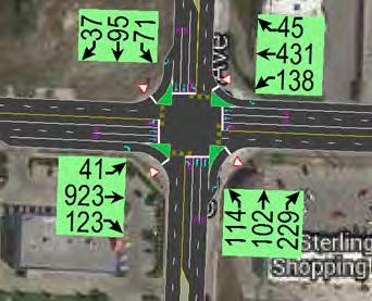
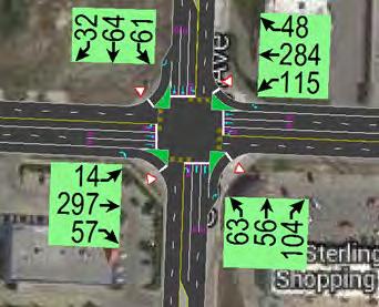
• For both of the two reporting periods, Saturday Peak Hour Traffic and PM Peak Hour traffic, a 28.6 sec delay on average for the intersection representing a Level of Service (LOS) of a “C “ rating.
• For expected increases in traffic the average delay will increase to a 32.5 sec delay on average for the intersection, also still receiving a LOS C rating.
The Average Annual Daily Traffic (AADT) for US-24 within the study area was 19,444 vehicles per day in 2015. This is down from ten years prior where the AADT exceeded 23,900 vehicles per day. As new commercial businesses are reintroduced into the area’s planned redevelopment, traffic volumes are expected to increase and capture pass-by traffic already utilizing US-24. The amount of new traffic will depend on the types of businesses which is unknown at this time.
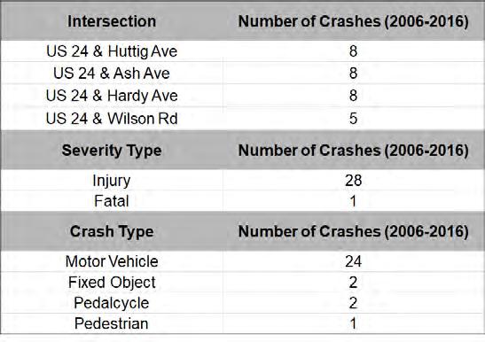
Roadway crashes is another significant issue with US-24. A high number of injury crashes is consist at each of the connecting side streets with a fatal crash occurring at US24 & Wilson Rd. The results of the past 10 years (2006 to 2016) of injury and fatal crash data is shown to the right. Two bicycle injuries and one pedestrian injury has occurred in the corridor. A thorough review of strategies to reduce the crash counts has been carried out and incorporated into the new concept design for US-24 in The Fairmount District.
 Saturday Peak Hour Traffic
Weekday PM Peak Hour Traffic
Saturday Peak Hour Traffic
Weekday PM Peak Hour Traffic
A number of attractions and other destinations are located near The Fairmount District. Changes to the transportation network could help improve connections to and from Fairmount and bring additional visitors to the district.
Different options exist for making multi-modal connections from Fairmount to other nearby destinations. Infrastructure changes could improve safety and comfort of traveling from the business district for motorists, bicyclists, and pedestrians alike.
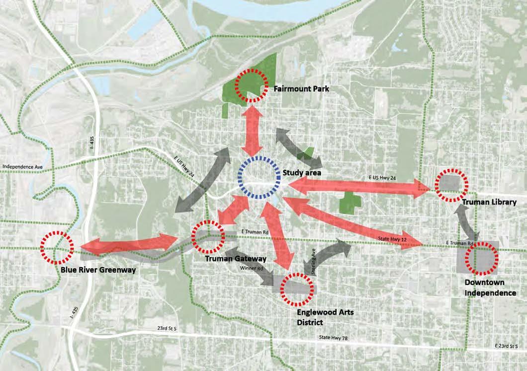
In addition, MARC’s Metrogreen Plan details a trail system that could connect the Corridor to a regional greenway system. The greenway system will build on the City’s onstreet trail system and the off-street trail. Transportation planning on US-24 is not new and a number of projects are proposed or underway to help address issues.
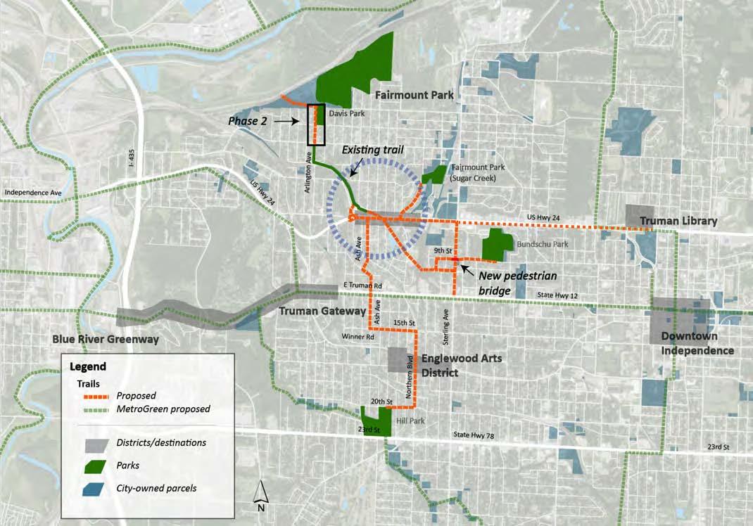
There are minimal park facilities in and around the Fairmount District especially since one of the local greenspaces, Hink Park, which is in the immediate area, will soon be incorporated into private land. Connected by an in-construction trail system from The Fairmount District to the north of the project area, Fairmount Park and Davis Park provide active recreation, ball fields, and playground opportunities. Bundschu Park, located on E 9th St to the east of Sterling Avenue, includes open space and active recreational areas. Recent investments in the Park have provided additional recreational amenities, such as a new playground, walking trails, mountain bike paths, and tennis courts for localresidents. Proposed connections to Bundschu Park include sidewalk and trail facilities with a pedestrian bridge over Sterling Avenue.
Throughout the process, a number of opportunities were identified and analyzed against neighborhood needs and desires. These opportunities provide the “building blocks” for meeting this master plan’s goals and implementation as the Framework Plan. These building blocks have the opportunity to improve the function, safety and visual quality of the corridor’s buildings, streets, and neighborhoods to positively affect the quality of life in the Fairmount District.
Corridor opportunities include:
• Underutilized land, especially commercial areas
• Areas already undergoing positive change, which is expected to continue
• Areas along corridors with frequent bus service that can accommodate development, especially areas with potential as pedestrian shopping districts
• Areas with special opportunities, such as where major public or private investments are planned
• Large parcels of vacant land
• Residential areas near existing commercial areas
• “Gateways” into the community
• Areas where additional density would be compatible
• Previously targeted redevelopment areas by groups such as the Northwest and Sugar Creek Community Development Corporations
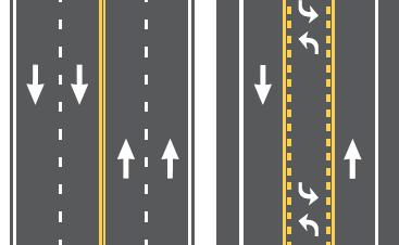
These two info graphics show some of the current standards for bicycle facilities and alignment of intersections with the safest turning movements. Pedestrian and bicycle safety are very important to the future implementation of this master plan. The top info graphic shows an option for a protected bikeway which was considered if the bicycle facilities stay at street elevation. The graphic also
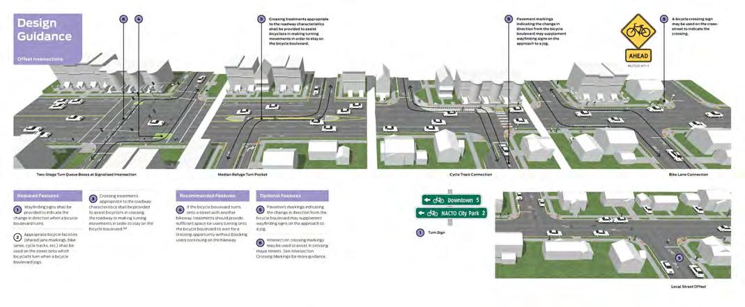
shows the importance of connection to intersections and moving behind bus shelters and protective bumbouts. The second info graphic discusses preferred ways for bicycles to cross roads. As the planning team evaluated the potential for bicycle crossings on US-24, the plan decided to create protected bicycle interestions with specific sstriping for a bicyce lane protected by curb bump outs.
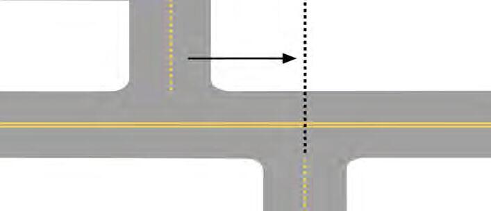
The following are two major decisions that need to be made regarding crossings and intersections.
The offset of intersections has caused many crashes over the last 10 years. Alignment from north to south across US-24 would create a safer environment for vehicles and pedestrians.
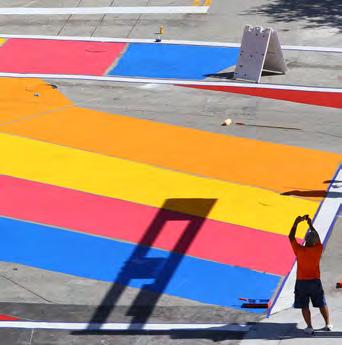
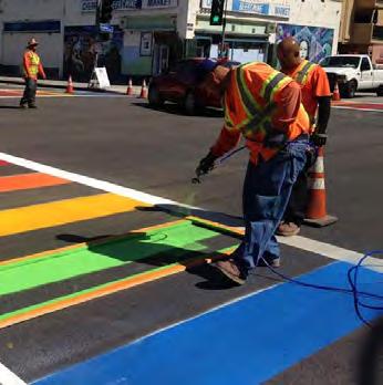
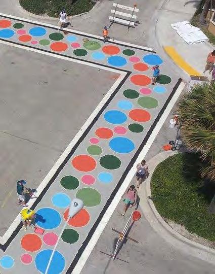
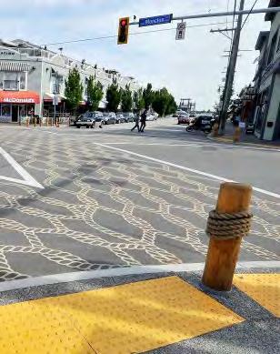
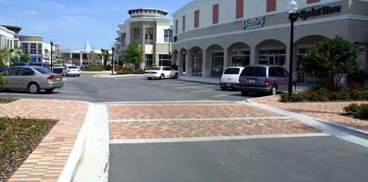
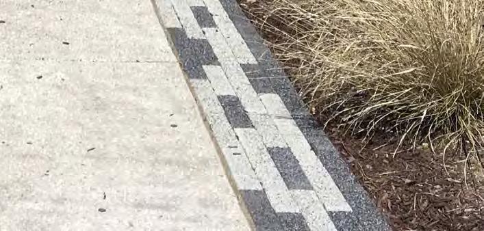
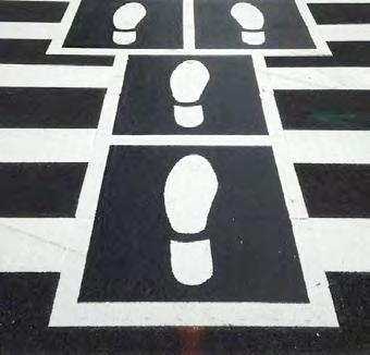
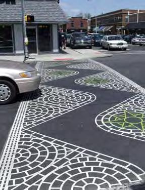
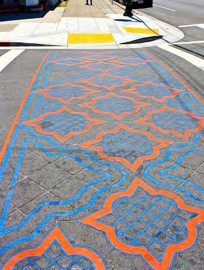
Images show pavement textures applied to crossings to reinforce pedestrian movements around a themed area.
The following are four major decisions that need to be made regarding street configuration.
More lanes can present challenges to other road users. More lanes creates a wider space for a pedestrian to cross the road. The current street configuration and lack of traffic calming tools lends itself to the existing speeding problem.
US-24 currently has a narrow concrete median at different locations along the corridor. The original intent of the median was to block specific left turn movements. A median can serve as a safety device, but if a median is to be integrated into the long-term solution, it should be widened and the number of breaks minimized. The median also serves as a pedestrian refuge area at road intersections.
On-street parking is vital to the success of businesses within the corridor. Currently, there are both angled and parallel parking opportunities. Both options are acceptable. Angled parking takes up more developable space, provides more stalls within a short distance, and requires backing up movements to get into US-24.
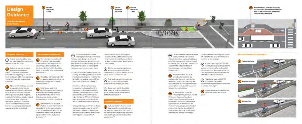
This graphic from the NACTO Standards shows how a protected bike facility should be built with appropriate buffer. It can either be located at the roadway elevation or sidewalk elevation. In general, a protected bicycle system is safer and more acceptable to families and riders of all abilities.
 Center Median Width and Number of Lanes
Santa Clara Valley Trans. Authority
NACTO
Federal Highway Administration Federal Highway Administration
Center Median Width and Number of Lanes
Santa Clara Valley Trans. Authority
NACTO
Federal Highway Administration Federal Highway Administration
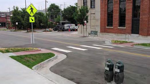
Community members identified traffic calming as a major concern and a significant challenge in creating a safe, comfortable, and inviting walking district. Vehicles travel significantly faster than the posted speed limit of 25 mph, street crossings are very wide, pedestrians are in close proximity to heavy traffic, and there are many driveways and other conflict points. To encourage vehicle speeds are driven closer to the marked 25 MPH, various traffic calming devices, lane configurations and design amenities can be used. This project will require thoughtful traffic calming strategies that work in close tandem with other project goals and constraints. Below are just a few tools that calm and manage car traffic.
Activated Speed Sign
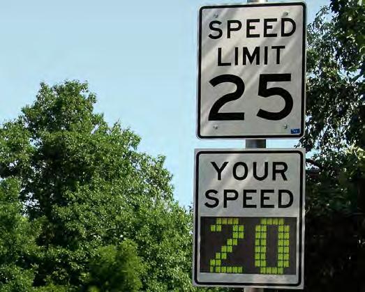
Cost: about $4,000 Each
Benefits:
• Reduces speed 1.4 mph on average
• Increases awareness of speeding behavior
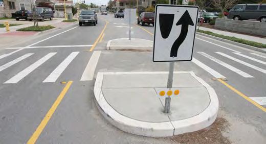
Pedestrian Safety Island
Cost: ranges from $15,000 -$60,000
Benefits:
• Pedestrians only have to worry about one traffic direction at a time
Pedestrian lights can be used to assist pedestrians crossing roadways.
Buildings close to the street create a sense of enclosure that prompts drivers to become more aware of their surroundings and to drive more carefully.
Cost: $8,000 - $12,000
Curb extensions expand the edge of a curb into a roadway. This space might be used for additional landscaping, wider sidewalks, and to create a “pinch point” that narrows the travel lane and prompts drivers to slow.
Benefits:
• Increases visibility of pedestrians wanting to cross
• Narrower road width
Raised Crosswalks
Cost: $4k-$8k
Raised crosswalks force car traffic to slow down, while creating a “pedestrianized” space across a roadway that gives pedestrians a higher priority.
Benefits:
• Reduces 36-39 mph to 24-27 mph
• Increases awareness for pedestrians
On-Street Parking
Cost: Low Cost
Benefits:
• Parking maneuvers slow through traffic
• Attracts customers for local businesses
Raised Intersections
Cost: $15k-$60k
• Creates “plaza” feel for intersection
• Speed reduction ≤ Raised crosswalks
Trees and other vertical features placed near the edge of a travel lane create the sense that the street is narrower than it really is, causing traffic to proceed more cautiously.
Signals can be located and timed so that average speed or high-end speeding along a road is reduced, and so that pedestrians and bicyclists can cross the street more easily.
Curves or curb extensions that narrow a roadway and shift the travel path calm traffic by forcing drivers to slow down and more carefully navigate the road.
Other Options Include:
• Landscape Median
• Overhead Archways / Structures
• Colorful Pedestrian Crossing Marking
• Monument Signage / Pole Mounted Banners
• Radar Enforcement
• Lane Narrowing
• “Watchman” Traffic Calming Sys.
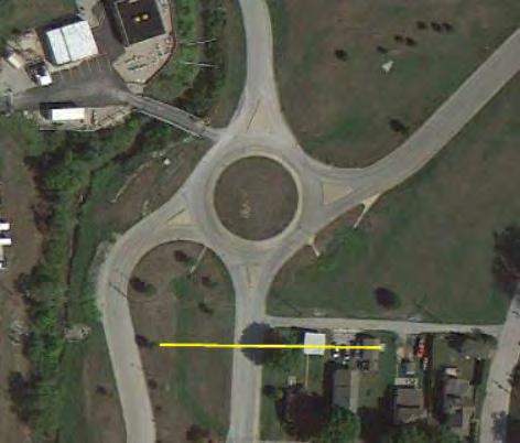
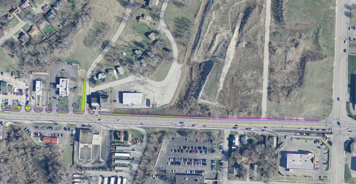
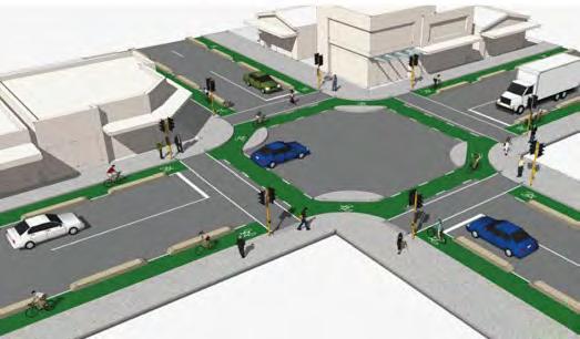
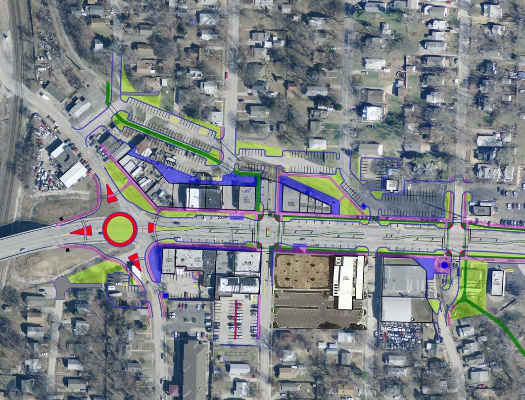
In discussions with MoDOT, a roundabout concept would be one of the best solutions to change the aggressive driving habits through The Fairmount District. The design of a roundabout at the intersection of US-24 and E Wilson Road is very important to traffic operations. Ultimately, the roundabout would provide increased safety by reducing crash conflict points, better access for north and southbound traffic and would reduce speeds to be consistent with the posted speed limit. Something to avoid would be a poorly designed roundabout as was the case in Sugar Creek at the intersection of Sterling Road and Standard Lane. That roundabout failed and was removed due to poor accommodation of approach lanes.”
Roundabout Concept - This image shows the approximate size of roundabout required to maintain 2 lanes of traffic either direction at 25 MPH. A roundabout is the best and most preferred traffic calming measure approved and supported by MoDOT for US-24.
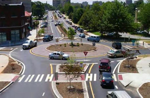
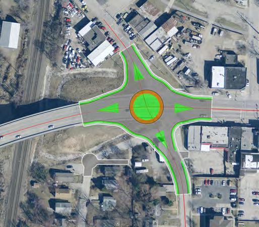
Roundabout Concept - This image shows the proposed roundabout with the Sugar Creek roundabout overlaid (represented with the dark gray). Note the enlarged access curves and angles with the Fairmount roundabout concept.
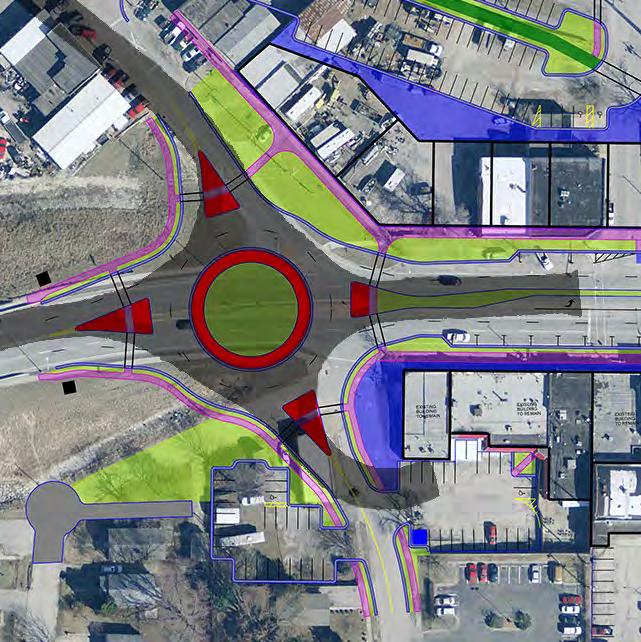
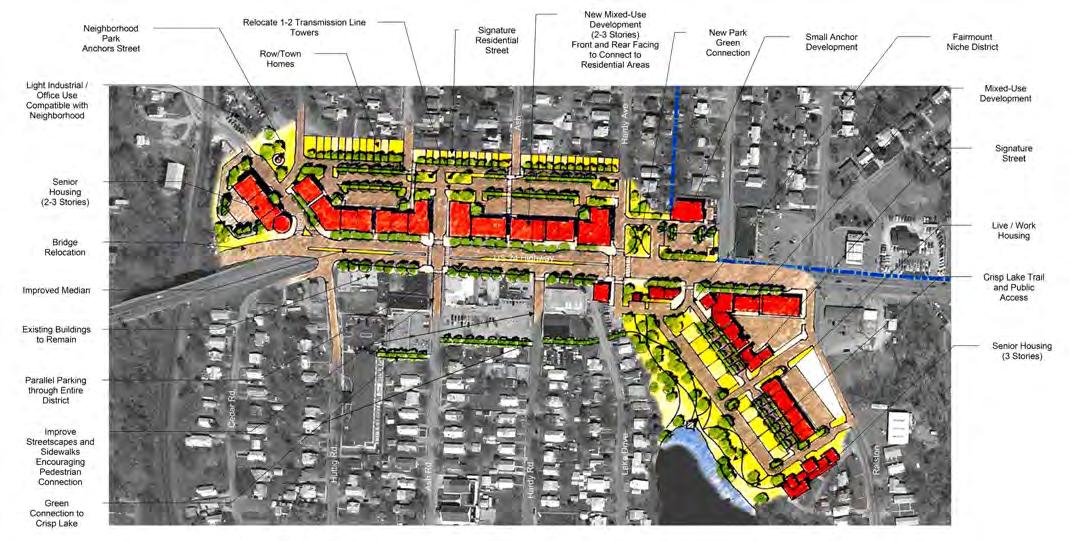
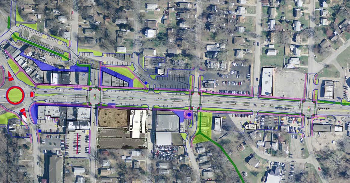
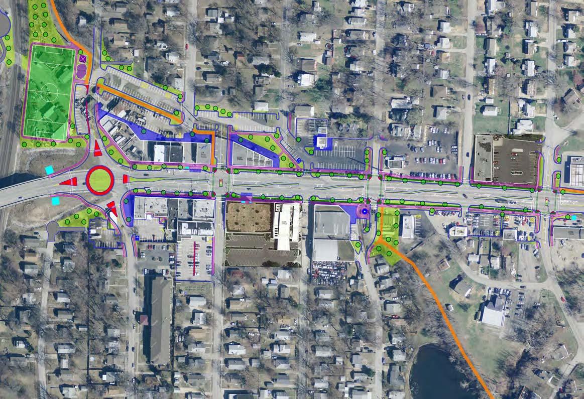
The master plan looked at opportunities for road alignment, access management, neighborhood parking, and public lands made available for public gathering locations / plazas.
(As Illustrated on the following page)
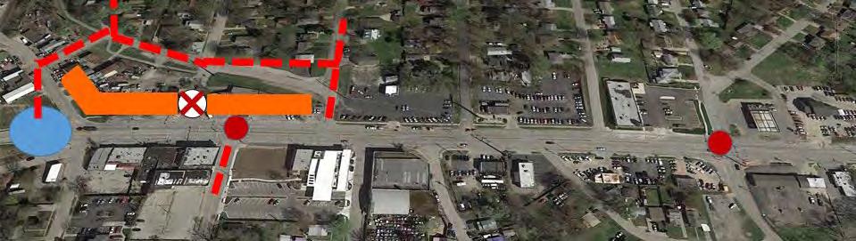
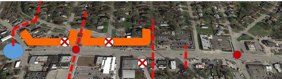
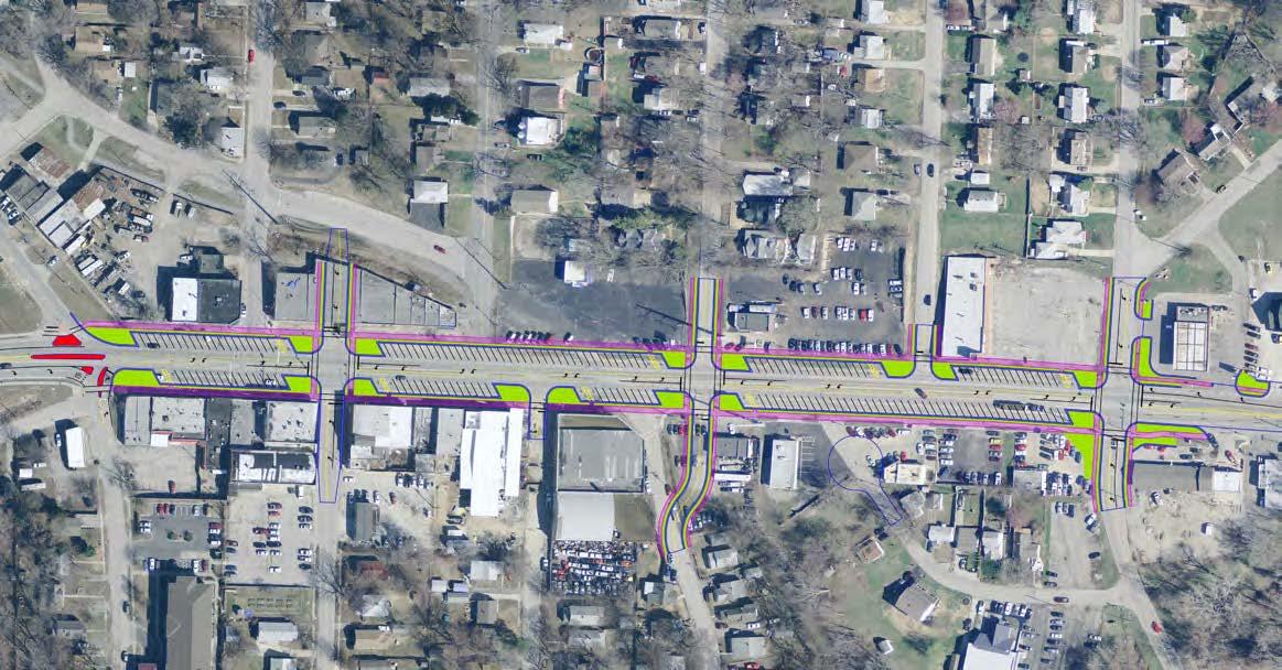
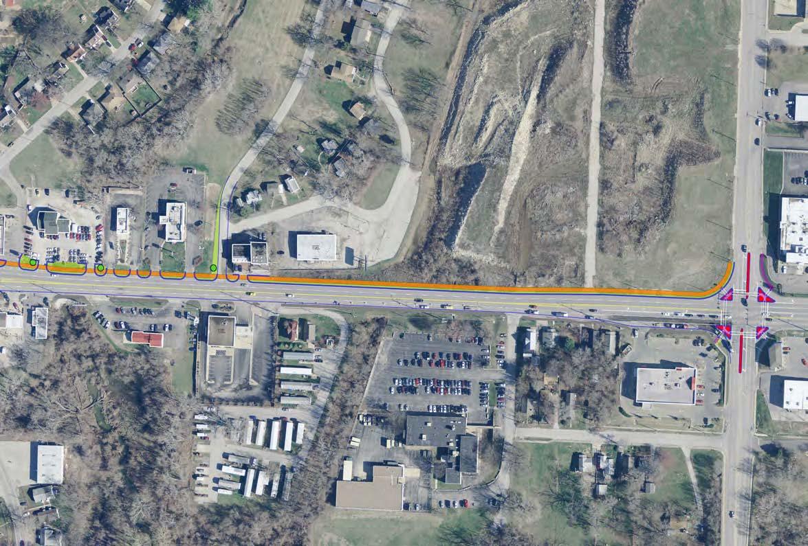
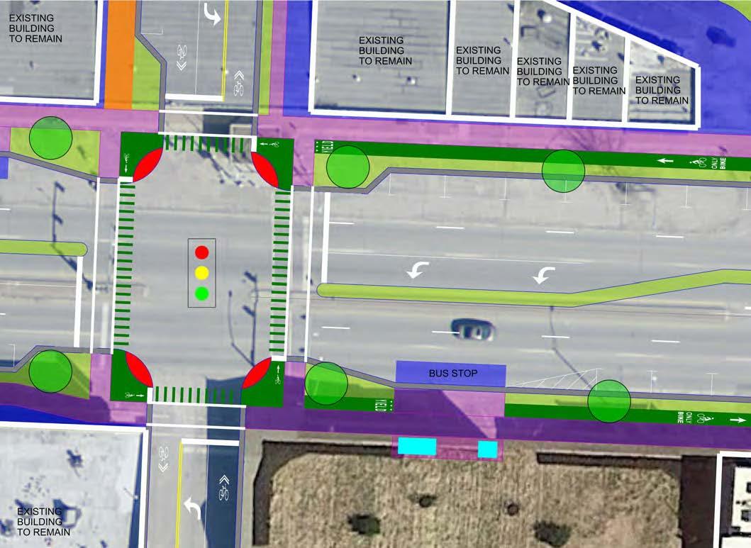
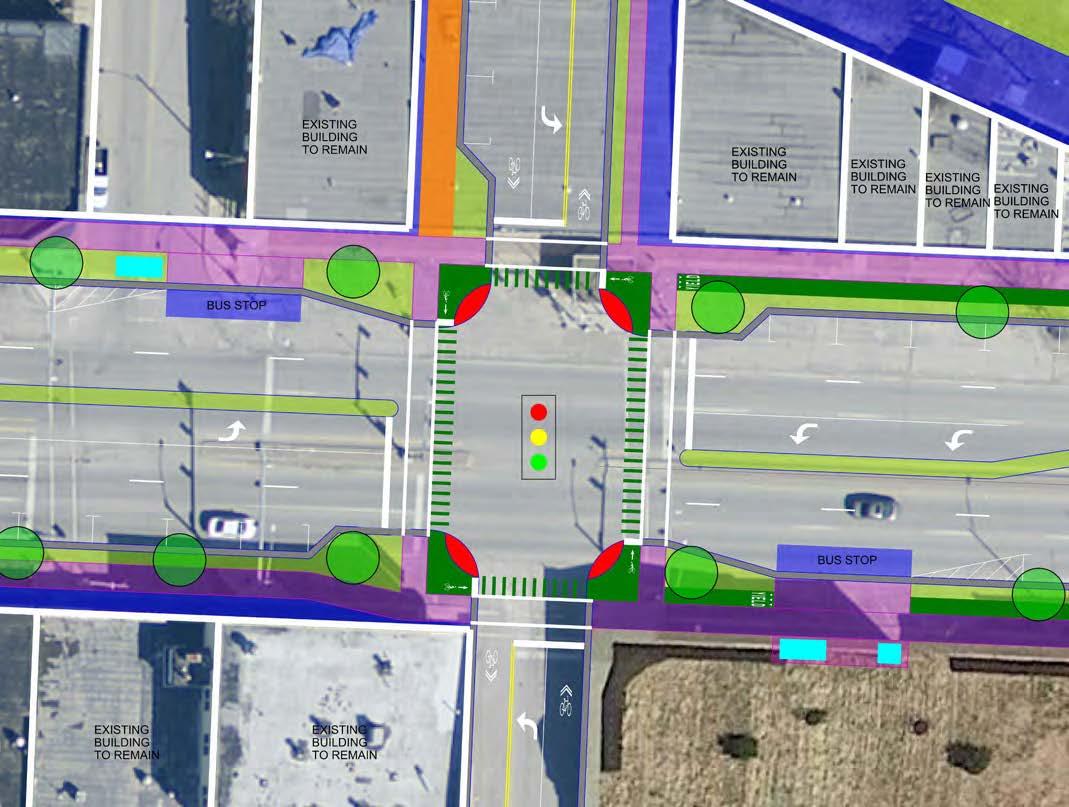
A. This is the side street configuration that most closely reflects the design ideas from the 2006 “U.S. Highway 24 Corridor Study.” The plan shows the removal of Huttig Ave, Alignment of Ash north/south with a new traffic light, Removal of S Huttig, and alignment of Lake Rd north/ south. This concept maintains 3 traffic lights (Shown as red dots) through the project area.
D. This side street configuration shows the addition of a roundabout at Wilson with direct connection to Cedar through a new development. Huttig Ave (north side) would be removed as well as both traffic lights in the heart of the Fairmount District. A pedestrian only light would be installed at Ash. The connection at Ash (north side) would be removed and Lake Road Aligned on both sides with a new traffic light added.
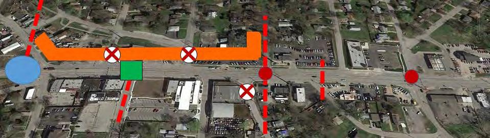
B. This side street configuration is a modification of the 2006 “U.S. Highway 24 Corridor Study” with the addition of a roundabout at Wilson. The plan shows the removal of Huttig Ave (north side) and Ash (north side) with a realignment of Lake Road. This concept removes 1 traffic light.
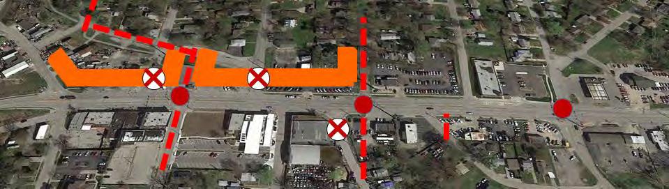
C. This side street configuration shows the addition of a roundabout at Wilson and the removal of Huttig Ave (north side) and its associated traffic light. A traffic light would remain at Ash.
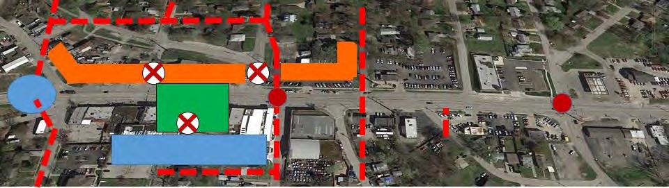
E. This side street configuration shows the addition of a roundabout at Wilson and removal of all side street connections in the business district [Huttig Ave (north side), Ash (north and south sides of US-24)]. S Hardy Avenue will be aligned to the north and a new traffic light installed. This opens up The Fairmount District for a large pedestrian crossing (“Pedestrian Scramble” or “Barnes Dance” all direction pedestrian crossing) and 3 community plazas where the previous roads were located. Similar to the parking layout, prior to the senior housing being constructed, we would make a large parking lot (shown in blue) with roadway connection between Ash and S Hardy Avenue.
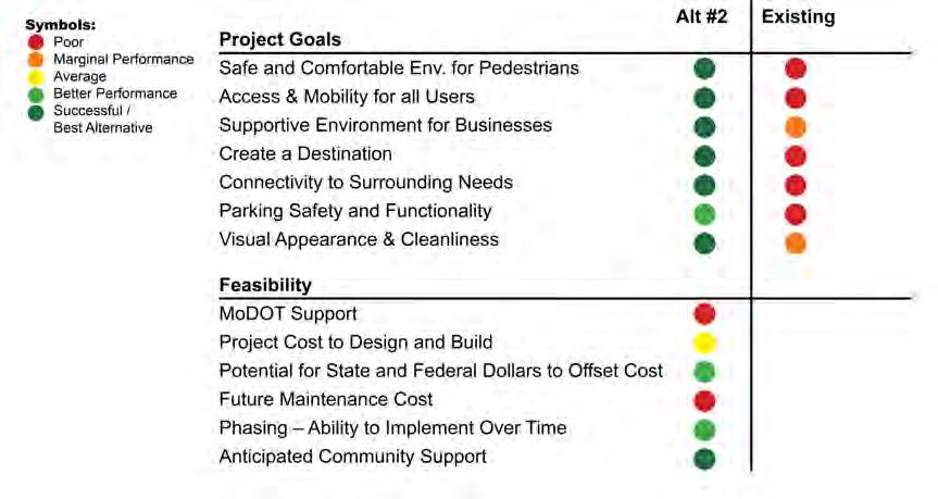
Corridor opportunities were used to create three planning scenarios. The Stakeholder Group and the public participated in an exercise to determine which theme resonated the best for them and The Fairmount District. The Neighborhood Center Concept was rated the highest and moved forward into master planning as shown on the following three site plan alternative designs.
This concept focuses on development of enhanced public spaces for social gatherings and cafe-style seating in the heart of the Fairmount District. Roads could be closed to create public environments for parking or plaza spaces. Wide sidewalks and onstreet parking would be emphasized with enhance pedestrian crossings. This concept would incorporate a road diet dropping a lane of traffic to one lane either direction and a center turn lane.
2 3
This concept provides basic improvements to the pedestrian environment installing wider sidewalk, ADA ramps, landscaping, pedestrian lights and re-stripping of parking stalls. The concept also provides basic improvements to the road network updating, but maintaining the existing concrete median. This concept could be the fastest to implement.
This concept focuses on the movement of all modes of travel including bicycle routes, bus stops, and vehicle movement through the corridor. This concept will connect bicycle routes along the corridor to local bicycle facilities and park surrounding the District. This concept includes a roundabout on the west at Wilson Street/S Huttig Ave. Parallel parking and wider landscaped median may or may not be included.
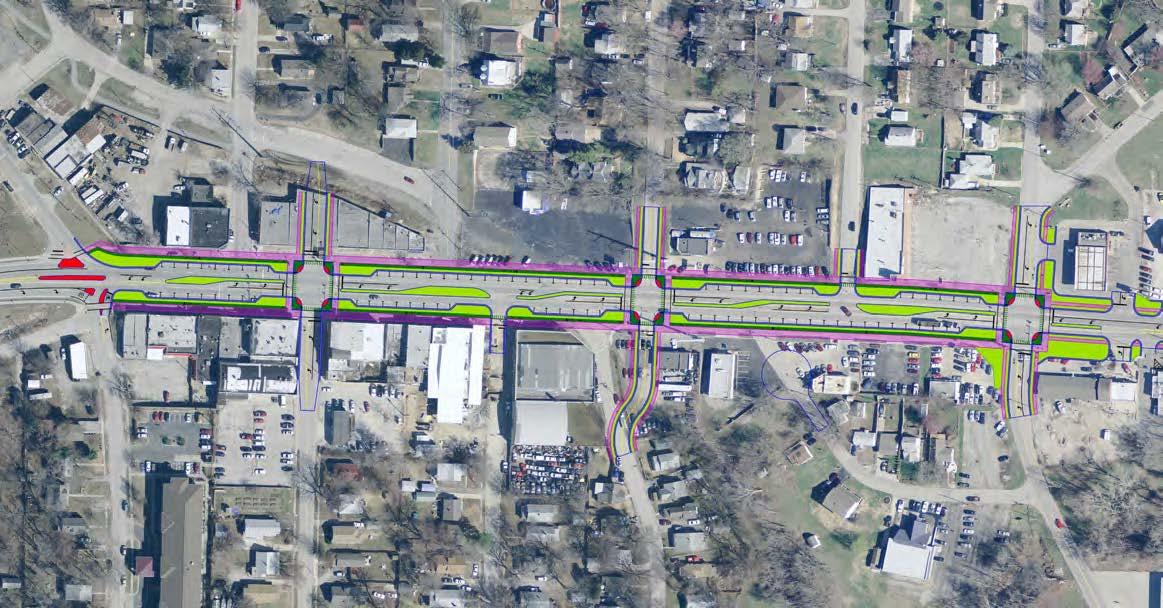
The following pages show the progression of these planning scenarios into three alternative site plan layouts.
Armour Road Similar with Angled Parking
Similar to Armour Road in North Kansas City, which was identified as a precedent study, additional angled parking could be integrated into the corridor for three blocks to improve parking and encourage adjacent commercial development.
+ Improves and increases business parking in the corridor
+ Fixes key sidewalk gaps and safety issues
+ Reconfigures road to calm traffic and reduce conflict points
+ Provides opportunities to enhance appearance and district identity
+ Feasible to implement incrementally
- Does not accommodate on-street bicycle and bus facilities
- Angled parking less safe than parallel parking
- Reduction of travel lanes limits overall traffic capacity of roadway
- Hard to get approved by MoDOT
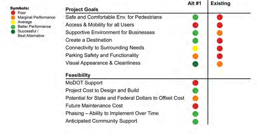
This alternative focuses on the pedestrian movement, removing a lane of traffic, providing on-street parallel parking, wide sidewalks and protected bicycle facilities throughout the corridor. A round-about is added for traffic calming and S Ash realigned.
+ Safely and comfortably accommodate all modes of travel
+ Reconfigures road to calm traffic and reduce conflict points
+ Provide opportunities to enhance appearance and district identity
+ Improves safety of parking
+ Feasible to implement incrementally
- Parallel parking means fewer on-street spaces overall
- Reduction of travel lanes limits overall traffic capacity of roadway
- Hard to get approved by MoDOT
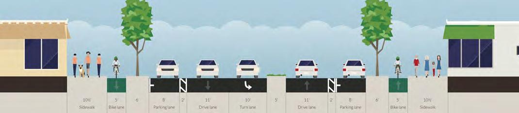
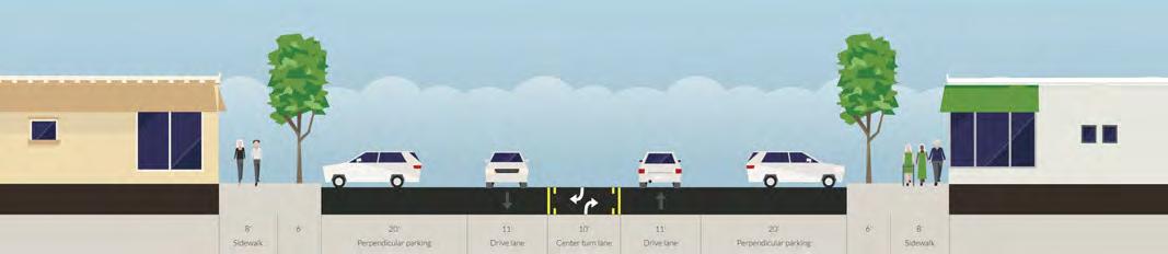
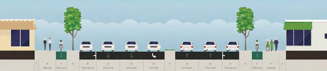
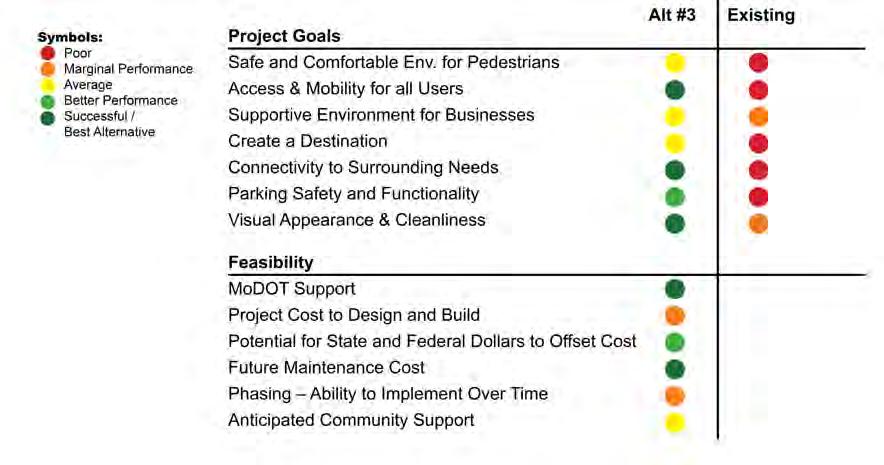
This concept maintains the existing five lanes of traffic and expands the right-of-way to building facade to building facade or about 115-120 feet wide. Landscaped areas, bicycle facilities and 8’ wide sidewalks are provided.
+ Safely and comfortably accommodates all modes of travel
+ Improves safety of parking
+ Maintains existing traffic capacity
- Requires center line shifting about 10’ to north which takes more time and resources to implement incrementally
- Roundabout required to address highway environment / speeds
- Typically multiple travel lanes mean faster traffic and less comfortable crossings
- Parallel parking means fewer on-street spaces overall
- Less space than other alternatives for public space, seating, and other public amenities
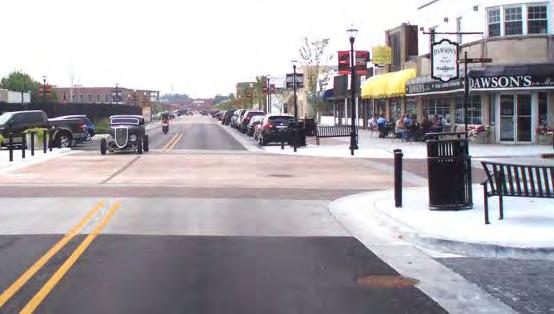
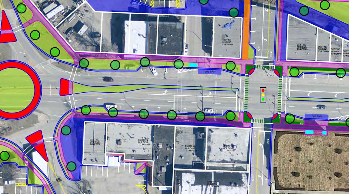
The Framework Plan identifies improvements to The Fairmount District that both enhances the function of the corridor and supports a pedestrian oriented environment. This chapter outlines the conceptual plan, describing both how the different components enhance the corridor as well as how different elements coordinate with each other. The following pages illustrate a conceptual framework that allows detailed design and engineering of corridor improvements to move forward with an understanding of the big picture.


Pedestrian activity is vital to the success of The Fairmount District. The District should be compact, walkable, and provide visual interest to both pedestrians and automobiles. The area will be serviced by an efficient multi-modal transportation system, including bus, foot and bicycle. To facilitate this, sidewalks will be improved along US-24 and streets leading to the District. The sidewalk and bicycle facilities link through the corridor and are extended southeast from Lake Road along the old railway bed linking to new public areas around Crisp Lake.
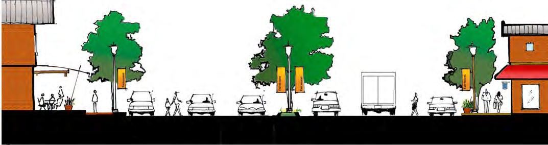
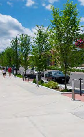
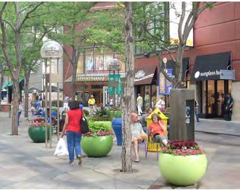
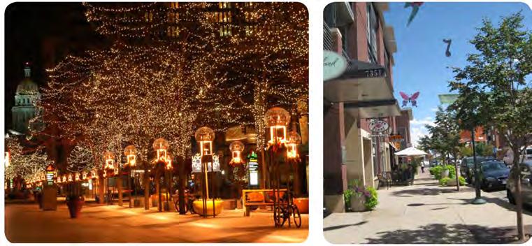
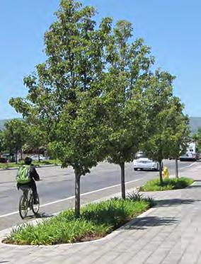
The three block length of The Fairmount District will be connected with a pedestrian promenade on each side of US-24. The promenade will be 8’ - 10’ wide, attractive, and comfortable, encouraging neighbors and visitors to walk to multiple destinations in the area.
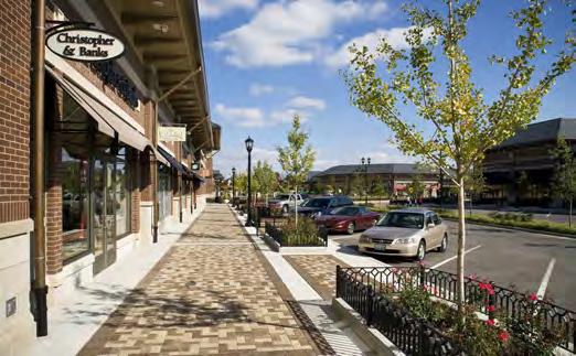
Pedestrian Experience. The design of streetscapes, parking lots, signage, and landscaping will provide a safe, dignified pedestrian shopping experience. If the land between a commercial building and parking area is hardsurfaced, the area must contain two or more pedestrian amenities such as benches, drinking fountains, planters, kiosks, public art, outdoor eating areas, vending space or other design elements
Landscaping. Shade trees, seasonal plantings, and “soft” spaces will be installed and maintained to mitigate the intensity of US-24 and summer climate, and to contribute to an attractive retail environment. New parallel parking will assist in protecting pedestrians.
Medians. Landscaped medians are improved and implemented west of S. Northern Blvd. This element is important to the overall design as a traffic calming device, point of refuge for pedestrian connectivity and enhance landscape beautification.
Beautification of the Corridor. An unusually high concentration of second-tier businesses, such as used auto dealerships, influences the look and image of the Corridor. The appearance of key areas along the Corridor would be improved through landscaping, sidewalks and other streetscape elements.
Incorporation of Public Spaces. New development and re-development opportunities will incorporate public spaces to create a prominent civic component in core commercial areas. A diversity of types and scale of public areas will ensure a wide range of pedestrian destinations throughout the District such as civic plazas, courtyards, fountains, pocket parks, art, and sidewalks. These public spaces will provide meeting and gathering points for people and will be within close proximity to work, shopping, civic, cultural, entertainment activities and activity centers.
Pedestrian Safety. Potential crashes at points of conflict among transportation choices (i.e., pedestrian crosswalks) will be reduced by changing the paving materials, enhancing traffic lights, parallel parking and utilizing access management techniques along US-24 Highway and arterial streets.
Public Safety. The design of buildings, parking areas and streets will provide a sense of security and safety for users. Adequate lighting, visibility and location of facilities collectively will add to a secure 24-hour environment for employees, tourists, and visitors. New parallel parking will assist in protecting pedestrians.
Access Management. The percentage of pedestrian conflict points was reduced from 35% in The Fairmount District to 22%. This could be accomplished by the reduction of duplicate driveways, use of side street access, use of shared access between businesses, and reduction of driveway widths.
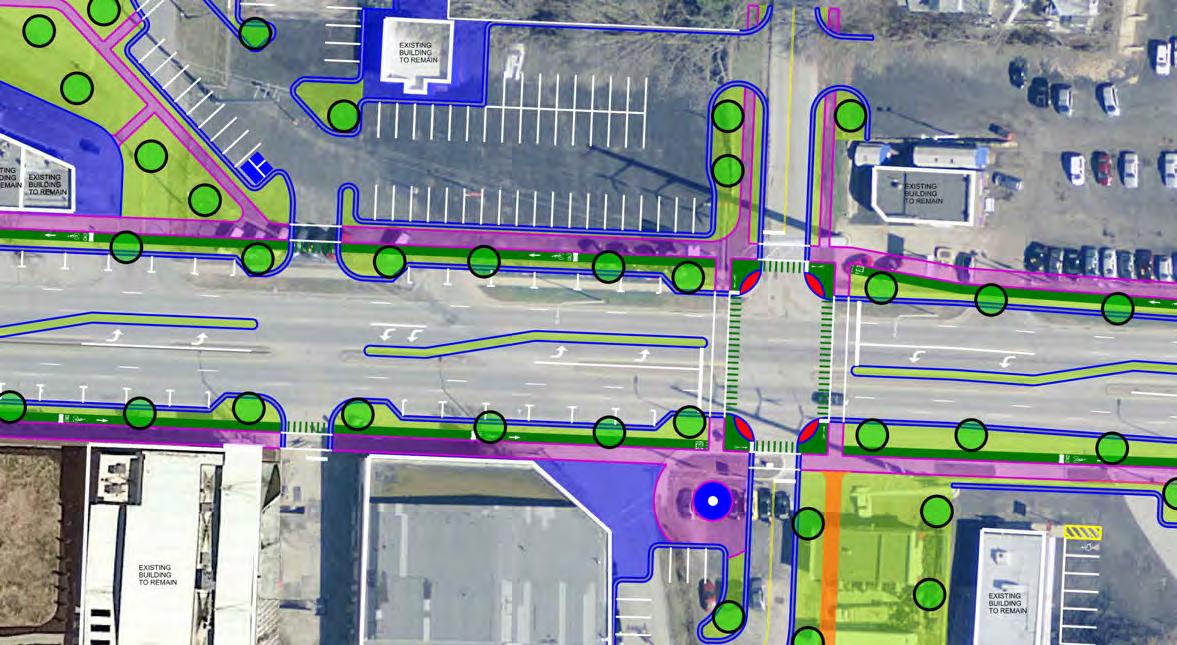 S Hardy Ave
S Lake Dr
S Hardy Ave
S Lake Dr
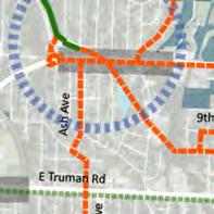
Regional bicycle connectivity is a key component to this project. Currently, the trail from the north/Fairmount park ends at the north side of the Fairmount District. The plan shows the path connected from the north to the new protected intersection at US-24. Shared on-road bicycle facilities can head south on S. Ash per the Parks and Recreation Master Plan. With the implementation of the US-24 plan, bicycle facilities are extended east to Sterling (and with FLAP funding perhaps to the Truman Librarysee Chapter 5 “Implementation”). Within the Fairmount District bicycle facilities will be protected behind curb facilities. At the new re-aligned S Lake Drive intersection, a new trail connection will be built along the Crisp Lake dam headed southeast toward proposed bicycle facilities on Truman Road.
The Framework Plan identifies potential locations for transit stops as far side stops of a new re-aligned S Ash Street. The stops will be designed to accommodate KCATA buses and associated shelters in a pullout out of traffic. As far side stops to the traffic signaled intersection, they can easily move back into traffic when the lights are red in the east/west orientation. Shown in blue are the two proposed bus stops and associated pavement parking/shelter pads.
In addition to the shelter, an outdoor musical instrument should be considered at the platform as a fun amenity for those in the area.
 Framework Plan enlargement showing the transit facilities in blue.
Key historic buildings on the south side of The Fairmount District will form the core of the rejuvenated Fairmount District. These buildings will be preserved and the facades restored and will provide a key connection to the history of the area. Other buildings in the corridor would be redeveloped with the improved pedestrian amenities and improvements to the vehicular circulation/parking.
New buildings which should be two to three story buildings will have ground floor retail and upper stories will accommodate residential apartments and office uses. These services will be designed to serve local residential neighborhoods and larger trade areas with small-size
specialty shops and services. Examples of neighborhoodbased businesses include restaurants, beauty salons, furniture and home furnishings, dry cleaners, apparel and accessories, book store, bike shop, physicians, lawyers, accountants, insurance, and financial services.
New uses will be unique and notable, with some uses encouraging people to visit at different times of the day. The area will serve as a foremost destination for neighborhood residents.
The District will be expanded to the north, south and east, to ensure that the area is large enough to be selfsupporting and be considered a destination by citizens of Independence and adjacent municipalities. Key nonresidential land uses such as auto dealerships and light industrial will need to be transitioned into complementary uses for the neighborhoods.
Infill and redevelopment in adjacent neighborhoods will grow a critical mass of population surrounding the corridor. Multi-family residential development will be encouraged within walking distance of the District. Moving transmission line towers would be helpful, but is not required for future infill.
The street system will include a new east-west road located one block to the north of US-24 increasing the depth of the District and creating a population density that will help support new businesses. Streetscape and housing improvements will be centered on this street and later expand outward into the adjacent neighborhoods.
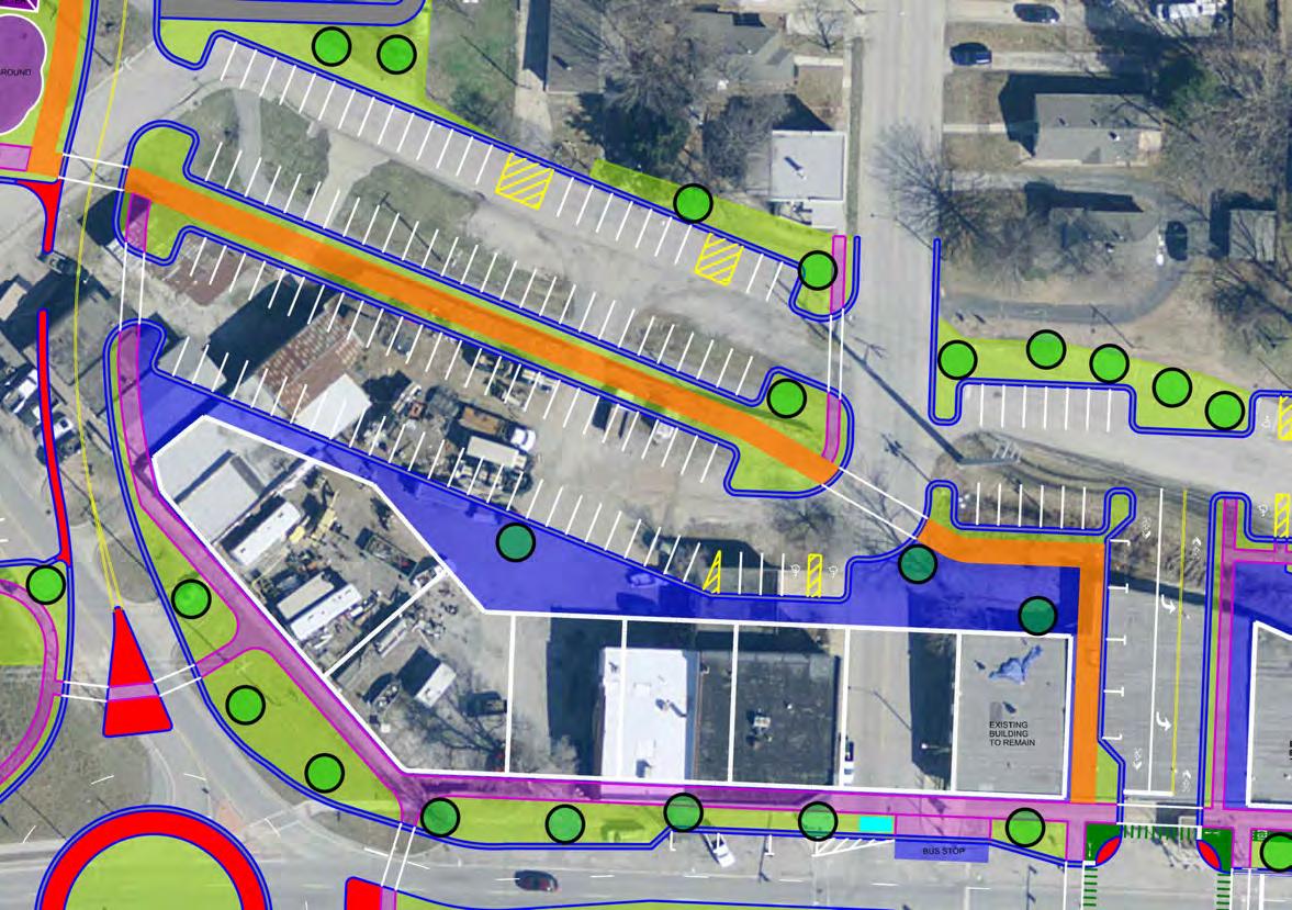
Additional parking and service areas behind buildings will provide an aesthetically-pleasing environment to integrate neighborhoods and The Fairmount District. This will be complemented by on-street parallel parking on both sides of US-24 for the length of the District. This new parking will help create a new feel to the area, protect pedestrians, and act as a traffic calming measure.
The Fairmount District will not only provide convenient locations for goods and services, but its public spaces will create a forum for dialogue, recreation, and foster a distinct sense of place. New civic areas including small plazas and park open space along with the trail connections will celebrate the cultural history not told in other places within the City.
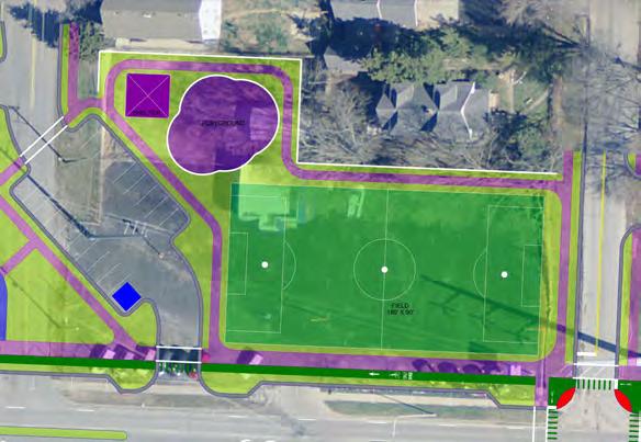
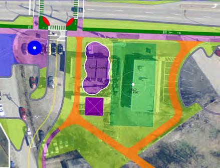
Three possible park / community gathering areas were identified for the City to consider acquiring to meet the communities desire for a centrally located park space, replacing the area lost with Hink Park’s sale to the National Guard in 2017. Each of the locations differs in the number of property owners present, existing right of way available, and size of lot, however, the conceptual design represents similar program components. The three park designs each represent a shade structure, playground, parking, and lawn area for team practice or other outdoor recreation desires.
This option is the largest land area of the three options and can facilitate a 150’ x 300’ full soccer field. This concept closes E Wilson Road over the railroad track. The cleaning up of this light industrial area is important to the revitalization and new development in the Fairmount District.
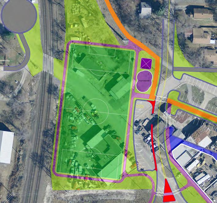
This option requires the purchase of only one property, transition the current used car lot to a neighborhood park area. The field size is about 3/4 size at 90’ x 180’. This site is also well positioned for redevelopment as shown in the 2006 Corridor Master Plan.
This option locates a park on the south side of US-24 at a new realigned intersection of S Lake Drive on the south and S. Hardy Ave on the north. This realignment is key to improving circulation of all modes. The lawn area is multi-use play area of about 60’ x 115’. This option is great for connecting the promenade bike facilities to a new trail system headed to the southeast along the abandoned railroad line, headed towards Truman Road.
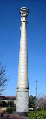
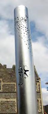
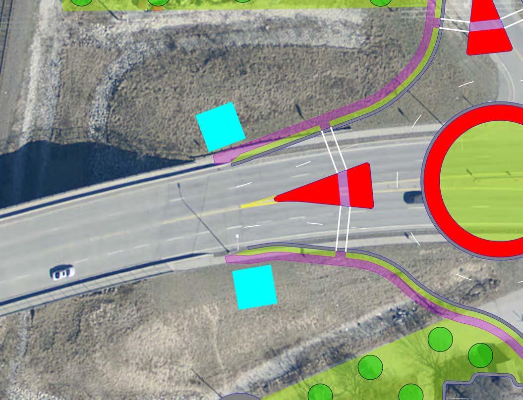
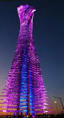
The western gateway to The Fairmount District is a key entry point. The design incorporates a roundabout within US-24 that slows traffic down to the desired speed of 25MPH prior to entering the business area. Preceding the roundabout on the west side (as indicated with black squares) will be a grouping of pillars that are signed “Fairmount” enhancing the entry experience to this distinctive place. The monument pillars should be memorable, attractive and welcoming features, which promote the feeling of arrival. The conceptual plan hints the cultural nature of the area with a lighted glow during nighttime hours.
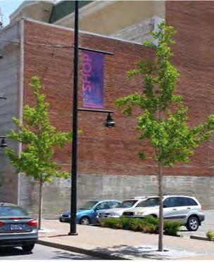
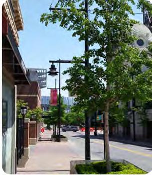
Street trees are very important to the success of the promenade. They provide shade during the summer months, reduce stormwater runoff, and most importantly encourage people to linger, increasing opportunities to patronize retail providing an economic return on investment.
• Don’t plant in front of building entrances
• Minimum of 25’ from a stop light or curb line of an intersection
• Minimum of 5’ from any driveway or utility line
• Minimum of 10’ from fire hydrants and traffic signs
• Spacing should be even and reflect the canopy size at maturity.
• Canopy trees should be used along roadways with a mature clear truck 12’ minimum
• Trees selected should be free of disease
• Trees planted adjacent to each other should match caliper and height to maintain continuity along the street
• Understory/ornamental trees should be used where space is limited, or to achieve diversity in planting design
Street furnishings are much like furnishings in a home; they make the street more comfortable and inviting for visitors. The streetscape must create a comfortable and inviting environment for people to walk, linger, socialize and gather in order for this new promenade concept to work.
Furnishings include benches, trash receptacles, bike racks, interpretive and directional signage/kiosks and other elements. Their placement should be encouraged where pedestrians gather.
The following guidelines are intended to direct future streetscape work to create an attractive setting for visitors and adjacent businesses. These guidelines are meant to establish a minimum standard for the design and appearance of the corridor that meets the project goals, reflects the overall values of the community, accommodates branding efforts on the corridor, and sets the backdrop for the rejuvenated Fairmount District.
• At street lights
• Clustered near crosswalks
• In bumpouts or small plaza space off the main pedestrian way
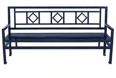
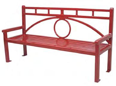
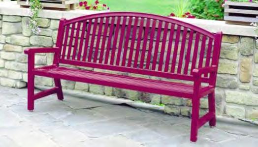
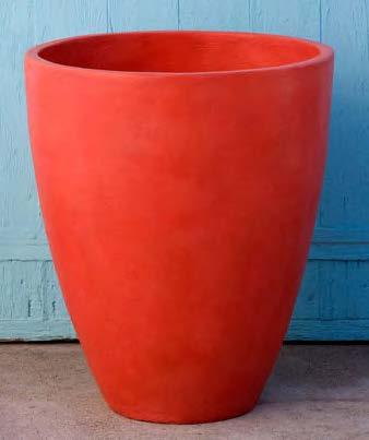
• Style: Site furniture should be colorful supporting the cultural and historical neighborhood theme of The Fairmount District.
• Made by: USA Made product by a furniture manufacturer with more than 15 years of experience, quality product warranties, and can produce benches/painting on an assembly line.
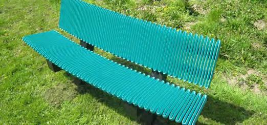
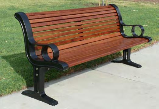
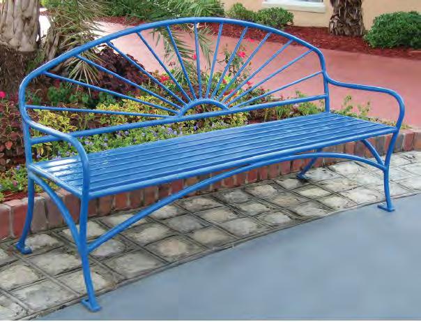
Benches are one of the most important street furnishings. They are highly prized features in front of businesses, particularly those which sell food and beverages. While the intent would be to install wherever needed and desired, too many in one location can dominate the streetscape and cause pedestrian flow restrictions.
• Coordinate with transit stops and crosswalks
• Orient benches toward areas of activity
• Backed: In general, provide backed benches to encourage comfort and socialization
• Style: Powdercoated metal in colors that support the cultural and historical neighborhood theme.
• Mounting: Surface mounted (not embedded) to allow benches to be removed for repaired if needed

Receptacles should be placed in high pedestrian concentration areas, where food and beverages are sold by businesses and in other areas as noted below. They should be located where they can be easily accessed by maintenance crews for emptying.
• Within 5’ of a bench and other vertical amenities (trees, light poles, etc)
• Coordinate with transit stops and crosswalks
• Accessible from roadway for ease of maintenance
• Combined trash and recycling receptacles
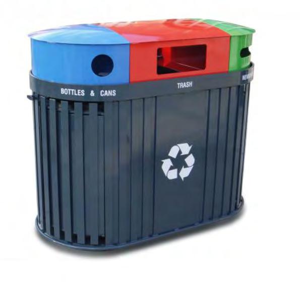
• Size: 30-50 gallons each
• Signage: Use “Landfill” as note for trash receptacles
• Cover: Rain Cover that is over entire receptacle and is rounded to resist trash set on top
• Opening: Side opening for easy trash/recycling removal
• Color: Powdercoated metal in colors that support the cultural and historical neighborhood theme.
• Mounting: Surface mount (not freestanding)
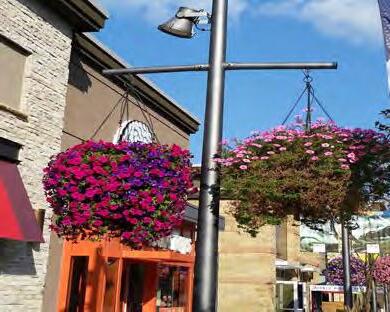
Planters are encouraged throughout the corridor to provide additional opportunities for annual plantings, emphasize entries and allow for flexibility of use areas.
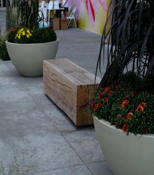
• Feet for self-leveling
• Surface mounted or free standing
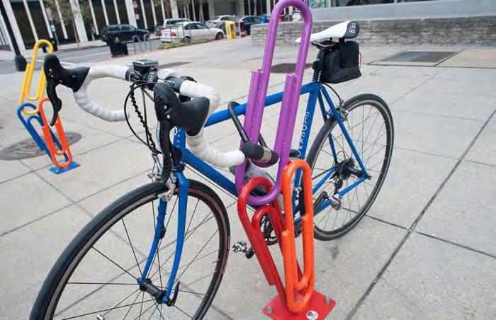
Bicycle racks will be incorporated throughout the corridor especially near plazas and gathering areas. Bicycle racks should be creative to accommodate the district themes.
• Surface mounted
• Metal that is long-lasting and low maintenance
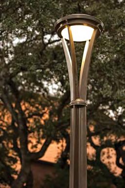
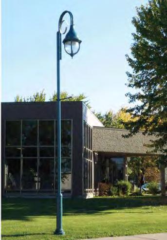
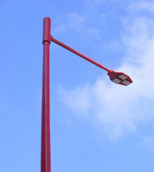
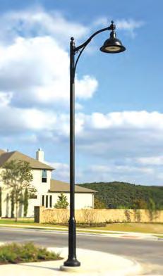
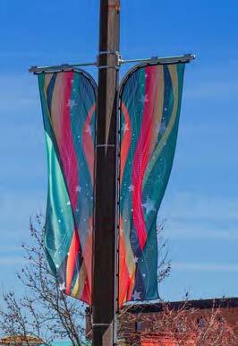
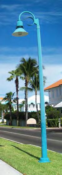
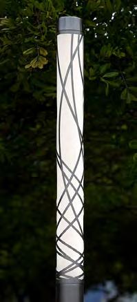
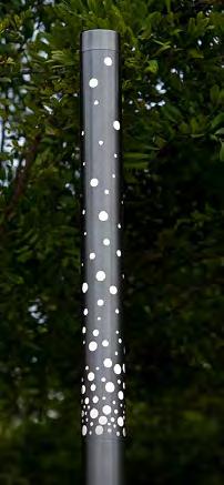
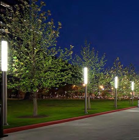
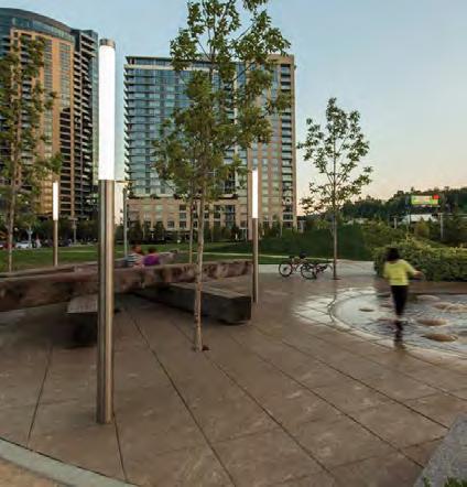
Street lights should be constructed of durable materials with low maintenance requirements. There are a few options being considered for the street/pedestrian light poles and fixtures, but in general, the two fixtures should be mounted to the same pole. The pole/light should make an architectural statement bringing attention to itself. Flags, banners and/or planters should be added to the poles to increase the visual aesthetic of the area.
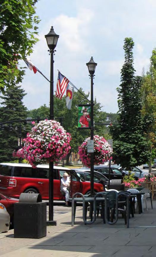
• Meet MoDOT and the City of Independence standards
• Street fixture height: 20-30’ Tall
• Street light spacing: about 100’ OC
• Pedestrian fixture height: 10-14’ Tall
• Pedestrian fixture spacing: about 50’ OC
• Light Source: LED required (Metal halide and high pressure sodium are not acceptable)
• The street light fixture should be available in Type I, II, II& IV optical patterns. Pedestrian light fixtures should be available in Type II optical pattern
POLE MATERIAL / COLOR
• Cast aluminum with red or blue textured powdercoat color.
• Must be capable of supporting planter baskets (2@50 lbs/each)
• Must be capable of supporting flag or banner arm able to withstand EPA: 90 MPH/110 Gusts + 15%
• GFIs - 20a, 120V power outlet at a minimum of 12’ mounting height for seasonal lights
• Light packages for the pedestrian fixtures should consider color changing, specifically the fixtures mounted to the combined street poles
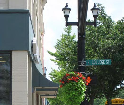
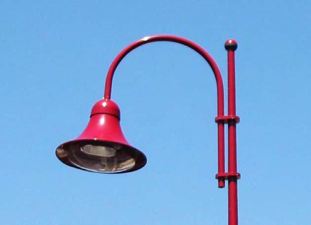
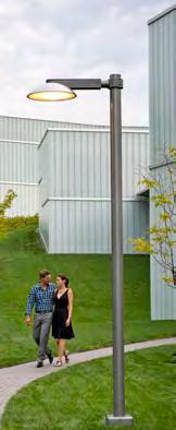
Examples of Cultural and Historical Themed Street and Pedestrian Lights / Accessories

Light columns and themed pendent lights can be used within park areas and plaza spaces to accent areas of interest.
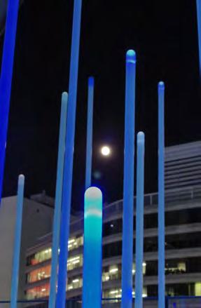
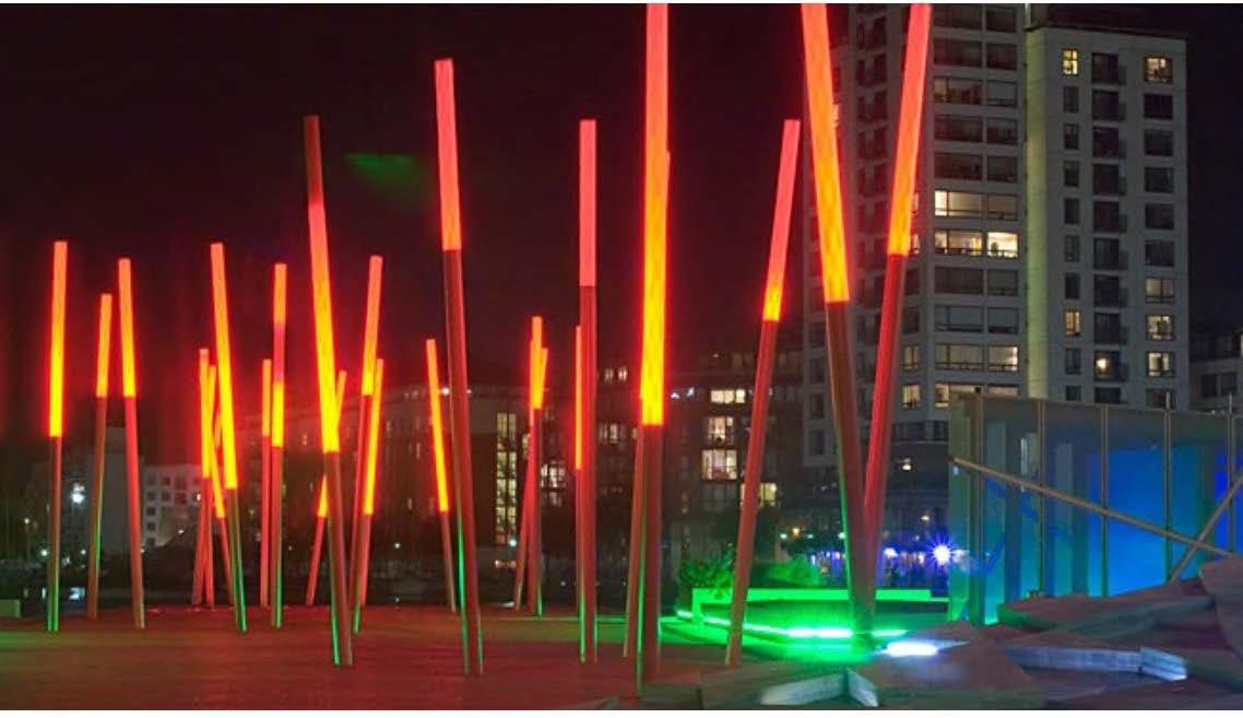
• Height: varies from 5-15’ tall
• Style: Colorful supporting the cultural and historical neighborhood theme.
• Light Source: LED required
• Light packages should consider color changing with white light options
Examples of Plaza / Park Lighting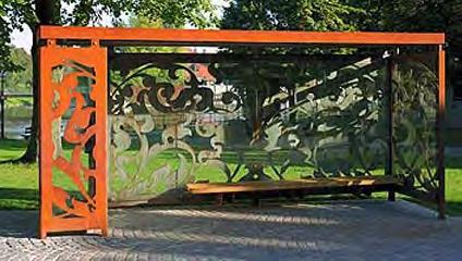
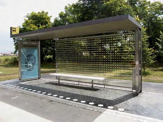
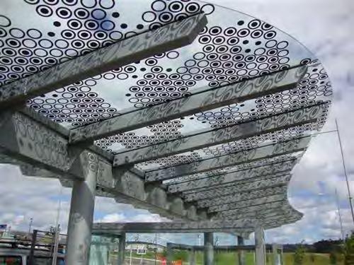
The design of a transit stop within The Fairmount District could reflect the cultural and historical theme of the area.
• Cladding on the shelter should be visible at eye level (about 30 - 72 inches) throughout the structure. In addition, a minimum of 50% of each side should provide visibility in and out of the shelter
• Provide benches within the shelter
• Provide three sided to protect from the wind
• Heaters
• LED Lighting
• Outlet for holiday displays
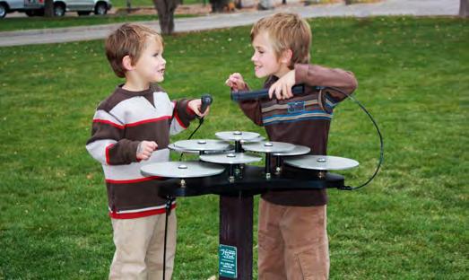
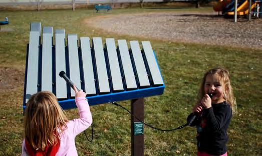
Interactive musical instruments along US-24 is a way to help provide a unique and engaging experience in The Fairmount District. Located at the transit stop, instruments could provide an opportunity for an interactive experience while waiting for the bus. It also provides music to the corridor often found in a commercial area. They could also be integrated into the new neighborhood park location.
• Made with durable materials to last
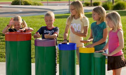
• Require minimal maintenance
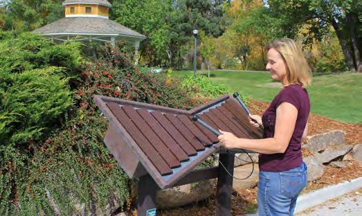 Example of product line by Freenotes Harmony Park
Promenade pavement materials will be mostly concrete to minimize vibrations on wheel chairs. This also allows sections of walkway to be removed and replaced easily with minimal expected variations of color and surface texture. Pavers will be introduced as outside banding allowing for the incorporation of color.
• Concrete surface will use deactivator to give it the look of sandblasted, exposing some of the aggregate color
• All pavers will be set on a concrete subbase to minimize movement and maximize long-term stability
A colorful thematic crosswalk will be used to orient the pedestrian and vehicle to the proper locations for safe crossing.

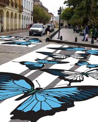
• Use either stamped asphalt system (such as a DuraTherm thermoplastic) OR thermoplastic paint product.
• Receive MoDOT and/or City of Independence approval
• 10’ wide to meet MoDOT standards
The Fairmount District has great momentum – sustaining that momentum will be the continued support from the community, stakeholder committee and local leadership. The decisions from this chapter are based on these groups participating in an open dialogue and guiding the next steps for the future of this corridor.
The chapter provides the necessary tools and next steps to implementing the rejuvenation of The Fairmount District. The Chapter includes:
• Cost Opinion: The cost opinion is based on 2017 costs for all improvements. The costs will need to be adjusted accordingly over time.
• Funding Opportunities: Identifies applicable funding programs to pursue.
• Implementation Priorities and Next Steps: Provides priorities based on public and steering committee input.
The costs outlined are an opinion of probable construction costs based on current information. Costs are influenced by market conditions, changes in scope and inflation. The provided cost opinion will need to adjust accordingly over time.
Understanding that the City has limited sources from which to generate capital for implementation, additional strategies should be utilized to pursue assistance and/or funding. Efforts should also be made to prioritize which public improvements are desired to be implemented initially, and to advocate for their consideration and inclusion in the City’s Capital Improvements Plan (CIP), which prioritizes the construction of future public infrastructure improvements. Leveraging available capital funds as part of a larger overall project effort will likely improve the opportunities for securing additional public funds and provide for quicker realization of the vision for The Fairmount District. The information below describes several sources of funding that may be potentially available for the project.
Most of the federal funding sources are administered through the Missouri Department of Transportation (MoDOT) and the Mid-America Regional Council (MARC). Most, but not all, of these funding programs are oriented toward transportation versus recreation, with an emphasis on alternative transportation systems reducing auto trips and promoting inter-modal connections. Many of the following have yearly or every other year submissions. The next round of submissions for many of these programs start in December 2017. This section is not meant to be an exhaustive analysis of each program and its applicability to the Project but merely introduce them in order to keep them top of mind as opportunities present themselves to advance project funding.
The STP provides states with flexible funds which may be used for a wide variety of projects on any Federal-aid Highways including the NHS, bridges on any public road, and transit facilities. Bicycle and pedestrian improvements are eligible activities under the STP. This covers a wide variety of projects such as non-road facilities, off-road trails, sidewalks, crosswalks, bicycle and pedestrian signals, parking, and other ancillary facilities. The modification of sidewalks to comply with the requirements of the Americans with Disabilities Act is also an eligible activity.
This program funds projects that serve a transportation need and can be used to build a variety of pedestrian, bicycle, streetscape and other improvements that enhance the cultural, aesthetic, or environmental value of transportation systems.
Funds are used to pay for transportation projects, including bicycle and pedestrian improvements that improve air quality.
Grants are used to identify and reduce barriers and hazards to children walking or biking to school. This program includes funding for construction. Investigate opportunities to better connect to the Fairmount Elementary School.
This program funds improvements to rural and urban roads that are part of the NHS, including the interstate system. Bicycle and pedestrian facilities within NHS corridors are eligible activities for NHS funds.
Funds projects designed to achieve significant reduction in traffic fatalities and serious injuries on all public roads and pedestrian/bike pathways.
The FTA funds could be used for various elements of The Fairmount District plan. In addition to traditional transit projects, including intermodal facilities such as bicycle parking at park and ride and transit stations, these funds can be used to secure right-of-way for transit/rail corridors.
The project could be submitted for FLAP funding that would allow the project area to be extended to the east and connected to the Truman Library. This would grow the project by an additional 6,900 feet but provide as much as an 80% match for streetscape/bicycle facility improvements for the entire project area.
The Cost Share Program provides financial assistance to public and private applicants for state highway and bridge projects satisfying a transportation need. As applied to the Fairmont Project, the MoDOT Cost Share Program allows for 50% participation from the State up to $10 Million. In Recent history this program was suspended but gained partial funding of $10 Million in 2017, $15 Million in 2018 and a $20 Million in 2019.
A road transfer can provide significant funding for an infrastructure project but it also carries with it significant long term cost. The project team’s prior experience suggests that MoDOT could provide upwards of $1 Million per mile for a project of this size. Before something like this could be considered as a viable strategy a detailed cost benefit analysis would need to be completed to substantiate it. If the City did agree to take transfer of the road from MoDOT, however, it can have a positive impact on the amount of Cost Share the project qualifies for.
Given that most of the Federal and State funding opportunities above are a match program the City would need to secure a local match to access them. Generally this is achieved by pledging one or more local revenue streams to some type of debt, inkind or, in the right circumstances, a pay as you go strategy.
Tax Increment Financing (TIF), Transportation Development Districts (TDD) and Community Improvement Districts (CID) capture tax increment or create additional taxes for the benefit of the project area. These funds are eligible for corridor infrastructure improvements.
Tax Increment Financing allows for the capture of 100% of incremental local property tax and 50% of incremental local sales tax for 23 years to be spent on the redevelopment of a Blighted Area as defined by Statute.
The focus of the funding opportunities for the Fairmont Project centers on the redevelopment of specific locations. The City of Independence could consider the use of TIF to accelerate that redevelopment and share a portion of the captured revenues with the specific location and use a portion to advance the Project.
TIF begins with the establishment of a TIF Commission by the City consisting of specific members to represent the impacting taxing jurisdiction. A plan with specific statutory requirements is submitted for recommendation by the TIF Commission to the governing body of the City. Next the City takes up the TIF Plan and approves it by Ordinance. A TIF plan is usually implemented by a Redevelopment Agreement.
Advantages:
• All allowable spending matches up
• Local control
• Spurs redevelopment
• A plan can cover a large Redevelopment Area
Challenges:
• Impacts other taxing districts
• Political exposure to City
A Transportation Development District (TDD) may be created to act as the entity responsible for developing, improving, maintaining, or operating one or more “projects” relative to the transportation needs of the area in which the District is located. A TDD may be created by a request petition filed in the circuit court of any county partially or totally within the proposed district.
The district has the authority to finance the project through special assessments; property tax, sales tax, or toll roads. In addition, they can liquidate any and all of the above methods through debt financing.
Advantages:
• Most allowable spending matches up
• Multiple ways to form (property owners, voters or City)
• Multiple ways to approve sales tax (registered voters or property owners)
• Can be noncontiguous
Challenges:
• Use of fund restricted to transportation only
• Formed by Court
• Tax requires an election
• Political exposure to City
• Tax increase
A Community Improvement District (CID) may be either a political subdivision or a not-for-profit corporation. CID’s are organized for the purpose of financing a wide range of public-use facilities and establishing and managing policies and public services relative to the needs of the district.
A CID is a separate legal entity, and is distinct and apart from the municipality that creates the district. A CID is, however, created by ordinance of the governing body of the municipality in which the CID is located and may have other direct organizational or operational ties to the local government, depending upon the charter of the CID.
A CID may finance new facilities or improvements to existing facilities that are for the use of the public. A CID may also provide for maintenance and upkeep of facilities
Advantages:
• Broader use of funds than TDD
• Ease of creation, formed by City
• Locally driven
• Board could be appointed by City
Challenges:
• Tax increase
• Political exposure to City
• Limited to public improvements unless blighted
The Challenge for all 3 of these funding opportunities (CID, TDD and TIF) is creating enough revenue generation to be cost effective and make an impact on the project. For instance for a CID or TDD the most logical funding mechanism is a Sales tax. An initial look at a benefit district directly related to the Fairmont Project would generate about $25,000 a year at a maximum 1% sales tax. This would barely be enough to support the Districts administrative expenses. If the City expanded the scope of the project corridor wide this revenue stream could grow to $885,000 a year.
Capital Improvement Project: This project could be added to the next capital improvements program for implementation in about 5 years. This would be considered a pay as you go strategy.
The Fairmount District corridor and specifically US-24 is part of a larger transit system across city and county lines. One of the primary benefits of this overall design and planning approach for revitalizing The Fairmount District is that it provides flexibility for future transportation connectivity. The KCATA is working on a study for a future MAX line bus route into Independence. This corridor is ideally located for enhanced bus services with large redevelopment potential along the corridor. This plan has been crafted to balance the needs of vehicular traffic today, as well as the anticipated needs of expanded transit service in the future.
Non-profit partners: Kansas City River Trails, Inc. is an excellent example of how civic volunteer groups can promote and develop trails in a city. This non-profit entity has worked collaboratively with various City departments for funding and implementation assistance and has used its private status to acquire matching corporate funds and grants that the City may not have been able to obtain.
Local foundations aligned with sustainability, greenways, exercise, trails or bicycling may provide a source of private funds.
Individuals, businesses, or corporations may be interested in sponsoring elements of the project. Naming rights, plaques or other forms of recognition are typically placed on constructed pieces in the corridor. Sponsorship is also a good way to fund corridor elements such as benches, trash receptacles, and interpretive areas.
Any one of the revenue streams above, once committed, could be pledged to some type of debt instrument to accelerate the project funding. This could take the form of special district revenues, city revenues, or even match dollars from a non-local source that are programed at some point in the future.
The City could pursue a project specific bond issue or they could add this project to its upcoming vote for approval from its citizens to implement this streetscape as one of the City priority projects, expected to occur in 2018. This would require a city wide election and entail putting city credit on the line.
The MTFC provides direct loans at a subsidized interest rate to Transpiration Projects within the State of Missouri. Any one or multiple of the revenue streams above can be pledged to MTFC to support a sizable project fund.
The following design components to the plan have been identified as priorities within The Fairmount District. In most case, futher investigation, design and planning are required.
Work with the City of Sugar Creek and MoDOT to resolve the flooding issue at US-24 and Sugar Creek with the culvert failure. This is the highest priority for the corridor.
The City of Independence to investigate all three options identified in the master plan for the implementation of a park/neighborhood gathering area near the center of The Fairmount District. This might be the second highest priority for the steering committee.
Implementation of a community park visible from US-24 is a high priority of this plan.
The Farimount District could work with the City to establish a Community Improvement District (CID) with an initial defined area around the Fairmount District and expandable to a much larger area along US-24.With the addition of an approved sales tax, additional revenue would be dedicated to services, improvements and additional maintenance throughout the corridor.
S Huttig Ave should be removed for one block to the north of US-24. This will allow for the reconstruction of a single traffic signaled intersection with protected bicycle facilities connecting bicycle movement from the north to south of US-24. Acquisition of the property north of S Ash should be considered or working with a developer to redevelop this important intersection.
Implementation of road re-alignment, reduced lane widths, landscaped median, on-street parallel parking and wide pedestrian zones. Improvements could include vertical elements such as street trees and lighting to add more color and cultural aesthetic to the corridor.
Aquisition of old right-of-way along the abandoned railroad would allow the The Farimount District to be connected to Truman road to the southeast near Sterling with an unusual to Independence of street trail environment. In discussions with the Mayor and City Administrator of the City of Sugar Creek, they would be interested in a joint or multi-jusidictional application. In addition, both the city’s of Independence and Sugar Creek should discuss regional connectivity opportunities with US-24 as a major spine and with new north/south connections to the existing parks, historic areas, and regional trails.
Based on conversations with MoDOT, the City should consider expanding the bicycle and pedestrian facilities to the east utilizing the Federal Lands Access Program cost share program. As a secondary source of leveraged dollars to a CID formation, the City should investigate application for connectivity to the Truman Library about 6,700 feet to the east of S Sterling Avenue. In discussions with the Mayor and City Administrator of the City of Sugar Creek, they would be interested in a joint or multi-jusidictional application.
A pedestrian bridge over S. Sterling Ave at E. 9th Street will connect the neighborhoods around Fairmount to Bundshu Park.
There is a high interest to investigate the ownership, dredging and restoration of the lake into a community asset with new recreation opportunities.
The following areas require additional exploration as part of the next step in the development of this corridor project. The items below are considered next steps to this plan. The exact order of next steps will be defined by avaible funds, City priorities, and developer/partnership interest.
Based on the review of funding strategies listed above and current conversations with City leadership, a Plan of Finance should be solidified that documents a game plan for moving the project into implementation. While a finite solution may not exist the City should closely monitor all programs and be ready to execute when external funding leverage is at its peak. This means not only getting project design ready but understanding what local match exists and be ready to apply it.
Complete a traffic study to confirm traffic counts both on US-24 and side streets, access management of left turn movement with center median adjustments, and road closure/realignments.
The creation of design standards, land use codes and signage requirements would improve the Corridor’s visual quality. This process will solidify the thematic elements for the corridor as a guideline for all future development along the corridor. This process could include the design of gateway features as an important branding element for the new rejuvenated The Fairmount District.
The City will complete a topographic and boundary survey for the corridor. With this information, the roadway, promenade and bicycle improvements can be designed and bidable documents prepared.
The 1 block segment from E Wilson Road to S Huttig Ave has the tightest distance between the existing building facades along the north and south sides of US-24 at about 107 feet. The buildings on the north side are in poor condition. Should the two buildings need to be demolished, the new building facades should match the buildings east of S Huttig Ave (at about 118 feet from building façade to building façade).
The ROW through the corridor is about 80 feet wide. With the redevelopment of the The Fairmount District, either 1) additional ROW should be acquired to 110 feet, or 2) Joint Use Easements Agreements (JUEA) signed with the property owners allowing the City to build the pedestrian infrastructure.
An environmental study should be completed to determine if there is high levels of pollution within Crisp Lake. There is concern that runoff from a fire at a now defunct maufacturing plant upstream of the lake caused toxic chemicals to be washed into the lake where they remain today.
As the master plan describes, the best way to slow traffic through the corridor is to implement a roundabout. At a meeting with MoDOT on August 7, 2017, MoDOT recommended a roundabout as the best traffic calming tool to applicable for The Fairmount District. Designed properly, will best encourage trucks an vehcle to move through the district at 25 MPH.
Complete additional studies and funding strategies to connect The Fairmount District to the Truman Library to the east and Hill Park to the South.