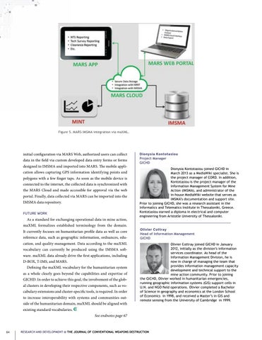
Figure 5. MARS-IMSMA integration via maXML.
initial configuration via MARS Web, authorized users can collect data in the field via custom developed data entry forms or forms designed in IMSMA and imported into MARS. The mobile application allows capturing GPS information identifying points and polygons with a few finger taps. As soon as the mobile device is connected to the internet, the collected data is synchronized with the MARS Cloud and made accessible for approval via the web portal. Finally, data collected via MARS can be imported into the IMSMA data repository. FUTURE WORK
As a standard for exchanging operational data in mine action, maXML formalizes established terminology from the domain. It currently focuses on humanitarian profile data as well as core reference data, such as geographic information, ordnances, education, and quality management. Data according to the maXML vocabulary can currently be produced using the IMSMA software. maXML data already drive the first applications, including D-BOX, T-IMS, and MARS. Defining the maXML vocabulary for the humanitarian system as a whole clearly goes beyond the capabilities and expertise of GICHD. In order to achieve this goal, the involvement of the global clusters in developing their respective components, such as vocabulary extensions and cluster-specific tools, is required. In order to increase interoperability with systems and communities outside of the humanitarian domain, maXML should be aligned with
Dionysia Kontotasiou Project Manager GICHD Dionysia Kontotasiou joined GICHD in March 2013 as a MediaWiki specialist. She is the project manager of CORD. In addition, Kontotasiou is the project manager of the Information Management System for Mine Action (IMSMA), and administrator of the in-house MediaWiki website that serves as IMSMA’s documentation and support site. Prior to joining GICHD, she was a research assistant in the Informatics and Telematics Institute in Thessaloniki, Greece. Kontotasiou earned a diploma in electrical and computer engineering from Aristotle University of Thessaloniki.
Olivier Cottray Head of Information Management GICHD Olivier Cottray joined GICHD in January 2012, initially as the division’s information services coordinator. As head of the Information Management Division, he is now in charge of managing the team that provides information management capacity development and technical support to the mine action community. Prior to joining the GICHD, Olivier worked in humanitarian emergencies, running geographic information systems (GIS) support cells in U.N. and NGO field operations. Olivier completed a Bachelor of Science in geography and economics at the London School of Economics in 1998, and received a Master’s in GIS and remote sensing from the University of Cambridge in 1999.
existing standard vocabularies. See endnotes page 67
64
RESEARCH AND DEVELOPMENT @ THE JOURNAL OF CONVENTIONAL WEAPONS DESTRUCTION


