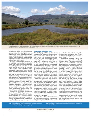
The heavily litigated Blue River boasts less water than it might otherwise have carried to its confluence with the Colorado, pictured here, due to upstream diversions to the East Slope via Denver Water’s Dillon Reservoir and the Roberts Tunnel.
River Storage Project Act. The Act’s primary purpose was to store and regulate flows on the Colorado River, allowing Upper Basin states to fully develop their entitlements and put that water to beneficial use while meeting 1922 Colorado River Compact and 1944 Mexico Treaty requirements. By 1950, Colorado’s population was up to 1,325,000. The West Slope and the Colorado River District badly wanted Colorado River Storage Project units to store West Slope water, while Front Range water providers saw the Act as competition for the waters they might need for future development. Plans for specific storage projects were met with severe opposition. In the end, the Act authorized construction of the Flaming Gorge, Aspinall Unit, Navajo, and Glen Canyon dams in the Upper Basin. With development of Navajo in New Mexico came the San-Juan Chama Project, a transbasin diversion drawing water from Colorado’s San Juan River south and out of state into New Mexico’s Rio Grande Basin. In Colorado, the Aspinall Unit is comprised of Blue Mesa, Morrow Point and Crystal dams and reservoirs, located on the Gunnison River above the Black Canyon. Although the Aspinall Unit is not a transbasin diversion, West Slope water stored in Aspinall Unit reservoirs helps maintain diversions out of the Colorado River Basin and meet water needs across the state by pooling and releasing water to meet Colorado River Compact requirements.
Denver Water and the Blue River While the Fryingpan-Arkansas Project and Colorado River legislation were developing, so was Denver Water’s Blue River claim. Denver had claimed a right on the Blue in 1923, and the time was coming to develop that water. In 1942, Denver Water filed a request for adjudication of its Blue River rights with a 1914 priority date, the year the utility did a casual reconnaissance of the river. A 1914 decree would give Denver’s Blue River water priority over the 1922 Colorado Basin Compact and over all projects that came after, including the Colorado-Big Thompson Project. A 1914 decree for Denver’s upstream project would likely cut into the Green Mountain Reservoir replacement and mitigation water that was key to the Colorado-Big Thompson and would diminish a pool of water set aside for power generation and western Colorado’s future use. Very quickly, the West Slope and Bureau of Reclamation opposed Denver’s filing. After years in court and various water rights claims, Reclamation in 1949 filed a separate claim to affirm its right to water on the Blue over Denver’s claims. Reclamation estimated that its power production at Green Mountain and the associated revenue would be sliced in half if Denver received a 1914 decree. In 1952, the court found Denver’s claims on the Blue legitimate but assigned the utility a priority date of 1946. Denver would
1962 Fryingpan-Arkansas Project is signed into law after Ruedi Reservoir is identified as West Slope compensatory storage
20
receive its Blue River water, but only after all senior rights filed before 1946, including all Colorado-Big Thompson water, received theirs. Denver needed this water. The city was again pushing up against demand. During the 1940s, Denver’s population grew nearly 30 percent, from 322,000 to 416,000 residents. Growth in the suburbs was even more phenomenal. The population in Adams County increased nearly 79 percent; Arapahoe County, 62 percent; Boulder County, 29 percent; and Jefferson County, 83 percent. This was the biggest population boom since the 1880s gold rush. In the postwar years, Denver was issuing 5,000 new taps per year. By 1950, total water usage exceeded 100,000 acre-feet. Denver even drew a “blue line” defining service area boundaries in 1951, enclosing 114 square miles to ensure the utility could continue to meet growing demand. Metro area growth continued to explode in the 1950s. Denver lifted the blue line in 1960 because of developing feuds with sprawling suburbs that were demanding water. By erasing the blue line, Denver Water was accepting continued population and geographic expansion and would need to seek more water for the Metro area—an obvious threat to the West Slope. Denver could provide water for a limited service area, but for its expanding suburbs, the utility needed more.
1962 Denver Water’s Roberts Tunnel is completed to transport Blue River water to the South Platte
WATER EDUCATION COLORADO