COLORADO-BIG THOMPSON & WINDY GAP
Horsetooth Reservoir
Arapaho National Forest
Shadow Mountain Reservoir
GRAND LAKE
Alva B. Adams Tunnel
Grand Lake
S
LONGMONT St. V rain Cr e e k
ut
ek er Cre uld Bo
FRASER
NEDERLAND
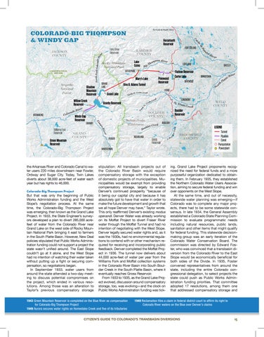
Colorado-Big Thompson Project
But that was only the beginning of Public Works Administration funding and the West Slope’s negotiation process. At the same time, the Colorado-Big Thompson Project was emerging, then known as the Grand Lake Project. In 1933, the State Engineer’s surveyors developed a plan to divert 285,000 acrefeet of water from the Colorado River near Grand Lake on the west side of Rocky Mountain National Park bringing it east to farmers in the South Platte Basin. However, New Deal policies stipulated that Public Works Administration funding could not support a project the state wasn’t unified around. The East Slope couldn’t go at it alone, and the West Slope had no intention of watching their water taken without putting up a fight or securing compensation, so negotiations began. In September 1933, water users from around the state attended a two-day meeting to discuss potential compromises on the project, which ended in various resolutions. Among those was an alteration to Taylor’s previous compensatory storage
Gross Reservoir
stipulation: All transbasin projects out of the Colorado River Basin would require compensatory storage with the exception of domestic projects of municipalities. Municipalities would be exempt from providing compensatory storage, largely to enable Denver’s continued prosperity “because of it being our capital city and because it has absolutely got to have that water in order to make the future development and growth that we all hope Denver may have,” Taylor wrote. This only reaffirmed Denver’s existing modus operandi. Denver Water was already working on its Moffat Project to divert Fraser River water through the Moffat Tunnel and had no intention of negotiating with the West Slope. Denver legally secured water rights and, as it was the 1930s, had no environmental regulations to contend with or other mechanism required for receiving and incorporating public feedback. Denver completed the Moffat Project in 1936. The tunnel now delivers about 44,000 acre-feet of water per year from the Williams Fork and Moffat collection systems in the Colorado River Basin into South Boulder Creek in the South Platte Basin, where it eventually reaches Gross Reservoir. From 1933 to 1935, as the Grand Lake Project evolved, discussion around compensatory storage, too, was evolving—and the clock on Public Works Administration funding was tick-
1943 Green Mountain Reservoir is completed on the Blue River as compensation for Colorado-Big Thompson Project 1949 Aurora secures water rights on Homestake Creek and five of its tributaries
WELD COUNTY
BOULDER
ou S. B
LEGEND BROOMFIELD COUNTY
WINTER PARK
the Arkansas River and Colorado Canal to water users 220 miles downstream near Fowler, Ordway and Sugar City. Today, Twin Lakes diverts about 38,000 acre-feet of water each year but has rights to 46,000.
r Rive te t Pla th ou
Boulder Reservoir
BOULDER COUNTY
r Cre ek
So
GRAND COUNTY
Indian Peaks Wilderness
JOHNSTOWN
BERTHOUD
reek nC rai V t.
r
Green Mountain Reservoir
GRANBY
e Riv er as Fr
Windy Gap Reservoir
GREELEY
LYONS
Vrain Creek th St. Nor
Granby Reservoir
Flatiron Reservoir Carter Lake
Pinewood Reservoir
Mary’s Lake
iver do R a r o Col
Williams Fork Reservoir
LOVELAND
lde
KREMMLING
pson River hom T g
ESTES PARK
hS
Willow Creek Reservoir
Bi
re Riv er
d
Lake Estes
Rocky Mountain National Park
CONTINENTAL DIVIDE
FORT COLLINS
LARIMER COUNTY
ou
North Fork Colorado R ive r
Long Draw Reservoir
aP el ch Ca
JACKSON COUNTY
To Cache la Poudre River
Tunnel Pipeline Canal Pumpstation Powerplant
ing. Grand Lake Project proponents recognized the need for federal funds and a more purposeful organization dedicated to obtaining them. In February 1935, they established the Northern Colorado Water Users Association, aiming to secure federal funding and win over opponents on the West Slope. At the same time, and out of necessity, statewide water planning was emerging—if Colorado was to complete any major projects, there had to be some statewide consensus. In late 1934, the General Assembly established a Colorado State Planning Commission to evaluate programmatic needs including natural resources, public lands, sanitation and other items that might qualify for federal funding. This statewide decisionmaking group was an early iteration of the Colorado Water Conservation Board. The commission was directed by Edward Foster, who was convinced that a transbasin diversion from the Colorado River to the East Slope would be economically beneficial for both sides of the Divide. In 1935, Foster convened representatives from around the state, including the entire Colorado congressional delegation, to select projects the state could push as Public Works Administration funding priorities. That committee adopted 17 resolutions, among them one that addressed compensatory storage and
1949 Reclamation files a claim in federal district court to affirm its right to Colorado River waters on the Blue over Denver’s claims
CITIZEN’S GUIDE TO COLORADO’S TRANSBASIN DIVERSIONS
15