Colorado’s Transbasin Diversions
Source: Statewide Water Supply Initiative 2010 (population figures from 2010 U.S. Census, irrigated acreage from 2005)
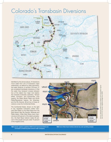
Identified by the arrows above, 44 diversions move water from one of Colorado’s major watersheds, as defined by state administrative water divisions, to another. Of those, 27 are considered transbasin diversions, in that the water they transport crosses between two of the state’s four major river basins: the Colorado (Colorado mainstem, Yampa/ White, Gunnison, and Dolores/San Juan basins), the Platte (North Platte and South Platte/Republican basins), the Arkansas, and the Rio Grande. All but two of these diversions cross the Continental Divide. The Continental Divide, shown on the right in red, separates Colorado’s wetter Colorado River Basin on the West Slope from the East Slope’s drier Rio Grande, Arkansas and Platte basins. While West Slope rivers channel around 80 percent of the state’s precipitation, the East Slope harbors nearly 90 percent of the people and just under 75 percent of the irrigated acres. 1922 Colorado Legislature establishes Moffat Tunnel Improvement District and Commission to retrofit the pioneer tunnel for water conveyance
8
1922 Denver Water Board institutes alternate day water sprinkling schedule
WATER EDUCATION COLORADO