30
yukon-news.com
YUKON NEWS
Friday, November 13, 2015
Face of northern Alaska pitted by tundra fire Champagne Aishihik Trust Board Champagne and Aishihik First Nations (CAFN) is seeking Citizens to sit on the Champagne Aishihik Trust (CA Trust) for a term of three years.
by Ned Rozell
The CA Trust is established by the Trust Deed of Settlement to oversee CAFN’s compensation and investment funds, including the business investments of Dakwakada Capital Investments. The Trust meets a minimum of four times a year (quarterly) and additionally as required.
ALASKA
SCIENCE
DEADLINE TO APPLY: 4:30 p.m., Wednesday, November 18, 2015 For more information and the CAFN Boards and Committees application visit: http://cafn.ca/government/board-committee/ Please submit your application and resumé to: Angie Wabisca (867) 456-6881 Fax (867) 667-6202 awabisca@cafn.ca
RADON GAS not in my house
You can’t see, smell or taste it. But it is the second leading cause of lung cancer, and it can enter Yukon homes anywhere it finds an opening at ground level. The challenge, as with any unwelcome visitor, is getting it to leave!
COMMON RADON ENTRY POINTS 1 Soil 2 Cracks in the floor and walls ls connected with the soil 3 Gaps around pipe fittings and support posts in the foundation 4 Floor drains & sump pits
2
E
ight summers ago, a bolt of lightning struck a dry tundra hillside in northern Alaska. Fanned by a warm wind that curled over the Brooks Range, the Anaktuvuk River fire burned for three months, leaving a scar visible from the International Space Station. The charred area was larger than Cape Cod. While northern Alaska’s treeless terrain has not seen a repeat of the largest tundra fire in modern times, researchers have kept their eyes on the Anaktuvuk River site. They watched green plants return in great number. Zooming out a bit, they watched the smooth face of the landscape become pocked with thaw-pits. The development of what scientists call thermokarst happens often in the northern boreal forest after a fire vaporizes moss and other ground cover. In a new study, Ben Jones of the USGS Alaska Science Center looked at what happens when a big fire happens north of the tree line. He and his coauthors, including pilot and glaciologist Chris Larsen of the Geophysical Institute, compared LIDAR images to see how the roughness of the landscape increased since the fire. LIDAR is a laser system flown on a plane at about 3,000 feet elevation. The aircraft shoots laser light from its belly. A computer calculates the time it takes for the beam to return. With that information, people can draw a super accurate topo map. The scientists were intrigued by
Courtesy Ben Jones/Yukon News
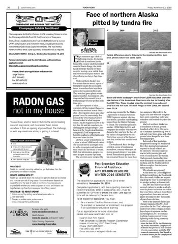
Tundra differences due to thawing in the Anaktuvuk River burn area, photos taken four years apart.
Courtesy Ben Jones/Yukon News
Black-and-white landscapes made from LIDAR data that show the new texture of the Anaktuvuk River burn site due to thawing after the 2007 fire. These images show the contrast to an adjacent area that did not burn. The first image is from 2009, the second from 2014. such a map created for the Alaska Department of Transportation in 2009. Engineers wanted information before a possible road-building project from the Dalton Highway to Umiat. The scientists sponsored another LIDAR flight in 2014 and compared the results. With the two datasets, they saw how the face of the tundra changed after the fire. Thirty-four percent of the burned area they studied had sunk in some fashion. The Anaktuvuk River fire happened in a zone of continuous permafrost, country where you hit frozen ground wherever you sink a shovel. Permafrost is ground that has remained frozen for more than
1 4
Post-Secondary Education Financial Assistance APPLICATION DEADLINE WINTER 2016 SEMESTER
3
WHAT IS IT? Radon is a naturally occurring radioactive gas that comes from the ground and can collect in houses. WHAT’S WRONG WITH IT? Radon gas can break down into radioactive particles that can be inhaled and increase your risk of lung cancer. Your risk of cancer depends on several factors: the level of radon in your home, how long you are exposed and whether you smoke (exposure to radon and tobacco use together can significantly increase your risk of lung cancer). WHAT CAN I DO ABOUT RADON? 1. Inform yourself by visiting www.takeactiononradon.ca 2. Test your home 3. Contact a certified radon professional at www.c-nrpp.ca/find-a-professional
For more info, go to www.takeactiononradon.ca Health Canada www.hc-sc.gc.ca and search “radon” Yukon Housing Corporation www.housing.yk.ca/radon
The deadline for applications for the 2016 winter semester is November 16, 2015. Completed applications, with the supporting documents (recent transcripts, letter of acceptance, etc.), must be submitted to KDFN on or before this date. Late applications will be deferred to the next term. To be eligible for assistance, you must; • •
Be a Kwanlin Dün First Nation citizen; and, Be enrolled, or accepted for enrollment, in a program in an accredited institution of learning.
For an application or for more information please visit www.kwanlindun.com or: Kwanlin Dün First Nation Post-Secondary & Specific Program Coordinator House of Learning (#5 O’Brien Place) Phone: (867) 633-8422 Fax: (867) 633-7841 Email: education.reception@kdfn.net
two summers. Much of it is the legacy of a time when air temperatures were cooler than today and relentless cold soaked deep into the ground. Much of northern Alaska has a foundation of frozen ground hundreds of feet deep. The warm air of summer thaws the top foot of soil each year. Moss, grass and other ground cover keeps the heat from reaching deeper. But much of that insulation disappeared during the Anaktuvuk River fire, leaving frozen ground exposed to the air of short arctic summers. The landscape has reacted with yawning pits and webs of cracks across the tundra. Underground chunks of ice that were thousands of years old are now melting, and the Anaktuvuk River hills are rougher than they were before the fire. Why should anyone care? A road from the Dalton Highway to Umiat would cross the Anaktuvuk River fire swath. Gullies are appearing along the route as underground ice wedges as large as houses melt. The 2007 fire itself released half as much carbon in smoke as all other arctic plants worldwide sucked in that year. More carbon is being freed as permafrost thaws and ancient plants decompose after thousands of years frozen in time. Most of the dramatic landscape changes happened by 2011, four years after the fire. That’s when permafrost rich with ice began to thaw. Jones hopes to sponsor another LIDAR flight in 2017 to continue tracking changes caused by one lightning strike during a very dry northern summer. Since the late 1970s, the University of Alaska Fairbanks’ Geophysical Institute has provided this column free in cooperation with the UAF research community. Ned Rozell is a science writer for the Geophysical Institute.