7 minute read
SITE SELECTION

from Fishing Harbour
by beeeee

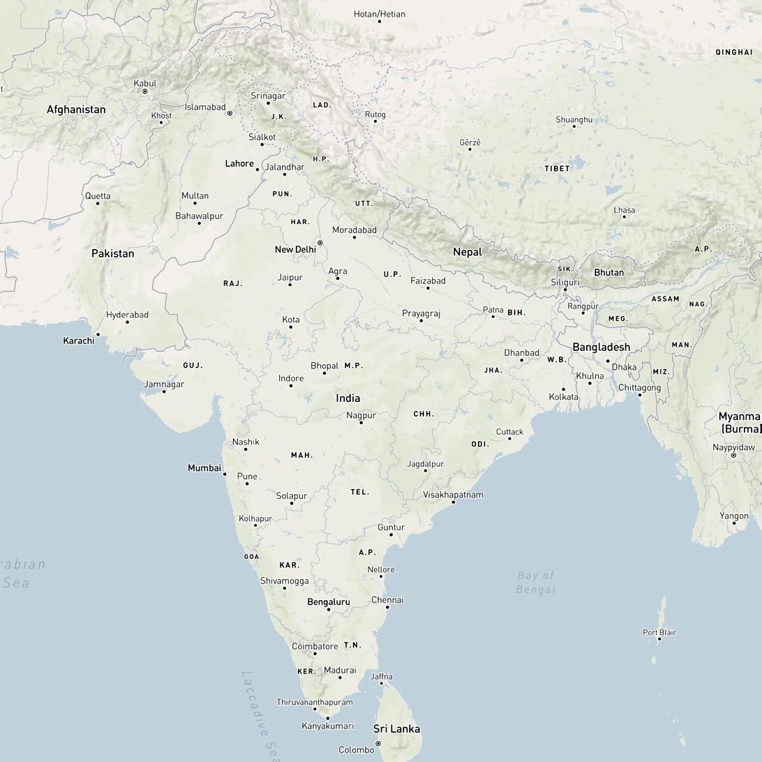
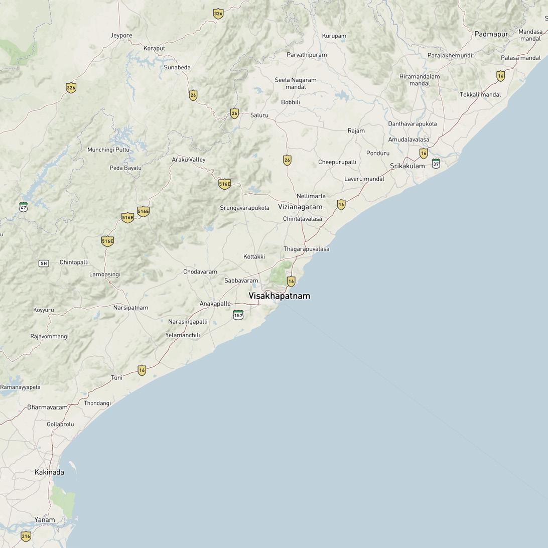
District: Visakhapatnam
Location: Visakhapatnam Port , Port Area.
Advertisement
Co-ordinates: 742655.73 m E, 1957260.27 m N
Site Area: 3.8 acres. With water front area excluding .
• India • Visakhapatnam
• Port Area • Inner Harbour

Accessbility: Airport – 16.8km Railhead – 10.9km Seaport – 3.3 km
Site Area: 3.4 acres
Soil Type: Sandy ground zone
Vegetation: Site consists lot of trees which can or may be used for site landscaping.
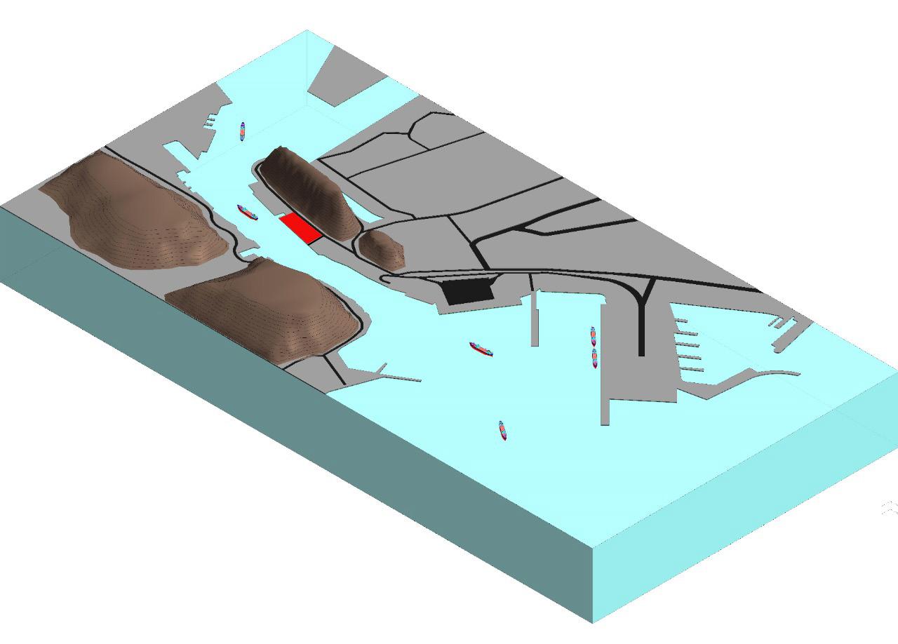
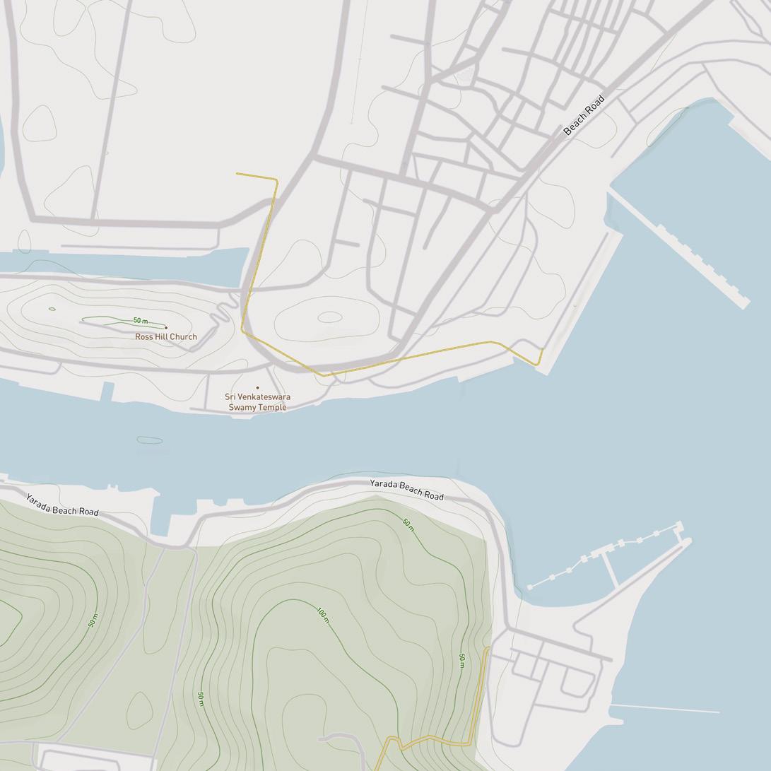
Topography: Site is located in sandy ground zone which also holds Visakhapatnam outer harbor on it, suits for a 2 story hygienic wholesale fish market complex. • Site is located in between inner and outer Visakhapatnam harbors. • The channel connected to site is called as inner channel, connecting outer and inner harbour. • Site is surrounded by 3 huge topographic elements, hills.
LandUse Pattern: Industrial land zone
Norms And Regulations For The Selected Site According to Crz norms of 2018 the site can be choose and accomodated with 2 store building without any massive industrial stucture.
ACCESSIBILITY : RAIL –• The nearest railway station ( Rail Head) is 10.9km away from site. • The station is named after Visakhapatnam Junction Railway Station. • There are no metro stations near by. ROAD –• The closest road that is connected to the site is a Beach Road connecting all the beaches in the east. • The sea port is 3.3 km from the site by road. AIRWAYS –• The airport is 16.8 km from the site by road. • The airport is named after Visakhapatnam Airport
EXISTING CONDITION OF THE SITE • The site as demanded exits in between zone of demand & zone of supply i.e. between public zone & retailer zone where fishmonger & fish sellers gather the fish ready to sell. • The site is connected to a channel which can handle ship sailors to bring in the catch. • The site surrounded by the mountains gives it a advantage and block the foul smell emitted by the fish market constructed from reaching the city and polluting the air. • The site is well connected with the suburbs of the town through bus and private transport. • The total site area is 3.4 acres. • \The site has two routes of connections, one is the 18ft road that could be a way for trucks to get into the site from the port area & the other is sea side which allows ships from port or the retail fisherman to dock their boats and unload the catch. • The site’s highest contour is 6m.

Site Surroundings: Site is situated between inner harbor and outer harbor near Visakhapatnam port where the demands of fish markets like ice plants, cold storages already exits. According to existing site conditions & fishery society, building a Hygienic Wholesale Fish Market at Vizag port fulfils the need of fish mongers, customers, retail sellers & other fish products based department.
Climate

Govt. to construct modern fish market at Visakhapatnam Port.
The government has decided to develop a modern marine fish market at Vizag at a cost of Rs.2.75 crore. The market will be constructed at the Fishing Harbour, near to Visakhapatnam Port and will become operational in early 2017.
The Andhra Pradesh government has issued 30 percent of the funds from its special development funds, National Fisheries Development Board (NFDB) has contributed 40 percent and 30 percent funds were contributed by Tata Trust for constructing the fish market.
The Visakhapatnam Fishing Harbour has been handling sea food exports of around 1.15 lakh tonnes. However, the current fish market, built decades ago, was not properly developed. It is proposed by the government to reconstruct the complete market with modern amenities in an area of 2,200 sq. ft.
The market is expected to sell around six tonnes of fish every day. About 17 varieties of fishes including Tuna will be sold in the market. Currently, there are around 1,800 vendors in the market. It will also be equipped with CCTV cameras to ensure transparency in the transactions. Fish traders from the nearby states, Tamil Nadu and Kerala, will also be permitted at the market. In addition, the market will have a canteen, sprawling parking lot and recreation facilities.
Pravin Kumar, Collector of Visakhapatnam, along with the officials of fisheries and engineering department inspected the site at harbour on Sunday. The Collector enquired about the families of the fishermen and their dependents. He also informed the officials that he would talk to the chairman of Visakhapatnam Port Trust for allotting the land for constructing the modern fish market. He directed the officials to finish the process to invite bids for the market.
SITE JUSTIFICATION
Visakhapatnam is the largest city of Andhra Pradesh and also 9th richest city in India with a GDP of $43.5 billion. Fishing industry, road–rail connectivity, many heavy industries like Hindustan Petroleum Corporation Ltd, Visakhapatnam Steel Plant, Hindustan Shipyard Limited, Visakhapatnam Port Trust, Bharat Heavy Electricals Ltd., BARC, Naval Science and Technological Laboratory, Naval Dockyard, Dredging Corporation of India, Strategic Petroleum etc.. Fishing is a major occupation in Visakhapatnam, as many fishermen depend on fishing for their livelihood. The fishing harbour at Visakhapatnam Port Trust is one of the biggest in the coastal corridor of Andhra Pradesh and also exports seafood such as Tuna. Fish preserving by drying, processing and curing activities takes place at the harbour. The dried fish is sent to markets in Tamil Nadu, Karnataka, and Orissa, and also exported to Sri Lanka, Singapore, Burma and others. Ice factories in and outside the Fishing Harbour Visakhapatnam can produce tonnes of ice, catering to the needs of the fishermen and also provides industrial employment
Climate The Climate of this region is governed by its location in the tropics and the monsoons. The climate of the South East coast of Bay of Bengal is characterized by the recurring seasonal monsoons, which divide the year into four seasons as follows: The pre-monsoon period is from March to May, usually the beginning of the hottest period of the year, when the winds shift towards south-westerly direction. South-west monsoon period is from the middle of May up to the middle of October with predominantly south-Westerly winds, cloudy weather and frequent rains. The post-monsoon period is from the middle of October to the end of November with variable weather and witnesses cyclones with relatively greater frequency. The North-east monsoon period is from the end of November to the end of February with predominantly north-easterly winds. Cyclones are frequent during November. The climatic division is, of course, not absolute and there is some overlap between seasons.
Temperature
There is a seasonal variation in temperature. May and June are hotter months whereas December and January are colder months. The annual mean maximum temperature is 30°C and the annual mean minimum temperature is 24.3°C. The highest temperature so far recorded was 44.4° C in the month of June in 1923 and the lowest temperature was 12.8° C in the month of January in 1958.
Relative Humidity
The humidity is comparatively high and fairly uniform throughout the year. The mean daily relative humidity over a year is about 76% at 0800 hrs and 72% at 1700 hrs. The highest recorded value is 81% and lowest recorded value is 64%.
Rainfall The rainy season persists mainly during the south-west monsoon and also during north-east monsoon. September and October are the wettest months of the year with an average rainfall of 167.3 mm and 259.3 mm respectively. The average annual rainfall is about 973.6 mm. Th average number of rainy days per year is 50.
Wind The predominant direction of wind is south-west or north-east depending on the monsoon season. The south-west monsoon winds are relatively stronger than the north-east winds. The maximum wind speed recorded is 110 KMPH in May 1950 from east-north-east. It is, however, known that wind speed as high as 150 KMPH may be experienced occasionally during cyclones in the Bay of Bengal. The wind rose indicating the wind climate for the four quarters of the year (viz. January-March; AprilJune; July-September & October-December.) is presented hereunder.
Cyclones Cyclones are common to occur in the Bay of Bengal. Average number of cyclones occurring at Visakhapatnam is 3 to 4 per year. Cyclonic storms and depressions occur with greatest frequency is August, October and November generally.
Tidal Data The tides at Visakhapatnam are semidiurnal with tidal levels, relative to the Chart Datum (CD), as follows: Highest high water recorded (Nov. 2007) : +2.38 m Mean high water level spring : +2.06 m Mean high water level neap : +1.50 m Mean sea level : +0.80 m Mean low water level spring : +0.16 m Mean low water level neap : +0.50 m Chart datum (CD) : 0.00 m Lowest low water recorded (March 2007) : (-) 0.39 m During the ‘tsunami’ occurred in December 2004 the max. & min. levels of sea water have varied between a maximum of +3.0 m to a minimum of –1.0 m CD.
3D site model