17 minute read
Wildfire Resilience and Mitigation In Paradise, CA


Urban Planning for Wildfire Resilience and Mitigation in Paradise, CA
AUTHOR: Nolan Force, Antonio Heath, Edward Saloj
Advertisement
Abstract
With climate change increasing the frequency of weather anomalies, California has suffered many wildfires in recent years. This paper focuses on the 2018 Camp Fire at Paradise, CA, examining the dry conditions that led to California’s deadliest wildfire to date. Analyzing these conditions, taking into account Paradise’s current fire resiliency plans, and comparing Paradise to places of similar wildfire risk, we devise an urban plan to mitigate the potential of future wildfires in Paradise, CA. Given the climate, there are many external factors that the city of Paradise cannot control. Nevertheless, by implementing suggested urban planning guidelines, cities can prevent unnecessary wildfire spread, prepare safe evacuation routes, and increase community safety.
Introduction
The city of Paradise, California, was devastated in the Camp Fire of 2018 and is still in the process of recovery. The purpose of this project is to propose wildfire resilience rebuilding strategies in Paradise using data from similar regions that have experienced fires. Although the cause of the 2018 Camp Fire was anthropogenic, conditions in Paradise were ripe for combustion, so we will consider the fire to be a true wildfire — as if it had occurred naturally. For the purpose of clarity: we will be assuming that an effort to rebuild Paradise is to be made at all costs.
Materials and Methods
Due to the nature of our project being based in a location apart from where we’re all living, as well as due to the current pandemic, our only materials will be exclusively online documents, articles, websites, and virtual tools. Our methods of obtaining data will be to research the cited documents to draw conclusions using their data or results.
The process of coming up with a resilient reconstruction solution will have three main steps: first, we will compile and filter out relevant information about Paradise before, during, and after the 2018 Camp Fire affected the town. This information will include certain ecological conditions relating to wildfires, such as the presence and humidity of fuels, that were present in Paradise leading up to the fire, as well as measures taken by Paradise before the Camp Fire to address fire resilience. There will also be data about how Paradise was affected, like which areas were affected the worst and why, and how existing fire-prevention measures held up in a real fire event. We will also include any information we find about what Paradise has done or plans to do since the Camp Fire to protect against future wildfire events. The second step in formulating our solution will be to find information from regions of the world that have experienced similar wildfire events and have similar wildfire vulnerability. We’ll research what efforts have been made in those places to recover and become more resilient for future catastrophes, and attempt to deduce which strategies are most effective. The third step combines the first two: using the Paradise data and the case studies of other locations, we will synthesize our findings and come up with a hypothetical plan for the town of Paradise to use in their rebuilding process in order to become more fire-resilient in the future.
Results
Before the Camp Fire struck Paradise in 2018, fuels in the area were far more dry than usual, mainly due to the drought that had been affecting the region for years. Figure 2, taken from a Cal Fire report (“Burn Injuries” 4) shows a map of California in 2018 with a drought filter, and Paradise is in a zone where precipitation during the year leading up to the fire was around half of what it normally is. Furthermore, Figure 3 (5), shows the Energy Release Component, or ERC, for the Northern Sierras where Paradise is located during the 2018 calendar year. It shows that the ERC, a measurement of flammability on a scale of 0-100, was at about 75 on the day the Camp Fire started, though the average for that time of year is less than 30; in fact, the ERC that day was a record for the highest flammability of that region in recorded history. The fuels which facilitated rapid spread of the fire along with strong winds consisted mostly of closely-spaced oak timber and oak undercover that had not burned in recorded history (5). Figure 4 shows that Paradise is surrounded by forest on all sides, except for the roads out of the town. During the drought, the flammable material in these forests were drier than average and, as can be seen in Figure 5 (Dillon et al.), were classified as having a high
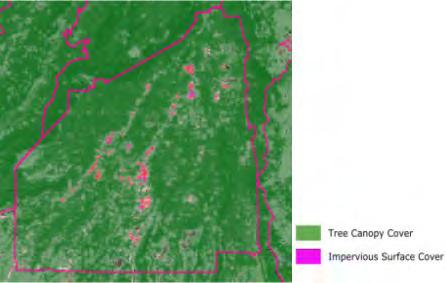
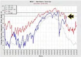
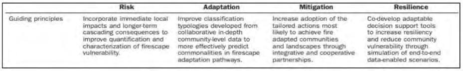
(Top) Figure 1: Risk to resilience spectrum (Smith et al., 2016, p. 140). Used to guide our process of developing mitigation and resilience measures (Bottom left) Figure 2: Percent of Average Precipitation in California, 2017-2018 (Bottom middle) Figure 3: Energy Release Component (ERC) Northern Sierras, Jan 1-Dec 31, 2018 (Bottom right) Figure 4: Tree canopy to impervious surface cover in 2011 (made with itreetools.org virtual mapping tools)
or very high risk of a wildfire hazard.
A Butte County (where Paradise is located) report acknowledged the failure of designated fire evacuation routes in a 2008 fire event, including 3 of the 4 available routes being closed during the evacuation due to the effects of the fire itself (Butte County Grand Jury, 1). These roads that had to be closed had only a single lane going in either direction, sharp curves, and/or areas with high risk of a wildfire hazard in close proximity on either side of the road (3). During the 2008 fire, the only road left open was single-laned and was listed as having “moderate” evacuation potential (5). The report recommended 2 new evacuation routes be designated, and existing routes be upgraded (7). By the time of the Camp Fire in 2018, there were five 2-lane roads and one 4-lane road designated as evacuation routes (Wyloge).
Chapter 7A of the California building code requires that all homes built after the time of the code have to implement fire-resistance-certified measures into the walls, floors, doors, decks and air shafts (Quarles et al. 16-18). Paradise had around 285 homes following this code by the 2018 fire out of the roughly 15,000 total homes in the city (St. John et al.).
Camp Fire’s Impacts on Paradise, CA
During the fire event in Paradise, about 14,000 homes burned. The rate of homes that survived the fire was 4x higher among homes built after the code than before (St. John et al.). In terms of the evacuation routes, the 2018 incident proved to repeat what happened 10 years previous: half of the routes were blocked or closed during the fire, and the remaining three routes were available but traffic jammed (Wyloge).
Cal Fire data (“Burn Injuries” 5) determined that dry fuels to the Northeast of the city were the medium through which the fire reached the city so quickly. However, most of the transmission of the blaze between houses within city limits was not related to vegetation, but rather to wind that carried the embers through the air. In the more isolated areas of the city where homes were farther apart, the dry fuels were the main transmitter.
Paradise Today
As of April 2020, 81 homes had been rebuilt in Paradise according to the county records, with building permits for hundreds more (McDaniel). The Paradise Town Council has vowed to ensure that all new buildings will

strictly comply with the 2008 building codes that contained provisions for fire-resilient construction materials, as well as a promise to redesign the street grid (Siegler, “Disaster Recovery Reforms”).
A citizen testimonial taken after the fire revealed that people were concerned about the proximity of flammable fuels to power lines throughout the town even before the Camp Fire (Siegler, “Disaster Recovery Reforms”). Next to some of the lines is “a layer of pine needles and duff” and “overgrown brush,” as well as narrowly spaced trees (Siegler). What’s even more concerning, says the interviewee, is that the power lines are operated by Pacific Gas and Electric, the same company whose equipment ignited the Camp Fire in the first place (Siegler).
Wildfire Resilience Case Studies
There are some regions of the world that have similar fire vulnerability to Paradise and have already employed fire prevention methods and tested them. Yosemite National Park and Southern Australia have tried to stop fires at the source: both of these locations have extensive prescribed burning programs (Smith et al. 132). Prescribed burns are controlled, intentional fires conducted in areas with an excess of fuels in order to clear those areas and reduce risk of an uncontrolled wildfire. Smith et al. (2016) also lists that both Yosemite and Australia have relocated power lines from fire-prone areas so they don’t accidentally cause one themselves, and so any fires in that location don’t knock out the power (134). However, Southern Australia didn’t see much success in these methods due to that region of Australia being so vulnerable to fires that even mitigation measures often failed. Residents of Southern Australia have taken to simply clearing brush and vegetation in a wide radius around their
Figure 6: The United Kingdom’s reorganization of forests (Smith et al., 2016, p. 133) homes so there isn’t as high of a chance for transmission of fire to the house.

Northern Canada also deals with moderately high fire risk, but they use different preventative methods. They instituted a restriction of access to fire-prone areas during fire season to reduce the amount of human-started fires (Smith et al. 135). They have a historically successful fire suppression system, but it is expensive and the Canadian Wildland Fire Strategy reported diminishing returns as of late (Smith et al. 135).
Discussion
Discussing the Camp Fire’s Impacts
The drought and high winds which created the dry fuels in and around Paradise cannot be controlled. However, the buildup of fuels near buildings can be prevented. Since transmission from the origin of the fire to the city was conducted through narrowly spaced brush that had not burned in recorded history, it can be deduced that the clearing of fuel mass in the forests that are at a high risk for wildfire hazards may reduce the time it takes for the fire to reach a populated area. This extra time could allow for more people to rescue their assets, help others, and evacuate. Additionally, the distance between buildings and these forests was obviously not far enough to prevent transmission. Similar to what Australian citizens do with removing brush from around their homes, a regulated distance between a built structure and continuous fuel loads could reduce transmission risks.
Looking back on the event, it is easy to identify what could have been done to prevent what ended up happening, but in reality, nobody can see every weakness in a system until that weakness becomes a failure. All we can do as designers is to learn from the past events to address the aspects of the event that didn’t work well enough. The combination of the drought, the abundance of fuels in and around the city, and the fact that most of the city’s structures were not following the current fire provision in the building code all render what happened to Paradise ostensibly obvious. Indeed, upon consultation of the US Forest Wildfire Hazard Potential, it becomes clear that a wildfire of a great magnitude was to be expected. However, the city of Paradise failed to implement sufficient measures to mitigate and prevent the harmful effects of the Camp Fire. Thousands of homes burned because they had been built before the fire code was implemented, causing dozens of people to die. Evacuation routes became gridlocked because, despite implementation of the recommendations from the county jury, half of the evacuation routes were
blocked and the remaining three were clogged with traffic, leading to even more loss of life. Clearly, in order to make Paradise more resilient, the street layout needs to be altered, and building codes need to be strictly followed.
Discussing Resilience Measures in Other Places
Across all of the locations we studied with similar wildfire risk and which had implemented fire resilience or mitigation measures, we saw some overlaps in strategies, and among those there were a few which stood out as applicable to Paradise’s resilience plan. Copying the prescribed burns in Yosemite National Park and Southern Australia would address the abundance of fuels around Paradise. Furthermore, Australia’s fuel clearing on the individual level seemed effective, so that could be applied in Paradise as well. There was also overlap in Yosemite and Australia in their relocation of vital infrastructure, such as power lines, out of the fire-prone zones. As Paradise also has concerns about their power lines being affected by or even initiating further fire events, this strategy seems relevant to apply to Paradise’s resilience plan. One method that caught our attention but wasn’t necessarily repeated in multiple locations was the United Kingdom’s strategy of re-organizing their forestry to create artificial obstacles for spreading wildfires. By clumping vegetation together and intersecting forests with roads, there are fewer continuous stretches of fuels in forested areas. This strategy pairs very well with Paradise’s need to rethink their street layout, which is why we decided to include it in our selections despite only being experimented with in one place.
Synthesis/Implementing the Findings into Paradise
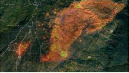
From the Paradise data itself, it seems like the most pressing problems that fit in the scope of this project are reordering the street layout of the town, building according to the fire provision in the building code, and clearing fuels in the forests and near buildings. Figure 7 shows that the fire approached from the East-Northeast direction, which means the propositions for new evacuation routes will focus more on getting out to the South or Southwest. Figure 8 is a topographic and street map of Paradise showing the currently designated evacuation routes. There is a ridge along the Western side of the city, so any Westward evacuation attempts have to either go South before going West, or try to go North. With all this in consideration, Figure 9 shows our proposed changes to the street grid of Paradise. Blue lines indicate new two-laned evacuation routes to be paved. The new route labelled “1” would have to be built across a small ravine with a creek at the bottom, but would save a lot of time compared to going all the way around the ravine and heading towards the direction of the fire. Route “2” would also have to cross a ravine to the West and connect with the Highway 191 route. Green segments in Figure 9 represent evacuation routes that should be upgraded to have one more lane going in the outward direction. With all these evacuation route changes, the total amount of outgoing lanes in the evacuation routes combined goes from 12 to 20 and significantly increases the accessibility of evacuation roads for some parts of the city. In addition to these evacuation route changes, the purple segments represent where new strips of land should be located to break up areas of the town with large patches of continuous forest. These strips could take the form of either paved or dirt roads, or simply strips of land cleared of all wooded vegetation, i.e. trees, bushes, shrubs, and any other woody plants. All would provide breaks in the continuous forest and obstacles for fires moving through the area. These new roads in Figure 9 would also be required to have 50 feet of median on each side of the road with no vegetation, which could be satisfied if there were development alongside the road (as long as that development did not include trees or shrubbery).


(Left) Figure 7: Satellite imagery of the first stages of the Camp Fire, Nov. 7, 2018, as it approaches Paradise, CA from the East. Overlaid on a map of the region East of Paradise. (made with itreetools.org virtual mapping) (Middle) Figure 8: Street map of Paradise, CA with orange arrows representing designated evacuation routes (made with Google Maps) (Left) Figure 9: Street map of Paradise with proposed changes and additions (made with Google Maps)
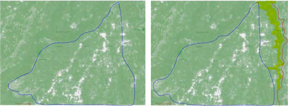
(Left) Figure 10: Tree canopy map of Paradise (made with itreetools.org virtual mapping) (Right) Figure 11: Proposed idea for tree canopy changes in Paradise (made with itreetools.org virtual mapping)
New buildings in Paradise would follow all requirements of Chapter 7A of the California Building Code in terms of fire-resistant construction materials to prevent combustion of buildings from external sources. New vegetation clearing requirements would also be implemented as follows: all shrubs and trees, aside from gardens and plants along the edge of a building, must be removed with a 20 foot clearance in every direction. Beyond that 20 foot line, any tree had to be as far away from that 20 foot line along a horizontal plane as the tree is tall; for example, a 50 foot tree would have to be at least 70 horizontal feet away from a building. This would prevent any burning trees from falling onto the property, and there wouldn’t be any way for burning vegetation to be in close proximity to the building. This 20 foot rule would extend to the power line infrastructure in the town as well.
Evidence from the other locations supports the selection of fuel clearing as a strategy in Paradise, and adds the method of redesigned forestry to our plan. In addition to the vegetation clearing recommendations listed above, we also propose changes to the forestry in the city. Figure 10 shows canopy cover (green) within the city bounds of Paradise (blue line). What we suggest is an area East of Paradise (shown in Figure 11 as the highlighted area), from the end of developed properties all the way to the Western edge of Griffin Gulch (marked in red) to be cleared of all wooded brush. Instead, this stretch of land would become an open meadow or grassy plain. This would dramatically slow and weaken any future fires coming from the East-Northeast direction (as the Camp Fire did) as trees and shrubs were the main vectors of fire transmission in the Camp Fire. This would provide extra time for citizens of Paradise to evacuate while officials controlled the blaze. Additionally, in maintaining it as a vegetated area, the natural beauty of the land to the East of the town would be preserved.
Evaluation of Research Methods
Despite our data collection techniques being limited to internet searches, and no in-person research being conducted, we feel that our data was very comprehensive and fulfilled our intended research objectives. However, it would have greatly benefited our research if we had been able to visit Paradise to see the terrain firsthand. It is difficult to gauge the scale of topographical features and buildings by looking at maps alone. Future work involving these proposals would include actual implementation of the measures, or testing them at other places that experience frequent fires to see if it makes a difference in the town’s resilience.
Conclusions
Using data from government sources, case studies, and assorted reputable reports and articles, we developed a list of proposed wildfire resilience and mitigation strategies to be implemented by the city of Paradise, California following the Camp Fire in 2018. These strategies are: upgraded and added evacuation routes out of the city, additional roads or wooded vegetation-free strips of land intersecting large pockets of continuous forest within the city, a minimum distance away from buildings that wooded vegetation must be. and maintenance of the forests on the Eastern edge of town to provide a buffer zone from fires approaching from that direction.
10.
11.
12. Butte County Grand Jury. “Wildfire and Safety Considerations for Butte County General Plan 2030.” 2009, pp. 1-7, http://www.buttecounty.net/Portals/1/GrandJury/08-09/Grand_Jury_Report_FY08-09-Sec10.pdf. “Burn Injuries.” Cal Fire. n.d. pp. 4-5, https://assets. documentcloud.org/documents/5628194/18-CA-BTU016737-Camp-Green-Sheet.pdf. Dillon, Greg et al. “Wildfire Hazard Potential.” U.S. Forest Service, 2020, https://firelab.org/project/wildfire-hazard-potential. Google Map, https://google.com/maps/. Accessed 17 Jan. 2021 iTree Landscape, https://landscape.itreetools.org/ maps/. Accessed 17 Jan. 2021. McDaniel, Piper. “After the Camp Fire, Paradise is Still Home.” High Country News, 6 Apr. 2020, https:// www.hcn.org/articles/south-wildfire-after-the-campfire-paradise-is-still-home#:~:text=Homeowner%20 Carrie%20Keel%20rebuilds%20one,the%20Camp%20 Fire%20in%202018. Quarles, Stephen L. and Kelly Pohl. “Building a Wildfire-Resilient Home: Codes and Costs.” Headwaters Economics, 2018, pp. 16-20, https://headwaterseconomics. org/wp-content/uploads/building-costs-codes-report. pdf. Siegler, Kirk. “Rethinking Disaster Recovery After A California Town Is Leveled By Wildfire.” NPR, 28 May 2019, https://www.npr.org/2019/05/28/724404528/rethinking-disaster-recovery-after-a-california-town-is-leveled-by-wildfire. Siegler, Kirk. “The Camp Fire Destroyed 11,000 Homes. A Year Later Only 11 Have Been Rebuilt.” NPR, 9 Nov. 2019, https://www.npr.org/2019/11/09/777801169/ the-camp-fire-destroyed-11-000-homes-a-year-lateronly-11-have-been-rebuilt#:~:text=The%20Camp%20 Fire%2C%20named%20for,houses%20burned%20to%20 the%20ground. Smith, Alistair M.S. et al, “The Science of Firescapes, Achieving Fire-ResilientCommunities.” US Forest Service, 2016, pp. 132-140, https://www.fs.fed.us/rm/pubs_ journals/2016/rmrs_2016_smith_a001.pdf. St. John, Paige. et al. “Here’s How Paradise Ignored Warnings and Became a Deathtrap.” Los Angeles Times, 30 Dec. 2018, https://www.latimes.com/local/california/ la-me-camp-fire-deathtrap-20181230-story.html. Wyloge, Evan. “Deadly Traffic: How We Evaluated California’s Wildfire Evacuation Routes.” Desert Sun, 25 Apr. 2019, https://www.desertsun.com/story/news/ environment/2019/04/25/california-wildfire-evacuation-road-capacity-traffic-analysis-methodology-camp-fire/3514552002/.