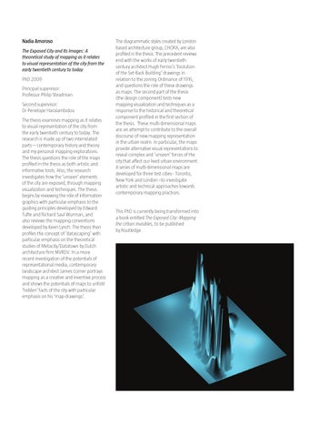
Nadia Amoroso The Exposed City and Its Images: A theoretical study of mapping as it relates to visual representation of the city from the early twentieth century to today PhD 2009 Principal supervisor: Professor Philip Steadman Second supervisor: Dr Penelope Haralambidou The thesis examines mapping as it relates to visual representation of the city from the early twentieth century to today. The research is made up of two interrelated parts—contemporary history and theory and my personal mapping explorations. The thesis questions the role of the maps profiled in the thesis as both artistic and informative tools. Also, the research investigates how the ‘unseen’ elements of the city are exposed, through mapping visualization and techniques. The thesis begins by reviewing the role of information graphics with particular emphasis to the guiding principles developed by Edward Tufte and Richard Saul Wurman, and also reviews the mapping conventions developed by Kevin Lynch. The thesis then profiles the concept of ‘datascaping’ with particular emphasis on the theoretical studies of Metacity/Datatown by Dutch architecture firm MVRDV. In a more recent investigation of the potentials of representational media, contemporary landscape architect James Corner portrays mapping as a creative and inventive process and shows the potentials of maps to unfold ‘hidden’ facts of the city with particular emphasis on his ‘map-drawings’.
The diagrammatic styles created by London based architecture group, CHORA, are also profiled in the thesis. The precedent reviews end with the works of early twentieth century architect Hugh Ferriss’s ‘Evolution of the Set-Back Building’ drawings in relation to the zoning Ordinance of 1916, and questions the role of these drawings as maps. The second part of the thesis (the design component) tests new mapping visualization and techniques as a response to the historical and theoretical component profiled in the first section of the thesis. These multi-dimensional maps are an attempt to contribute to the overall discourse of new mapping representation in the urban realm. In particular, the maps provide alternative visual representations to reveal complex and ‘unseen’ forces of the city that affect our lived urban environment. A series of multi-dimensional maps are developed for three test cities-- Toronto, New York and London –to investigate artistic and technical approaches towards contemporary mapping practices.
This PhD is currently being transformed into a book entitled The Exposed City: Mapping the Urban Invisibles, to be published by Routledge.