

2036
Prepared by Arundhati PP0001417 I Prachi PP0006317
Shubham PPP0009017 I Srinidhi PP0009617
Guided by Bhargav Adhvaryu I Jignesh Mehta
This document is prepared as part of the Development plan studio, Masters in City and Regional Planning Program, 2017, CEPT University
Spring semester 2018
All photographs by authors unless otherwise mentioned
Data from this book can be used and quoted with due acknowledgment to the authors and the studio.
3 2
01 INTRODUCTION 02
03
04 TRANSPORT 05 PHYSICAL INFRASTRUCTURE 06 HOUSING 07 SPECIAL PROJECT 08 PHASING AND COSTING 09 DP ASSESMENT
ROAD NETWORK
ZONING AND DCR
C on TE n TS
CHARACTER oF CITY AnD GRoWTH TREnDS
REGIONAL CONTEXT
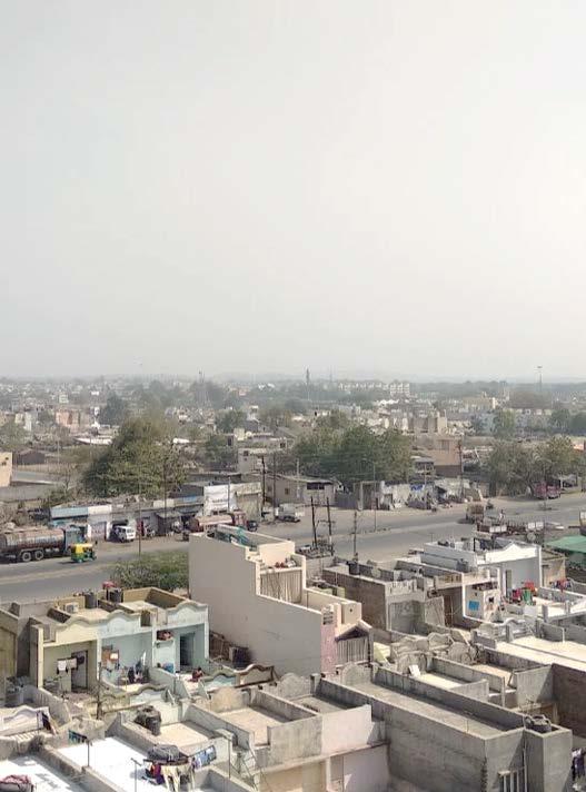
Rajkot is centrally located in the Suarashtra Region in the Aji basin. Spread on the banks of Aji River, the city is well connected not only to major towns within the state but also to neighboring states through strong transportation linkages. Due to its strategic the city is developing as economical, industrial and educational hub for the Saurashtra region.
Boundary of RUDA has 3 urban centers (Municipalities) namely : 01 Jamnagar in the north westerns part, 02 Bhavagar to the southeast and 03 Junagadh in the east.
Planning Area And Administrative Framework :
01 Rajkot Municipal Corporation
02 Rest of RUDA
Rajkot Municipal Corporation (RMC)
The local body of Rajkot city received the status of Municipal Corporation in 1973. It is governed under provisions of the Bombay Provincial Municipal Corporation Act of 1949. no Administrative zones Area(sq.km)
01 Central Zone 22.25
02 West Zone 47.92
03 East Zone 34.68
Total Area 104.8
Rajkot Urban Development Authority (RUDA)
Includes villages surrounding RMC area other than Growth centers within the RUDA Administrative Boundary. It includes 54 villages combining with 686.31sq.km of land.
5
INTRODUCTION :
01
GROWTH OF RAJKOT
Settlement in Rajkot began at 1646 A.D along the river bank of Aji River. Rajkot became the capital of Saurashtra region with the end of the British rule
1872-73 AD
First railway line in Kathiawar was established.
1905 AD
Institutions, residential areas and markets being developed, special school and libraries for girls were established.
1947-1961
Establishment of small scale industrial estate Bhakti nagar (Industrial area)
1961-1990
Main lines of communication by road and rail in Rajkot. Connection to Bhavnagar was developed.Aji industrial estate development Physical growth towards Gondal road and Bhaktinagar due to the development of roads, national highways and industrial estate and new infrastructure.Saurashtra University was developed on the western side

SALIENT FEATURES OF PREVIOUS DP
Development plan of Rajkot 2001

RMC area from 69 sqkm. RUDA boundary from 483 sqkm.
Industrial zones proposed majorly along Ahmedabad , Morbi and Jamnagar corridors
Large parcels of land zoned for recreational uses.
Development plan of Rajkot 2011

Increase in RMC area to 104.85 sqkm. Increase in RUDA boundary to 686 sqkm.
Addition of villages from South-Western region due to InDUSTRIAL growth (Vajdi,Metoda,Devgam,Rataiya)
Increase in Industrial zones along Gondal and Kalavad corridor. Zones reduced along Morbi , Jamnagar and Kuvadava corridors. Industrial growth towards the Aji water body has led to conversion of a part of recreational zone into industrial area.
Increase in public and semipublic areas in 2011 DP in comparison to 2001 DP
7 6
Spatial growth of Rajkot
Existing Landuse plan of Rajkot(2018)
LANDUSE PATTERNS
Residential Land Use

There is considerable variation in residential typologies depending upon the area consumption, density, design of the building, height of the building, age of the structure, etc. Residential development on the west side includes high rises, low rise low density bungalows and low rise multifamily tenements. city, slums are located in central part of the city.More than half of total developed area is in under residential use is under RMC and RUDA includes Gamtal
Commercial Landuse
Rajkot has variety of commercial typologies like-

01 Small Scale Commercial, such as shops or small stores,
02 Medium Scale Commercial, such as shopping centers or commercial strips ,and 03 Large Scale Commercial, such as malls with retails stores, theatres, entertainment centers etc.
A majority of commercial uses in Rajkot fall under Mixed Commercial which includes the Small Scale Commercial uses and Medium Scale shopping centers. Walled City are also characterized by rows of mixed small scale shops along main streets.
Industrial Land Use
Majority of manufacturing industries are located on the south and western side along the state highway such as kalavad road, Gondal road and Ahmedabad road..There are two GIDC within RMC boundary i.e. Aji and Bhaktinagar and one in RUDA boundary i.e. Metoda towards Kalavad.
Gardens, Parks and Open Spaces and Public Amenities and Utilities
Credits: Development plan studio 2018
Race Course, Aji dam, nyari dam, Parduman Park, Lalpari lake, Iswariya park are the examples of the city level open spaces whereas small parks and gardens, urban greens developed by RMC as are the neighborhood level open spaces.
9 8
Existing Builtuse plan of Rajkot(2018)

BUILT USE AND CITY CHARACTER

A predominantly Midrise residential character can be found along Jamnagar Road. From Ghanteswar and Madhapar.
Predominantly Residential Highrise in Rajkot is the stretch from 150’Ring road which has a urban street character with a mix of large scale and small scale commercial activities and highrise residential buildings. along the road.

Kalavad road and Bhavnagar road are the main institutional road in the city.


Gondal road (Kothriya-vavdi) is the major industrial area on the south side in Rajkot city. no development on the eastern side due to physical barriers (railway and waterbodies) and low connectivity.
Credits: Development plan studio 2018

11 10
GonDAL RoAD KALAVAD RoAD 150’FT RInG RoAD
JAMnAGAR RoAD AJI RIVER oLD CITY
APPROACH

STAKEHOLDER SUGGESTIONS
Stakeholder and public consultations were carried out with government officials from RUDA authority, the industrial workers, academician from educational institution such as IPSA and other citizens of Rajkot. The highlights of this consultation touched upon the subjects related to land prices, workers population, growth pattern in the city etc. These inputs were studied and reviewed to include in the formation of proposals for the Development plan 2036.
OCCUPATIONAL PATTERN


Rajkot has a strong manufacturing economic base.The maximum percentage of working population is within the manufacturing and the service sector. The state has also positioned the city as a key node on the proposed “Economic Corridor” along the Surendranagar-RajkotMorbi-Kandla link which adds to Rajkot’s growing economic importance.
“There are no proper road connections in the eastern part of the city.”
“People come here more on Wednesdays and Sundays because the factories remain closed for 2 days.”
POPULATION PROJECTIONS
“Land prices are relatively high in Rajkot because of it’s central location into Saurashtra region.”
A PPROACH FOR Z ONING
As per Census 2011, RUDA area has witnessed an increase in population from approximately 10.94 lakhs in 2001 to 15.35 lakhs in 2011. The estimated population presently (2018) is approximated at 19 lakhs. Assuming the current growth pattern, the projected population in Rajkot would be approximately 36 lakhs in 2036. The built up area assessed for this population would be approximately 59.70 sq.km. for an additional 17 lakh population.
over the past decade a large amount of land in Rajkot has come under development. To accommodate the growing population additional supply of land and built spaces will be required. Shifting from the traditional methodology of restrictive planning , a LIBERAL approach is taken for the Development Plan of Rajkot 2036.This provides more choices for the development thus facilitating more supply than demand.Separate zones need to be allocated for activities causing nuisance like industrial(general & obnoxious) and protection of eco-sensitive areas.Taking road as criteria and completing the second ring road the idea is to densify the development, inside the inner ring road to utilize the already laid infrastructure and vacant land available. Providing high intensity development along the potential corridors. Provision of ring road will open the land for development and development zone are provide inside and outside the ring road with different FSI.

13 12
Chart : Population projection Source : Rajkot Revised DP 2031
]
E XISTING S CENARIO :
Rajkot is situated in the physical center, so it is very well connected by the major roads passing through its spine. These major roads included national Highway 27 and State Highway 23, 24, 25 and 27. So as Rajkot city developed from the intersection of these major roads, it had developed radial road network. Presently the total road lengths is about 2203 km including arterial, sub-arterial, collector and local roads within RUDA and RMC jurisdiction. 150 ft wide road (developed in 2005) is present complete ring which is acting as a by pass of national highway and also connect southern region of the city to the north parts. Due to the growth in recent years, this ring was undergoing congestion, so the part of 2nd ring road was being constructed, having a vision that it may decongest the existing ring and also act as a bypass road for the national highway. Also, the development was seen towards the western region of the city due the in complete road network and physical barriers.


15 ROAD
NETWORK
02
E XISTING T RAVEL PATTERN :
Rajkot is the center for social, commercial, cultural, political, industrial and educational activities for the whole of Saurashtra Region. These activities are mainly concentrated in the central part of the city as well as on Gondal Road, Bhavnagar Road, Kuvadava Road, University Road, Kalavad Road, Raiya Road and Ring road. The major industrial development is on Gondal Road and Bhavanagar Road. The major commercial activities are in the central part of the city and on Kuvadava Road and near Lakhajiraj Station area. The major educational institutions are located Yagnik Road and Kalawad Road. This has resulted in most unsatisfactory relationship between places of working and living areas. A large number of people have to commute from one end of the town to another end to reach their working places. This causes undue delays, traffic jams, accidents, parking problems and unavoidable heavy pressure on public transport during peak hours. According to the primary survey, one can analyse the condition of congestion in the major roads of the inner core.
on the basis of the primary survey done by the transport studio, if we look upon the desire lines, we can analyse that the freight connection are not proper major trips are from the inner core to the outer regions of the city. Also, it can be seen that the incomplete road network are their from north western regions to the eastern parts of the city. Some of the regions are the presence of the natural physical barriers like the Aji dam and river.

P ROPOSED R OAD N ETWORK :
Growth is inclined towards the major roads in any city. Due to incomplete road network and the presence of physical barriers in the middle of the city, much growth is seen only in western region and not in the eastern parts. And also, to divert the freight traffic from the inner part we will need to complete the 2nd ring road. Radial sub-arterial roads are also proposed from the inner existing ring to the new ring to decongest the core traffic and to connects the major regions on the eastern side to the main city areas.
Source : Transport studio

17 16
Source : Transport studio
C OMPLETING S TREET N ETWORK :
There are many streets which are either terminating or not connecting to the main roads which in result gives to a larger and non-walkable block sizes. So, we are completing those street network and connecting the existing roads by laying new roads. This might open up land for development and will provide accessibility.

Collector and Local Streets are to be carved out through TP Schemes
With complete road network and the proposing new street to achieve smaller block sizes and opening up new lands in the eastern areas. So, for the final street layout we will have one new ring road, which is incomplete and also many radial sub-arterial roads which might open up new lands for development. Also, third ring road is introduced which might come up in future development plan and will bind all the radial roads coming from the central part of the city.


19 18
P ROPOSED ROAD LAYOUT:
INTEGRATED PROPOSED ROAD NETWORK WITH EXISTING LANDUSE:
As the road network play a vital role in commencing development. The intersection of major roads acts as the growth nodes. So the proposed road network when overlaid on the existing landuse we can identify that the road network is supporting the existing landuse and also various types of growth nodes can come up in future. These centers are defined according to the current use i.e. Economic Centers where major industries are present ; Regional Centers where the major recreational places are situated ; Community Centers are those centers where major public places like airport, stations and educational institutes are situated; and Potential Centers are those which have a future probability to be developed as growth centers due to presence of factors like lakes, major intersections and proposed projects.


21 20
Proposed Development plan of Rajkot(2036)

The map of zoning proposals along with the area table for Development Plan 2036 incorporating various zoning proposals is given below :
Zoning is one of the important planning tools to manage growth, regulate density .Zoning combined with development regulations determines the supply of developable land and built space available.
Proposed Zone in development plan are:
Core city zone
Retaining existing character- traditional organic character of the old city area. Encouraging compact development through redevelopment and retrofitting through incentivizing.
Urban development zone-1 (UD1)
Urban Development area within the 2nd ring road. Concentration of development within the developed area by utilizing the vacant plots and fallow lands.Mixed use development is allowed only obnoxious industries are restricted. Strengthening of inner infrastructure which will: cost less than laying out new infrastructure. High FSI of (2+1.2) is permitted for the full utilization of land
High intensity-1(HIZ1)

HIZ1 is proposed along the outer ring road and major arterials within the UD1 zone. The Buffer of 500m is given along the road which will give higher accessibility to plots. Mixed use development is allowed only obnoxious industries are restricted. To encourage high density development, high FSI is provided(2+2) is permitted for the full utilization of land.
Urban development zone-2 (UD2)

Urban development zone is proposed outside the 2nd ring road. Less existing growth which will allow the development which prefers less volume. Mixed use development is allowed only obnoxious industries are restricted. Laying of new infrastructure and strengthening the old one. Provide less FSI (1.5+0.5).
High intensity-2(HIZ2)
HIZ2 is proposed along major arterials within the UDZ2 zone, outside the 2nd ring road. The Buffer of 500m is given along the road which will give higher accessibility to plots. Mixed use development is allowed only obnoxious industries are restricted. Medium density charter is envisaged and therefore lower FSI(1.8+0.7) is provided.
23 22
Area distribution in Proposed Zoning
ZONING AND DCR
03 03
General Industrial Zone-(IG)
Small scale industries , logistics , industrial housing, commercial are allowed in IG zone .non hazardous industries are permitted only obnoxious industries are restricted. Expanding the existing industrial zone as Rajkot has potential of more industrial development.FSI of (1.2+0.3) is provided in this zone
Agriculture Zone- (AG)
Promoting primary sector through agriculture based activities. and permitting very less permissible ground coverage(5-15%) .Encouraging very low intensity development and the FSI provided is 0.1-0.45.
Eco sensitive zone
Buffers (100m-200m) around the major water bodies. to protect them and use the buffer for the recreational development and increasing the green cover in the city.
Gamtal –(GM)
Gamtal are the growth areas of the city. Full ground coverage is permitted with Low FSI to retain the existing built form.
Gamtal extension
Buffer of 200m around the Gamtal zone to allow natural growth and the expansion of Gamtal with low FSI.
Proposed Zoning of RUDA area for 2036
Below is the proposed zone table along with the area and permissible uses for Rajkot Development Plan 2036 incorporating various zoning proposals .

25 24
Table : Proposed zoning of RUDA
Proposed FSI for various zones of RUDA area for 2036


In order to encourage growth and to enhance corridor oriented development, the zoning proposals are prioritized in the following order
01 Incentivize development in existing zoned area
02 Encourage development along transit corridors
03 Allow for natural growth around Gamtals while preserving prime agricultural land

Based on existing land uses, currently, about 17.15 sq.km. of area is still vacant and available for development. In order to optimize the utilization of these zoned areas and to encourage development on this serviceable land, it is essential to provide incentives for densification to underutilized areas. The table below identifies the incentives in terms of payable FSI

A case is taken to see city’s built volume and density. A plot has been taken as example with different adjacent roads. Further by providing mandatory margins, developable area has been carved out. With different ground coverage , like 100%,70% and 50%, the structure has been extruded as per permissible and purchasable height. Hence here we see the range of heights coming in different zones like below..

27 26
Table : Proposed FSI of RUDA
Proposed increase in FSI within UDZ1 and HIZ1 zones
Plot margins according to adjacent Road widths
HIGH InTEnSITY ZonE 1 URBAn DEVELoPMEnT ZonE 1
Rajkot has two modes of public transport namely Rajkot Municipal Transport Service (RMTS) and Bus Rapid Transit system (BRTS) . The existing RMTS network covers the major roads within city limits. Presently 45 routes are there which are not sufficient in the peak hours. Moreover, BRTS network runs on 10.7 km of the 150ft Ring Road.


29 TRANSPORT 04
T RA n SP o RTATI on nETW o RK :
The current public transport network is not sufficient for the existing and projected population, there is a need of extending the RMTS and BRTS corridors. According to the proposed zoning, their will be a need of extending the RMTS routes towards the high intensity zones and the industrial zones from Kuvavda to Gondal and from Jamnagar to Kalavad corridor covering the major spines of the whole city. Further, the BRTS network is also need to be extended to serve the existing ring road development and also proposing a new route on 2nd ring road.


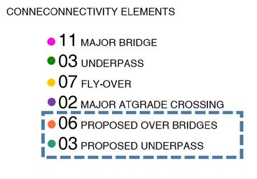
To improve and strengthen the road network of Rajkot there will be need of new underpasses and bridges. So for the proposed road network layout, 6 over bridges and 3 underpasses will be required for the smooth flow of uninterrupted traffic.
31 30 P R o P o SED P
UBLIC
PHYSICAL INFRASTRUCTURE
Infrastructure and public facilities are the basic physical assets required for urban dwellers. Due to rapid population growth, there is constant need for upgradation and proposals of new infrastructure facilities which includes water supply, sewerage and solid waste management.

WATER SUPPLY
For efficient supply of water, the RMC area is divided into east ,west and central regions. The water treatment plants and sources of water supply are accordingly placed. Considering the population of RMC in 2018, the water supply an demand are calculated for each zone. The water demand calculation takes into account water requirements for

According to the present estimated of water demand for RUDA, the water required for an addition of 17 lakh population for 2036 is approximately 404 MLD.

33
05
Source : Infrastructure studio 2018
Gap : 39.72 MLD
PROPOSED
SEWERAGE
Presently nearly 70% of the area within RMC is covered under sewerage network.


Proposal 1: Upgradation of existing sewage treatment plants(STPs)
Presently, there are four sewage treatment plants catering to the RMC area. For the projected population of RUDA, upgradation of the STP is to implemented through this development plan.
Proposals
Proposal 1: Upgradation and provision of new water treatment plants (WTPs)
In order to cater to the future requirement of 404 MLD for RUDA, upgradation and provision of WTPs shall be carried out. Currently, there are five water treatment plants – Aji, Nyari II, Ghanteshwar, Raiyadhar and Ribda .
Upgradation of these treatment plants is proposed to facilitate the present as well as the future population of RUDA area with adequate water supply.
AJI: The existing water treatment capacity of WTP at Aji is 103 MLD. Considering the additional demand, the capacity of this treatment plant is proposed to be increased by 100 MLD.

Ghanteshwar: Similarly there will be an upgradation proposed for the water treatment plant at Ghanteshwar.
one new water treatment plant would be set up at nyari-I to meet the demand of the projected population.
Proposal 2: Upgradation and development of new water supply network
Source : Infrastructure studio 2018
35 34
Currently, approximately 89% area within RMC limit is served by the water supply network. To meet the water demand for existing and future population, in RUDA additional water WTP
LOCATION OF EXISTING STP
SOLID WASTE MANAGEMENT
There are five decentralised plants operating to deal with the vegetable market waste from all over the city. These composting plants cater only to the vegetable market waste and not the household waste. Currently, the municipal solid waste generated in RMC directly does to the landfill site without any treatment.
Landfill site – existing scenario
The current land fill site at Nakarvadi has two cells, which is expected to be filled by the year 2020. Due to its close proximity to the airport and environmental concerns, the site is required for a shutdown.
LOCATION OF EXISTING LANDFILL SITE
SOLID WASTE MANAGEMENT
Proposal 1: New landfill site
Considering the generation of waste for 2036, new land fill site is proposed looking into the following considerations :

01 Availability of land (vacant and public)

02 Distance from the airport (more than 20km)

03 Min 200m away from the water body
04 Ground water table more than 2m.
Proposal 2: Decentralized composting plants
Decentralized plants to be provided instead of a centralized plant for better efficiency. RUDA is proposed to be divided into east west and central regions, for the purpose of the same.
37 36
There is an increasing demand of affordable housing to cater to the growing needs of lower and middle income groups and public housing for BPL..Providing sufficient housing stock for the future population growth and ensuring the sufficient supply of affordable

It is crucial to estimate the number of units to be constructed and amount of land required.So according to current scenario 36% population is below affordable line out of which 24% is living in slums. Based on the population projection more than 2 lakhs dwelling units will be required for public housing to accommodate the additional population by 2036

The land for the public housing can be provided by T.P scheme, RMC land bank, Vacant land and fallow land.The current scheme which provide the public Housing in Rajkot is PMAY.

39
06
HOUSING
Chart : Affordability line
Credits : Housing studio,2018
Units completed under schemes


BSUP : Awas yojna
Rajiv Awas Yojna
PMAY
19653 -Total No. Of completed Dwelling Units
208174 - New DUs estimated to be built
COMPLETED HOUSING PROJECTS UNDER ALL SCHEMS


GOVERNMENT CURRENT SCHEME IN RAJKOT : PMAY

41 40
Credits : Housing studio,2018
LAND FOR PUBLIC HOUSING THROUGH T.P SCHEME
The total land area under T.P Scheme is 47.66 sq.km out of which 0.7 has been already used for Public Housing. Built-up area required for additional population is 6200000m².By mandating 5% of land from T.P scheme for Public Housing ,we can achieve 4200000sq.m built up and 2.3 sq.km of land. Remaining land can be provided by vacant land.

Encouraging affordable housing through modification in development regulations:
01 For public housing Higher-density Development will be encouraged for the More intensive Land Utilization which will reduce the land cost and make the unit affordable.
02 no ground coverage criteria after leaving required margins and common plot.
03 Parking regulations can be relaxed as there is hardly any people who can afford cars.
04 Additional chargeable FSI shall be available at reduced rates.
10% of Jantri rates : For housing unit size upto 50 sq.m
20% of Jantri rates : For housing units above 50 sq.m - 66 sq.m

05 The elevator requirement is modified and buildings are designed to be five-story walkup apartments. which will increase the number of units on plot.
06 Plot under affordable housing will be eligible for FSI upto 3.
07 The developer can be given exemption from municipal charges.
08 Making land conversion process easy.
CoST CoMPonEnTS:
Cost of the land, Cost of construction, and Cost of stamp duty and registration charges paid at the time of property transaction

43 42
key map
map : TP schemes in Rajkot
CURRENT GREEN INFRASTRUCTURE ASSETS
SPECIAL PROJECT
GREEN NETWORKING
Green network includes parks, green streets, waterfronts and green buffer.

Green open spaces such as parks and gardens play indispensable role in maintaining the physical environment and social character of the neighborhoods in the city. They serve as community forums for social interactions, for children to play, for people to entertain and exercise, etc. Green cover along the city streets make the streets more walkable and make the city environment more pleasant and helps reduce heat island effect.
With increase in population, the need for a variety of parks and open spaces is constantly increasing. The proposals in this section are focused on developing a vibrant livable city that has variety of parks, public open spaces within green buffer zone and green streets for its residents providing a healthy and high quality environment.

Considerations
Currently, Rajkot have lack of city level green spaces. About 1.3% of the area identified as parks and gardens in RMC area i.e. 0.68 sq.m. per person. Therefore, there is a need to increase amount of parks and gardens to sufficiently serve the existing population.
According to RMC there are 30 parks and garedens covering an area of 1,97,000 sq.mts. located at different place within a city.
RUDA area contains two major rivers, Aji and nyari along with 12 lakes. Hence there is a need to not only preserves the water body but also enhance it through creating a green buffer along it and increase the recreational and green space within the buffer.
Create a well connected green network of contiguous green spaces which includes parks, gardens, green buffer and green streets. Developing green streets as attractive streetscapes to serve as community.
Above considerations are to combat environmental effects on air quality, ground water recharge, urban heat islands and make the place more livable.
45 44
07
Proposals and Recommendations
Understanding the considerations and the existing level of parks and open spaces in RUDA, a set of proposals and recommendations have been planned to provide adequate recreational spaces catering the needs of the neighborhoods in the city.
Proposal 01 : Adding Green buffer along natural resources
Current scenario :
01 Lack of recreational spaces around water bodies.

02 Dumping of waste on the river banks.
03 need for revival of green space within the city.

Recommendations
RUDA area contains two major rivers, Aji and nyari along with 12 lakes. Development of Green buffer will preserves the water bodies. The development of green buffer of 100-200m around water bodies, considering public and vacant land. It will connect the three main lakes : Aji , nyari and Lalpari.


The project will make the waterfronts accessible to the public with new parks, gardens, plazas and numerous public facilities. Connecting the blue network on the eastern region will encourage development through recreation.
Proposed Green buffer along natural resources
47 46
Lal-pari Lake
Aji river stretch
Proposal 02 : Forming network of green streets and parks

Green shaded streets create attractive streetscape that increase walkability, increase green cover ,reduce heating of paved surface and reduce heat island effect. Thus identification of existing green streets and extending them up to important public open spaces and forming recreational nodes in the city is to be done through green street network. It is proposed to identify and implement approximately 383.3 km of additional Green Street network across the city.
While designing the Green Streets following design principles should be considered:
01 Avenues along the road sides.
02 50% of road side margin area of adjacent plots to be mandated as green space.
03 Built to line ,leaving margin of 6m ( only for arterial roads)
Green street network
Proposal 03 : Increasing Green cover through TP scheme mechanism
Parks and gardens are important amenities to be distributed evenly to ensure that almost every household has access to a park/garden within 5 to 10 minutes walking distance. Currently, Rajkot have lack of city level green spaces. About 1.3% of the area identified as parks and gardens in RMC area i.e. 0.68 sq.m. per person
Current scenario
table
Green areas allocated within TP scheme ranges from 0.5 – 2.0% of total TPS area. It has been observed that few of industrial areas has comparatively less or no green spaces at all.


map : Existing Green cover
table
map : Existing TPS in Rajkot
49 48
: Existing parks and gardens
: Existing TP scheme areas
Recommendation
new parks and gardens can be developed through TP scheme by increasing the mandatory green area which can be provided through TPS mechanism. The consideration is as follow:

40% - Built space
20% - Road construction
05% - Free sell component
05% - Public housing
05% - Public Utilities
05% - Green cover
Implementation of parks and gardens through TP scheme. (Conceptual scenario)


50
Before After
PHASING AND COSTING
COSTING
Improvements proposed in the Development plan 2036 require resources and funds for implementation. Below is a broad estimate of costs for implementation of projects in the following components.
01 Road network
02 Public housing
03Physical infrastructure
04 Recreation
The cost estimation incurred for 2036 is approximately 8607 cr.
Road network.
Implementation of projects under this section lays down a frame work for the development to take place. The cost involved in the construction of new roads with necessary amenities is taken into consideration for cost estimation.
Housing.
The cost component added here is related to public housing i.e for population below the affordability line.


53 52 08
Physical infrastructure.
The total cost estimated includes components in waster supply, sewerage, storm water management and solid waste management.

Water supply cost - The cost estimate for water supply includes
01 Water treatment plants
02 Water distribution stations
03 Water storage facilities Water distribution network.
Sewerage cost - The cost estimate for sewage infrastructure includes
01 Sewage treatment plants
02 Intermediate Pumping stations
03 Sewage network
Funding

01 Chief Minister’s Urban Development Scheme
02 Grants for Development -State Government
03 AMRUT YoJnA - Drainage Work, Park Development, JnnURM
04 HoUSInG SCHEMES- (Central & State Government)

05 PMAY(Current Scheme in Rajkot)
06 Smart houses
Recreational
Special projects like the green buffer, network have been proposed for improving the green network of the city.Estimated cost for development is approximately 115Cr.
Resource Mobilization
Modes through which resources could be generated for covering the costs incurred for implementation of the various projects, proposals and improvements are studied for the development plan 2036.
55 54
PHASING
The development plan 2036 proposed is expected to be developed in two phases.
PHASE 1 (YEAR-2018-2028)
Road network- Kalavad to Ahmedabad-38Km (2nd Ring Road)
Strengthening of road network between 1St ring road and 2nd ring road
Following projects have been divided into phases for the purpose of implementation.
Transportation : BRTS –Extension of existing BRTS from Gondal to Ahmedabad
T.P Scheme will be first implemented inside inner 2nd ring road
Densification of area within inner ring road


Housing:
87,615 public housing unit construction
Industries:
Provision of workers housing
Provision of green spaces
Infrastructure:
Completion of water connection networks.
Upgradation or new landfill site
Completion of sewage network
Upgradation of STP
Upgradation of Aji WTP
PHASE 2 (YEAR-2029-2036)
Road Network : Kalavad to Morbi to Ahmedabad18.3Km (2nd Ring Road)
Construction of 3rd Ring Road
Transportation : new BRTS on 2nd Ring Road from Jamnagar to Kalavad
T.P Scheme will be first implemented outside inner 2nd ring road
Densification of area outside inner ring road
Housing
87,615 public housing unit construction
Industries
Provision of workers housing
Provision of green spaces
Infrastructure
Completion of water connection networks.
Completion of sewage network
Upgradation of STP
1 new WTP at nyari-2
Upgradation of Ganteshwar WTP
57 56
Proposed Development plan of Rajkot(2036)

59 58
09
DP ASSESMENT
REFRENCES
Auda Dp Part 1(Draft Comprehensive Development Plan 2021 (Second Revised)
Auda Dp Part 2(Draft Comprehensive Development Plan 2021 (Second Revised)
Auda Dp Part 3 (Draft Comprehensive Development Plan 2021 (Second Revised)
RUDA Draft Comprehensive Development Plan 2031 (Second Revised)
Part I: Existing Conditions, Studies & Analysis
RUDA Draft Comprehensive Development Plan 2031 (Second Revised)
Part Ii: Planning Proposals And Recommendation
RUDA Draft Development Plan 2031(Second Revised)
PART-III General Development Control Regulations
RMC-TP MAP
http://www.rmc.gov.in/rmcwebsite/tpmap.aspx
Building Regulations Are A Barrier To Affordable Housing In Indian Cities: The Case Of Ahmedabad
Authors:Bimal Patel • Sweta Byahut • Brijesh Bhatha
https://www.hcp.co.in/assets/projects/research/docs/54377Patel_Byahut_Bhatha_HBE.pdf
Dhaka Structural Plan 2016-2035
http://www.rajukdhaka.gov.bd/rajuk/image/slideshow/Dhaka_Structural_Plan.html
Solid waste management rules 2016
61 60
62
