Established in 1997, The Meon Survey Partnership is a high quality land surveying company specialising in measured building surveys, topographic surveys and 3d modelling. The company has a wealth of experience in surveying historic buildings including Grade 1 Listed buildings, Churches, Museums, Manor Houses and even Underground World War II tunnels, in fact we have or could survey any type of building you can imagine. Over the last 3 years we have gained invaluable experience in using Laser Scanners, this “state of the art” technology creates 3 dimensional ‘point clouds’ consisting of hundreds of thousands of data points which are collected in a matter of minutes. This 3d data can then be used for differing types of projects, ranging from capturing a high level of detail for producing large scale 2d drawings to producing 3d models for “rights of light” studies. Rest assured, whatever your survey requirements The Meon Survey Partnership will deliver a high quality and yet efficient service.
Laser scanning 3d point clouds Wireframe models Fully rendered models Walkthroughs Heritage detailing Infringement surveys
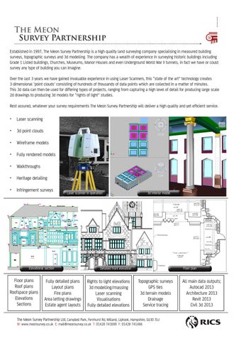
Laser scanner in operation
3d interior model
"THE LIBRARY" GROUND
Elevational section
Floor plans Roof plans Roofspace plans Elevations Sections
Fully detailed plans Layout plans Fire plans Area letting drawings Estate agent layouts
Floor plan
Detailed front elevation
Rights to light elevations 3d modelling/massing Laser scanning Visualisations Fully detailed elevations
Topographic surveys GPS ties 3d terrain models Drainage Service tracing
The Meon Survey Partnership Ltd, Campbell Park, Fernhurst Rd, Milland, Liphook, Hampshire, GU30 7LU W: www.meonsurvey.co.uk E: mail@meonsurvey.co.uk T: 01428 741699 F: 01428 741466
All main data outputs; Autocad 2013 Architecture 2013 Revit 2013 Civil 3d 2013