7 minute read
Anglesea Futures


By Mary Bremner
Concerned Anglesea residents believe the document produced by the State Government, outlining future possibilities for the closed Alcoa mine site, is at odds with the community’s feedback.
Advertisement
Following the closure of Alcoa’s power station and coal mine in August 2015, the Victorian Government’s Department of Environment, Land, Water and Planning (DELWP), together with the Surf Coast Shire and Parks Victoria, commenced consulting with the Anglesea community on the future use of the site. This was titled A nglesea Futures Community Conversation Series (Anglesea Futures).
The vast majority of the 7,000 hectares under discussion was leased land (the Anglesea Heath) that has been surrendered by Alcoa and incorporated into the Great Otway National Park.
There remained a mixture of freehold land held by the Crown, Alcoa and other small private landowners.
Between 2015 and 2018, DELWP conducted a series of meetings and workshops, and concerned citizens contributed to two extensive online surveys.
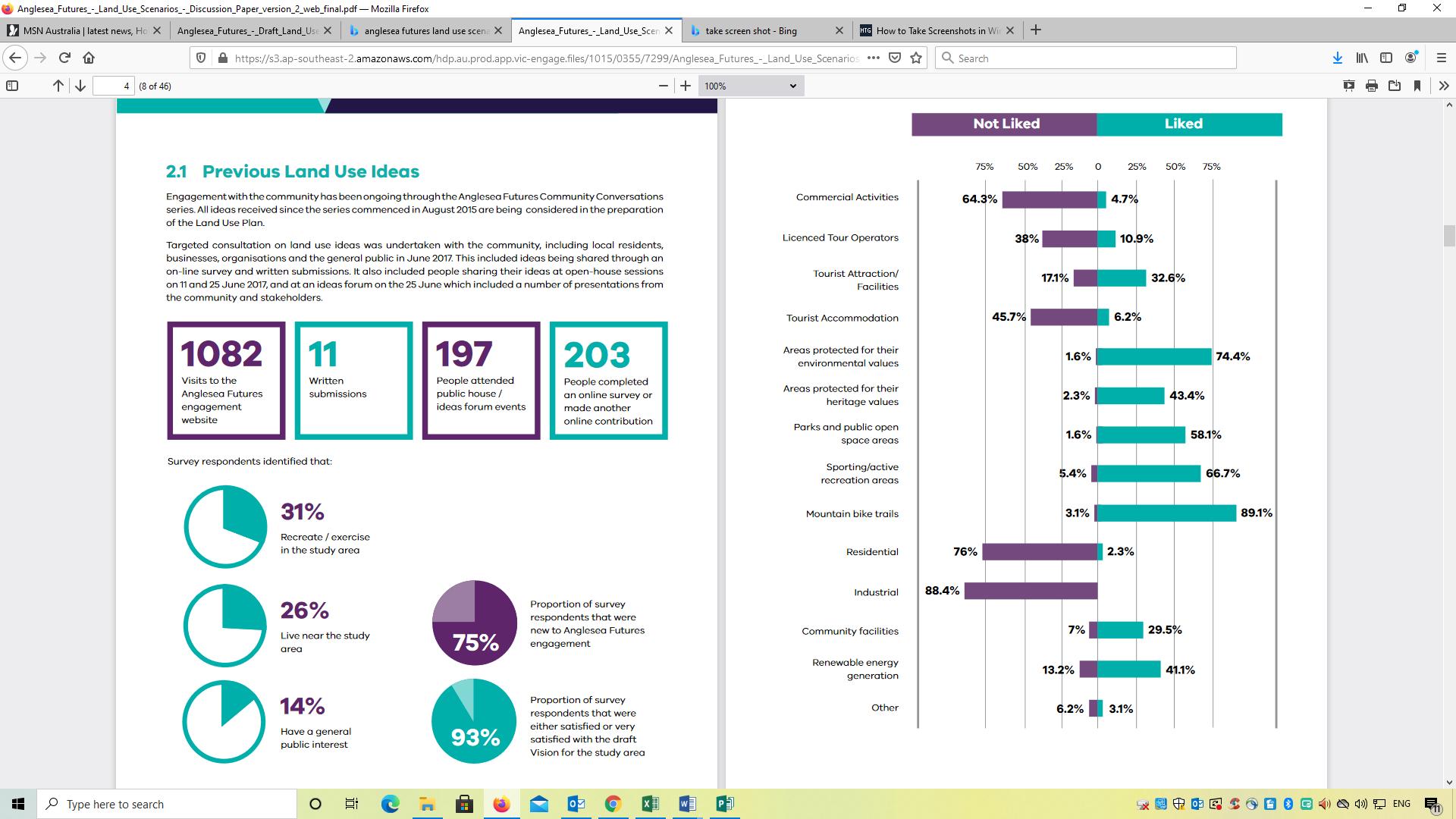
The results of the first community survey were published in a discussion paper by DELWP (see Survey 1 graph on right).
The survey results showed strong opposition to the rezoning of land for residential, retail, commercial and industrial use, tourism accommodation and licenced tour operators.
Alcoa’s power station and coal mine closed in 2015, but the chimney stack remains.
DELWP published the A nglesea Futures Draft Land Use Plan in December 2017. This proposed a range of land uses for each of 10 areas. The culmination of the process came in October 2018 with the publication of the final document, T he A nglesea Futures Land Use Framework.
Considering the report, the areas reserved for conservation are uncontentious and consistent with the
It was at this point that some Anglesea community members who had been involved in the discussions from the beginning, started to feel that there seemed to be a chasm opening up between the community feedback and what was being presented back to them via the Anglesea Futures draft plan. They were surprised to see that the way was being left open for residential land, and commercial tourist and retail operators, despite the clear opposition to these land uses in the survey. In early 2018, DELWP undertook a second community survey based around the 10 proposed areas. This extensive survey received 370 responses from a broad representation of interested parties including the resident population (60%), along with holiday home owners, local businesses, community groups and visitors.
Survey 1 graph shows results from the first community survey (taken from Anglesea Futures Land Use Scenarios Discussion Paper, August 2017).
community feedback. Alcoa had already given up its Crown land lease.
Community concerns surround the DELWP recommendations for private land:
Area 3 (former mining land on the eastern side of the pit) where the Eden Project is now proposed, in keeping with the stated main land use of “eco and adventure-based tourism”. Alcoa and the UK-based educational and environmental enterprise, Eden Project International, presented a concept for a “world-class attraction” to the Anglesea community in May 2019.
Complementary land uses that are recommended include retail, renewable energy, community / visitor facilities, camping and active recreation.
Area 6 (the former power station site) where the document also proposes “eco and adventure-based tourism” with similar complementary land uses to Area 3.
Area 10 (22 hectares on the northern side of the town boundary, encompassing bushland, the Primary School, the Bike Park and the DELWP office) is listed for “conservation, active recreation, rural living, and community and visitor facilities”. Some disbelieving Anglesea residents saw these recommendations as being contrary to the feedback that had come from the community.
Their concern was exacerbated on realising that the A nglesea Futures Land Use Framework only contains a summary of the spread of opinion, rather than tabulated responses to the survey questions, which would show the percentages in favour of the various options for land use. Calls were made for DELWP to release the data, but they refused to do so, citing privacy concerns. The data was ultimately obtained, through a yearlong Freedom of Information process, and confirmed the community members’ suspicions.
In relation to Areas 3 and 6, the data, obtained under FOI and summarised in the following graphs, reveals that 79.2% (Area 3) and 76.8% (Area 6) either did “not support” or “generally not support” the land uses proposed in the Frameworks document.
Regarding Area 10, some residents are suspicious of the term “rural living”, and believe that, contrary to the majority of community opinion expressed in the survey, the recommendations leave the way open for housing development in this area. The data shows that the desire of the majority of the respondents is for conservation of the natural environment for low impact recreation.
An overwhelming 80.5% of those surveyed opposed the use of the land for commercial tourist operations, retail, accommodation and housing development.


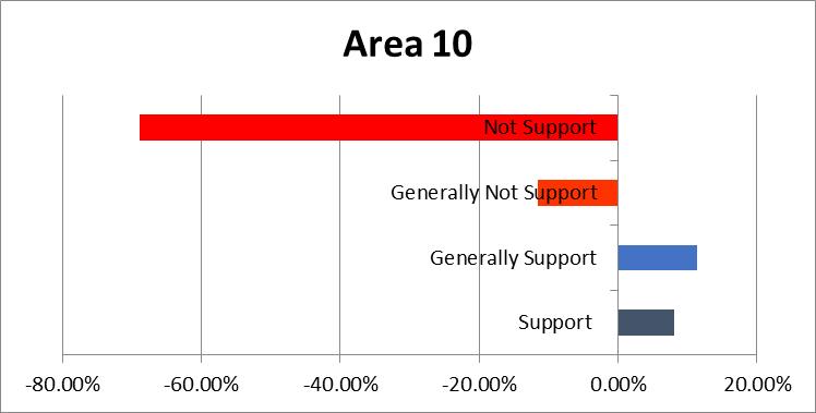
The above graphs were created by concerned community members, to summarise survey data they had obtained from DELWP under FOI.
> continued from page 9
Asked to respond to the issues raised, DELWP Regional Director, Colleen White said, “DELWP is confident that the Plan reflects the variety of views, and balances the, at times, competing preferences for future land use in the area. A key consideration in finalising the plan was to ensure feedback heard across all 12 rounds of engagement was incorporated fairly.” DELWP has always said that community feedback was not the only consideration in the decision-making process. “The Framework has been informed by community/stakeholder feedback, site attributes and policy legislation and data,” explained Colleen White.
“Community/stakeholder feedback has influenced the plan, including the change from residential land uses that were proposed in the Draft Land Use Plan.” Keen to allay any alarm in the Anglesea community, Colleen White added, “Critically, the plan does not approve any new housing, accommodation, retail or tourism development. Any future proposal, if it were to occur, would still need to go through the normal planning assessment process that would include further community engagement.” “In fact, the plan supports significant areas for conservation and only identifies the potential for new rural living in Area 10, which is reflective of existing properties in this area.”
“DELWP is happy to meet with individuals or groups to discuss the Framework, including the consultation process during its development and role going forward,” Colleen White added. How concerned should Anglesea and district residents be about this issue? Very – according to Michael Collins, a local resident who was prepared to go on record for this story. He doesn’t buy DELWP’s reassurances, stating that state government policy overrides local government. The raw survey results have still not been published, but interested readers can obtain a copy by emailing saveanglesea@gmail.com using the subject ‘survey’. “I believe most people would like to see the site retained as a public asset, including the publicly-funded water body, rather than a commercial development,” Michael Collins said. (The proposal is for the government to fund the filling of the mine pit to form a lake.)
“It could be a show case for rehabilitation of a mine site around the world. We just need to get transparency back and have a really constructive community engagement.” Michael Collins is also concerned about the possible domino effect, if development is allowed to take place in Anglesea, contrary to the wishes of the people.

Rehabilitation work is well underway at the former Alcoa mine site.
between conservation and development is being felt right along the Great Ocean Road. This is being further tested with the influx of new residents joining the post-COVID exodus from Melbourne. The consequent demand for housing is putting pressure on the bushland environment that makes our coastal towns so desirable.
For further information and background material, please see links below:
1. DELWP Survey 2: Summary
https://sixthinking.s3-ap-southeast2.amazonaws.com/DELWP-summarydata.pdf
2. DELWP 2
nd Survey Results secured through Freedom Of Information https://sixthinking.s3-ap-southeast2.amazonaws.com/DELWP-rawdata.xlsx 3. Anglesea Structure Plan 2012 https://www.surfcoast.vic.gov.au/files/ assets/public/02-property/building-andplanning/planning/reference-docs/ anglesea-structure-plan-2012.pdf 4. Anglesea Futures Land Use
Framework 2018 https://engage.vic.gov.au/ angleseafutures