7 minute read
Landscape Architecture Portfolio


(13-18)

(19-24)


(1-6) VERDANT MIDTOWN
(7-12) KAMO RIVER PROMENADE
HITCHING POST SQUARE
LOWNSDALE SQUARE


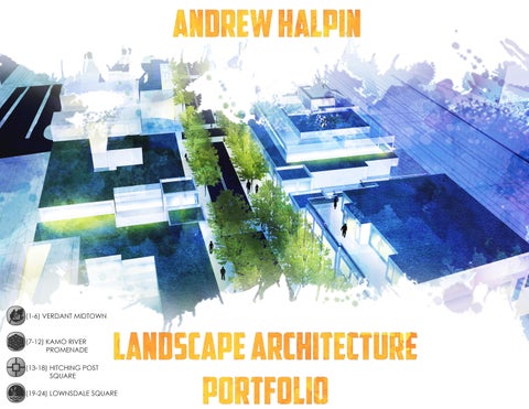
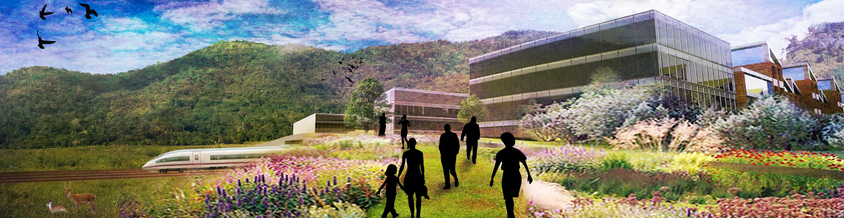
VERDANT MIDTOWN
Connecting a growing downtown with nature
ver the past few years, Springfield has implemented a plan to revitalize the downtown area. Auto repair shops, car dealerships, and strip clubs are being phased out to create a heart for the city.
The studio site we received was just south of Springfield’s downtown, named Booth Kelly, a heavy industrial site that once produced large quantities of lumber. This site required a strong imagination to get past the rugged and dilapidated buildings, which are no longer meeting city code requirements and will need removal.

Our group, saw potential in connecting the downtown to Booth Kelly, creating a transition from dense urban space to a natural landscape surrounding Booth Kelly. The design has three connected districts each with a unique focus to its surrounding context.
The park district looks to connect with the downtown and provide public open space fronted by a new library. The open space will run through all three districts and spill out into the mill-race creek, a recent habitat restored for salmon vitality.

The station district an area I focused on for the term, looks to implement dense, mixed use housing and create connections to important transportation like: pedestrian, bicycle, bus and train networks. This district will contain a train station which connects with a nationwide plan to create a high-speed rail through the northwest corridor, connecting Vancouver BC to Los Angeles CA.
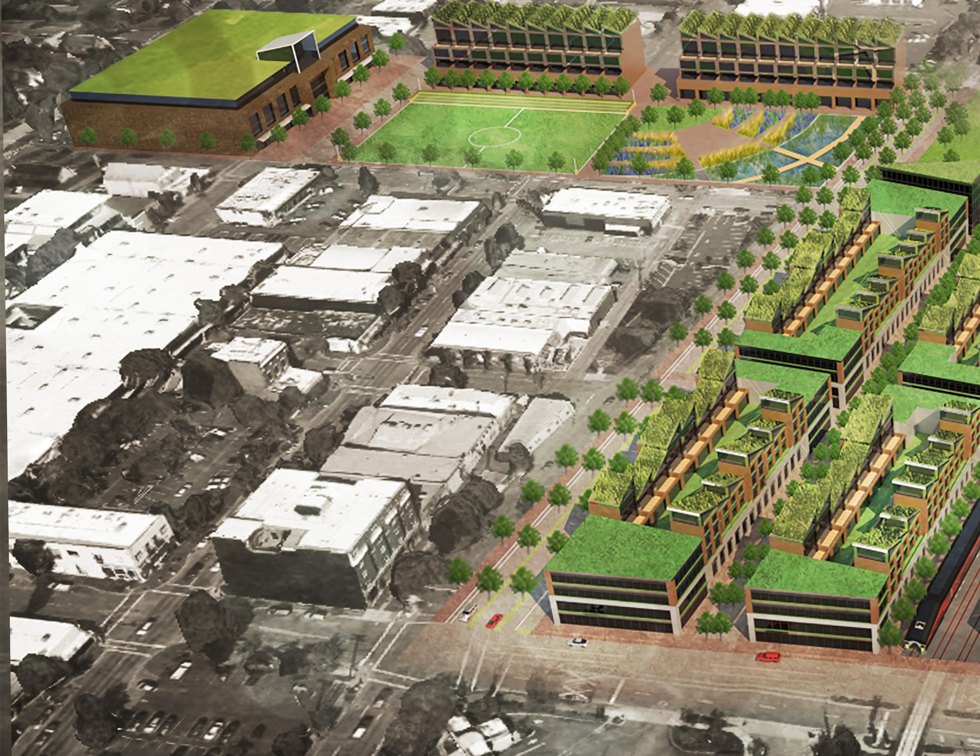
The campus district looks to transform the most characteristic building on the site, with its corrugated metal
and sawtooth roof structure, into an industrial garden. This ancient relic of the lumber industry will display the remaining industrial machinery for visitors to see, helping preserve the historic roots of Booth Kelly. This district has an opportunity to house new light industry, become a corporate campus, for several small businesses looking to expand their product. Continuing off the park blocks will be a land bridge extending over the east/west rail lines. This will allow vehicles to pass over when trains are blocking street level traffic.
Andrew Halpin, Jesse Denny, Sahela Kolb
Springfield, OR

Left Diagrams of the Train, bus and bicycle networks surrounding the site.
Far Left Plan showing locations of the three districts and orientation to the downtown.
Top Right Diagram showing the Land use of the buildings.
Right Detail Plan of the Station district.
Eugene
Springfield
Rail Road
I-5 Willamette River
Booth Kelly
Bus Network
Bike Network
High Speed Rail Vancouver Seattle Portland Springfield San Fransisco San Jose
Los Angeles
Rail Road
I-5 Willamette River Key
1 South A Street
2 Residential roof garden
3 5th Street
4 Train Station
5 Rail Road
6 Land Bridge
7 Section cut
Office
Retail Housing Train Station Booth Kelly

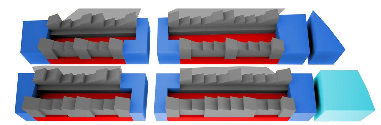
South A street
Shared street Residential roof gardens
Rail road
Left Section showing detail to the site.
Right Perspectives of the shared street, land bridge and residential gardens.


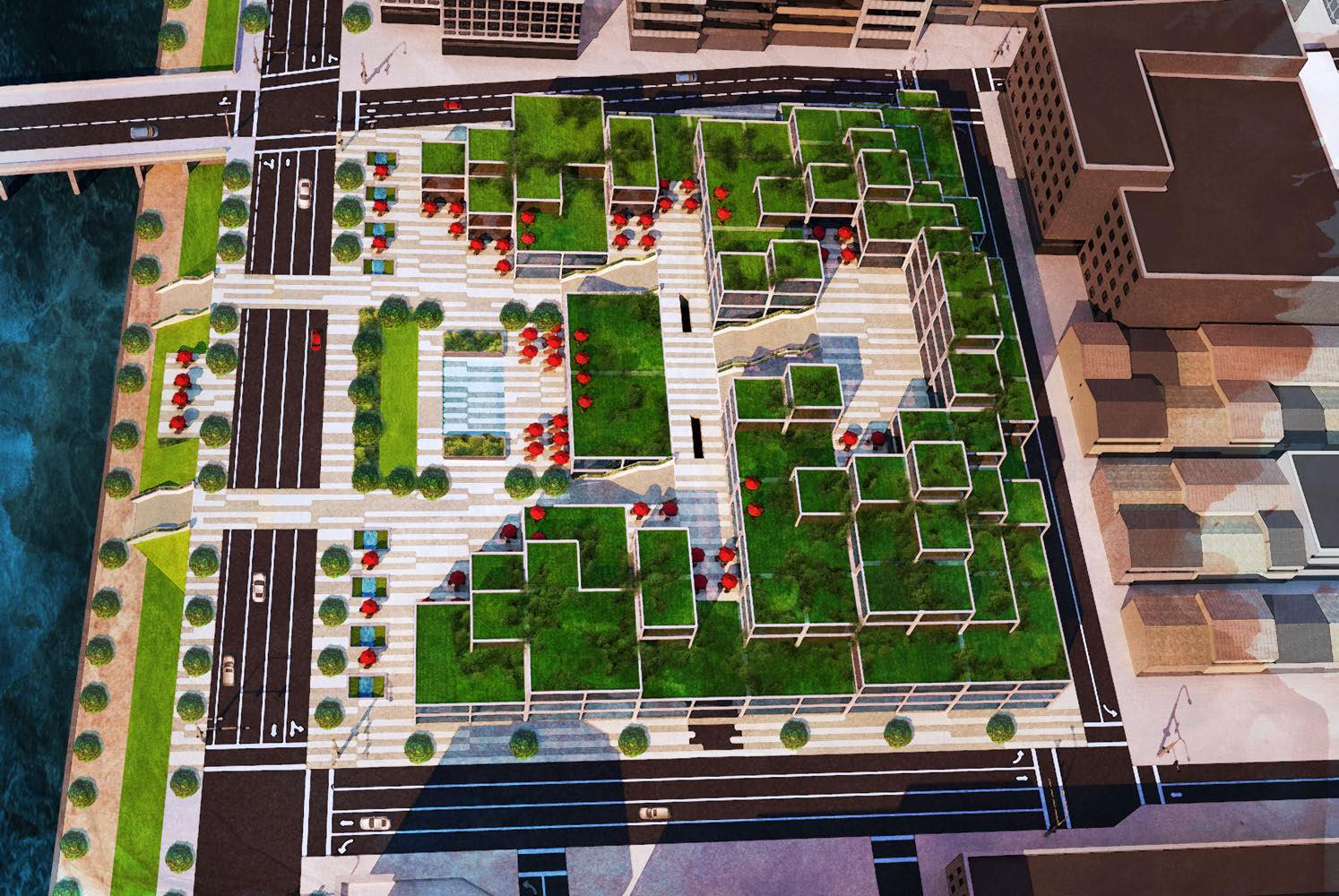
KAMO RIVER PROMENADE
Tying a lush urban space to the Kamo river, Kyoto’s most popular public space.
Andrew Halpin, Connor Falk, Joe Ariente, and Ryan Kiesler
Kyoto, Japan
The Kamo River is Kyoto’s most popular urban space.
The river runs through the heart of the city’s downtown while providing a linear park along both sides of the river. The meandering body of water provides scenic views of Kyoto’s intricate urban network while the visual backdrops of the soaring mountains envelop the city’s urbanity.
Our group saw it necessary to connect to the river, city and the mountains. The architecture of this project looks to borrow the verticality and lushness of the mountains by creating a green terraced structure which steps down towards the river, creating strong visual connections to it from anywhere on the site.
At the heart of the site is a centralized plaza with an interactive fountain which acts as a cool and shady oasis to escape the heat of the city in the summer months.
This site connects with the city’s subway and bus system providing stops on site. These stops were located so when passengers first get off, they arrive at the center of the plaza. At this point they will be surrounded by the cascading vegetation of the structure, still allowing direct views toward the river. The building itself can provide retail, public and commercial use on the lower floors. Moving towards the top of the structure, it can transition to residential housing giving residents some of the best views the city has to offer.
Daikokucho dori
Ohashicho
4 Coffee shop
Left
Plan view of the site with its surrounding context.
Top Perspective standing on one of the roofs of the structure, looking towards the Kamo River.
Right
Axon showing a detailed look at the residential gardens and public parks that are throughout the rooftops of the structure.
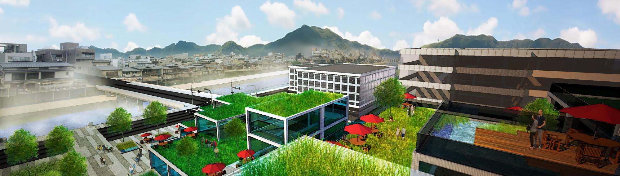

Residential gardens
Public park
Top Left Perspective while crossing the Ohashicho Bridge, giving a view to the whole site

Bottom Section Highlighting the transportation network that crosses though the site.
Kawabata Dori
Kamo River path
Kamo River Sanjo train stop
Plaza
Top Right Perspective within the plaza, looking towards the Train/Bus Station


HITCHING POST SQUARE
A detailed look at Constructing a plaza for the Eugene farmers market.
Andrew Halpin and Sara Sellers
Eugene, OR
This project had us take a finished schematic plaza design of the Eugene farmers market and create a construction document set for how this plaza could be built. Discovering the intricate detail that goes into construction documents, we learned how to design at a small scale. While finding out, through trial and error, how to overcome constraints and obsolesces that occur when considering grading, drainage, city code, electrical layout, and planting design.


LOWNDSDALE SQUARE
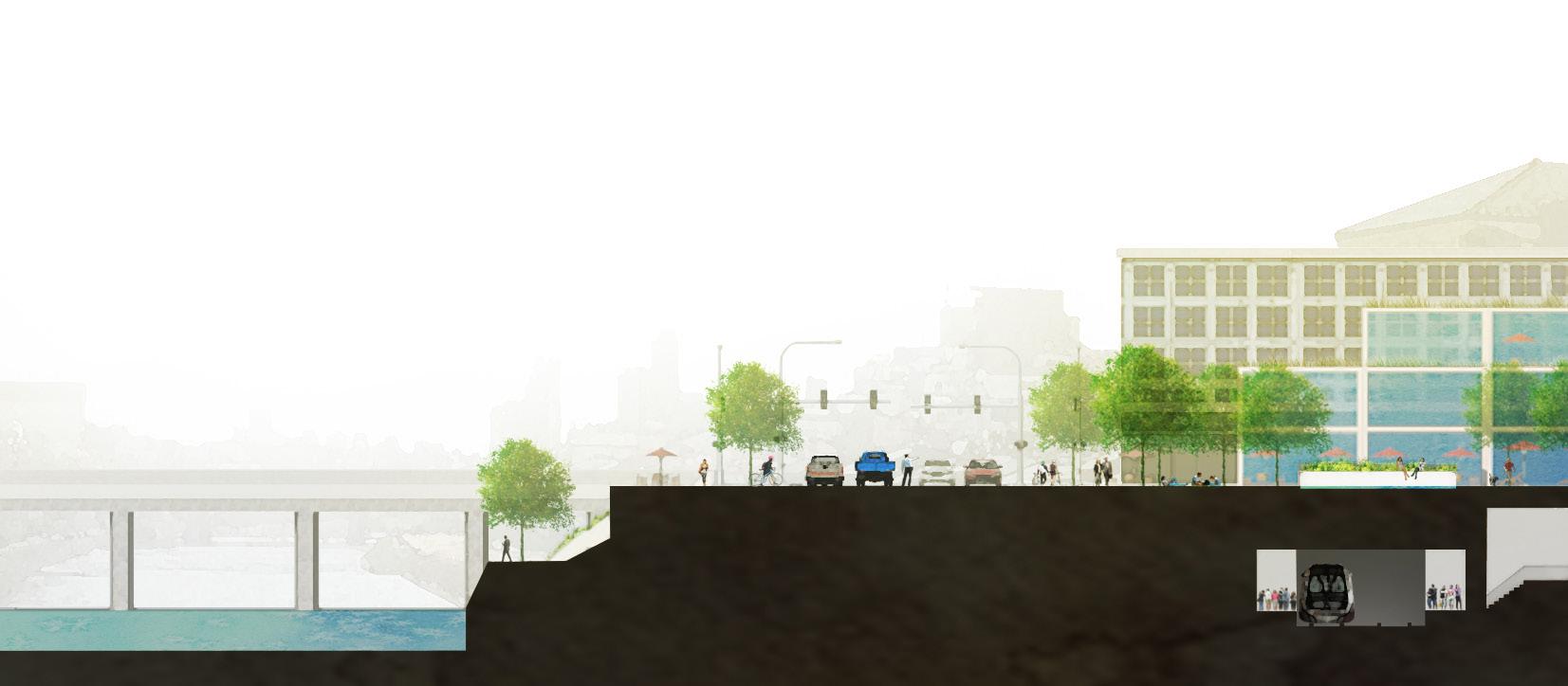
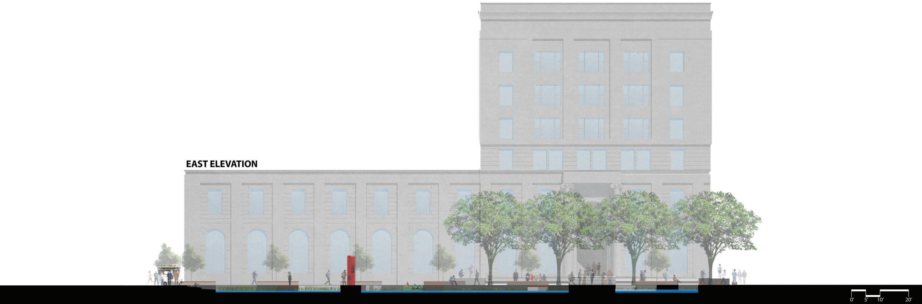
ownsdale Square, just above Portlands north park block’s, looks to continue the structure of this popular open space system. The site is named after the creator of Portland’s park block’s (Daniel Lownsdale). East of the square has become the new campus location of the Pacific Northwest College of Art (PNCA).

Drawing vertical axis from the Park Blocks and horizontal ones from columns on the PNCA building, a simple grid was used to design the form of the plaza. This Influenced the location of circulation paths, the wetland Bio-swale, trees, and other design elements.


The Plaza is a flexible space that can cater to the PNCA’s needs as well as the city’s. Usage such as art galleries, outdoor classrooms, and social gathering space are what will keep this space ideal for the art students. Lowering the plaza down to street level can provide easy access to mobile food carts allowing the plaza to become a popular lunch spot for students as well as anyone who lives or works in this area.
The southern and northern halves of the plaza look to create two distinct micro-climates that can control the temperature through the seasons. The southern half has large shade trees ideal for cooling this space in the summer while the northern half is open allowing for direct sunlight to warm this side in the cooler months of fall and spring. The temperature difference from the sun to shade can be as much as 10 degrees to make a distinct difference with seasonal weather.
Key
1 Food Carts
2 Terraced Lawn
3 Lee Kelly Sculpture
4 Flexible Plaza
5 Retention Wetland
7 Bike Path
8 Bosque
9
10
11
6 Boardwalk
Entrance/Outdoor Class
Wading Pool
ADA Ramp
Providing a extension of Portland’s North Park Block system.
Andrew Halpin
Portland, OR


Plan of Lownsdale Square.
Bottom Left Process diagram.
Right Perspective of the plaza through the seasons.
The city of Portland’s unprecedented application of on-site storm water treatment was an important design consideration for the plaza. Many streets take the storm water and direct it into small boxes on the side of the streets. This application begins to feel like an afterthought in the city where this process should be celebrated when possible. The


8”x8”


Stepped Lawn
Boardwalk
Park Block pavers
Scupper
retention wetland in Lownsdale square looks to break that mold and treat the on-site storm-water in one large swale where it becomes the heart of the plaza. The natural elements of the wetland contrast the urban materiality of the plaza, blurring the lines between city and nature.
Wetland Lee Kelly sculpture
Acer Rubrum bosque
PNCA entrance
Wading pool
Far Left
Axon diagram showing the programmatic elements of the plaza.
Left
Detail of the wetland Bioswale.
Bottom Right Section cutting through the plaza.