Below Bennett & Francis celebreate 100 years of surveying excellence, helping to create some of Brisbane's most noteworthy projects.
bENNETT & fRANCIS
CELEBRATING
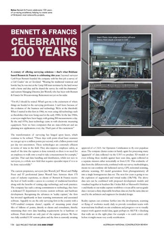
Insert Photo: Auto edge-extraction software Below: Point clouds overlaid in CAD
100 YEARS
A century of offering surveying solutions – that’s what Brisbane based Bennett & Francis is celebrating this year. Licensed surveyor Cyril Fryar Bennett founded the company with his first job a survey of a Girl Guides’ site at Cleveland. “Wearing his traditional waistcoat and bowler hat, he was met at the Camp Hill tram terminus by the land owner with a horse and dray and he shared the survey fee with his chainman,” said current Managing Director, Jim Worrell, who has been with Bennett & Francis for 50-years-strong. Retirement not yet on his radar. “I’m 69, I should be retired. What’s got me is the excitement of where things are headed in the surveying profession. I can’t leave because of the evolution of the business and technology. We’re at the threshold. When I started in this firm in 1966, we were using old technology such as theodolites that were being used in the early 1900s. In the late 1960s, a surveyor might have been happy with getting 200 measurements a day. By the mid 1970s, laser technology came in with electronic measuring equipment. Now we have computers that are state-of-the-art and are planning new applications every day. That’s part of the excitement.” The transformation of surveying has hinged upon lasers, which continue to be refined. “These days with point cloud laser scanners we can get up to a million points per second, with a billion points total per day not uncommon. These technologies are extremely efficient in terms of time in the field. They also improve employee safety, as much of the time the capture is done remotely so there is no need for an employee to walk onto a road to take a measurement for example,” said Jim. That said data handling and distribution, whilst not new to surveyors, is a whole new field that requires specialist input if it is to be done successfully.” The current proprietors, surveyors Jim Worrell, Jeff Wood and Phillip Pozzi and IT professional James Worrell have between them 175 years of industry experience, so clients of Bennett & Francis receive the best of both worlds – access to a century of traditional knowhow along with the benefits of cutting edge technology and work practices. The company has such a strong commitment to technology, they have a dedicated IT department to oversee custom software and hardware development. Recognising the advances in ‛reality capture,’ the firm has invested significantly in laser scanning instruments and associated software. Arguably we are the only surveying firm in the country with a ‘GPU-enabled compute cluster’, capable of streaming point cloud files of billions of points, directly to clients and consultants, thereby minimising their own data handling requirements be it hardware or software. Point clouds are only part of the capture process. We have two fully certified UAV remote pilots and the firm is currently awaiting 136 QLD PROJECT FEATURE 310 ANN STREET
approval of a CASA Air Operators Certification to fly over populous areas. The compute cluster comes in handy again for processing many ‘gigapixels’ of data collected via the UAV’s to produce 3D models or even refining these models against laser scan data, again collected in a separate mission either terrestrially or from UAV. This avalanche of data from the different tools, combined with our survey methodologies, means we can combine old fashioned survey, GPS, terrestrial scanning, airborne scanning, 3D model generation from photogrammetry all into a single homogeneous data set. The next few years is going to see the explosion of augmented and virtual reality (AR/VR). The above data sets can be combined with proposed development models and visualised together in headsets like Oculus Rift or Microsoft’s Hololens – and thanks to our reality capture workflows – it can all be survey-grade data – not just a shiny disposable brochure data set, but the same data set used by the architects and engineers for detailed design. Reality capture can continue further into the development, scanning or flying of worksites nearly daily to provide consultant teams with near-real time feedback on site conditions and progress – or to visually inspect work against model data, again perhaps in AR/VR – checking that walls are in the right place for example – to catch errors early before it might mean very costly rectification. AUSTRALIAN NATIONAL CONSTRUCTION REVIEW