Charts from the Past with Blair Trewin
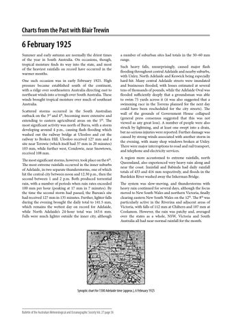
6 February 1925 Summer and early autumn are normally the driest times of the year in South Australia. On occasions, though, tropical moisture finds its way into the state, and most of the heaviest rainfalls on record have occurred in the warmer months. One such occasion was in early February 1925. High pressure became established south of the continent, with a ridge over southeastern Australia directing east to northeast winds into a trough over South Australia. These winds brought tropical moisture over much of southeast Australia. Scattered storms occurred in the South Australian outback on the 3rd and 4th, becoming more extensive and extending to eastern agricultural areas on the 5th. The most significant activity was north of Burra, with a storm developing around 4 p.m., causing flash flooding which washed out the railway bridge at Ulooloo and cut the railway to Broken Hill. Ulooloo received 127 mm and a site near Terowie (which itself had 37 mm in 20 minutes) 103 mm, while further west, Condowie, near Snowtown, received 108 mm. The most significant storms, however, took place on the 6th. The most extreme rainfalls occurred in the inner suburbs of Adelaide, in two separate thunderstorms, one of which hit the central city between noon and 12.30 p.m., then the second between 1 and 2 p.m. Both produced torrential rain, with a number of periods when rain rates exceeded 100 mm per hour (peaking at 17 mm in 7 minutes). By the time the second storm had passed, the Bureau’s site had received 127 mm in 135 minutes. Further, lighter falls during the evening brought the daily total to 141.5 mm, which remains the wettest day on record for Adelaide, while North Adelaide’s 24-hour total was 163.6 mm. Falls were much lighter outside the inner city, although
a number of suburban sites had totals in the 50–60 mm range. Such heavy falls, unsurprisingly, caused major flash flooding throughout central Adelaide and nearby suburbs, with Unley, North Adelaide and Keswick being especially hard-hit. Many central Adelaide streets were inundated and businesses flooded, with losses estimated at several tens of thousands of pounds, while the Adelaide Oval was flooded sufficiently deeply that a groundsman was able to swim 75 yards across it (it was also suggested that a swimming race in the Torrens planned for the next day could have been rescheduled for the city streets). The wall of the grounds of Government House collapsed (general press consensus suggested that this was not viewed as any great loss). A number of people were also struck by lightning, and at least one swept into a drain, but no serious injuries were reported. Further damage was caused by strong winds associated with another storm in the evening, with many shop windows broken at Unley. There were major interruptions to road and rail transport, and telephone and electricity services. A region more accustomed to extreme rainfalls, north Queensland, also experienced very heavy rain along and near the coast. Innisfail and Babinda had daily rainfall totals of 433 and 416 mm respectively, and floods in the Burdekin River washed away the Inkerman Bridge. The system was slow-moving, and thunderstorms with heavy rain continued for several days, although the focus moved to New South Wales and northern Victoria, finally clearing eastern New South Wales on the 12th. The 8th was particularly active in the Riverina and adjacent areas of Victoria, with falls of 112 mm at Chiltern and 107 mm at Coolamon. However, the rain was patchy and, averaged over the states as a whole, NSW, Victoria and South Australia all had near-normal rainfall for the month.
Synoptic chart for 1500 Adelaide time (approx.), 6 February 1925
Bulletin of the Australian Meteorological and Oceanographic Society Vol. 27 page 36