1 minute read
ADDITIONAL WORKS


HOMELESS DOMESTICITY IN NYC’S INNER RING //
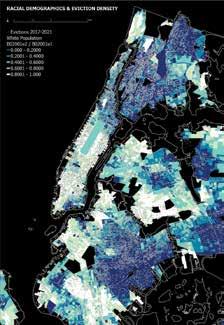
My series of maps work to display the geography of homelessness in New York City’s Inner Ring. Tying together rent burden, services (both public and private) available to the homeless population, racial demographics, evictions, and homeless shelter intake I highlight what areas that need services the most do or don’t have them as well as the relationship between race and the areas of the Inner Ring that are more prone to homelessness. I also wanted to display the places in which the homeless population may spend their time and stay at night as a good portion of them prefer to not stay in shelters due to violence and low privacy. There is an obvious connection between race and people struggling to pay their rent, with the whiter, less diverse community districts having the lowest percentage of population using more than 35% of their income on housing. Because it is communities of color struggling with rent and facing higher eviction rates, those communities of color are more likely to experience homelessness.
Advertisement


MATERIAL TRANFORMATIONS // This exercise in analog and digital skills invloved analyzing and physically tranforming a fragment of natural material. After scanning the stump of wood it was then cut, sanded, chopped up, and glued back together to build a new form. Extra material was then added to highlight natural elements of the stump.