S06 ORME 7 2012 E&P 01_Layout 1 24/10/2012 16:48 Page 34
E&P
Proper integration of the acquisition, processing and interpretation of high-resolution and high-density borehole and surface seismic data can significantly enhance the quality of both datasets for optimised reservoir characterisation, writes Ghiath Ajlani of CGGVeritas.
Integrating borehole and surface
seismic data F
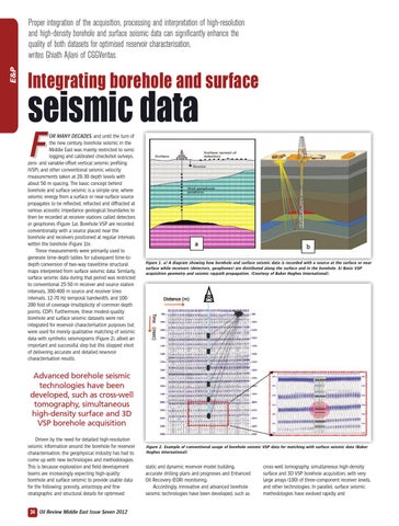
OR MANY DECADES, and until the turn of the new century, borehole seismic in the Middle East was mainly restricted to sonic logging and calibrated checkshot surveys, zero- and variable-offset vertical seismic profiling (VSP), and other conventional seismic velocity measurements taken at 20-30 depth levels with about 50 m spacing. The basic concept behind borehole and surface seismic is a simple one, where seismic energy from a surface or near-surface source propagates to be reflected, refracted and diffracted at various acoustic impedance geological boundaries to then be recorded at receiver stations called detectors or geophones (Figure 1a). Borehole VSP are recorded conventionally with a source placed near the borehole and receivers positioned at regular intervals within the borehole (Figure 1b). These measurements were primarily used to generate time-depth tables for subsequent time-todepth conversion of two-way traveltime structural maps interpreted from surface seismic data. Similarly, surface seismic data during that period was restricted to conventional 25-50 m receiver and source station intervals, 300-400 m source and receiver lines intervals, 12-70 Hz temporal bandwidth, and 100200 fold of coverage (multiplicity of common depth points, CDP). Furthermore, these modest-quality borehole and surface seismic datasets were not integrated for reservoir characterisation purposes but were used for merely qualitative matching of seismic data with synthetic seismograms (Figure 2), albeit an important and successful step but this stopped short of delivering accurate and detailed reservoir characterisation results.
Figure 1. a) A diagram showing how borehole and surface seismic data is recorded with a source at the surface or near surface while receivers (detectors, geophones) are distributed along the surface and in the borehole. b) Basic VSP acquisition geometry and seismic raypath propagation. (Courtesy of Baker Hughes International).
Advanced borehole seismic technologies have been developed, such as cross-well tomography, simultaneous high-density surface and 3D VSP borehole acquisition Driven by the need for detailed high-resolution seismic information around the borehole for reservoir characterisation, the geophysical industry has had to come up with new technologies and methodologies. This is because exploration and field development teams are increasingly expecting high-quality borehole and surface seismic to provide usable data for the following; porosity, anisotropy and fine stratigraphic and structural details for optimised
34 Oil Review Middle East Issue Seven 2012
Figure 2. Example of conventional usage of borehole seismic VSP data for matching with surface seismic data (Baker Hughes International).
static and dynamic reservoir model building, accurate drilling plans and prognoses and Enhanced Oil Recovery (EOR) monitoring. Accordingly, innovative and advanced borehole seismic technologies have been developed, such as
cross-well tomography, simultaneous high-density surface and 3D VSP borehole acquisition, with very large arrays (100) of three-component receiver levels, and other technologies. In parallel, surface seismic methodologies have evolved rapidly and