RESEARCH
Aerial
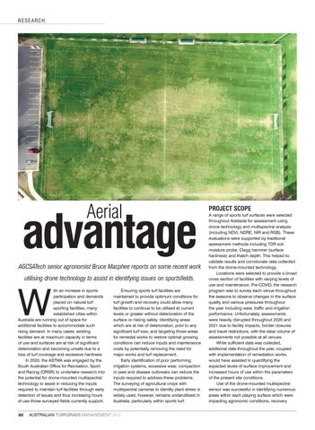
advantage AGCSATech senior agronomist Bruce Macphee reports on some recent work utilising drone technology to assist in identifying issues on sportsfields.
W
ith an increase in sports participation and demands placed on natural turf sporting facilities, many established cities within Australia are running out of space for additional facilities to accommodate such rising demand. In many cases, existing facilities are at maximum capacity in terms of use and surfaces are at risk of significant deterioration and becoming unsafe due to a loss of turf coverage and excessive hardness. In 2020, the ASTMA was engaged by the South Australian Office for Recreation, Sport and Racing (ORSR) to undertake research into the potential for drone-mounted multispectral technology to assist in reducing the inputs required to maintain turf facilities through early detection of issues and thus increasing hours of use those surveyed fields currently support. 60
Ensuring sports turf facilities are maintained to provide optimum conditions for turf growth and recovery could allow many facilities to continue to be utilised at current levels or greater without deterioration of the surface or risking safety. Identifying areas which are at risk of deterioration, prior to any significant turf loss, and targeting those areas for remedial works to restore optimal growing conditions can reduce inputs and maintenance costs by potentially removing the need for major works and turf replacement. Early identification of poor performing irrigation systems, excessive wear, compaction or pest and disease outbreaks can reduce the inputs required to address these problems. The surveying of agricultural crops with multispectral cameras to identify plant stress is widely used, however, remains underutilised in Australia, particularly within sports turf.
AUSTRALIAN TURFGRASS MANAGEMENT 24.3
PROJECT SCOPE A range of sports turf surfaces were selected throughout Adelaide for assessment using drone technology and multispectral analysis (including NDVI, NDRE, NIR and RGB). These evaluations were supported by traditional assessment methods including TDR soil moisture probe, Clegg hammer (surface hardness) and thatch depth. This helped to validate results and corroborate data collected from the drone-mounted technology. Locations were selected to provide a broad cross section of facilities with varying levels of use and maintenance. Pre-COVID, the research program was to survey each venue throughout the seasons to observe changes in the surface quality and various pressures throughout the year including wear, traffic and irrigation performance. Unfortunately, assessments were heavily disrupted throughout 2020 and 2021 due to facility impacts, border closures and travel restrictions, with the ideal volume of assessments not possible at all venues. While sufficient data was collected, additional data throughout the year, coupled with implementation of remediation works, would have assisted in quantifying the expected levels of surface improvement and increased hours of use within the parameters of the present site conditions. Use of the drone-mounted multispectral sensor was successful in identifying numerous areas within each playing surface which were impacting agronomic conditions, recovery