
6 minute read
International Insights: The Great Outdoors


The articles featured in Technical Insights are to prompt thought and discussion to assist our members' question and evaluate their understanding of the technical requirements of Australian Standards and other national/international source material. Technical Insights is to intended to provide background information, a different viewpoint, a perspective from an individual with lived experience of disability or to prompt further discussion and/or research by you as an access professional. 50mm high and ideally spaced 1200mm apart (when they extend the full width of the trail) slope must not exceed 1:8
by Paul Eltringham Stonehenge Consulting Pty Ltd
Advertisement
Paul Eltringham is the founding owner/operator of Stonehenge Consulting Pty Ltd based in Geelong, established in 2008. Paul has over 25 years experience in Building Surveying (commercial and domestic buildings) and is qualified as Level 1 (unrestricted) in Victoria and Qld. Paul is also a qualified Access Consultant (Cert IV completed 2016) and is an Associate Member of the Association of Consultants in Access Australia. Paul is now mainly involved as an Access Consultant to other building surveyors, builders, architects and developers.
UNITED STATES ACCESS BOARD – OUTDOOR DEVELOPED AREAS
The Accessibility Standards for Federal Outdoor Developed Areas developed by the United States Access Board defines a trail as 'a pedestrian route primarily for outdoor recreational purposes. Pedestrian routes that are developed primarily to connect accessible elements, spaces and buildings within a site are not a trail.
Trails
The technical requirements for trails as defined for the (USA) Federal Outdoor Developed Areas standard are briefly summarised below:
• Surfaces of trails, passing spaces and resting intervals must be firm and stable
• Clear tread width of the trail must be 915 mm
• Passing spaces at least 1525 x 1525mm wide must be provided at maximum 300 metre intervals
• Tread obstacles on the path can be no more than
• Openings (e.g. grates and decking gaps) must be small enough that a sphere more than 13mm cannot pass through
• Trail running slopes (i.e. grade) can be constructed up to 1:20 for any distance. However, to accommodate steeper terrain trails can be designed with shorter segments that have a grade and length as shown in the table below, with resting intervals at the top and bottom of each segment.
No more than 30% of the total trail length may exceed a running slope of 1:12 and the running
• Cross must not exceed 1:20 unless the surface is paved and elevated above natural ground when the cross slope must be no steeper than 1:48 (2%)
• Resting intervals of at least 1525 mm long x 915 mm wide must be provided any time the running slope exceeds 1:20 (5%)
• Gates in paths must have a clear width of minimum 915 mm minimum
• Objects must not protrude into the trail tread up to a height of 2030mm high (e.g. signs, rock walls, tree branches.
Outdoor Recreation Access Routes
The Access Board goes on to define Outdoor Recreation Access Routes (ORARs) as 'a continuous, unobstructed path that is intended for pedestrian use that connects accessible elements, spaces, and facilities within camping and picnic facilities and at viewing areas and trailheads'.
At viewing areas, at least one ORAR must connect accessible parking spaces or other arrival points that serve the viewing area with accessible elements, spaces, and facilities provided within the viewing area.
At trailheads, at least one ORAR must connect:
• Accessible parking spaces or other arrival points serving the trailhead
• The starting point of the trail
• Accessible elements, spaces, and facilities provided within the trailhead
The same elements as described above for trails are also defined for ORARs, with some differences in tolerances and dimensioning, allowing trails to have a steeper and rougher terrain, whereas interconnecting routes between accessible facilities at the trail heads are to have a greater level of accessibility.
The Accessibility Standards for Federal Outdoor Developed Areas also provides accessible design criteria for elements such as trailheads, camping and picnic facilities, viewing areas, fire pits, seating, outdoor showers, pit toilets and beach access.
UNIVERSAL TRAIL ASSESSMENT PROCESS (UTAP)
Chapter 13 of the document Designing Sidewalks and Trails for Access Part II of II: Best Practice Design Guide states that 'Information provided about trails has traditionally been very limited. It usually consists of trail length and a subjective rating such as “easy” or “difficult”. Subjective ratings reveal very little about the actual conditions of the trail. For example, a hiker who uses a wheelchair cannot determine from an “easy” rating whether a trail is wide enough throughout to permit the wheelchair to pass. If the trail is too narrow, the user may have to turn back. This is frustrating for both the hiker using a wheelchair and any hiking companions.'
The Universal Trail Assessment Process (UTAP) is an inventory tool that records accessibility and maintenance information on a trail. The UTAP was designed to meet the information needs of both trail users and land management agencies. The assessment process was developed over a four-year period through the collaboration of US Federal, State, and local land management agencies, as well as trail organizations. The UTAP has been implemented by several agencies and organizations to record trail conditions for access and maintenance information.
The Universal Trail Assessment Process (UTAP) is used to collect data that can be used to provide objective information to users about the conditions of trails. The primary accessibility information recorded for trails includes:
• Trail length;
• Maximum and average cross slopes;
• Maximum and average grades;
• Surface type and firmness;
• Minimum clear width; and
• Average tread width.
The below is an example of a Trail Information Sheet and a Trail Access Information Strip
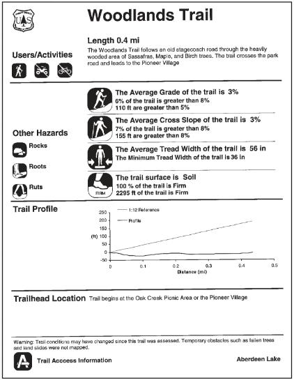
Source: Chapter 13 of Designing Sidewalks and Trails for Access Part II of II: Best Practice Design Guide (2001)
USEFUL USA LINKS
Trail Explorer
www.trailexplorer.org
The Trail Explorer website conveys objective trail information in a unique Trail Access Information format to help trail users make informed decisions about which public lands to visit, and which trails will best meet their interests, abilities and desired experiences. The Trail Access Information summarizes information about various trails throughout the USA including - grade, cross-slope, surface, width, length, obstructions and features. Trail Access Information is generated by using the Universal Trail Assessment Process (UTAP).
Federal Highway Administration
https://www.fhwa.dot.gov/accessibility/
https://www.fhwa.dot.gov/environment/ recreational_trails/publications/
The Accessibility Resource Library of the Federal Highway Administration features information as it relates to the Americans with Disabilities Act (ADA) plus other accessibility resources.
https://www.access-board.gov/ guidelines-and-standards/recreation-facilities/ outdoor-developed-areas
The United States Access Board has developed Standards for Outdoor Developed Areas and issued requirements that now form part of the Architectural Barriers Act (ABA) Accessibility Standards and apply to national parks and other outdoor areas developed by the U.S. federal government. A guide that explains these requirements also is available. The new provisions address access to trails, picnic and camping areas, viewing areas, beach access routes and other components of outdoor developed areas on federal sites when newly built or altered. They also provide exceptions for situations where terrain and other factors make compliance impracticable.
LOCAL INSIGHTS
A quick search on the internet will assist locate accessible walking trails, access to adaptive equipment and creative play options. Some examples that may be of interest include:
https://parks.tas.gov.au/explore-our-parks/ know-before-you-go/access-friendly
https://www.nationalparks.nsw.gov.au/ access-friendly
https://www.queensland.com/in/en/ things-to-do/traveller/accessibility/ wheelchair-accessible-walks-queenslandnational-parks.html
https://www.parks.sa.gov.au/know-beforeyou-go/accessibility
https://parks.dpaw.wa.gov.au/know/ access-nature
In addition, an Australian Walking Track Grading System is in existence, with some indication of the level of track accessibility, and this can be found at: https://parks.dpaw.wa.gov.au/sites/default/ files/docs/activities/users-guide-walksclassification-standards.pdf
US Forest Service (United States Department of Agriculture / US Department of Transportation Federal Highway Administration)
The US Forest Service has developed the Forest Service Trail Accessibility Guidelines (2013) and a neat Forest Service Trail Accessibility Guidelines Pocket Version (2015) plus Forest Service Outdoor Recreation Accessibility Guidelines with the Forest Service Outdoor Recreation Accessibility Guidelines Pocket Version.
The US Forest Service has developed a National Trail Class Matrix, reflective of the extent to which trails are developed, arranged along a continuum from Trail Class 1 (Minimally Developed) through to Trail Class 5 (Fully Developed). The Trail Class continuum looks at attributes such as tread and traffic flow, obstacles, constructed features and trail elements, signs and typical recreation environs and experience.
USEFUL UK LINKS
https://www.pathsforall.org.uk/resource/ countryside-for-all


