2 minute read
Development Plan BACKGROUND & CONTEXT


Project Information
Type: Location:
Advertisement
Area: Coordinator:
Project Scope:
Contributions:
Planning Studio- VI
Dehradun, Uttarakhand
71.62 sq. km.
Ar Snigdha
Development of tourism and economy
Developed base map and land use map Studied environmental configures and growth patterns of the city
Conducted a primary survey to find out about the physical infrastructure and the transportation pattern and proposed some interventions.
Background
A master plan is a dynamic long-term planning document that provides a conceptual layout to guide future growth and development Master planning is about making the connection between buildings, social settings, and their surrounding environments A master plan includes analysis, recommendations, and proposals for a site’s population, economy, housing, transportation, community facilities, and land use. It is based on public input, surveys, planning initiatives, existing development, physical characteristics, and social and economic conditions
The purpose of a Master Plan is to promote growth and guide and regulate the present and future development of towns and cities. It is an instrument to work out land and infrastructure requirements for various urban and rural uses and allocate land for various uses to result in harmonious and sustainable distribution of activities so that towns/cities are provided with a form and structure within which they can perform all their economic and social functions efficiently and effectively However, as indicated in various relevant acts, the scope of a master plan confines the broad proposals and allocation of land for various uses such as residential, industrial, commercial, recreational, public, and semi-public, etc It proposes a network of roads and a pattern of streets and traffic circulation systems for the present and the future. A master plan identifies areas required to be preserved and conserved and the development of areas of natural scenery and landscape together with the preservation of features, structures, or places of historical, architectural, and scientific interest and environmental value The master plan includes zoning regulations for regulating development within each zone It also indicates stages through which the plan is proposed to be implemented Thus, a master plan is an important instrument for guiding and regulating the development of towns and cities over a period and contributes to planned development both conceptually and operationally
Objectives
Develop a phasing and implementation schedule and identify priorities for action
Act as a framework for regeneration and attract private sector investment.
Conceptualize and shape the three-dimensional urban environment
Define public, semiprivate, and private spaces and public amenities
Determine the mix of uses and their physical relationship
Engage the local community and act as a builder of consensus.
Dehradun
It is the capital, the largest city, and the most populated city in Uttarakhand It is the administrative headquarters of the district and is governed by the Dehradun Municipal Corporation, with the Uttarakhand Legislative Assembly The city, which is home to prestigious national institutions like the Survey of India, Oil & Natural Gas Commission, Forest Research Institute, and the like is emerging into a busy, economically active vibrant city serving the state from its age-old image of a residential and institutional center in the midst of peace, quiet and serene environment. The environment is one of the most prized elements of this city
The land area is almost saturated in the north and northwest direction due to physical boundaries in terms of forests and hills Based on the proposed master plan of Dehradun and spatial growth, after 2008, it is assessed that the major growth of the city has grown towards the southeast (Haridwar Road) and southwest (Saharanpur Road). Growth of urban areas has been observed at the expense of open areas and agricultural land.
Selected Cities (we considered working on): We selected Faridabad, Chandigarh, Jaipur, Jalandhar, Ludhiana, Alwar, and Dehradun.
Secondary Data: Due to the lack of secondary data available we were limited to Jaipur, Chandigarh, and Dehradun
Landforms (Hilly Terrain): Since Dehradun has a lot of scopes when compared to other selected cities, therefore, we finalized it
Functional Aspects: The economy of the city is based on tourism and administration.
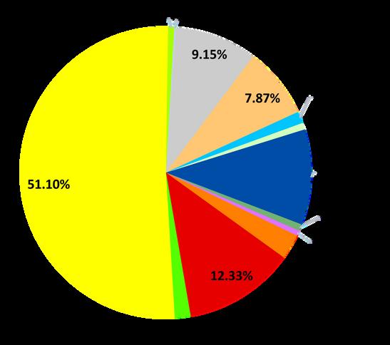
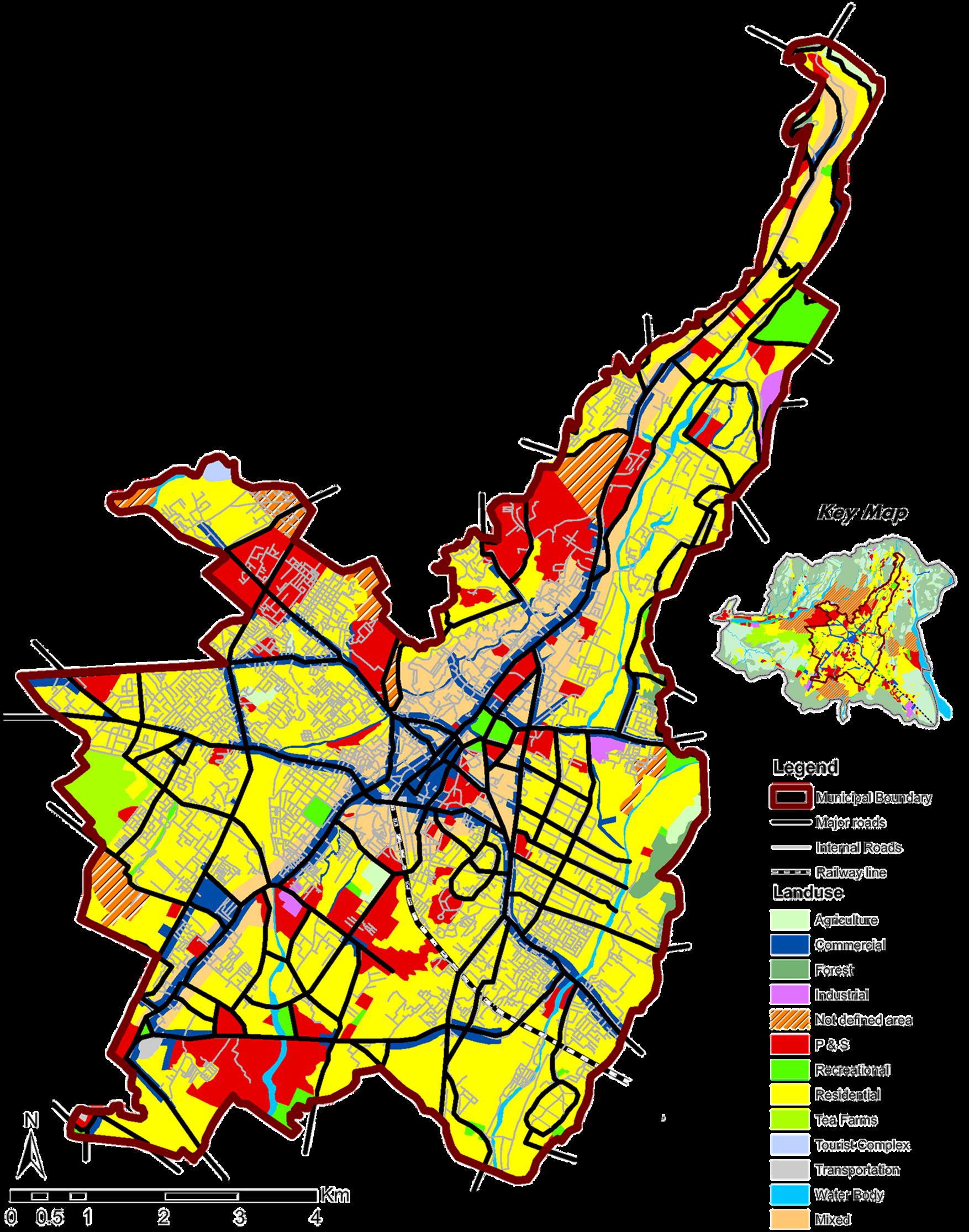
Land use map of Dehradun M. Corp; U.K.