4 minute read
Zonal Development plan BACKGROUND & CONTEXT


Project Information
Type: Location:
Advertisement
Area: Coordinator:
Project Scope:
Contributions:
Planning Studio- IV
Visakhapatnam, A P
17.56 sq. km.
Ar Snigdha
Coastal Plan
Developed base map and land use map Studied housing guidelines as well as coastal disaster management norms and incorporated them into the proposals
Conducted a primary survey to find out about the physical, and social infrastructure and the transportation pattern and proposed some interventions.
Background
A Zonal Development Plan means a plan for each zones (Division) containing information regarding the provision of social infrastructure, parks, open spaces, circulation system, etc The Zonal Development Plan indicates the actual as well as proposed use zones designated in the ‘land use ’ categories stated in the Master Plan according to which the area in the Zone is to be finally developed Users indicated in the Zonal Development Plan will not give an automatic right to the owners to use their property/land for the designated use
Zonal development planning involves community members working together with the city to identify specific issues affecting their community and produce a plan that provides solutions to meet the specific needs of their local area and support its unique character They focus on planning for the management of future growth as well as offering community service provision Thus, each ZDP intends to identify a broad range of issues that affect the local area and, in consultation with the local community, establishes a vision and objectives for the area, consolidating strategies and actions already identified in city-wide strategic documents
From different landforms, (i.e. Hilly, Coastal and Plain Areas), we opted for Visakhapatnam cause being the coastal site, it delivers all the aspects of different landforms like hilly and flat land, making the site suitable for the study of different landforms Visakhapatnam is a port city, also known for its tourist attraction and industries, attracts a huge audience those have the capacity to expand the city in such a way that it can stand on their expectations
Objectives
To look and provide for the future requirement and present backlog of the Shelters in the zone to provide for basic housing needs
To look for and provide for the basic infrastructure services and basic amenities to the present population of the zone and plan for future population needs as well
To facilitate the movement of people and goods by enhancing the zone ’ s existing infrastructure and wayfinding systems
To preserve and enhance the zone ’ s built environment and public spaces through the skillful application of advanced historic preservation and urban design principles and methods.
Visakhapatnam
Popularly known as “The jewel of the East Coast” It is famous for its oldest shipyard in India and the longest seaport in the country. It has bright aspects for education and economic development activities as it provides numerous opportunities for the development of these sectors and many other sectors like tourism, infrastructure, fishery, agriculture, oil refinery, steel plants, etc. The city is among one of the most populous cities of the state and is among the top 10 cleanest cities in India The geographical conditions of Vishakhapatnam are said to be almost the same as San Francisco and that has helped it in becoming a famous tourist attraction. It is primarily an industrial city, apart from being a port city The city is also famous as the steel city of Andhra Pradesh due to the presence of a large steel plant of Rashtriya Ispat Nigam Limited
Zone-2:
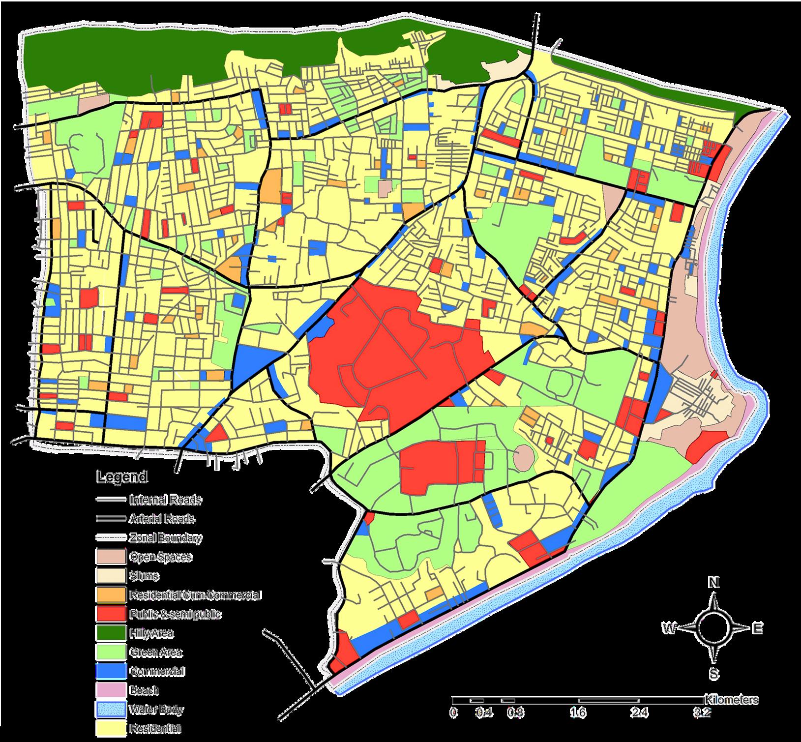
Being the central part of the city, Zone-2 has different land uses like residential, commercial, public & semi-public, etc. The majority of people love to reside in Zone-2 as they have the advantage to access everything easily as compared to different zones. Zone-2 consists of the famous Andhra University as well as VMRDA INS Kursura Submarine Museum, increasing the attraction zone for students and tourists. VMRDA Kailasagiri as a hill station also helps in enhancing the tourist industry of Visakhapatnam.
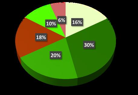
Parks
Urban parks are green spaces set aside for recreation inside towns and cities There is a adequate amenity of designated parks, Playground is a playpark, or play area is a place specifically designed to enable children to play there. It is typically outdoors. There is adequate facility of playground through out Zone 2
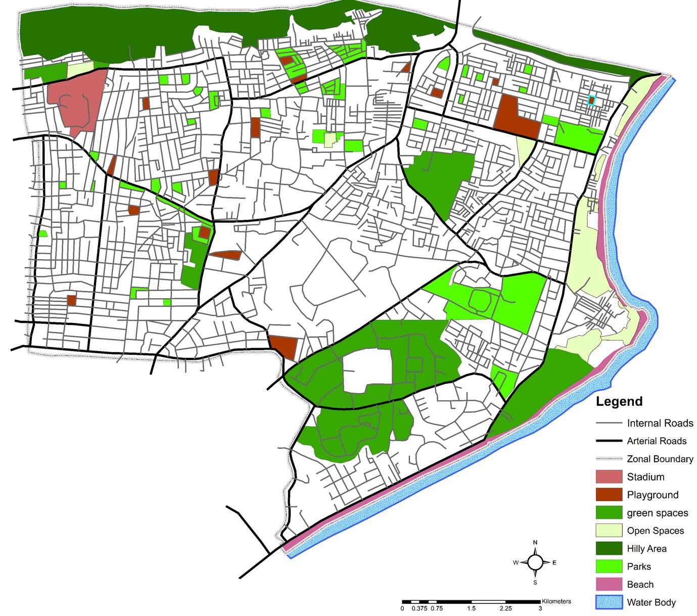
Beach is a sandy area, this area also used for recreational purposes Zone 2 got famous beaches in Vishakhapatnam and most famous is RK beach Beaches in zone 2 are clean and safe for people which adds more value to them
Stadium is a athletic or sports ground with tiers of seats for spectators and in vizag zone 2 there is Port Trust Diamond Jubilee Stadium It is a multi-purpose stadium The stadium has a two-tier architecture and designed in such a way that view of the match in action is not obstructed regardless of the seating location. It is currently used mainly for cricket matches.The stadium was built in 2003and has a capacity of 5,000 seats
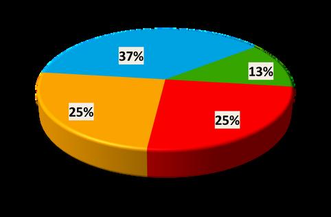
Land use Classification
The majority of land in Zone 2 belongs to residential use which is 43 %
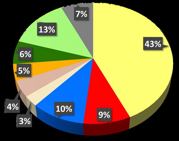
Transportation use is within 7% of the land which is quite lower compared to the Master Plan causing congested roads and traffic problems
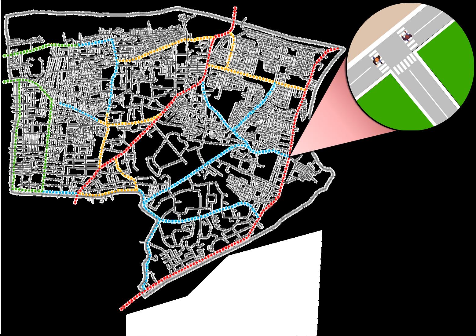
Vizag Zone 2 being a center of the city and along side a famous RK beach attracts a lot traffic movement as well as pedestrian movement. The pedestrian movement is high along side the beach area
Most of the footpaths built in the city were constructed as per the earlier Government Order (GO) issued by the state government to maintain a width of 1 5m The more recent footpaths, totaling 6 km in length, built along the inner ring of the zone have a width of 2m, which is insignificant when viewed as a proportion of the total road network in the city The 3m wide footpaths built along the Beach Road is concentrated only along the 4km stretch and not replicated in other parts of the city
The entire zone has approximately 21km of footpaths , It is observed that 50 per cent of the footpaths in the city are discontinuous, due to various reasons like the presence of electric poles and trees on the footpath, entry to properties along the road, and breaks in footpaths at crossings and on-street parking 20 per cent of the footpaths are mostly encroached by parking and shopkeepers along the road extending their shops to the footpaths. Only 30 per cent of the footpaths are without any encroachments However, even these footpaths are not completely pedestrian-friendly because they are mostly concrete blocks placed as A cover to the sewer lines below They are 180-200mm above the road surface and have occasional gaps between concrete blocks making them uncomfortable to the users Majority of the arterial roads in the city had adequate street lighting for the carriageway, but did not provide separate lighting for the footpaths