City Council of Danville, Virginia adopted this Unified Development Code by Ordinance 2025-12.03 and is effective as of January 1, 2026.
Introduction and How to Use This Code
This Article provides introductory provisions and information needed to navigate this Code.
§ 41.1.A. Title and Effective Date.
1. Chapter 41 is the Danville Unified Development Code (UDC) and will be referred to in this chapter as the “Code.”
2. This Code is effective as of January 1, 2026.
§ 41.1.B. Purpose and Intent.
1. This Code carries out and advances the goals and objectives of § 15.2-2200 of the Code of Virginia, 1950, as amended, and is the implementation of PLANDanville: A Comprehensive Plan for a Unified Future (herein after referred to as “PLANDanville”) adopted and effective January 1, 2025.
§ 41.1.C. Legal Provisions.
1. Authority and applicability.
a. This Code is adopted pursuant to the powers granted and limitations imposed by § 15.2-2280 et seq., of the Code of Virginia, 1950, as amended. It applies to all property within the corporate limits of the City, excepting any areas that are under the sovereign control of the United States of America, the Commonwealth of Virginia, or the County of Pittsylvania, Virginia.
2. Compliance required.
a. No building or structure hereafter shall be erected, and no existing building or structure shall be moved, altered, added to, or enlarged, nor shall any land or structure be used or arranged for any purpose or manner other than those permitted in this Code. All buildings or structures shall be located on an approved parcel of record, each containing only one (1) principal building unless otherwise permitted in this Code.
3. Pending applications.
a. For applications accepted as complete before the effective date of this Code, but still pending final approval as of that date:
1. The application will be processed according to regulations in effect when the application was accepted. The subsequent development, although permitted, will be deemed “nonconforming” if the development does not comply with any provisions this Code, and all applications for the same parcel made after the effective date of this Code shall be subject to the provisions of Article 6 Nonconformities; or
2. The applicant may choose to withdraw the pending application and submit a new application that complies with the procedures and standards of this Code, with no additional application fees owed by the applicant.
4. Prior approvals.
a. Nothing in this Code shall be deemed to require any change to the plans, plats, parcels, or buildings approved prior to the effective date of this Code. Any development that does not comply with the provisions this Code shall be deemed “nonconforming”, and all applications for the same parcel made after the effective date of this Code shall be subject to the provisions of Article 6 Nonconformities.
Severability.
a. Should any article, section, or any provision of this Code be decided by the courts to be unconstitutional or invalid, such decision shall not affect the validity of the Code as a whole, or any part thereof other than the part so held to be unconstitutional or invalid.
6. Conflicting provisions.
a. Jurisdictional requirements.
1. Whenever any provision of this Code imposes a greater requirement or a higher standard than is required in any State or Federal statute or any other City Ordinance or regulation, the provision of this Code shall govern.
2. Whenever any provision of any State or Federal statute or other City ordinance or regulation imposes a greater requirement or a higher standard than is required by this Code, the provision of such State or Federal statute or other City ordinance or regulation shall govern.
3. The text of this Code shall be applied to any parcel covered by a previous grant of zoning with proffered conditions except where the imposition of the requirements of this Code would be in conflict with a specified proffered condition which would supersede the requirements of this Code.
b. Private agreements.
1. It is not the intent of this Code to interfere with, abrogate, or annul any easements, covenants, or agreements between private parties. However, where this Code imposes a greater requirement or higher standards than an easement, covenant, or agreement between private parties, the provisions of this Code shall govern.
7. Annexation.
a. Any territory hereafter annexed into the City of Danville shall be considered classified under the Transitional Residential (TR) Zone, unless otherwise designated by ordinance or annexation agreement.
§ 41.1.D. How to Use This Code.
1. Interpreting words.
a. Unless the obvious construction of a word indicates otherwise:
1. Words used in the present tense can include the future tense.
2. Words used in the masculine gender include the feminine gender and neuter.
3. Words in the plural can include the singular.
b. The word “shall,” “will,” and “must” are mandatory.
c. The word “may” is permissive.
2. How to interpret the Official Zoning Map.
a. Zone and district boundaries are displayed on the Official Zoning Map.
b. If the zone and district boundaries shown on the Official Zoning Map are unclear, the following rules will apply.
1. Zone and district boundaries cannot divide a parcel.
A. Each parcel in the City will have one (1) base zone or district classification, however, a parcel may have multiple overlay zone classifications.
B. If the Official Zoning Map classifies a parcel within more than one (1) base zone or district, the zone or district applying to the largest percentage of the parcel will apply.
2. Where a zone or district boundary appears to follow a roadway, alley, railroad, or highway, such boundary will be the same as centerline of that roadway, alley, railroad, or highway.
3. Where a zone or district boundary appears to follow parcel lines, such boundary will be the same as those parcel lines.
4. Where a zone or district boundary appears to follow the City boundaries, such boundary will be the same as the City boundary.
5. Where a zone or district boundary appears to follow a river, stream, marsh, or other body of water, such boundary will be the same as the centerline of the river, stream, marsh, or other body of water.
6. The Flood Hazard Maps, as amended, prepared by the Federal Emergency Management Administration (FEMA) determine the boundaries of the Floodplain Overlay (FPO) and are considered part of the Official Zoning Map.
7. The Architectural Review Overlay Map and this Code determine the boundaries of the Architectural Review Overlay (ARO) and is considered part of the Official Zoning Map.
8. No zone or district may be applied to less than one (1) parcel.
9. If a parcel is not shown on the Official Zoning Map as being located within a zone or district, such parcel will be considered within the TR Zone until the property is rezoned according to § 41.8.S. Zoning Amendment.
3. How to apply dimensional standards.
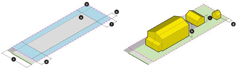
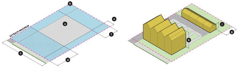
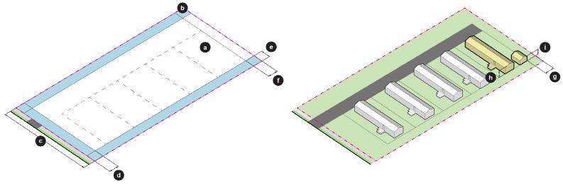
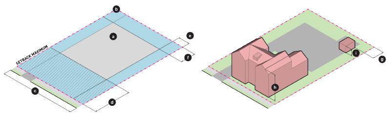
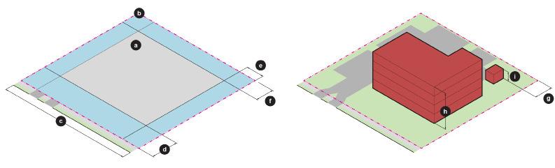
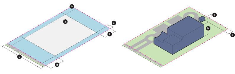
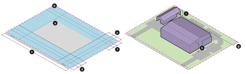
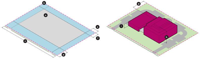
a. To determine the dimensional standards for a parcel, review the dimensional standards table provided for each zone and district.
1. The column titled “Modification Method” shall establish the development application that must be approved for a modifcation to the requirement established in the applicable dimensional standards table.
b. No sign, fence, wall, structure, or use will be established, altered, or enlarged if the parcel and structure do not meet all of the dimensional standards for the applicable zone or district in which the structure is or is planned to be located.
4. How to apply use regulations.
a. To determine which uses are allowed on a parcel, see Table 3.A-2: Comprehensive Use Permissions Table. Within the table, find the intersection of the desired use and applicable zone or district.
1. Uses which are permitted by-right are indicated with a “P” if they are principal uses and an “AP” if they are accessory uses.
2. Uses which are permitted by approval of a Special Use Permit are indicated with an “SUP” if they are principal uses and an “ASUP” if they are accessory uses.
A. The approval of a Special Use Permit applies only to the use for which it is approved.
B. Changing to a different use requiring approval of a Special Use Permit will require a new Special Use Permit.
3. Principal uses which are permitted by approval of a Special Exception Permit are indicated with an “SEP.”
A. The approval of a Special Exception Permit applies only to the use for which it is approved.
B. Changing to a different use requiring approval of a Special Exception Permit will require a new Special Exception Permit.
4. In each zone and district, any use not permitted by-right, by Special Use Permit approval, or by Special Exception Permit approval will be prohibited in that zone or district.
b. In some cases, Table 3.A-2: Comprehensive Use Permissions Table may identify a “use standard” applying to a specific use. In such situations, the use must meet the standards applicable to that use in § 41.3.B. Use Standards.
1. If a use permitted by-right cannot comply with the applicable use standards, it may be permitted through the approval of a Special Use Permit.
2. If a use permitted by approval of a Special Use Permit has applicable use standards, demonstration of the ability to comply with such use standards will be a condition of the Special Use Permit approval.
A. The approval of a Special Use Permit does not automatically waive the applicable use standards.
B. A Special Use Permit may only waive an applicable use standard if such use standard specifies the ability of a Special Use Permit to waive such standard.
C. In the approval of a Special Use Permit, the approving authority may attach additional use standards that must be met.
5. How to apply general standards.
a. In addition to the dimensional standards and use regulations, this Code requires compliance with standards relating to parking, landscaping, open space, lighting, signs, and more. These standards can be located in Article 4 Generally Applicable Standards.
6. How to apply for development applications.
a. Information regarding the applicability of, approval process for, and information required on all development applications shall be found in Article 8 Administration and Procedures.
7. How to measure.
a. Distances.
1. Unless otherwise specified, all distances will be measured horizontally and at right angles to the line in relation to which the distance is specified.
b. Parcel area. The parcel area will be the total area measured in a horizontal plane extending to the perimeter parcel lines.
1. Minimum parcel area excluding physical land constraints. No residential parcels will be created in which more than 25% of the required minimum parcel area is comprised of one (1) or more of the following physical land constraints:
A. Slopes of 30% or greater;
B. Wetlands;
C. 100-year floodplain; and
D. Streams, rivers, or other water features.
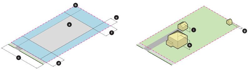
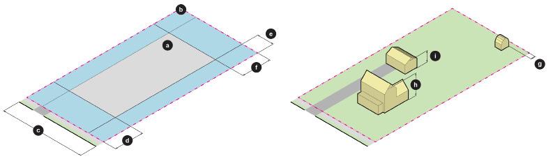
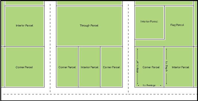
c. Road frontage width. The minimum road frontage width will be the distance between side parcel lines as measured at the front parcel line approved on the Final Subdivision Plat.
1. Parcels fronting on curved streets. For parcels fronting on curved streets, the minimum road frontage width will be measured along a straight line drawn between the minimum front yard setback on each side parcel line. In no circumstance may a parcel have a front parcel line with less than 25 feet in common with a public street right-of-way line.
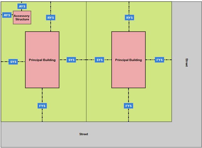
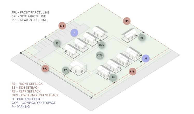
d. Setbacks.
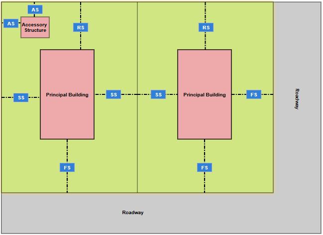
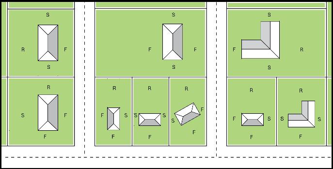
1. Front setback.
A. The front setback will be the distance between the front parcel line and the nearest part of the principal building or use. The front setback must extend across the full property width.
2. Side setback.
A. The side setback will be the distance between a side parcel line and the nearest part of the principal building or use. The side setback must extend from the front setback to the rear setback
3. Rear setback.
A. The rear setback will be the distance between the rear parcel line and the nearest part of the principal building or use that extends across the full property width, excluding accessory structures.
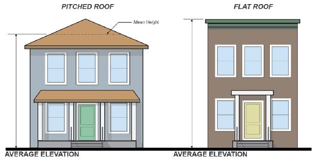
e. Building height. The building height will be measured differently, depending on the type of roof.
1. Flat roofs. The building height shall be the vertical distance between the finished grade at the building line and the highest point of the roof.
A. If any part of the building is less than 10 feet from the front parcel line, the building height will be measured from the finished grade at the front parcel line.
B. Mansard roofs will be considered flat roofs, except that the building height for a building with a mansard roof shall be the vertical distance between the finished grade at the building line and the deck line of the roof.
C. If any part of the building is less than 10 feet from the front parcel line, the building height will be measured from the finished grade at the front parcel line.
2. Pitched roofs. The building height shall be the vertical distance between the finished grade at the building line and the average height between the eaves and the ridge of the roof.
A. If any part of the building is less than 10 feet from the front parcel line, the building height will be measured from the finished grade at the front parcel line.
f. Impervious surface coverage.
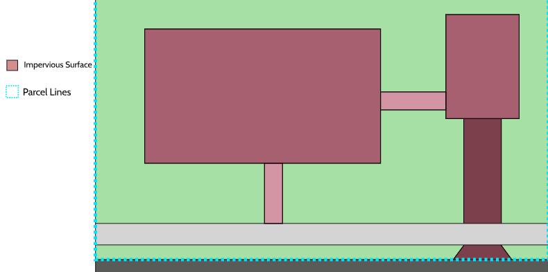
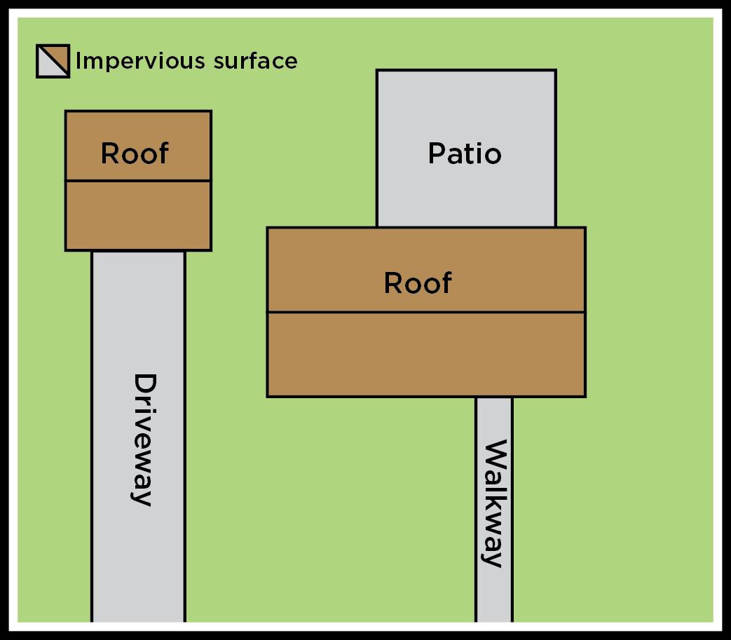
1. The impervious surface coverage will be the percentage of parcel area covered by impervious surfaces. The impervious surface coverage is calculated by dividing the area of a parcel covered by impervious surfaces by the parcel area.
A. See § 41.9.A. Definitions (A to Z). to determine what is considered an impervious surfaces.
g. Open space coverage. Required open space coverage will be the percentage of a parcel intended to provide light and air to the ground surface, and which is designed for either aesthetic or recreational purposes. The open space coverage is calculated by dividing the area of a parcel covered by open space by the parcel area.
1. Open space must, in general, be available for entry and use by the residents or occupants of the development but may include a limited proportion of space so located and treated as to enhance the amenity of the development by providing landscaping features, screening for the benefit of the occupants or those in neighboring areas, or a general appearance of openness.
2. Open space will not include driveways, parking lots, other vehicular surfaces, or areas occupied by a building so located or so small as to have no substantial value for the purpose stated in this provision.
2
Zones and Districts
This Article divides the City into zones and districts and provides standards for development within such areas.
Land Use Policies from PLANDanville.
LU.1: NEIGHBORHOOD CHARACTER
SUPPORT DIFFERENT NEIGHBORHOOD TYPES ACROSS THE CITY, FROM RURAL TO SUBURBAN TO URBAN, INTEGRATING A VARIETY OF HOUSING OPTIONS.
LU.1.1 Preserve Rural Landscapes
Prevent over-development of greenfield and rural areas to preserve their environmental integrity and promote sustainability through cluster development.
LU.1.2 Maintain Community Character
Implement place type recommendations of this chapter through zoning amendments to better integrate context-sensitive design and embrace community character.
LU.2: CENTERS WITH ACCESS TO SERVICES
BUILD UP VITAL SERVICES IN KEY AREAS TO MAKE SURE ALL RESIDENTS CAN EASILY ACCESS THEM.
LU.2.1 Encourage Growth in Existing Developed Areas
Maximize the impact of infrastructure investments and minimize the environmental impacts of urban sprawl by promoting growth and development in already developed areas of the city.
LU.3: CONNECTED CORRIDORS
ALIGN LAND USE AND TRANSPORTATION ENHANCEMENTS TO BETTER CONNECT PEOPLE WITH RESOURCES.
LU.3.1 Concentrate Corridor Development
Encourage the development of community resources along key transportation corridors to provide residents with expanded access to essential amenities.
LU.3.2 Organize Parking and Access
Limit the impacts of parking and access management on the character and flow of corridors.
41.2.A. Establishment of Zones and Districts.
1. The City is geographically divided into 14 zones and districts as well as 3 overlays, as established in the table below. Table 2.A-1: Zone and District Conversion
§ 41.2.B. Conversion of Future Land Use Categories.
1. The new zones and districts have been developed using the Future Land Use section of PLANDanville.
Table 2.B-2: Conversion of Future Land Use Categories
Urban Agriculture (UA)
Threshold Residential (TR)
Urban Residential (UR)
Multi-Unit Residential (MR)
Manufactured Home Park
Residential (MHR)
Community Business (CB)
Highway Business (HB)
Institutional (IS)
Innovation and Manufacturing (IM)
Entertainment and Gaming District (EGD)
River District (RD)
Campus District (C)
Metro Plaza District (MP)
North Main Business District (NMBD)
§ 41.2.C. UA - Urban Agriculture Zone.
1. Purpose and intent.
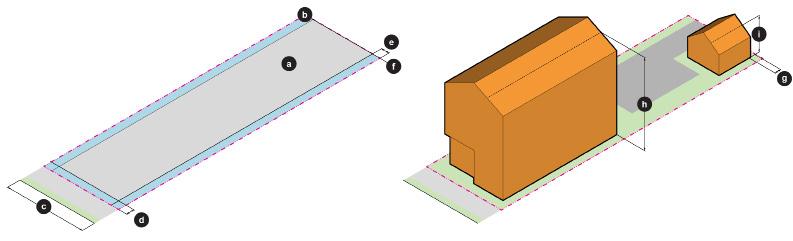
a. The Urban Agriculture (UA) Zone is intended to preserve large rural, agricultural, and natural areas while providing appropriate housing options.
2. Dimensional standards table.
a. Density (max.)
b. Parcel Area (min.)
c. Road Frontage Width (min.)
d. Front Setback (min.)
e.
f. Rear Setback (min.)
g. Accessory Structure Setback (min.)
h. Principal Building Height (max.)
i. Accessory Structure Height (max.)
j. Impervious Surface Coverage (max.)
k. Open Space Coverage (min.)
§ 41.2.D. TR – Transitional Residential Zone.
1. Purpose and intent.
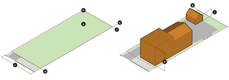
a. The Transitional Residential (TR) Zone is created to preserve small rural, agricultural, and natural areas while providing appropriate housing options.
2. Dimensional standards table.
a. Density (max.)
b. Parcel Area (min.)
c. Road Frontage Width (min.)
d. Front Setback (min.)
e. Side Setback (min.)
f.
g. Accessory Structure
h.
i. Accessory Structure
j. Impervious Surface
k. Open Space Coverage (min.)
§ 41.2.E. UR – Urban Residential Zone.
1. Purpose and intent.
a. The UR Urban Residential (UR) Zone is established to allow the dense development of varying housing types.
2. Dimensional standards table.
a. Density (max.)
b. Parcel Area (min.)
c. Road Frontage Width (min.)
d. Front Setback (min.) 20 ft. or average of front setbacks for parcels abutting the side yards. Special Use Permit
e. Side Setback (min.)
f. Rear Setback (min.) 20 ft.
g. Accessory Structure Setback (min.) 5 ft.
Special Use Permit
Special Use Permit
Special Use Permit
h. Principal Building Height (max.) 35 ft. Variance
i. Accessory Structure Height (max.) 24 ft. Variance
j. Impervious Surface Coverage (max.) 75% Variance
k. Open Space Coverage (min.) NA NA Footnotes.
1 Up to 8 dwelling units per parcel may be permitted through the approval of a Special Use Permit.
2 A Special Use Permit may only modify this provision for a single-unit detached dwelling located on an existing, platted infill parcel. Otherwise, approval of a Variance shall be required to waive this provision.
§ 41.2.F. MR – Multi-Unit Residential Zone.
1. Purpose and intent.
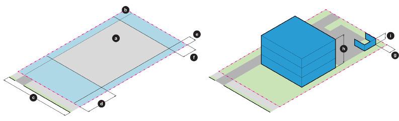
a. The Multi-Unit Residential (MR) Zone is intended provide multi-unit housing while maintaining green space.
2. Dimensional standards table.
a. Density (max.)
8 dwelling units per parcel for townhouse dwellings and 16 dwelling units per parcel for elderly and assisted living, multi-unit dwellings and supportive housing
b. Parcel Area (min.) 16,000 sq. ft.
c. Road Frontage Width (min.)
d. Front Setback (max.)
e. Side Setback (min.)
f.
g. Accessory Structure Setback (min.)
h. Principal Building Height (max.)
i. Accessory Structure Height (max.) 24 ft.
j. Impervious Surface Coverage (max.) 75%
k. Open Space Coverage (min.) 25%1
Footnotes.
Use Permit 2
Permit
Use Permit
Use Permit
Use Permit
1 50% of the minimum required open space (12.5% of the site) must be used as recreation or community space.
2 A Special Use Permit shall be required to increase the maximum density of elderely and assisted living, multi-unit dwellings, and supportive housing uses.
3. Additional standards.
a. Additional Setback and Parcel Requirements.
1. Where adjacent properties are in a zone or district other than the MR Zone, all buildings within the MR-zoned parcel must be set back at least 30 feet from the common district parcel lines, or as otherwise provided by § 41.4.C. Landscaping, Screening, and Buffering.
b. Traffic Impact Assessment. A Traffic Impact Assessment may be required for any MR Zone application, as determined by the Division Director of Planning/ Zoning Administrator.
§ 41.2.G. MHPR - Manufactured Home Park Residential Zone
1. Purpose and intent.
a. The Manufactured Home Park Residential (MHPR) Zone is established to provide locations for existing manufactured home parks and associated amenities.
2. Dimensional standards table.
a. Density (max.) 6,000 sq. ft. of parcel area. 1 Variance
b. Parcel Area (min.) 25 acres. 2 Special Use Permit
c. Road Frontage Width (min.) 150 ft. 2 Variance
d. Front Setback (min.)
e. Side Setback (min.)
f. Rear Setback (min.)
15 ft. from each unit to a public and private roadway. 1 Variance
15 ft. from each unit to another unit and parcel line. 1 Variance
15 ft. from each unit to another unit and parcel line.1 Variance
g. Accessory Structure Setback (min.) 5 ft. 1 Variance
h. Principal Building Height (max.) 18 ft. 1 Variance
i. Accessory Structure Height (max.) 18 ft. 1 Variance
j. Impervious Surface Coverage (max.) 50% 1 Variance
k. Open Space Coverage (min.) 25% 2 3 Variance Footnotes.
1 These standards shall apply to individual manufactured home dwelling lots as well as the manufactured home dwelling parcel.
2 These standards shall not apply to individual manufactured home dwelling lots.
3 50% of the minimum required open space (12.5% of the parcel) must be used as recreation or community space.
3. Additional standards.
a. A Traffic Impact Assessment may be required for any MHPR Zone application, as determined by the Division Director of Planning/ Zoning Administrator.
b. Existing nonconforming manufactured homes situated on platted parcels, though recognized in their nonconforming status on the date of adoption of this Code, will be subject to the provisions of the MHPR Zone if altered in any manner.
§ 41.2.H. CB – Community Business Zone.
1. Purpose and intent.
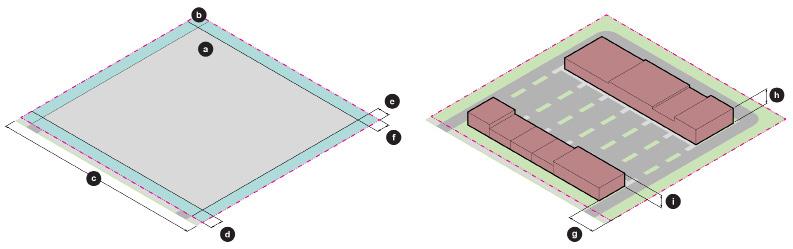
a. The Community Business (CB) Zone is designed to create small, walkable areas that combine commercial and residential spaces that seamlessly blend into surrounding neighborhoods.
2. Dimensional standards.
a. Density (max.)
b. Parcel Area (min.)
c. Road Frontage Width (min.)
d. Front Setback (max.)
e. Side Setback (min.)
but 20 ft. if abutting a residential zone. Special Use Permit
f. Rear Setback (min.) 15 ft. but 20 ft. if abutting a residential zone. Special Use Permit
g. Accessory Structure Setback (min.) 15 ft.
h. Principal Building Height (max.) 35
i. Accessory Structure Height (max.)
j. Impervious Surface Coverage (max.)
k. Open Space Coverage (min.)
3. Additional standards.
a. Curb cuts.
1. The approval of the Division Director of Planning/ Zoning Administrator will be required prior to the construction of a new curb cut on a public roadway.
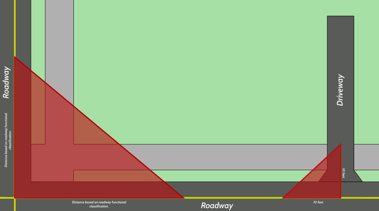
2. On a corner parcel, no curb cut will be located closer than 50 feet to the rightof-way line extended from the intersecting street.
3. All curb cuts on the same parcel must be at least 100 feet apart and no curb cut will be located closer than 15 feet to a side or rear parcel line, unless a common curb cut serves adjacent uses.
4. All curb cuts on the same parcel must be at least 100 feet apart. Separate curb cuts serving adjacent parcels must be at least 50 feet apart, unless a common curb cut serves two (2) parcels.
5. No parcel will have more than one (1) curb cut on any single right-of-way.
A. This requirement may be modified through the approval of a Special Use Permit.
§ 41.2.I. HB – Highway Business Zone.
1. Purpose and intent.
a. The Highway Business (HB) Zone is established to support retail, service, and business development along major roadways.
2. Dimensional standards table.
a. Density
b.
c. Road Frontage Width (min.)
d. Front Setback (min.)
d. Front Setback (max.)
e.
f.
g.
h.
i. Accessory Structure
j. Impervious Surface Coverage (max.)
k. Open Space Coverage (min.)
Footnotes.
1 Any merchandise displayed in the front yard must be set back at least 20 ft. from the parcel line.
2 If no access to a collector, minor arterial, or principal arterial roadway is provided, the front setback may be reduced to 20 ft.
3 The minimum side setback will be increased to 30 feet if the parcel abuts a residential zone.
4 The minimum rear setback will be increased to 30 feet if the parcel abuts a residential zone.
3. Additional standards.
a. Parcels fronting the Dan River.
1. Any use with parcel frontage on the Dan River must receive Special Use Permit approval.
b. Curbs cuts.
1. On a corner parcel, no curb cut will be located closer than 75 feet to the right-of-way line extended from the intersecting street.
2. No curb cut will be located closer than 20 feet to a side or rear parcel line, unless a common curb cut serves adjacent uses.
3. Other than a common curb cut serving adjacent uses, separate curb cuts serving adjacent uses must be at least 60 feet apart.
4. No parcel will have more than two (2) curb cuts on any single right-of-way.
A. This requirement may be modified through the approval of a Special Use Permit.
5. All curb cuts on the same parcel must be at least 100 feet apart.
§ 41.2.J. IS – Institutional Zone.
1. Purpose and intent.
a. The Institutional (IS) Zone is intended to support schools, hospitals, and public facilities while maintaining inviting streetscapes.
2. Dimensional standards table.
a. Density (max.)
b. Parcel Area (min.)
c. Road Frontage
d.
e. Side Setback (min.)
f. Rear Setback (min.)
g. Accessory Structure Setback (min.)
h. Principal Building Height (max.)
i. Accessory Structure Height (max.)
j. Impervious Surface Coverage (max.)
k. Open Space Coverage (min.)
Footnotes.
but 20
if abutting a residential zone.
Use Permit
Use Permit
Permit
1 Existing, conforming residential uses shall be subject to the UR Zone dimensional standards table in § 41.2.E.2.
3. Additional standards.
a. Front yard parking shall only be permitted through the approval of a Special Use Permit.
§ 41.2.K. IM – Innovation and Manufacturing Zone.
1. Purpose and intent.
a. The Innovation and Manufacturing (IM) Zone is created to encourage industrial and economic development.
c.
g.
3. Additional standards.
a. All developments in the IM Zones shall comply with any applicable restrictive covenants.
1. In the IM-R Zone, the restrictive covenants for the River View Industrial Park Expansion, dated
2. Dimensional standards table.
September 1999, shall be applicable.
2. In the IM-C Zone, the restrictive covenants for the Cyber Park, dated September 20, 2004, shall be applicable.
3. In the IM-A Zone, the protective covenants for the Danville Airside Industrial Park, dated September 2011, shall be applicable.
b. In the IM-R, IM-C, and IM-A Zones, no use shall be established which the review committee determines to be incompatible with the overall character and intent of the development of the parcel.
c. In all IM Zones, no use shall be established which is enables noxious or offensive activities which may be or become an annoyance or nuisance to the owner, tenant, or occupant of other parcels within the zone by reasons of unsightliness or the excessive emissions of fumes, glare, vibration, gases, radiation, dust, liquid or solid waste, smoke, or noise.
d. On-street parking. No on-street parking will be allowed in any IM Zone.
e. Parcels fronting and within the AO. Any use with parcel frontage or within the AO must receive Special Use Permit approval prior to the establishment of any use.
f. Environmental impact statement. An environmental impact statement may be required for any use. All uses must conform to City, state, and federal environmental performance standards and design criteria as related to air pollution; fire and explosion hazards; radiation hazards; electromagnetic radiation and interference hazards; liquid, gas and solid wastes hazards; noise standards; vibration standards; illumination and glare; water quality; and others standards as may be requested by the Planning Commission.
g. Curbs cuts.
1. On a corner parcel, no curb cut will be located closer than 60 feet to the curb line extended from the intersecting public street.
2. No curb cut will be located closer than 20 feet to a side or rear parcel line, unless a common curb cut serves adjacent uses.
3. Other than a common curb cut serving adjacent uses, separate curb cuts serving adjacent uses must be at least 60 feet apart.
4. No parcel will have more than two (2) curb cuts on any single right-of-way.
A. This requirement may be modified through the approval of a Special Use Permit.
5. All curb cuts on the same parcel must be at 100 feet apart.
h. Parcels adjacent to residential districts. Where a parcel is adjacent to a residential zone, all buildings must be set back at least 75 feet from common parcel lines.
1. A landscape buffer yard must also be provided. Landscape materials and placement will be subject to Site Plan approval.
2. Fencing may be required. Fence material and heights will be subject to Site Plan approval.
i. Parcels containing multiple buildings. Where more than one (1) non-accessory building is permitted
on the same parcel, the buildings must be separated by at least 30 feet.
j. Evaluation of performance standards by City Council. In the evaluation of performance standards for any use in the IM Zone, City Council, at its sole discretion, may impose other conditions and additional restrictions to that use for the purposes of ensuring the mitigation of impacts and promote the health, safety, and general welfare of the citizens of Danville.
1. Purpose and intent.
a. The Entertainment and Gaming District (EDG) is established to serve broader economic, cultural, and community activities within the City.
2. Dimensional standards table.
a. District
b. Parcel Area (min.)
c. Road Frontage
d.
e.
g.
h. Principal Building Height (max.)
i. Accessory Structure Height (max.)
j. Impervious Surface Coverage (max.)
k. Open Space Coverage (min.)
Footnotes.
1 Buildings taller than 100 ft. must provide a 50 ft. setback. Buildings taller than 200 ft. must provide a 100 ft. setback.
3. Additional standards.
a. Building exteriors. All building exteriors must be clad in durable materials. Vinyl siding/cladding is prohibited exterior building material.
b. Curb cuts.
1. No curb cut will be located within 200 feet of another curb cut.
2. On a corner parcel, no curb cut will be closer than 300 feet of the right-of-way extended from the nearest intersecting street.
§ 41.2.M. RD – River District.
1. Purpose and intent.
a. The River District (RD) is intended to preserve the historic and walkable character of the downtown areas of Danville while promoting harmonious development.
2. Dimensional standards table.
a. Density (max.)
b. Parcel Area (min.)
c. Road Frontage Width (min.)
d. Front Setback (max.)
e. Side Setback (max.)
f. Rear Setback (min.)
g. Accessory Structure Setback (min.)
h. Principal Building Height (max.)
i. Accessory Structure Height (max.)
j. Impervious Surface Coverage (max.)
k. Open Space Coverage (min.)
3. Additional standards.
a. Design guidelines.
1. Visit the City's website to view the Architectural Review Design Guidelines.
b. Curb cuts.
Use Permit
1. The approval of the Division Director of Planning/ Zoning Administrator will be required prior to the construction of a new curb cut on a public roadway.
§ 41.2.N. C – Campus District.
1. Purpose and intent.
a. The Campus (C) District is created to support educational institutions by allowing for a dense mix of academic, residential, and community spaces.
2. Dimensional standards table.
a.
c.
d.
e.
f.
g. Accessory Structure Setback (min.)
h. Principal Building Height (max.)
i. Accessory Structure Height (max.)
j. Impervious Surface Coverage (max.)
k. Open Space Coverage (min.)
Use Permit
Special Use Permit
Use Permit
§ 41.2.O. MP – Metro Plaza District
1. Purpose and intent.
a. The Metro Plaza (MP) District is intended to transform transit-focused commercial areas that were once designed for cars into pedestrian-friendly, mixed-use developments.
2. Dimensional standards table.
a. Density (max.)
b. Parcel Area (min.)
c. Road Frontage Width (min.)
d. Front Setback (min.) 0 ft. but 30 ft. at the exterior boundary of the district. Variance
f. Side Setback (min.) 0 ft. but 30 ft. at the exterior boundary of the district. Variance
g. Rear Setback (min.) 0 ft. but 30 ft. at the exterior boundary of the district. Variance
h. Accessory Structure Setback (min.) 0 ft. but 30 ft. at the exterior boundary of the district. Variance
i. Principal Building Height (max.) 50 ft. Special Use Permit
j. Accessory Structure Height (max.) 24 ft. Variance
k. Impervious Surface Coverage (max.) 80% Variance
l. Open Space Coverage (min.)
3. Additional standards.
a. Curb cuts.
1. On a corner parcel, no curb cut will be located closer than 75 feet to the right-of-way line extended from the intersecting street.
2. No curb cut will be located closer than 20 feet to a side or rear parcel line, unless a common curb cut serves adjacent uses
3. Other than a common curb cut serving adjacent uses, separate curb cuts serving adjacent uses must be at least 60 feet apart.
4. No parcel will have more than two (2) curb cuts on any single right-of-way unless a signaled intersections provides access to the curb cut.
5. All curb cuts on the same parcel must be at least 100 feet apart.
§ 41.2.P. NMBD – North Main Business District.
1. Purpose and intent.
a. The North Main Business District (NMBD) is created to encourage economic growth through strategic redevelopment and to promote pedestrian-oriented, mixed-use developments.
2. Dimensional standards table.
h.
i.
3. Additional standards.
a. Design Guidelines.
1. Visit the City’s website to review the Architectural Review Design Guidelines.
b. Curb cuts.
1. No parcel will have more than two (2) curb cuts on any single right-of-way.
2. All curb cuts on the same parcel must be at least 100 feet apart. On a corner parcel, no curb cut will be located closer than 75 feet to the right-of-way line extended from the intersecting street.
41.2.Q. ARO – Architectural Review Overlay.
1. Purpose and Intent.
a. The Architectural Review Overlay (ARO) promotes Danville’s unique character and encourages the conservation and restoration of the City’s historic resources and properties. The ARO is designed to protect designated landmarks and other historic features. The overlay prevents the destruction, damage, or defacement of these sites and their surroundings. The overlay also ensures that any new development or land use is compatible with the existing historic architecture.
b. The ARO is established in accord with § 15.2-2306 of the Code of Virginia, as amended, to maintain, preserve, protect, and enhance the architectural excellence, cultural significance, economic vitality, tourist appeal, visual quality, and historic importance of the City. The purpose of this overlay is to provide for protection against destruction or encroachment upon historic areas, buildings, monuments or other features, buildings, and structures of recognized architectural significance which contribute or will contribute to the cultural, social, economic, political, artistic, or architectural integrity of the City of Danville and the Commonwealth of Virginia.
2. Applicability.
a. The regulations set forth in this section shall apply to all properties within the boundaries of the ARO as established on the City’s Official Zoning Map.
b. To enable the district to operate in harmony with the plan for land use and population density embodied in these regulations, the ARO has been created as a special overlay district to be superimposed on underlying zones and districts contained in these regulations and is to be so designated by a special symbol for its boundaries on the Zoning District Map.
c. The ARO boundaries shall be delineated and mapped as an overlay district on the City’s Official Zoning Map as adopted by City Council with amendments thereto as may be adopted.
3. District administration.
a. Certificate of Appropriateness required. No zoning, site plan, subdivision plat, or building permit shall be issued for the erection, reconstruction, exterior alteration, restoration, rehabilitation, razing, relocation, or demolition of any building, structure, sign, fence, wall, light fixture, accessory building, pavement, grading, site improvement, significant landscaping feature, or other appurtenant element in an ARO unless and until such building or site element has been approved by the Architectural Review Board (ARB) through the issuance of a Certificate of Appropriateness as set forth in § 41.8.F. Certificate of Appropriateness.
b. Establishment of design guidelines. Developments within the ARO shall refer to the Architectural Review Design Guidelines.
c. Provisions for demolition and razing. The owner of an object, building, or structure within the ARO, shall, as a matter of right, be entitled to raze or demolish such object, building, or structure provided that:
1. The owner has applied to the ARB for such right.
2. The owner has for the period of time set forth in Table 2.Q-1: Offer-to-Demolition Timeline and at a price reasonably related to its fair market value, made a bona fide offer to sell such site, object, building, or structure and its associated land to whomever gives reasonable assurance
that it is willing to preserve and restore the landmark, building, or structure and its associated land.
3. That no bona fide contract, binding upon all parties thereto, shall have been executed for the sale of any such landmark, building, or structure and its associated land, prior to the expiration of the applicable time period set forth in Table 2.Q-1: Offer-to-Demolition Timeline.
A. Any appeal which may be taken to court from the decision of the governing body, whether instituted by the owner or by any other proper party, notwithstanding the provisions of § 41.8.W. Administrative Appeals. relating to a stay of the decision appealed from, shall not affect the right of the owner to make the bona fide offer to sell referred to above.
4. The owner shall not offer to sell the property for at least one year after a final decision by the governing body, but thereafter the owner may renew their request to the governing body to approve the razing or demolition of the historic landmark, building, or structure.
Table 2.Q-1: Offer-to-Demolition Timeline
5. During the timeframe for the offer to sell, the ARB may take steps as deemed necessary to preserve, acquire, or relocate the buildings, structures, or appurtenant elements in accord with the purposes of ARO, including, but not limited to, coordination with public agencies, civic groups, and citizens.
4. Additions to the ARO.
a. City Council may adopt an ordinance setting forth the historic landmarks within the City (as established by the Virginia Board of Historic Resources), and any other property, buildings, or structures within the City having an important historic, architectural, or cultural interest, and any historic areas within the City as defined by § 15.2-2201 of the Code of Virginia, and areas of unique architectural value located within designated conservation, rehabilitation, or redevelopment districts, amending the existing Unified Development Code and delineating one or more historic districts, adjacent to such landmarks, buildings, and structures, or encompassing such areas, or encompassing parcels of land continuous to arterial streets or highways found by City Council to be significant routes of tourism access to designated historic landmarks, buildings, structures, or districts within the City or the adjacent jurisdictions.
b. City Council may also amend the existing Unified Development Code by delineating one or more historic districts adjacent to such landmarks, buildings, and structures or encompassing such historic areas, provided that such amendment of the Unified Development Code and the establishment of such zone or district shall be in accordance with the provisions of the Code of Virginia and the provisions of the City Code relative to amendments to this Code.
5. Additional standards.
a. Uses in the ARO. All uses shall be governed pursuant to the underlying zone or district regulations of the zone or district in which the ARO is located.
b. Relation to other applicable laws. Nothing in this section shall be construed to prevent the application of the building code or other laws and other ordinances of the City of Danville which are applicable thereto, provided that provisions of this Code which may be in conflict with this section shall be deemed to be superseded by this section.
c. Parking and loading. Parking and loading provisions shall be in accordance with the provision of this Code unless otherwise restricted by the conditions of the ARB approval or waived by the Division Director of Planning/ Zoning Administrator.
d. Admission fees. The normal maintenance of a historic area or building or the charging of admission fees for visitors, or the visitor tours, centers, or services within the ARO shall not be considered as a commercial use.
§ 41.2.R. AO – Airport Overlay.
1. Purpose and intent.
a. The purpose of the Airport Overlay (AO) is to regulate and restrict land development and the use of property within the vicinity of Danville Regional Airport (the “Airport.”).
1. It is hereby declared that land development – which constitutes an airport hazard – endangers the lives and property of the users of the airport and of the occupants of land in its vicinity.
2. It is also hereby declared that airport hazards in effect reduce the size of the area available for landing, taking-off, and maneuvering of aircraft thus tending to destroy or impair the utility of and public investment in Danville Regional Airport.
3. Accordingly, it is declared necessary in the interest of the public health, safety, and general welfare of the citizens of Danville that the prevention of hazards shall be accomplished by the application and enforcement of special regulations relative to hazards referred to in this section.
b. All regulations set forth in this section shall apply in addition to other regulations set forth elsewhere in this Code.
2. Applicability.
a. The regulations set forth in this section shall apply to all properties within the boundaries of the AO as established on the City’s Official Zoning Map.
3. General regulations.
a. Interference prohibited. Interference with air communication or navigational equipment or operations. No use may cause or intend to cause any of the following:
1. Creates electrical interference with radio communications between aircraft and the Airport;
2. Makes it difficult for flyers to distinguish between the Airport’s lights and other lights;
3. Results in glare in the eyes of pilots using the Airport;
4. Emits smoke which impairs visibility of the Airport; or
5. Otherwise endangers the landing, take-off, or maneuvering of aircraft.
b. Height limitations.
1. No structure, building, tower, antenna, smokestack, chimney, overhead transmission line, or any other object shall be erected, constructed, altered, or enlarged in such a manner as to create a hazard or obstruction in the AO.
c. Additional review of applications.
1. All applications for permits, Zoning Amendments, Conditional Zonings, Variances, and Special Use Permits shall be reviewed by the Division Director of Planning/ Zoning Administrator to ensure compliance with this section and with the applicable regulations enforced by the Federal Aviation Administration (FAA) and the Virginia Department of Aviation (DOAV). Any such application shall be so conditioned as to require the owner of the parcel or structure in question, at their expense, to install, operate, and maintain thereon such markings and lights as may be deemed necessary by City Council or Board of Zoning Appeals, acting with the advice and recommendation of the FAA and the manager of the Airport.
d. Prohibition of construction in Runway Protection Zones.
1. The erection of any building or structure on land located within a Federal or locally designated Runway Protection Zone shall be prohibited.
§ 41.2.S. FPO – Floodplain Overlay.
1. Statutory authorization and purpose.
a. The Floodplain Overlay (FPO) is established to prevent:
1. The loss of life and property;
2. The creation of health and safety hazards;
3. The disruption of commerce and governmental services;
4. The extraordinary and unnecessary expenditure of public funds for flood protection and relief; and
5. The impairment of the tax base.
b. The FPO aims to achieve its goals by:
1. Regulating uses, activities, and development which, alone or in combination with other existing or future uses, activities, and development, will cause unacceptable increases in flood heights, velocities, and frequencies;
2. Restricting or prohibiting certain uses, activities, and development from locating within areas subject to flooding;
3. Requiring all those uses, activities, and developments that do occur in flood-prone districts to be protected and/or floodproofed against flooding and flood damage; and
4. Protecting individuals from buying land and structures which are unsuited for intended purposes because of flood hazards.
2. Applicability.
a. The regulations set forth in this section shall apply to all properties within the boundaries of the FPO as established on the City’s Official Zoning Map.
b. The regulations set forth in this section apply to all privately and publicly owned lands within the jurisdiction of the City of Danville and identified as being flood prone.
3. Compliance and liability.
a. No land shall hereafter be developed, and no structure shall be located, relocated, constructed, reconstructed, enlarged, or structurally altered except in full compliance with the terms and provisions of this section and any other applicable ordinances and regulations which apply to uses within the jurisdiction of this Code.
b. The degree of flood protection sought by the provisions of this Code is considered reasonable for regulatory purposes and is based on acceptable engineering methods of study but does not imply total flood protection. Larger floods may occur on rare occasions. Flood heights may be increased by man-made or natural causes, such as ice jams and bridge openings restricted by debris. This Code does not imply that districts outside the FPO or land uses permitted within such district will be free from flooding or flood damages.
c. Records of actions associated with administering this Code shall be kept on file and maintained by the Division Director of Planning/ Zoning Administrator.
d. This section shall not create liability on the part of the City or any officer or employee thereof for any flood damages that result from reliance on this Code, or any administrative decision lawfully made there under.
4. Relationship to other ordinances.
a. This section supersedes any ordinance currently in effect in flood-prone areas. Any ordinance, however, shall remain in full force and effect to the extent that its provisions are more restrictive.
5. Severability.
a. If any section, subsection, paragraph, sentence, clause, or phrase of this section shall be declared invalid for any reason whatever, such decision shall not affect the remaining portions of this section. The remaining portions shall remain in full force and effect; and for this purpose, the provisions of this ordinance are hereby declared to be severable.
6. Establishment of floodplain districts.
a. Description of districts.
1. Basis of district. The FPO is broken into various floodplain districts. The basis for the delineation of these floodplain districts shall be the Flood Insurance Rate Maps (FIRM) for the City of Danville prepared by the Federal Emergency Management Agency (FEMA), Federal Insurance and Mitigation Administration (FIMA), dated September 29, 2010, and any subsequent revisions or amendments thereto. The boundaries of the special flood hazard areas and floodplain district are established as shown on the FIRM, which is declared to be a part of this Code, and which shall be kept on file at the City of Danville offices.
A. The Floodway District shall be any area within the Floodway Boundary as delineated on
1. For the purposes of this Code, areas within the Floodway Boundary must be capable of carrying the waters of a 100-year flood without increasing the water surface elevation of that flood more than one foot at any point.
B. The Special Floodplain District shall be those areas identified as Zone AE on the FIRM for which 100-year flood elevations have been provided.
C. The Approximated Floodplain District shall be those areas identified as Zone A or Zone A99 on the FIRM.
1. In these zones, no detailed flood profiles or elevations are provided, but the 100-year floodplain boundary has been approximated.
D. The Shallow Flooding District shall be those areas identified as Zone AO or AH on the FIRM.
Table 2.S-1: Establishment of Floodplain Districts
2. Overlay concept.
A. The districts described above shall be overlays to the existing underlying zones and districts as shown on the Official Zoning Map, and as such, the provisions for the floodplain districts shall serve as a supplement to the underlying zone or district provisions.
B. If there is any conflict between the provisions or requirements of the floodplain districts and those of any underlying zone or district, the more restrictive provisions and/or those pertaining to the floodplain districts shall apply.
C. In the event that any provision concerning a floodplain district is declared inapplicable as a result of any legislative or administrative actions or judicial decision, the basic underlying provisions shall remain applicable.
b. District boundary changes.
1. The delineation of any of the floodplain districts may be revised by the City of Danville where natural or man-made changes have occurred and/or where more detailed studies have been conducted or undertaken by the U.S. Army Corps of Engineers or other qualified agency, or on individual documents the need for such change. However, prior to any such change, approval must be obtained from the Federal Insurance and Mitigation Administration.
c. Interpretation of district boundaries.
1. Initial interpretations of the boundaries of the floodplain districts shall be made by the Division Director of Planning/ Zoning Administrator. Should a dispute arise concerning the boundaries
of any of the floodplain districts, the decision of the Division Director of Planning/ Zoning Administrator may be appealed to the Board of Zoning Appeals in accord with § 41.8.W. Administrative Appeals.
d. Submitting technical data.
1. A community’s base flood elevations may increase or decrease resulting from physical changes affecting flooding conditions. As soon as practicable, but not later than six months after the date such information becomes available, a community shall notify the Federal Insurance and Mitigation Administration of the changes by submitting technical or scientific data. Such a submission is necessary so that upon confirmation of those physical changes affecting flooding conditions, risk premium rates, and floodplain management requirements will be based upon current data.
7. General regulations.
a. Permit and application requirements.
1. Zoning Clearance required. All uses, activities, and development occurring within any floodplain district, including the placement of manufactured homes, shall be undertaken in compliance with this Code and upon the issuance of a Zoning Clearance.
A. Prior to the issuance of a Zoning Clearance, the Division Director of Planning/ Zoning Administrator shall require all applications to demonstrate compliance with all applicable local, state, and federal laws and shall review all sites to assure they are reasonably safe from flooding.
B. Under no circumstances shall any use, activity, or development adversely affect the capacity of the channels or floodways of any watercourse, drainage ditch, or other drainage facility or system.
2. Site Plans and Building Permits. All Site Plans and Building Permits submitted for a development within any floodplain district shall incorporate the following information:
A. The elevation of the Base Flood at the site.
B. The elevation of the lowest floor (including basement).
C. For structures to be floodproofed (non-residential only), the elevation to which the structure will be floodproofed.
D. Topographic information showing existing and proposed ground elevations.
b. General standards. All improvements within any floodplain district shall comply with the following.
1. New construction and substantial improvements shall be according to the VA USBC, and anchored to prevent flotation, collapse, or lateral movement of the structure.
2. All dwellings, including manufactured home dwellings, shall be anchored to prevent flotation, collapse, or lateral movement. Methods of anchoring may include, but are not limited to, the use of over-the-top or frame ties to ground anchors.
A. This standard shall be in addition to and consistent with applicable state anchoring requirements for resisting wind forces.
3. New construction and substantial improvements shall be constructed with materials and utility equipment resistant to flood damage.
4. New construction or substantial improvements shall be constructed by methods and practices that minimize flood damage.
5. Electrical, heating, ventilation, plumbing, air conditioning equipment, and other service facilities, including duct work, shall be designed and/or located so as to prevent water from entering or accumulating within the components during conditions of flooding.
6. New and replacement water supply systems shall be designed to minimize or eliminate infiltration of flood waters into the system.
7. New and replacement sanitary sewage systems shall be designed to minimize or eliminate infiltration of flood waters into the systems and discharges from the systems into flood waters.
8. On-site waste disposal systems shall be located and constructed to avoid impairment to them or contamination from them during flooding.
c. Standards for Special Flood Hazard Areas. In addition to the provisions above, in all special flood hazard areas, the additional provisions shall apply:
1. Alteration of channels, watercourses, and streams.
A. Prior to any proposed alteration or relocation of any channels or of any watercourse, stream, or similar feature, within this jurisdiction a permit shall be obtained from the U. S. Corps of Engineers, the Virginia Department of Environmental Quality, and the Virginia Marine Resources Commission (a joint permit application is available from any of these organizations). Furthermore, in riverine areas, notification of the proposal shall be given by the applicant to all affected adjacent jurisdictions, the Department of Conservation and Recreation (Division of Dam Safety and Floodplain Management), and the Federal Insurance and Mitigation Administration.
B. The flood carrying capacity within an altered or relocated portion of any watercourse shall be maintained.
2. Construction standards. In all Special Flood Hazard Areas where base flood elevations have been provided in the Flood Insurance Study or generated according to the standards for the Approximated Floodplain District, the following provisions shall apply:
A. Construction of residential buildings. New construction or substantial improvement of any residential structure (including manufactured home dwellings) shall have the lowest floor, including basement, elevated to or above the base flood elevation to a minimum of one foot freeboard.
B. Construction of non-residential buildings. New construction or substantial improvement of any commercial, industrial, or non-residential building shall have the lowest floor, including basement, elevated to or above the base flood elevation to a minimum of one foot freeboard.
1. Buildings located in a Special Flood Hazard Area may be floodproofed in lieu of being elevated provided that all areas of the building components below the elevation corresponding to the base flood elevation plus one foot are water tight with walls
substantially impermeable to the passage of water, and use structural components having the capability of resisting hydrostatic and hydrodynamic loads and the effect of buoyancy. A registered professional engineer or architect shall certify that the standards of this subsection are satisfied. Such certification, including the specific elevation (in relation to mean sea level) to which such structures are floodproofed, shall be maintained by the Division Director of Planning/ Zoning Administrator.
C. Construction of elevated buildings. Fully enclosed areas, of new construction or substantially improved structures, which are less than one (1) foot above the base flood elevation shall:
1. Not be designed or used for human habitation but shall only be used for the parking of vehicles, building access, or limited storage of maintenance equipment used in connection with the premises.
a. Access to any enclosed area shall be the minimum necessary to allow for the parking of vehicles (garage door) or limited storage of maintenance equipment (standard exterior door), or entry to the living area (stairway or elevator).
2. Be constructed entirely of flood resistant materials below the elevation corresponding to the base flood elevation plus one foot.
3. Within the Special Flood Hazard Area but outside the Regulatory Floodway, measures to automatically equalize hydrostatic flood forces on walls by allowing for the entry and exit of floodwaters may be allowed. To meet this requirement, the openings must either be certified by a professional engineer or architect or meet the following minimum design criteria:
a. Provide a minimum of two (2) openings on different sides of each enclosed area subject to flooding;
b. The total net area of all openings must be at least one square inch for each square foot of enclosed area subject to flooding;
c. If a building has more than one enclosed area, each area must have openings to allow floodwaters to automatically enter and exit;
d. The bottom of all required openings shall be no higher than one foot above the adjacent grade;
e. Openings may be equipped with screens, louvers, or other opening coverings or devices, provided they permit the automatic flow of floodwaters in both directions; and
f. Foundation enclosures made of flexible skirting are not considered enclosures for regulatory purposes, and, therefore, do not require openings. Masonry or wood underpinning, regardless of structural status, is considered an enclosure and requires openings as outlined above.
D. Standards for manufactured home dwellings and recreational vehicles.
1. All manufactured home dwellings placed, or substantially improved, on individual lots or parcels, in expansions to existing manufactured home parks or subdivisions, in a
new manufactured home park or subdivision, or in an existing manufactured home park or subdivision on which a manufactured home dwelling has incurred substantial damage as the result of a flood, must meet the following additional requirements. All manufactured home dwellings and recreational vehicles placed on sites must either:
a. Be on the site for fewer than 180 consecutive days;
b. Be fully licensed and ready for highway use (a recreational vehicle is ready for highway use if it is on its wheels or jacking system, is attached to the site only by quick disconnect type utilities and security devices and has no permanently attached additions); or
c. Meet all the requirements for manufactured home dwellings in § 41.2.S.7.b.
8. Standards for the Floodway District. The following provisions shall apply to all areas within the Floodway District.
a. Activities permitted within the Floodway District.
1. Encroachments, including fill, new construction, substantial improvements, and other developments are prohibited unless certification such as hydrologic and hydraulic analyses (with supporting technical data) is provided demonstrating that encroachments shall not result in any increase in flood levels during occurrence of the base flood. Hydrologic and hydraulic analyses shall be undertaken only by professional engineers or others of demonstrated qualifications, who shall certify that the technical methods used correctly reflect currentlyaccepted technical concepts. Studies, analyses, computations, and similar activities shall be submitted in sufficient detail to allow a thorough review by the Division Director of Planning/ Zoning Administrator. Development activities which increase the water surface elevation of the base flood may be allowed, provided that the applicant and/or developer first applies - with the City of Danville’s endorsement - for a conditional FIRM and floodway revision, and receives the approval of FEMA.
b. All new construction and substantial improvements shall comply with all applicable flood hazard reduction provisions of this section.
c. The placement of manufactured home dwellings is prohibited, except within an existing manufactured home park or subdivision. A replacement manufactured home dwelling may be placed on a lot in an existing manufactured home park or subdivision provided the anchoring, elevation, and encroachment standards are met.
9. Standards for the Special Floodplain District. The following provisions shall apply to the areas within the Special Floodplain District.
a. Activities permitted within the Special Floodplain District.
1. Until a regulatory floodway is designated, no new construction, substantial improvements, or other development (including fill) shall be permitted, unless it is demonstrated that the cumulative effect of the proposed development, when combined with all other existing and anticipated development, when combined with all other existing and anticipated development, will not increase the water surface elevation of the base flood more than one foot at any point within the City of Danville.
2. Development activities which increase the water surface elevation of the base flood by
more than one foot may be allowed, provided that the applicant and/or developer first applies - with the City of Danville’s endorsement - for a conditional FIRM revision, and receives the approval of FEMA.
10. Standards for the Approximated Floodplain District. The following provisions shall apply with the Approximate Floodplain District.
a. In the Approximated Floodplain District, the 100-year flood elevations and floodway information from federal, state, and other acceptable sources shall be used, when available. It is recommended that the applicant refer to FEMA 265, “Managing Floodplain Development in Approximate Zone A Areas, A Guide for Obtaining and Developing Base (100-Year) Flood Elevations.”
b. Where the specific 100-year flood elevation cannot be determined for this area using other sources of data, such as the U.S. Army Corps of Engineers Floodplain Information Reports, U. S. Geological Survey Flood-Prone Quadrangles, etc., an applicant for a proposed use, development and/or activity greater than 50 lots or five (5) acres, whichever is lesser, shall determine this elevation. For development proposed in the approximate floodplain the applicant must use technical methods that correctly reflect currently accepted technical concepts, such as point on boundary, high water marks, or hydrologic and hydraulic analyses. Studies, analyses, computations, and similar activities shall be submitted in sufficient detail to allow a thorough review by the Division Director of Planning/ Zoning Administrator.
c. The Division Director of Planning/ Zoning Administrator reserves the right to require a hydrologic and hydraulic analysis for any development.
d. When such base flood elevation data is utilized, the lowest floor of any new or substantially improved structure shall be elevated to or at least one foot above the base flood elevation. During the permitting process, the Division Director of Planning/ Zoning Administrator shall obtain:
1. The elevation of the lowest floor (including the basement) of all new and substantially improved structures; and
2. If the structure has been floodproofed in accordance with the requirements of this section, the elevation (in relation to mean sea level) to which the structure has been floodproofed.
11. Standards for the Shallow Flooding District. The following provisions shall apply to all areas within the Shallow Flooding District.
a. Residential structures.
1. All new construction and substantial improvements of residential structures shall have the lowest floor, including basement, elevated to or above the flood depth specified on the FIRM, above the highest adjacent grade at least as high as the depth number specified in feet on the FIRM. If no flood depth number is specified, the lowest floor, including basement, shall be elevated no less than one foot above the highest adjacent grade. When a freeboard is included in the height of a structure, the flood insurance premiums will be significantly cheaper.
b. Non-residential structures. All new construction and substantial improvements of non-residential structures shall:
1. Have the lowest floor, including basement, elevated to or above the flood depth specified on the FIRM, above the highest adjacent grade at least as high as the depth number specified in feet on the FIRM. If no flood depth number is specified, the lowest floor, including basement,
shall be elevated at least one foot above the highest adjacent grade; or
2. Together with attendant utility and sanitary facilities be completely floodproofed to the specified flood level so that any space below that level is watertight with walls substantially impermeable to the passage of water and with structural components having the capability of resisting hydrostatic and hydrodynamic loads and effects of buoyancy.
c. Adequate drainage paths around structures on slopes shall be provided to guide floodwaters around and away from the proposed structures.
12. Existing structures in floodplain districts. A structure or use of a structure or premises which lawfully existed before the enactment of these provisions, but which is not in conformity with these provisions, may be continued subject to the following conditions:
a. Existing structures in the Floodway District shall not be expanded or enlarged unless it has been demonstrated through hydrologic and hydraulic analyses performed in accordance with standard engineering practices that the proposed expansion would not result in any increase in the base flood elevation.
b. Any modification, alteration, repair, reconstruction, or improvement of any kind to a structure and/ or use located in any Floodplain District to an amount of less than 50% of its market value shall require the modification, alteration, repair, reconstruction, or improvement to be in compliance with the VA USBC.
c. The modification, alteration, repair, reconstruction, or improvement of any kind to a structure and/ or use located in any Floodplain District to an extent or amount of 50% or more of its market value shall require the entire structure to be in full compliance with this Code and the VA USBC.
13. Penalty for violations. Any person who fails to comply with any of the requirements or provisions of this section or directions of the Division Director of Planning/ Zoning Administrator or any authorized employee of the City of Danville shall be guilty of a Class 1 Misdemeanor and subject to the penalties therefore.
a. In addition to the above penalties, all other actions are hereby reserved, including an action in equity for the proper enforcement of this section. The imposition of a fine or penalty for any violation of, or noncompliance with, this section shall not excuse the violation or noncompliance or permit it to continue; and all such persons shall be required to correct or remedy such violations or noncompliance within a reasonable time.
b. Any structure constructed, reconstructed, enlarged, altered, or relocated in noncompliance with this section may be declared by the City of Danville to be a public nuisance and abatable as such.
c. Flood insurance may be withheld from structures constructed in violation of this section.
3
Uses and Use Standards
This Article establishes where specific land uses are permitted within the City and provides standards related to their establishment.
§ 41.3.A. Use Permissions.
1. Uses shall be permitted as established by Table 3.A-2: Comprehensive Use Permissions Table. To interpret the use permissions table, follow the rules below.
a. Find the desired use in the column titled “use.”
b. Find the intersection of the desired use and applicable zone or district.
c. Interpret the symbol as set forth in Table 3.A-1: Use Table Legend.
Table 3.A-1: Use Table Legend
Symbol Permission
Use Standards
P Permitted by right. Applicable.
SUP Permitted by Special Use Permit approval. Applicable.
SEP Permitted by Special Exception Permit approval. Applicable.
AP Permitted as an accessory use by right. Applicable.
ASUP Permitted as an accessory use by Special Use Permit approval. Applicable. Prohibited. Not applicable.
2. Prohibited uses.
a. Uses not explicitly permitted by right, Special Use Permit, or Special Exception Permit shall be prohibited.
Accessory dwelling unit.
41.3.B.1. ASUP ASUP
Accessory use. 41.3.B.2. AP AP AP AP AP
Accessory structure without a principal structure.
Adult day care.
41.3.B.3. ASUP ASUP ASUP
Adult-oriented use. 41.3.B.4.
Agricultural structure.
Agricultural use. 41.3.B.5.
Agricultural use, small-scale.
Aircraft-related use. 41.3.B.6.
Airport.
Animal boarding, domestic.
Animal boarding, nondomestic.
Animal care facility, domestic.
Animal care facility, nondomestic.
Animal grooming, domestic.
Animal grooming, nondomestic.
Animal shelter, domestic.
Animal shelter, nondomestic.
Annuity buying services.
studio.
Auction establishment.
Automobile fueling station.
Automobile sales and rental.
Cannabis dispensing facility.
Check cashing.
Child
Commercial recreation, indoor.
Commercial recreation, outdoor.
Dweilling, multiunit.
Dwelling, singleunit detached.
Taxidermist.
§ 41.3.B. Use Standards.
1. Accessory dwelling unit.
a. There may only be one (1) accessory dwelling unit per parcel.
b. All accessory dwelling units must obtain a Certificate of Occupancy independent of the principal use on the same parcel.
c. All accessory dwelling units must comply with the Virginia Uniform Statewide Building Code, as amended.
d. Accessory dwelling units may not contain more than two (2) bedrooms.
e. Accessory dwelling units must comply with the use standards for accessory uses and the dimensional standards for the underlying zone or district.
1. When located in a basement, an accessory dwelling unit will be exempt from the accessory structure maximum footprint requirement in § 41.3.B.2.b.
f. Accessory dwelling units must include independent living and sanitary facilities from the principal structure located on the same parcel.
g. Utility connections for an accessory dwelling unit may not be independently metered.
h. No accessory dwelling unit may be used as a short-term rental without meeting the standards for short-term rentals established in this Code.
a. Accessory to the principal.
1. Accessory uses must be in connection with, incidental to, and on the same parcel as a principal structure which is in use and permitted in the underlying zone or district.
b. Footprint.
1. Structures housing an accessory use may cover up to 20% of the area of the yard in which the structure is located.
c. Location.
1. Accessory uses must be within in a rear yard, except as otherwise noted for garages.
2. No accessory use may be placed within the limits of a recorded easement, alley, or required fire lane.
3. No accessory use may be placed within 10 feet of any other building or structure.
4. In nonresidential zones and districts, accessory uses must be at least 50 feet from the boundary of any residential zone.
d. Specific accessory use standards.
1. Garages and storage structures.
A. If located on the same parcel as a single-unit detached, duplex, townhouse, or manufactured dwelling, garages and storage structures must be for the exclusive use of individuals residing on-site.
B. Detached garages may be located in the rear or side yard provided that such structure is set back at least 10 feet from the front-facing facade and does not contain an accessory dwelling unit.
2. Swimming pools.
A. Must be placed at least 10 feet from any parcel line, including any associated decking.
B. No structure shall overhang a swimming pool or allow an individual to jump into the pool from such structure.
1. A diving board with a platform less than four (4) feet above the pool deck shall be an allowable exception to this provision.
C. No swimming pool shall be established without the approval of the Division Director of Planning/ Zoning Administrator.
D. All swimming pools must comply with the Virginia Uniform Statewide Building Code, as amended.
1. Non-permanent, above-ground pools are exempt.
3. Recreational structures.
A. Must be placed at least 10 feet from any parcel line.
B. Paved sports courts may be enclosed by a fence up to six (6) feet in height, provided that the fence encloses only the paved area of the sports court.
4. Small-scale agriculture.
A. No small-scale agricultural area may exceed two (2) acres in size.
B. Crops, vegetables, and fruits must be planted in the rear yard unless they are in planting containers 10 gallons or smaller.
1. Planting containers shall not cover more than 50% of the open space in a front yard.
C. All gardens and small-scale agricultural uses must be kept clean, sanitary, and free from all refuse.
D. The on-site sale of plants, animals, and the by-products thereof are prohibited.
E. Chickens.
1. A maximum of four (4) female chickens are permitted on a property.
2. Roosters and Guinea fowl are prohibited.
3. The slaughtering of chickens is prohibited, unless enacted for a religious purpose.
4. Female chickens must be provided, and always remain within, a fully enclosed coop and fenced enclosure, that is no larger than 300 square feet.
5. The coop and fenced enclosure must be set back at least 30 feet from any adjacent dwelling unit or parcel line.
6. All feed must be secured in metal containers to prevent vermin access.
7. All coops and fenced enclosures must be kept clean and sanitary.
F. Beekeeping.
1. Up to four (4) hives may be kept per parcel.
2. There must be one (1) adequate and accessible water source provided on site and located within 50 feet of the beehive(s).
3. If the landing platform of a hive faces and is within 10 feet of any parcel line, there must be a flight path barrier, consisting of a fence, building, or plantings not less than six (6) feet in height, located in front of the hive.
4. Hives must be protected and secured from disruption by inclement weather, children, pets, and wildlife.
5. All beekeeping equipment not used with an active bee colony must be stored indoors.
6. All waste honey and wax must be stored in containers or properly disposed of.
7. All beekeeping areas must be kept clean and sanitary.
5. Flagpoles.
A. See flag regulations in Article 5.
6. Fences and walls.
A. Fences and walls are allowed in any yard, provided that they are no more than four (4) feet tall.
B. Fences and walls are allowed in the rear and interior side yard with no setback from the parcel line, provided that they are no more than six (6) feet tall.
7. Satellite dishes and antennas.
A. Color. All satellite dishes and antennas must be black, gray, or white.
B. Satellite dishes greater than three (3) feet in diameter.
1. Must be placed at least 10 feet from any parcel line.
2. In residential zones, freestanding satellite dishes may not be more than 10 feet tall nor exceed district height requirements if attached to a building.
3. In nonresidential zones and districts, freestanding satellite dishes may not be more than 20 feet tall and may not exceed the minimum height requirements if attached to a building.
C. Satellite dishes three (3) feet or less in diameter.
1. Must be placed at least five (5) feet from any parcel line.
2. In residential zones, freestanding satellite dishes may not be more than five (5) feet tall and may not exceed the accessory structure minimum height requirement if attached to a building.
3. In nonresidential zones and districts, freestanding satellite dishes may not be more than 10 feet tall and may not exceed the accessory structure minimum height requirements if attached to a building.
8. Mechanical appliances.
A. Residential zones.
1. Mechanical appliances not placed in the rear yard must be:
a. Screened from view from the public right-of-way;
b. At least 10 feet from any building on an adjacent parcel; and
c. At least five (5) feet from any parcel line.
9. Vehicle storage.
A. Residential zones.
1. Motor homes, recreational vehicles, trailers, boats, and tents:
a. May not be used as a dwelling;
b. May not be connected to private or public utilities;
c. Must be limited to two (2) per parcel; and
d. Must be stored in the rear yard.
B. In the UA Zone, buses, school buses, tractors, trailers, and other commercial vehicles weighing more than one (1) ton may not be stored on any parcel except in association with an agricultural use or on-going construction activity.
3. Accessory use without principal structure.
1. Special Use Permit required.
A. Any accessory use located on a parcel without a principal structure requires Special Use Permit approval.
4. Adult-oriented use.
a. Location standards.
1. No adult-oriented use shall be allowed in the IM-R, IM-C, and IM-A Zones.
2. Adult-oriented uses must not be located within 1,000 feet of:
A. Any other adult-oriented uses;
B. The UA, TR, UR, MR, MHPR, CB, IS Zones or EGD, RD, C, MP, or NMBD Districts; and
C. Any school, child day care, or family day home.
b. Special Use Permit validity.
1. A Special Use Permit approved for an adult-oriented use will expire if the approved use ceases operation for 90 or more consecutive days.
2. No Special Use Permit may be transferred between separate adult-oriented uses.
3. City Council may approve a Special Use Permit for an adult-oriented use for up to one (1) year. After one (1) year, it is the responsibility of the adult-oriented use to receive a new Special Use Permit.
4. If the owner or operator of an adult-oriented use violates any City, state, or federal laws, City Council may revoke the Special Use Permit approval according to § 41.8.N. Special Use Permit.
5. Agricultural use.
a. Animals.
1. The raising of animals will be limited to no more than one (1) form of livestock animal or ten (10) poultry animals per every three (3) acres of parcel size.
2. Feed parcels and confinement operations for animals or poultry will be prohibited.
A. The raising of poultry shall be limited to no more than 10 chickens per acre.
b. Sawmills.
1. Sawmills are only permitted as seasonal retail during the harvest. Permanent sawmills are prohibited.
c. Zone-specific use standards.
1. In the UA Zone, agricultural uses may include an indoor or outdoor sales area for the selling of agricultural products produced on the same parcel. In this circumstance, such use shall be considered an accessory use and no off-street parking spaces shall be required. No on-site consumption of agricultural products shall be allowed.
2. No agricultural use may be established in the TR Zone unless the parcel complies with the minimum parcel size requirements for parcels in the UA Zone.
6. Aircraft-related use.
a. Additional setbacks.
1. If outdoor aircraft-related uses produce noise exceeding 100 decibels during normal operation, the aircraft-related uses must be located at least 500 feet from any residential use or residential zone.
b. Additional regulations.
1. Aircraft-related uses are subject to additional regulations per § 41.2.R. AO – Airport Overlay.
7. Animal care facility, domestic.
a. Outdoor operation prohibited.
1. Except in the UA and HB Zones, domestic animal care facilities must occur entirely indoors.
2. Outdoor facilities will require Special Use Permit approval.
8. Automobile fueling station.
a. Accessory uses.
1. Automobile fueling stations may not include automobile services or outdoor automobile storage, unless such uses are permitted in the applicable zone or district.
2. Accessory structures such as gasoline pump islands, and canopies must meet the dimensional standards for principal structures in the applicable zone or district.
b. Landscape buffering.
1. If adjacent to a residential use, an automobile fueling station must provide a type A, B, C, D, or E landscaping buffer yard in accordance with Table 4.C-2: Landscape Buffer Yard Menu or an opaque fence at least six (6) feet tall along all common parcel lines.
c. Zone-specific use standards.
1. In the IM Zone, automobile fueling stations must be privately-owned and may not offer the sale of fuel to the public.
9. Automobile sales and rental.
a. Accessory uses.
1. Automobile sales and rental may include an accessory automobile service use, provided that such use is permitted in the applicable zone or district and the use standards for an automobile service use are met.
10. Automobile service.
a. Outdoor operation prohibited.
1. Automobile service must occur within a completely enclosed structure.
b. Required screening.
1. Any outdoor areas used for the storage of vehicles or equipment must be screened from all adjacent parcels and roadways by an opaque fence.
11. Automobile storage.
a. Required screening.
1. All outdoor areas used for the storage of vehicles must be screened from all adjacent parcels and roadways by an opaque fence.
b. Zone-specific use standards.
1. No automobile storage use shall be establised in the IM-R Zone.
12. Bed and breakfast.
a. Building standards.
1. Must be located in a residential structure.
b. Maximum occupancy.
1. No more than eight (8) guest rooms may be made available for accommodating transient persons.
2. At least one (1) room must be occupied by the property owner or operator.
c. Additional services.
1. Food may only be served to guests renting rooms.
2. Bed and breakfasts may have receptions, private parties, or activities for which a fee is paid. A bed and breakfast may include an accessory event space provided that the space is only used for private parties.
d. Parking.
1. Off-street parking spaces must be provided in the side or rear yard.
A. Off-street parking spaces shall be provided for exclusive use of guests, employees, and the owner or operator.
B. No more than one (1) off-street parking space per guest room plus one (1) off-street parking space for the owner or operator shall be provided.
Campground.
a. Additional dimensional standards.
1. The minimum campground size is 30 acres.
2. All buildings and camping units within the campground must be setback at least 40 feet from all parcel lines.
b. Compliance with Virginia Administrative Code.
1. Campgrounds must comply with all rules and regulations governing them in the Administrative Code of Virginia, Title 12, Health, Agency 5, Department of Health, Chapter 450.
2. If a campground rents sites to users without self-contained camping units, then it must provide toilets, lavatories, and showers according to the schedule in Administrative Code of Virginia § 12VAC5-450-100, Sanitary facilities.
3. All campgrounds must receive a license in accordance with the Code of Virginia § 35.1-18.
c. On-site amenities.
1. At least 200 square feet of accessory on-site amenities must be provided per camping unit.
A. Accessory on-site amenities include pools, clubhouses (with or without a restaurant), picnic areas, fields, and playgrounds. Required landscaping, setbacks, and storm-water management features will not be considered on-site amenities.
2. All on-site amenities must be limited to use by current registered guests of the campground facilities.
d. Access.
1. Campground entrances and all internal roads must accommodate movements by the largest design vehicle type the campground serves. Additionally, the route from the closest collector roadway to the campground site must accommodate turning movements by the largest design vehicle type the campground serves.
A. The most current AASHTO Green Book design vehicle types must be used to analyze access.
e. Outdoor Entertainment.
1. Outdoor entertainment will be limited to current registered guests of the campground facility.
2. Outdoor entertainment must comply with the City Noise Ordinance.
14. Car wash.
a. Sanitary sewer connection.
1. The facility must be connected to public sanitary sewers.
b. Drainage requirements.
1. Drainage water from the washing operation must be controlled so as to not flow or drain onto berms, streets, alleys, or adjacent properties.
c. Auto-detailing.
1. In the CB Zone, auto-detailing shall require a Special Use Permit.
15. Cemetery.
a. Landscape buffering.
1. A type A, B, C, or D landscaping buffer must be provided along all parcel line abutting a residential use unless an opaque fence at least four (4) feet tall is provided.
16. Commercial recreation, outdoor.
a. Landscape buffering.
1. A type A, B, C, or D landscaping buffer must be provided along all parcel lines abutting residential use.
17. Community facility.
a. Nonresidential zones and districts.
1. In nonresidential zones and districts, community facilities must be open to the general public and operated by a public or nonprofit agency.
18. Contractor.
a. Zone-specific use standards.
1. In the HB Zone, a contractor use must include an office or customer service area on the same parcel. No parcel may be exclusively used for the storage of a contractor’s equipment and materials.
19. Cottage court.
a. Conflicting provisions.
1. In the event that the use standards pertaining to cottage courts are determined by the Director of Planning/Zoning Administrator to expressly conflict with any other provision of this Code, these use standards shall take precedence and shall preempt any such expressly conflicting standard.
b. Development options.
1. Cottage courts may be developed on separate parcels or upon a single parcel of land.
c. Review requirements.
1. Cottage courts developed on a single parcel of land, with no intention of subdividing shall require Site Plan approval per § 41.8.L. SIte Plan.
2. Cottage courts developed as a subdivision with units on individual parcels shall require Subdivision approval per § 41.8.O. Subdivision or Minor Subdivision approval per § 41.8.Q. Subdivision, Minor, as applicable.
d. Site design standards.
1. The minimum parcel area shall be the same as established for the underlying zone or district. If developed on separate parcels, the sum of the parcel areas within the development shall meet the minimum parcel area required in the underlying zone or district.
2. A cottage court development shall have consistent design and style with complimentary exterior materials. Architectural details shall be submitted with the Special Use Permit application to show the compatibility within the development and the surrounding neighborhood.
3. A cottage court development shall endeavor to be compatible with the design and uses that comprise the surrounding neighborhood. Architectural details shall be submitted with the Special Use Permit application to show how the development will be compatible with the broader neighborhood.
4. An area for community trash receptacles or dumpsters must be indicated on the Preliminary Subdivision Plat or Site Plan.
5. If the cottage court housing units are individually saleable, all common open spaces and shared improvements shall be dedicated to and maintained by a a non-profit property owners’ association.
6. Travel lanes within a cottage court development shall be private roadways and shall be properly maintained by the property owners’ association.
e. Short-term rentals.
1. Cottage courts, including individual dwelling units within a cottage court, shall not be used as short-term rentals.
f. Dwelling unit design standards.
1. No more than 10 dwelling units may be provided per acre of cumulative parcel area provided that no more than 20 dwelling units may be provided in any cottage court development.
2. There shall be no minimum size requirements for each dwelling unit; however, the prevailing building code requirements per the Virginia USBC, as amended.
3. No dwelling unit shall have more than 1,200 square feet of finished floor area and 1,700 square feet gross square footage.
4. No dwelling unit shall be no greater than 28 feet and one and a half (1.5) stories in height.
5. No more than 50% of the dwelling units in a cottage court development shall be attached to another dwelling unit.
6. All dwelling units within a cottage court development shall be connected to public utilities.
g. Setback standards.
1. For a cottage court development, the setback standards for the underlying zone or district shall be measured from the applicable parcel line to the nearest building on the site. Where a cottage court is developed on multiple parcels, the parcels shall be treated as one parcel for the purposes of administering this provision.
2. All detached dwelling units in a cottage court development shall be set back at least 10 feet from all other buildings, except as allowed for attached garages.
h. Off-street parking standards.
1. The minimum number of off-street parking spaces required by Table 4.B-1: Minimum Number of Required Parking Spaces shall be provided within a paved off-street parking area.
2. The off-street parking area must be in the form of a driveway or similar design.
3. Off-street parking spaces may be located within an accessory structure such as a multi-car carport or garage, but such structure shall not be attached to individual dwelling units, except that single car garages and carports may be attached to the rear of individual dwelling units.
4. Off-street parking areas shall be located and designed to ensure that the dwelling units and common open space are the main focal point of the development.
i. Common open space standards.
1. Cottage court developments shall provide at least 400 feet of common open space per dwelling unit in accordance with the following standards.
A. Stormwater facilities, connections between common open spaces, off-street parking areas, driveways, and other physically constrained areas such as wetlands or steep slopes cannot be counted towards the common open space requirements.
2. Common open spaces shall consist of a central space or a series of interconnected spaces. If a central common open space is provided, such common open space shall be a main focal point of the development.
3. At least 50% of the dwelling units shall abut the common open space.
4. All dwelling units shall be within reasonable walking distance of the common open space.
5. The common open space shall have cottages abutting on at least two sides.
6. All dwelling units shall have access to the common open space through the use of paved walkways at least four (4) feet in width and compliant with current ADA standards.
Distillery.
a. Must meet all Virginia Alcoholic Beverage Control laws and regulations.
21. Dormitory.
a. Required amenities.
1. Dormitories may provide a common kitchen and common gathering rooms.
22. Drive-through facility.
a. No drive-through facility shall be established in association with any use other than a financial institution, restaurant, fast-food restaurant, or retail use.
23. Dwelling, duplex.
a. Maximum number of dwelling units per parcel.
1. Except where an accessory dwelling unit is permitted, no more than one building containing dwelling units shall be allowed on a parcel.
b. Independent outside entrances.
1. Each unit must have at least one (1) outside entrance.
24. Dwelling, manufactured home.
a. Manufactured home dwellings.
1. Every manufactured home dwelling must meet the Manufactured Home Manufacturers’ Association “Manufactured Home Standards for Plumbing, Heating and Electric Systems”, Code of Virginia § 36-99.8, and as other qualifying standards adopted by the Commonwealth of Virginia.
2. Manufactured home dwellings may be located only upon the approval of all necessary Building Permit applications.
3. All manufactured home dwellings must be placed on a designated home parcel and shall not obstruct the use of, or project over, any right-of-way, private driveway, walkway, private easement, common open space, or public utility easement.
4. Every manufactured home dwelling must provide at least 250 square feet of landscaped outdoor space in convenient proximity to the dwelling unit.
5. Accessory structures must be located in the rear yard and cannot be larger than 120 square feet in size.
6. No part of a manufactured home dwelling may be placed within a floodplain.
7. No more than one (1) dwelling unit shall be permitted within a manufactured home dwelling.
b. Manufactured home parks.
1. No space in a manufactured home park may be rented for residential use for less than 30 days.
2. A landscaped buffer of 15 feet in width shall be constructed and maintained around the
perimeter of any manufactured home park, with plant material and placement thereof subject to Site Plan approval.
3. Within a manufactured home park, sidewalks or pedestrian trails must be provided for the safe, convenient, and all-weather access from manufactured home dwellings to paved streets, parking spaces, and other concentrated pedestrian areas.
4. No lot on which a manufactured home dwelling is or is intended to be placed may provide for direct access to a public roadway.
A. All manufactured home dwellings must abut a private roadway.
B. Private streets within a manufactured home park must be constructed in accordance with Article 7 Subdivisions.
5. Street lighting shall be provided with the development of the manufactured home park, with final layout and design subject to Site Plan approval.
6. An approved garbage, refuse, and recycling program and temporary storage system must be provided for all manufactured home parks, with such program and physical system subject to Site Plan approval.
7. All common area improvements must be maintained by the owner of the parcel until such time as the owner conveys said common area to a non-profit property owners association.
8. On-site lighting, signage, and mailboxes must be provided and maintained by the owner of the parcel. These improvements must be of compatible and coordinated scale, materials, and colors with the proposed development and adjacent uses.
9. The expansion of any existing manufactured home park must comply fully with all regulations contained herein.
25. Dwelling, multi-unit.
a. Maximum number of dwelling units per parcel.
1. Except where an accessory dwelling unit is permitted, no more than one (1) building containing dwelling units shall be allowed on a parcel.
b. Condominium developments.
1. Condominium developments and other forms of real estate condominiums may be permitted under the Condominium Laws of Virginia. Condominium developments shall comply with the density and other provisions of the applicable zone or district.
2. Condominium development will require Site Plan approval.
c. Zone-specific use standards.
1. In the MR Zone, the following standards shall be met.
A. No multi-unit dwelling may be less than 24 feet from any other building.
B. No more than 30 dwelling units shall be included in any single building.
1. Supportive housing may comprise up to 25% of the total dwelling units provided that
the use standards for supportive housing are met.
C. Any façade of a multi-unit dwelling longer than 80 feet must split its façade into two (2) sections each at least 20 feet wide and differentiated by at least two (2) of the following.
1. A projection or recession of the wall plane by at least two (2) feet in depth and extending vertically throughout the façade.
2. An upper-floor step back of at least 10 feet in depth and extending horizontally for at least 20 feet.
3. A bay window.
4. A change in roof slope by at least four (4) degrees.
5. An eave or parapet at least eight (8) inches taller or shorter than the adjacent eave or parapet.
D. All common area improvements must be maintained by the owner of the development.
E. On-site lighting, signage, and mailboxes must be provided and maintained by the owner of the development. These improvements must be of compatible and coordinated scale, materials, and colors with the proposed development and adjacent uses.
26. Dwelling, single-unit detached.
a. Maximum number of dwelling units per parcel.
1. Except where an accessory dwelling unit is permitted, no more than one (1) building containing a dwelling unit shall be allowed on a parcel.
b. Water and sewer services.
1. Public water and sewer service are required.
c. Zone-specific use standards.
1. In the MR Zone and RD, single-unit detached dwellings are subject to UR Zone dimensional standards.
2. In the MHPR Zone, single-unit detached dwellings will be limited to one (1) single-unit detached dwelling per manufactured home park.
27. Dwelling, townhouse.
a. Approval by Special Use Permit.
1. If permitted by Special Use Permit approval, a townhouse dwelling shall comply with the dimensional standards established in the MR Zone regardless of the underlying zone or district.
A. If each townhouse dwelling in a continuous grouping is provided on its own parcel, the minimum parcel size requirement may be waived. In such circumstance, the sum of the parcel areas for the continuous grouping shall be no less than the minimum parcel size required in the MR Zone.
b. Townhouse dwellings groupings.
1. No fewer than three (3) and no more than eight (8) townhouse dwellings may be placed in one (1) physically contiguous grouping.
A. Rows of townhouse dwellings must be separated from each other by at least 24 feet in all directions.
c. Ground floor entrance required.
1. Each townhouse dwelling must have a separate ground floor entrance.
d. Zone-specific use standards.
1. In the MR Zone, the following standards shall be met.
A. All common area improvements must be maintained by the developer/owner of the parcel until such time as the developer/owner conveys said common area to a non-profit property owners’ association.
B. On-site lighting, signage, and mailboxes must be provided and maintained by the owner or developer of the parcel. These improvements must be of compatible and coordinated scale, materials, and colors with the proposed development and adjacent uses.
28. Elderly and assisted living.
a. An elderly and assisted living facility may consist of individual dwelling units, community dining areas, common recreation areas, special support services, and limited medical or nursing care services.
b. Dwellings within an elderly and assisted living facility shall be limited to occupancy of persons 50 years or older, or couples where either spouse is 50 years of age or older, and which meets the Fair Housing Amendments Act of 1988 for elderly housing.
29. Greenhouse.
a. Zone-specific use standards.
1. In the IM Zone, greenhouses shall be for the growth and development of crops for pharmacological research only.
A. Commercial wholesale and retail sales are prohibited.
30. Home occupation.
a. Permit required.
1. A Zoning Clearance must be approved by the Division Director of Planning/ Zoning Administrator prior to commencement of business operations.
A. Zoning Clearance applicants must allow reasonable inspections of the premises by the Division Director of Planning/ Zoning Administrator to determine the ability of the use to comply with these provisions and any applicable conditions.
b. Relation to associated dwelling.
1. The home occupation must be clearly incidental to the use of the premises for dwelling purposes.
A. No home occupation may exceed 49% of the gross floor area of the associated dwelling, except family day homes.
c. Maximum number of employees.
1. No more than one (1) person not residing on the premises may assist in operating the home occupation.
d. Exterior appearance.
1. The home occupation shall not result in the alteration of the appearance of the residential dwelling unit or the parcel on which it is located.
2. There shall be no group instruction, assembly, or activity, or no display that will indicate from the exterior that the dwelling is being utilized in part for any purpose other than that of a residential dwelling. There shall be no advertising on the premises, including on any vehicles parked on the premises.
e. Outdoor operations prohibited.
1. All operations must occur entirely within an enclosed structured.
A. Family day homes may operate outdoor recreational structures provided that the structure complies with the underlying zone or district’s dimensional standards.
f. Equipment.
1. The use of equipment which is deemed to be in conflict with the intent of the residential nature of the community is prohibited.
g. Prohibited impacts and materials.
1. The use or storage of explosive, flammable, or hazardous materials is prohibited.
2. Home occupations may not produce smoke, dust, odor, noise, vibration, or electrical interference, which in the opinion of the Division Director of Planning/ Zoning Administrator, is deteriorative or harmful to surrounding properties.
3. The home occupation may not generate traffic or require delivery and storage of materials at a frequency beyond that which is reasonable to the residential use of the property, except for the transportation of children to and from a family day home.
h. Violation.
1. Any home occupation, which in the opinion of the Division Director of Planning/ Zoning Administrator, has violated the provisions of this Code or becomes a burden to the neighborhood due to excessive traffic, noise, hours of operation, lighting, or use intensity, shall have its Zoning Clearance revoked.
2. If a Zoning Clearance is revoked, the home occupation must discontinue or correct operations within 10 days of notification.
i. Appeal of decision.
1. Any person aggrieved by the action of the Division Director of Planning/ Zoning Administrator in granting, denying, or revoking a Zoning Clearance may appeal the decision to the Board of
Zoning Appeals.
j. Specific home occupation use standards.
1. Home care provider.
A. May not provide care for more than five (5) persons, adult or child, at any given time.
2. Office.
A. No client interaction may occur on site.
3. Tutoring, music teaching, and athletic training.
A. No more than two (2) clients may receive service at any given time.
4. Salesperson.
A. No retail or wholesale transactions occur on premises.
5. Family day home.
A. May not provide care for more than 12 children at any given time.
B. Family day homes require Special Use Permit approval.
k. Prohibited home occupation uses.
1. Any home occupation use not listed in § 41.3.B.28.k. shall be prohibited.
31. Horse boarding.
a. Additional setback.
1. All structures used for horse boarding, including any open or enclosed areas for the disposal of manure, must be at least 100 feet from any parcel line.
b. Fencing.
1. A fence at least four (4) feet tall must be provided along the perimeter of the portion of the property where horses are kept.
32. Industrial.
a. Required conformance.
1. Industrial uses must conform to City, state, and federal environmental performance standards.
b. Accessory retail uses. Industrial uses may include an accessory retail use provided that such use occurs entirely within the principal structure and occupies no more than 15% of that structure.
c. Zone-specific use standards.
1. In the RD, accessory outdoor storage is permitted provided that all storage areas are less than 50% of the gross floor area used for an industrial use and screened from public streets and adjacent properties. An outdoor storage area larger than 50% of the area used for an industrial use may be permitted through Special Use Permit approval.
33. Junk yard.
a. Zone-specific use standards.
1. No junk yard shall be established in the IM-R Zone.
34. Mixed use.
a. Ground-floor commercial and institutional uses.
1. Ground-floor spaces in mixed-use buildings must be reserved for non-residential uses.
35. Office.
a. Accessory retail uses. Offices may have accessory retail uses provided that such uses are limited to no more than 10% of the gross floor area of the office use and occur entirely indoors.
b. Zone-specific use standards.
1. In the MHPR Zone, offices are to be used only by the managers of the manufactured home park. The office may be allowed within the permitted single-unit detached dwelling located on site.
2. In the MR Zone, offices are to be used only by the managers of a residential development.
3. In the IM-C Zone, offices must be located within a structure at least 10,000 square feet in size. An individual tenant office must occupy at least 3,000 square feet.
36. Outdoor storage.
a. Maximum size.
1. No outdoor storage use shall comprise more than 15% of the parcel areas.
A. This requirement can be modified through Special Use Permit approval and provision of expanded and enhanced landscaping, screening, or buffering.
b. Screening.
1. All outdoor storage areas must be screened from public roadways and adjacent properties by a fence, wall, landscaped berm, or other suitable and appropriate method.
A. This requirements may only be waived by administrative action of the Division Director of Planning/ Zoning Administrator.
c. Prohibited locations.
1. No area designated for required off-street parking, loading, or disabled parking spaces shall be used for outdoor storage.
d. Zone-specific use standards.
1. In the IM Zones, outdoor storage ashall comply with the following standards.
A. Outdoor storage and off-street loading areas shall not shall not exceed 30% of the parcel’s area. Additionally, the combined area used by the principal building, outdoor storage, and off-street loading areas shall shall not exceed 60% of the parcel’s area.
B. The location and use of any outdoor storage and off-street loading areas shall be limited to
the designated areas on the approved Site Plan.
C. In the IM-C Zone, outdoor storage areas shall be completely enclosed and screened from view by solid walls, fences, buildings, or a combination thereof. Walls and fences that provide screening from an outdoor storage area shall be at least six (6) feet tall.
1. No merchandise or materials shall be stored to a height greater than six (6) feet without a complete enclosure. The outdoor storage of equipment needed for an approved production process may exceed six (6) feet in height without a complete enclosure, provided that the equipment is not stored to a height greater than 125% of the principal building height or 80 feet, whichever is less.
2. Equipment not completely enclosed shall not have any copy or design.
3. All equipment more than six (6) feet in height and stored outdoors must be surrounded by a Type K, L, M, or N landscape buffer yard and placed in the rear yard.
a. Standards for landscape buffer yards can be found in §41.4.C. Landscaping, Screening, and Buffering.
37. Parking, structured.
a. Parking area design.
1. The parking area design standards set forth in § 41.4.B. Parking, Loading, and Stacking Areas. must be met.
b. Zone-specific use standards.
1. In the CB Zone, HB Zone, and MP District, all structured parking facilities must provide an architecturally treated front-facing façade with at least one (1) of the following elements. The treatment must run for the entire length of the building both vertically and horizontally.
A. A liner building meeting all applicable dimensional standards.
B. An architectural screen shielding parked vehicles from view.
C. High quality building material such as bricks or stone.
38. Parking, unstructured.
a. Parking area design.
1. The parking area design standards set forth in § 41.4.B. Parking, Loading, and Stacking Areas. must be met.
39. Research and development.
a. Prohibited impacts.
1. Research and development uses may not produce more smoke, dust, odor, noise, vibration, electrical interference, or danger of explosion than other uses permitted in the applicable zone or district.
b. Accessory industrial uses.
1. Accessory industrial uses will be allowed provided that they occupy no more than 15% of the gross floor area of the structure and occur entirely within the same building as the permitted research and development use.
c. Prohibited accessory uses.
1. No outdoor storage, retail, wholesale, or heavy industrial use will be allowed as an accessory use with a research and development use.
40. Restaurant.
a. Accessory restaurants.
1. Where operating as an accessory use, restaurants must not exceed 10% of the total gross floor area of the principal use.
b. Outdoor dining.
1. No tables, chairs, or other equipment may be attached or affixed to a sidewalk, roadway, or other right-of-way.
41. Restaurant, fast-food.
a. Outdoor dining.
1. No tables, chairs, or other equipment may be attached or affixed to a sidewalk, street, or other right-of-way.
42. Retail.
a. Outdoor storage.
1. Outdoor storage of items and equipment must be screened from adjacent parcels and public rights-of-way by an opaque fence at least six (6) feet tall.
b. Prohibited sales.
1. Retail uses may not include the sale of automobiles, boats, recreational vehicles, manufactured homes, heavy equipment, farm equipment, and the like.
c. Zone-specific use standards.
1. In the CB Zone, retail uses may not sell gasoline, diesel, or similar fuels.
2. In the MP District, multiple retail uses may co-locate within a structure, provided that:
A. The structure has an aggregate gross floor area of less than or equal to 200,000 square feet or the site is less than an aggregate size of than 15 acres.
1. This standard can be modified to allow a larger structure through the approval of a Special Use Permit.
B. No individual use or freestanding structure intended for a single use has more than 60,000 square feet of gross floor area and all such uses are permitted by right or permitted by Special Use Permit in the MP District.
1. This standard can be modified to allow a larger structure through the approval of a
3. In the HB Zone, retail uses may have accessory outdoor storage and outdoor retail areas, including lumber, plant materials, and other items typically associated with a home improvement, recreational equipment, or agricultural supplies store, provided that such areas are attached to the principal structure and may not exceed 75% of the building coverage.
43. Retail, outdoor.
a. Maximum size.
1. Outdoor retail is limited to a maximum of 15% of the parcel area and must be screened from public streets and adjacent parcels.
A. These requirements can be modified through Special Use Permit approval.
b. Prohibited locations.
1. No area designated for required off-street parking, loading, or disabled parking spaces shall be used for outdoor retail.
44. Seasonal retail.
a. General standards.
1. A Zoning Clearance for Seasonal Retail shall be required for all uses listed in this section.
2. In approving a Zoning Clearance for seasonal retail, the Division Director of Planning/ Zoning Administrator may require the provision of parking spaces.
A. The area of any required parking spaces shall not be used for the seasonal retail use.
3. All unimproved parking areas and main walk areas shall be kept damp or shall be covered with a material to prevent raising of dust.
4. Within five (5) days after the termination of the seasonal retail use, all sites shall be completely cleaned of debris and temporary structures including but not limited to the following.
A. Trash receptacles;
B. Signs;
C. Stands;
D. Poles;
E. Electrical wiring; or
F. Any other fixtures and appurtenances or equipment connected to the above.
5. No area of public right-of-way may be used without obtaining a Right-of-Way Use Agreement.
6. All temporary structures must conform to the minimum setback requirements for the applicable zone or district unless stated otherwise in this Section.
7. Seasonal retail uses must meet the following standards.
A. Must be of a scale and character that are compatible with adjacent uses;
B. May not adversely affect the surrounding neighborhood by means of odor noise, dust, or other nuisances;
C. Seasonal retail uses may occur for a duration no longer than three (3) consecutive months per calendar year.
b. Applicable uses.
1. The following uses are eligible for a Zoning Clearance for seasonal retail, provided they meet the following criteria.
A. Parking lot sales, sidewalk sales, clearance sales, or other temporary sales;
B. Grand opening and special events;
C. Stands for the sale of agricultural produce or fresh fish;
D. Retail sales of landscaping nursery material;
E. Craft sales held outside a fully enclosed building;
F. Retail sales of Christmas trees;
G. Retail sales of pumpkins;
H. Group of assembly activities such as carnivals, fairs, rodeos, sport events, concerts, flea markets, and shows; and
I. Other seasonal retail which are similar in character as determined by the Division Director of Planning/ Zoning Administrator.
J. Garage Sales.
1. Garage sales are exempt from these provisions, provided that no more than one (1) such three (3)-day event occurs per 180 day period.
2. Exempt Uses.
A. Temporary services and commercial activities enacted for not-for-profit causes, such as car washes, bake sales, brunswick stew sales, and other temporary retail or civic uses deemed appropriate by the Division Director of Planning/ Zoning Administrator are exempt from the Zoning Clearance for Seasonal Retail process.
c. Zoning Clearance for seasonal retail standards.
1. A Zoning Clearance for seasonal retail must be issued prior to the commencement of any seasonal retail use.
A. Seasonal retail may be subject to additional permits or inspections as required by any applicable law or regulation.
2. Determination for Zoning Clearance for seasonal retail.
A. The Division Director of Planning/ Zoning Administrator may only approve a Zoning Clearance for seasonal retail application if all of the following findings can be made.
1. The proposed seasonal retail use will be compatible with adjacent uses and will not adversely affect the surrounding neighborhood by means of odor, noise, dust, or other nuisances.
2. Any parking required by the Division Director of Planning/ Zoning Administrator will be provided on site, if applicable, or adequate street parking is available in the immediate area.
3. Any traffic increase caused by the seasonal retail use will not adversely affect the surrounding neighborhood or City at large.
4. The proposed seasonal retail use is consistent with this Code, PLANDanville, and other applicable codes.
5. The application demonstrates proof of ownership, or a signed letter from either the property owner or their authorized representative, for the property on which the activity is to take place.
3. Conditional approvals.
A. The Division Director of Planning/ Zoning Administrator may impose additional conditions on a Zoning Clearance for seasonal retail as is necessary to meet the purposes of this Code and protect the public health, safety, welfare, and adjacent uses. Conditions which may be imposed may include, but are not limited to:
1. Dimensional standards such as setback, open space, and height requirements;
2. Parking;
3. Landscaping, buffering, and screening;
4. Signs;
5. Vehicular and pedestrian ingress and egress;
6. Property maintenance during the course of the activity;
7. Control of illumination, noise, odor, vibration, or other nuisances; and
8. Hours of operations
45. Self-storage.
a. Outdoor storage.
1. Self-storage uses shall only provide outdoor storage in the HB Zone.
46. Shooting range.
a. Zone-specific use standards.
1. In the HB Zone, RD, and C District, shooting ranges must operate entirely within an enclosed structure.
47. Short-term rental.
a. Required steps for approval.
1. No host shall operate or advertise short-term rental without completing the following steps.
A. Receive a Short-Term Rental Permit from the Division Director of Planning/ Zoning Administrator.
1. No host shall operate or advertise a residential property for a short-term rental without a Short-Term Rental Permit.
B. Receive a Zoning Clearance from the Division Director of Planning/ Zoning Administrator.
C. Register with the Commissioner of Revenue to collect and remit the City’s transient lodging tax and other applicable fees as specified in the City Code.
1. A Zoning Clearance must be received prior to registering with the Commissioner of Revenue.
b. Use standards.
1. Required compliance.
A. Short-term rentals must comply with applicable provisions of the Virginia Uniform Statewide Building Code.
B. If a short-term rental is within a City Rental Housing Inspection Division, then the property must register as a rental property and maintain a Certificate of Compliance in accordance with the City Code.
2. Uses per parcel.
A. No more than one (1) short-term rental use shall be established on any one (1) parcel.
3. Maximum and minimum stay duration.
A. The minimum contract rental period for guests shall be 18 hours.
B. The maximum contract rental period for guests shall be 30 days.
4. Principal or accessory uses.
A. Short-term rentals will be permitted as a principal or accessory use.
5. Non-local management.
A. If the management of a short-term rental does not live within 30 miles of the parcel used as a short-term rental, they must designate a responsible local agent to contact in case of emergencies when they apply for the Zoning Clearance, as determined by the Division Director of Planning/Zoning Administrator.
1. If the party responsible changes, no rentals shall occur until the City of Danville is notified and acknowledges receipt of such a change.
6. Permitted services.
A. Short-term rental may only provide short-term occupancy services for compensation for guests. Services may include lodging, packaged food and beverages, and other incidental items typically found within a residence.
B. The short-term rental management or host must not prepare food or beverages, provide event services, or provide unrelated services for compensation.
7. Advertising and signage.
A. Short-term rentals are allowed the same signage as their associated dwellings under § Article 5 Signs.
B. A Short-Term Rental Permit number must be included on any advertising of the short-term rental.
8. Required safety features.
A. Units must have a working multi-purpose fire extinguisher and interconnected smoke detectors.
1. Carbon monoxide detectors are required if the dwelling has a fireplace or gas service.
B. Units must have an emergency exit plan posted inside the door to each sleeping room showing the exit pathway from the sleeping room to the nearest exit from the dwelling.
9. Events prohibited.
A. Events and activities, including luncheons, banquets, parties, weddings, meetings, fund raising, commercial or advertising activities, and any other gathering of persons other than the authorized lodgers, whether for direct or indirect compensation, are prohibited in association with any short-term lodging at the subject location.
c. Inspection required.
1. The owner or operator shall permit a minimum of one (1) inspection each year by the Division Director of Planning/ Zoning Administrator, or other officials designated by the City, to ensure compliance with City regulations.
2. Additional inspections shall be at the discretion of the City.
d. Violation and revocation.
1. The Division Director of Planning/ Zoning Administrator shall have the authority to revoke a Short-Term Rental Permit if there are three (3) or more substantiated complaints, zoning or building violations, or illegal activities within a 12-month time period.
e. Penalty.
1. Operation of a non-compliant short-term rental may result in a penalty as determined by City Council.
2. Failure to comply may result in modification or revocation of a City of Danville Business License.
48. Supportive housing.
a. Resident standards.
1. The residents of a supportive housing program must not be found guilty of a sexual offense.
2. The residents of a supportive housing program must not be found guilty of a violent offense within the past seven (7) years.
b. Operator standards.
1. Supportive housing must be operated by a non-profit entity with 24-hour resident staff.
c. Minimum size.
1. The size of bedrooms available will be based on the number of individuals allowed per bedroom.
A. Bedrooms accommodating more than one (1) residents must have a minimum of 50 square feet per resident.
B. Bedrooms accommodating only one (1) resident must be a minimum of 70 square feet.
d. Maximum number of occupants.
1. No structure may house more than 12 individuals.
A. An additional counselor must be provided if more than six (6) individuals occupy the same structure.
e. Zone-specific use standards.
1. In the MR Zone, approval of a Special Use Permit shall not allow a supportive housing use to modify the maximum density allowed in the zone.
49. Temporary health care structures.
a. Other than the standards established in this section, temporary family health care structures will not require a Special Use Permit or be subjected to any other local requirements beyond those imposed upon other authorized accessory structures.
b. All temporary health care structures must be in compliance with the Code of Virginia §15.2-2292.1.
c. Temporary family health care structures must be located on a parcel owner or occupied by a caregiver as their primary residence.
d. The temporary family health care structure shall be used by a caregiver in providing care for a mentally or physically impaired person.
e. Temporary family health care structures must comply with all dimensional standards requirements that apply to the principal structure.
f. Only one (1) temporary family health care structure will be allowed per parcel.
g. Any temporary family health care structure installed pursuant to this section may be required to connect to any water, sewer, and electric utilities that are serving the primary residence on the property and shall comply with all applicable requirements of the Virginia Department of Health.
h. No signage advertising or otherwise promoting the existence of the structure will be permitted, inlcuding on any vehicles.
i. The temporary family health care structure must be removed within 30 days after care is no longer provided.
j. The Division Director of Planning/ Zoning Administrator may revoke the permit granted to a temporary family health care structure if the permit holder violates any provision of this section.
Additionally, the City may seek injunctive relief or other appropriate actions or proceedings in the Circuit Court of the City of Danville to ensure compliance with this section.
50. Warehouse storage.
a. Zone-specific use standards.
1. In the RD, warehouse storage must be an accessory use and comply with the following standards.
A. The warehouse storage area will be limited to 50% of the area of building coverage and shall not front on a public street.
B. Outdoor storage shall be prohibited.
2. In the HB Zone, warehouse storage must be accessory to and within the same structure as a retail or wholesale use.
A. The warehouse storage use cannot exceed 50% of the area of building coverage.
3. In the IM Zone, warehouse storage may include outdoor storage provided such storage is limited to 50% of the area of building coverage, screened from public streets and adjacent properties, and a Special Use Permit is approved.
51. Wholesale.
a. Outdoor operations.
1. All materials must be stored and sold within a completely enclosed structure, except as otherwise provided.
b. Maximum size of storage.
1. The gross floor area devoted to on-site storage must not exceed the area devoted to wholesale.
c. Zone-specific use standards.
1. In the HB Zone, wholesale may include outdoor storage provided such storage is limited to 50% of the area of building coverage, screened from public streets and adjacent properties, and a Special Use Permit is approved.
52. Wireless communications facility.
a. Permitted co-location with other uses.
1. Wireless communications facilities are permitted by right on the same parcel as the following uses, regardless of the underlying zone or district.
A. Places of worship, if attached to the building and camouflaged within an existing steeple or bell tower;
B. Parks, if compatible with the existing environment and nature of the park;
C. Institutional campuses;
D. Schools;
E. Parcels owned by the City, state, or federal government; or
F. Any commercial or industrial use, if camouflaged to match the color or texture of the structure on which they are mounted.
b. Radio antennae.
1. Radio antennae, including amateur radio antennae, may be located in the rear yards of residences and commercial uses without height restrictions so long as sufficient “fall area” is provided on the subject property.
c. Exemptions from zone and district standards.
1. Wireless communications facilities are exempt from the minimum parcel size and maximum height requirements in the underlying zone or district.
A. This provision will not apply for parcels within the ARO or AO.
d. Minimum setback. The minimum setback distance from the base of a wireless communications facility to any parcel line or to any adjacent nonresidential structure shall be equal to one half (0.5) the total height of the wireless communications facility.
1. The Planning Commission may grant a waiver due to special or unusual characteristics.
e. Residential zone setback.
1. No wireless communications facilities shall be located within 500 feet of a residential zone.
A. This requirement can be modified through the approval of a Special Use Permit.
f. Maximum height.
1. No wireless communications facility shall be more than 170 feet in height.
A. No tower associated with a wireless communications facility may be more than 150 feet tall.
B. An additional 20 feet of antenna height may be added to the maximum tower height for the installation of omni-directional or whip antenna.
g. Screening.
1. Tower(s) and antenna(s) in excess of 50 feet in height shall include screening as deemed necessary by the Division Director of Planning/ Zoning Administrator.
h. Antenna standards.
1. Directional or panel antenna may not exceed three (3) feet in width and 12 feet in height per individual antenna, and must be either sufficiently screened so as not to be visible from a public right-of-way or camouflaged by the use of color, textures, or materials so as to match the surface on which they are mounted.
2. Omni-directional or whip antenna may not exceed three (3) feet in width and 20 feet in height per individual antenna, and must be either sufficiently screened so as not to be visible from a public right-of-way or camouflaged by the use of color, textures or materials so as to match the surface on which they are mounted.
i. Accessory structures.
1. In the event the wireless communications facility shall serve as the principal use of the parcel, any accessory facility or building greater than 100 square feet will be designed so as to be architecturally compatible with principal structures on the site and shall be compatible with the surrounding natural or built-up environment.
j. Advertising and signs.
1. Advertising or signage provided for any use other than to provide warning or equipment instruction and/or any other information pertinent to the safe operation of the facility on any portion of the tower and/or antenna or any other accessory facility shall be prohibited.
k. Tower design.
1. Each tower must maintain a gray or other neutral colored finish.
l. Lighting.
1. Towers shall not be artificially lit, unless required by the Federal Communications Commission (FCC) and the Federal Aviation Administration (FAA) or other applicable authority.
A. If lighting is required, the Planning Commission and City Council shall review the available lighting alternatives and approve the engineering design solution that would create the least visual disturbance to the surrounding area.
m. Interference with emergency communications systems.
1. No communications equipment shall be installed which will interfere in any way with the City’s emergency communications system.
n. Required licenses.
1. The applicant shall possess a communication license issued by the FCC and any other federal regulatory agency as deemed necessary by the City, and the site selection, design and operation of the facility must meet all applicable state and federal requirements and regulations.
o. Cease of use and removal.
1. If at any time the use of the tower(s) and/or antenna(s) ceases, the owner or lessee of the tower(s) and/or antenna(s) shall dismantle and remove it within six (6) months after ceasing to use it, unless:
A. A binding lease agreement with another wireless communications provider on the same tower has been executed in which case an additional six (6) months shall be granted; or
B. The City requests, in writing, that the tower(s) and/or antenna(s) be reserved for City use.
p. Special Use Permit standards.
1. The following general criteria shall be considered in determining the appropriateness of sites for wireless communications facilities seeking Special Use Permit approval.
A. Whether the proposed tower is to be located in an area where it would be unobtrusive to surrounding uses and would not substantially detract from the local aesthetic or
neighborhood character;
B. Whether the application represents a request for multiple use of a proposed tower(s) as is recommended in PLANDanville; and
C. Whether the application exhibits how the site and the tower(s) and/or antenna(s) will be designed and arranged to accommodate future multiple users.
2. Additional requirements for wireless communications facilities seeking a Special Use Permit.
A. Photo simulations of the “before and after” visual impacts of all equipment shall be submitted to the City with the Special Use Permit application.
B. Line of sight profiles depicting the proposed tower with attached antenna(s) and arrays from no fewer than three (3) locations, including all critical view sheds determined by the Division Director of Planning/ Zoning Administrator, must be submitted at the time of initial application for all towers in excess of 50 feet.
Article 4
General Development Standards
This Article establishes standards for all developments.
§ 41.4.A. Standards Applying to All Zones.
1. Pipestem parcels prohibited.
a. Pipestem parcels are prohibited in all residential zones.
2. Permitted projections.
a. Cornices, awnings, eaves, ADA ramps, gutters, and other similar structural overhangs at least eight (8) feet above grade may extend or project up to three (3) feet into any required yard.
b. Uncovered and unenclosed decks, porches, patios, terraces, and other similar features not covered by a roof or canopy (excluding driveways) may extend or project up to four (4) feet into any required yard.
c. Chimneys, solar devices, covered or enclosed architectural features, and the like may extend or project up to 30 inches into any required yard.
1. No such feature shall connect a principal structure with an accessory structure unless the accessory structure conforms with principal structure setbacks for the underlying zone or district and all building code requirements are met.
d. Canopies, awnings, and marquees may project up to five (5) feet from the building façade, including into the public right-of-way, provided that following standards are met.
1. The lowest point of the structure must be at least eight (8) feet above any pedestrian area.
2. The highest point of the structure shall be no more than 24 feet high.
3. The canopy, awning, or marquee provides cover for at least one (1) entrance to the building to which it is affixed.
3. Uses fronting the Dan River.
a. Uses fronting the Dan River require a Special Use Permit.
4. Roof-mounted appliances.
a. No mechanical equipment, tank, duct, elevator enclosure, cooling tower, mechanical ventilator, or air conditioner shall be erected, constructed, converted, established, altered, or enlarged on the roof of any building, unless all such equipment and appurtenances are contained within a completely enclosed structure whose top and sides may include specialized architectural treatment, such as grillwork, louvers, and lattice work.
5. Clear sight triangle.
a. At every corner of every intersection of two (2) streets, a clear sight triangle shall be established. A sight triangle is the area contained by the right-of-way lines of the two (2) streets and a third line that connects two (2) points, where each point is distanced from the intersection of the two (2) right-of-way lines by a distance set forth in Table 4.A-1: Clear Sight Triangle Line Length Calculations.
1. Within a clear sight triangle, no building, structure, sign, or landscape material shall be erected, altered, planted, or maintained more three and one-half (3.5) feet above the average center line grade of the intersection.
A. The trunks of trees and light or sign supports shall be exempt from this requirement provided that the tree or support structure does not present a traffic visibility hazard.
1. Any building, structure, or landscape material within a clear sight triangle which exceed three and one half (3.5) feet in height and presents a traffic visibility hazard shall be reduced in height or relocated in a manner which negates the hazard as determined by the Virginia Department of Transportation or Division Director of Planning/ Zoning Administrator.
2. There shall be no vehicle parking or standing space provided within a sight triangle.
3. No curb cuts or access to parking areas shall be provided within a sight triangle at the intersection of two (2) streets.
4. VDOT Functional Classifications can be determined on VDOT Functional Classification Web Map. Any road not classified on the VDOT Functional Classification Web Map shall be considered a local road.
1 Where a driveway intersects any roadway, the clear sight triangle shall be calculated as extending 10 feet in both directions from the intersection of the centerlines of the street and driveway.
Table 4.A-1: Clear Sight Triangle Line Length Calculations
a. Each use subject to this Code shall be located, arranged, and operated in accordance with the following performance standards.
1. Vibrations and noise.
A. Noise or vibration shall be so controlled that at the parcel line on which such noise or vibration is produced it will not be at a level above that normally perceptible from other developments in the area or from the usual street traffic observed at the street right-ofway line of the parcel, except occasional blast or shock required in normal operation and produced in such manner as not to create a hazard.
2. Smoke.
A. Smoke shall be controlled in its emission so as to be less dark in shade than that designated as No. 2 on the Ringelmann Chart, except that an emission above such level shall be permitted for a period of three (3) minutes or less during the operation of starting or cleaning a fire.
3. Dust.
A. Dust or particulate matter shall be so controlled as not to produce a hazardous, or obnoxious situation beyond the parcel lines of the parcel on which such dust or particulate matter is produced.
4. Fire and explosion hazards.
A. All activities, including storage, involving flammable or explosive materials shall include the provision of adequate safety devices against the hazard of fire and explosion.
B. All standards enforced by the Occupational Safety and Health Administration shall be adhered to.
5. Liquid and solid wastes.
A. No discharge at any point into any public sewer, private sewage disposal system, stream, or the ground of any materials of such nature or temperature as can contaminate any water supply or interfere with bacterial processes in sewage treatment shall be permitted.
6. Odor and glare.
A. Odor or noxious fumes shall be so controlled as not to be offensive nor to create a hazard.
B. Glare or heat from processing or other activity or lighting shall be so screened as not to be perceptible beyond the parcel lines of the parcel on which such glare or heat is produced.
7. Parcels containing shrink/ swell soils.
a. Any subdivision or parcel which contains shrink/swell soils shall require a geotechnical report to be submitted with the Preliminary Subdivision Plat and subsequent development plans.
1. Such report shall be prepared by a registered professional engineer and shall address the feasibility of development on the subject soils.
2. No Subdivision Plat or Site Plan shall be approved for final recordation until a foundation
engineering report has been reviewed by the City.
b. All recorded Subdivision Plats and Site Plan for parcels containing shrink/swell soils shall bear the following note:
1. “This parcel contains shrink/swell soils which require special engineering design for foundations and structural elements. No structure will be approved for issuance of a building permit until a foundation engineering design prepared by a certified professional engineer has been approved for the proposed structure.”
8. Prohibition on private domestic wells and septic systems.
a. No private domestic well and septic systems will be permitted unless a Special Use Permit is approved in accordance with § 41.8.N. Special Use Permit.
9. Riparian buffers.
a. A riparian buffer shall be planted and maintained along both sides of all watercourses. The riparian buffer shall begin at the edge of the stream bank of the active channel and extend 25 feet from the top of the bank.
1. No other landscaping areas required by this Code shall be located within the riparian buffer.
2. The clearing of existing vegetation and disturbance of soil by grading, stripping, or filling shall be prohibited, except as provided below.
A. Where individual trees within a riparian buffer are in danger of falling in a manner which could reasonably cause damage to a structure or block the watercourse, the tree may be removed.
3. Other than the activities listed below, no activities shall be allowed within the riparian buffer.
A. Flood control structures.
B. Stormwater management facilities.
C. Water quality monitoring.
D. Shared use paths.
E. Utility rights-of-way.
F. Public roadway crossings.
4. The riparian buffer shall extend 50 feet from the top of the bank if the slope of the bank exceeds 15% and shall extend 70 feet from the top of the bak if the slope of the bank exceeds 25%.
b. All Site Plans shall identify the location of all riparian buffers on a parcel.
§ 41.4.B. Parking, Loading, and Stacking Areas.
1. General parking requirements.
a. When a use requiring off-street parking is created, enlarged, or increased in intensity, off-street parking areas for the use must be provided on-site and maintained.
b. Available on-street parking spaces may be counted toward the required number of off-street parking spaces if the on-street parking spaces are within 300 feet of the associated parcel.
c. Required off-street parking and loading areas for new uses, additions to existing uses, and accessory uses must be determined by the regulations in effect when a change occurs.
1. Required parking areas must not be changed to any other use unless and until equal facilities are provided and approved.
d. All off-street parking areas are solely for the parking of operable vehicles by patrons, occupants, or employees of the use.
e. No vehicle, equipment, materials, or supply repair, dismantling, or servicing is allowed in off-street parking areas.
f. All required off-street parking and loading areas must be on the same property as the associated use except where otherwise allowed by this Code, where circumstances prevent such location, or where the public safety or the public convenience would be better served by an alternate location.
1. The Division Director of Planning/ Zoning Administrator may authorize alternative and/or cooperative locations of required parking spaces subject to the following:
A. The alternative location must be in the same zone or district as the use.
B. If a development does not include on-site parking, then disabled parking spaces must be furnished as required by the current Virginia Uniform Statewide Building Code.
C. A shared parking location that provides parking for two (2) or more uses must be in the same ownership of at least one (1) of the properties and must have combined parking spaces equal to the sum required for the separate uses, unless the normal hours of the uses do not overlap.
D. The entrance to an alternative parking location must be within 300 feet and have an accessible pedestrian walking route to the associated use.
E. A recorded covenant or agreement, approved by the City Attorney, and recorded in the Danville Circuit Court Clerk’s Office, must establish right to use an alternative parking location.
F. If an alternative parking location becomes unavailable, an equal number of parking spaces must be provided on the principal property or an alternative parking location within 90 days from the date on which the alternative parking location ceases operation.
2. Minimum number of off-street parking spaces.
a. The minimum number of off-street parking spaces required for each use shall be as established in Table 4.B-1: Minimum Number of Required Parking Spaces and according to the rules below.
1. Net floor area shall be the basis for minimum off-street parking space requirements, unless otherwise indicated.
2. In determining the number of fixed seats in a building, 30 linear inches of bench seating shall equal one (1) fixed seat.
3. When the calculation determining the number of required parking spaces results in a fractional
space, one (1) space must be provided for that fraction.
4. Mixed use development parking space requirements are the sum of the required spaces computed for different uses.
5. When employees are the basis for a minimum off-street parking space calculation, the maximum number of employees working at any given time shall be used.
6. The Division Director of Planning/ Zoning Administrator may waive or reduce the number of required parking spaces if the following conditions are met:.
A. An applicant demonstrates fewer spaces are necessary because the current or proposed use does not need the required spaces or the development provides an alternative parking location;
B. The development meets Virginia Uniform Statewide Building Code accessible space requirements;
C. The absence or reduction of onsite parking spaces will not negatively impact surrounding properties;
D. The development complies with any additional conditions applied when the Division Director of Planning/ Zoning Administrator waives or reduces required off-street parking spaces.
b. There shall be no minimum number of required parking spaces in the UA Zone, RD, or NMBD.
c. Uses not included in Table 4.B-1: Minimum Number of Required Parking Spaces shall not be required to provide off-street parking spaces.
1. However, when on-site, off-street parking is to be provided for a use not required to provide off-street parking spaces, such off-street areas shall comply with the standards established in § 41.4.B. Parking, Loading, and Stacking Areas.
Use Minimum
Accessory dwelling unit.
Bed and breakfast.
Cottage court.
1 space per dwelling unit.
1 space per guest room.
1 space per dwelling unit.
Daycare, adult or child. 1 space per employee per shift; and 4 additional spaces
Dwelling, duplex. 1 space per dwelling unit.
Dwelling, manufactured home. 1 space per dwelling unit.
Dwelling, multi-unit. 1 space per dwelling unit.
Dwelling, townhouse. 1 space per dwelling unit.
Elderly and assisted living facility. 2 spaces per building;
1 space per 8 residents; and 1 space per 3 employees.
Funeral home.
1 space per 4 fixed seats; and 1 space per 100 sq. ft. of non-seated spectator area.
Table 4.B-1: Minimum Number of Required Parking Spaces
Use
Hospital.
Hotel.
Industrial.
Institutional campus.
Medical clinic.
Place of worship.
Restaurant.
Restaurant, fast-food.
Short-term rental.
Stadium.
Supportive housing.
Theater.
Warehouse storage.
Wholesale.
3. Location of off-street parking areas.
Minimum Number of Parking Spaces Required
1 space per 3 patient beds;
1 space per resident doctor; and 1 space per 3 non-doctor employees.
1 space per guest room; and
1 space per 3 employees.
1 space per 3 employees.
2 spaces per 3 employees.
3 spaces per 1,000 sq. ft. of net floor area.
1 space per 5 fixed seats.
1 space per 4 persons of the rated capacity of all buildings; and
1 space per 3 employees.
1 space per 4 persons of the rated capacity of all buildings.
1 space per 3 employees.
1 space per dwelling unit.
1 space per 5 fixed seats;
1 space per 20 sq. ft. of non-fixed spectator area; and
1 space per employee.
2 spaces per building;
1 space per 8 residents; and
1 space per 3 employees.
1 space per 5 fixed seats;
1 space per 20 sq. ft. of non-fixed spectator area; and 1 space per employee.
1 space per 3 employees.
1 space per 3 employees.
a. In the MHPR, UA, TR, UR, and MR Zones, off-street parking areas shall not be located in the front yard.
1. This provision does not apply to both frontages of a through parcel.
A. For through parcels, no parking area may be situated closer to the “addressed front parcel line” than any front-facing facade of any principal structure on the same parcel, where the “addressed front parcel line” is the front parcel line which is least distant from the principal structure and/or is architecturally addressed by the principal structure, such as by a front porch, a formal entryway, or columns. If both front parcel lines of a through parcel are equidistant from the principal structure(s) and are both architecturally addressed by a principal structure, no parking area may be situated closer to either front parcel line than any front-facing facade of any principal structure on the parcel.
2. For any parking area on a parcel without a principal structure, the parking area may not be closer to the front parcel line than any front-facing facade of any principal structure on any side-adjacent parcel.
A. For this requirement, a side-adjacent parcel is a parcel that abuts the parcel in question and fronts the same street or streets as the parcel in question.
3. This provision does not prohibit vehicles from parking on a driveway, even when such driveway is within the front yard.
b. The minimum parking requirements established in Table 4.B-1: Minimum Number of Required Parking Spaces may be reduced by up to 30% if no off-street parking area is provided in the front yard.
1. No such reduction in the minimum parking requirement shall allow a use to provide less than one (1) parking space.
2. No such reduction in the minimum parking requirement shall cause a reduction of more than 50 off-street parking spaces.
4. Pedestrian walkways.
a. Pedestrian walkways must be provided in accordance with the following standards.
1. For each parcel line adjacent to a sidewalk, multi-use trail, or other publicly accessible pedestrian facility, one (1) pedestrian walkway must be provided.
A. A pedestrian walkway must connect building entrances to any adjacent sidewalk, multiuse trail, or other publicly accessible pedestrian facility within 50 feet of the center of the entrance.
1. Where an additional pedestrian walkway connects multiple uses on the same or adjacent parcels, the same pedestrian walkway may serve multiple uses, provided that no use served is more than 250 feet from the intersection of the internal walkway with the pedestrian walkway providing access to the sidewalk, multi-use trail, or other publicly accessible pedestrian facility.
2. An additional pedestrian walkway must connect parking areas for the establishment’s employees and visitors to the entrance of the establishment.
3. The pedestrian walkways must be at least four (4) feet wide and must be unobstructed by
vegetation, parking spaces, steps, utility poles, and other permanent objects.
A. On parcels with more than one (1) commercial use, pedestrian walkways must be at least five (5) feet in width and must be paved with a material that meets or exceeds the ADA accessibility requirements.
4. If the pedestrian walkways abut or are within a vehicle use area, the pedestrian walkways shall be clearly marked and distinguished with reflective pavement markings. Vehicle use lanes within parking areas should be designed to avoid such pedestrian walkways.
5. If a pedestrian walkway is crossed by a vehicle use lane, the pedestrian walkaway must be constructed so that it is elevated at least four (4) inches higher than the elevation of the vehicle use lane.
A. To cross such an elevated pedestrian walkway, vehicles must mount the elevated pedestrian walkway via a ramped paved surface with at least a 1:1 rise-run ratio steepness, effectively slowing the vehicles and enhancing pedestrian safety.
B. Alternatively, a speed hump of at least four (4) inches of height can be installed in the vehicle use lane exactly two (2) feet in advance of the pedestrian walkway.
5. Off-street loading areas.
a. Off-street loading spaces are not required. If off-street loading spaces are provided, they must meet the following standards.
1. No loading space may be in a front yard, except for industrial uses.
2. Off-street loading spaces will not count toward off-street parking space requirements.
3. No off-street loading space may necessitate maneuvering from a public right-of-way.
4. All off-street loading spaces must be located on the same property as the associated use.
5. All off-street loading spaces must be provided with a clear route to a public right-of-way.
6. No motor vehicle repair work, with the exception of emergency service, is permitted in any space designated as an off-street loading area.
6. Construction and maintenance standards.
a. Pavement and drainage improvements for off-street parking, stacking, and loading areas.
1. For all uses, other than single-unit, detached dwellings, required off-street parking, loading, and stacking areas must be constructed of an all-weather, stabilized, dust free surface paving with curb, gutters, and drainage improvements.
A. The Division Director of Planning/ Zoning Administrator may approve an alternate parking area surface only for areas used by heavy equipment.
B. For parking areas of six (6) spaces or less, the Division Director of Planning/ Zoning Administrator may waive the requirement for paved parking with curbs, gutters, and drainage improvements if the parking surface is constructed with a minimum of six (6) inches of crushed stone with adequate compaction and storm-water drainage.
b. Off-street parking area layout and dimensions.
1. All parking spaces must prevent vehicles from extending over parcel lines, into right-of-way, or over sidewalks.
2. Off-street parking areas must be striped to meet the minimum dimensions established in Table 4.B-2: Off-Street Parking Area Layout and Dimensional Standards.
Table 4.B-2: Off-Street Parking Area Layout and Dimensional Standards
1 The parking area layout of a structured, off-street parking facility or indoor parking area must meet the space width, space length, and maneuvering lane width requirement for a 90-degree parking pattern as well as all applicable accessibility standards.
2 No maneuvering lane less than 20 feet wide may allow for two-way traffic.
3. A parking bay shall have no more than 15 contiguous parking spaces.
A. Double-loaded parking bays may consist of up to 30 parking spaces provided that no single side of the double-loaded parking bay has more than 15 contiguous parking spaces.
B. Parking bays must be separated by a landscaping island per § 41.4.C. Landscaping, Screening, and Buffering.
c. Stacking area layout and dimensions.
1. Stacking spaces must be at least 10 feet wide and 18 feet long and shall not block traffic.
2. Stacking lanes and spaces must be independent from other circulation aisles and parking spaces.
d. Off-street loading area layout and dimensions.
1. No loading space may be less than 15 feet wide, 25 feet long, and 15 feet tall, provided that the depth accommodates the largest anticipated delivery trucks.
7. Minimum number of stacking spaces required.
a. For uses with a drive-through facility, the minimum number of stacking spaces required is set forth in Table 4.B-3: Minimum Number of Stacking Spaces.
Table 4.B-3: Minimum Number of Stacking Spaces
wash
institution
spaces per car wash bay
spaces for the first drive-through window 3 spaces per additional drive-through window
a. The Planning Commission may approve private streets in any residential subdivisions in accordance with Article 7 Subdivisions.
b. Private drive aisles and combined drive aisles/parking bays in townhouse dwelling developments, multi-unit dwelling developments, or non-residential developments may be allowed as a part of the Site Plan approval process.
c. Private streets must be constructed to be accessible to emergency vehicles.
9. Electric vehicle parking standards.
a. For all new off-street parking areas and additions to existing parking areas providing at least 50 parking spaces, at least 10% of all new parking spaces must be EV-capable parking spaces.
1. EV-capable parking spaces must be equipped with the electrical infrastructure needed for the future installation of Electric Vehicle Supply Equipment.
b. If provided, an EV-installed parking space must be equipped with a level 2 or higher electric vehicle charging station.
1. If provided, at least 10% of the EV-installed parking spaces – and never less than one (1) such space – must comply with the ADA.
c. All EV-installed parking spaces are reserved exclusively for electric vehicles. Electric vehicles parked in an EV-installed parking space must be plugged into an electric vehicle charging station.
d. Electric vehicle parking spaces must be marked by green painted lines or curbs.
e. Each electric vehicle parking space must have a sign designating the parking space as an electric
vehicle parking space in accordance with the Federal Highway Administration Manual on Uniform Traffic Control Devices (MUTCD).
f. Electric vehicle charging stations must contain a retraction device, coiled cord, or a fixture to hang cords and connectors above the ground.
10. Zone-specific parking, loading, and stacking standards.
a. MHPR Zone.
1. Manufactured home dwellings shall have access to a private street with a minimum width of 22 feet (edge of pavement to edge of pavement, excluding shoulders) contained within a platted, minimum private access easement of sufficient width to contain the travelway, adjacent sidewalks or trails, utility easements, and common area landscaping.
2. Private streets and travelways with parking bays shall be constructed to geometric and pavement design standards established by the City.
3. Travelways and parking bays shall have a storm water conveyance system.
b. MR Zone.
1. Recreational vehicle parking shall not be permitted on residential parcels within the MR Zone.
2. All dwellings shall have access to a private travelway providing for two-way traffic on 12foot travel lanes with a combined minimum width of 24 feet (edge of pavement to edge of pavement, excluding shoulders), within a minimum 12-foot private access easement of sufficient width to incorporate travel lanes, parking bays, and community sidewalks, and to be recorded with the subdivision plat.
3. Travelways combined with single-loaded perpendicular parking bays shall be a minimum width of 42 feet (edge of pavement to edge of pavement, excluding shoulders), 18 feet of which shall be allocated to and striped for parking. Travelways combined with double loaded perpendicular parking bays shall maintain a minimum width of 60 feet (edge of pavement to edge of pavement, excluding shoulders), with 18 feet allocated to the depth of each parking bay space.
4. All travelways and parking bays shall be constructed with a storm water conveyance system.
5. No on-street perpendicular parking may be established within a public right-of-way on a public street for access to an attached dwelling.
c. IS Zone.
1. Recreational vehicle parking is prohibited in the front yard and side yard.
d. MP District.
1. Parking spaces may be designed to allow vehicles to extend over a parcel line when both properties are part of the same Shopping Center and/or outparcels. Parking spaces may be designed to allow vehicles to extend over a sidewalk or travel way. However, curb stops must be installed to limit that encroachment.
2. Compact parking spaces are permitted provided they are designed at a minimum of eight and one half (8.5) feet width and 16 feet depth. No more than 25% of the total parking spaces
3. Off street loading areas shall not be located any closer than 30 feet from the nearest access point to the public street right-of-way.
4. Disabled parking spaces shall be provided in groups of up to eight (8) side-by-side spaces together at the closest portion of the off-street parking area to the main entrance to a store or groups of stores.
e. EGD District.
1. Off-street parking areas and drives may encroach into the front yard setback but must not extend into the required 10-foot landscape strip.
2. Electric vehicle parking.
A. At least 10 parking spaces must have electric vehicle charging stations.
B. At least 20 parking spaces must be constructed to accommodate future electric vehicle charging stations.
§ 41.4.C. Landscaping, Screening, and Buffering.
1. Purpose.
a. The purpose of this section is to establish general standards and processes for landscape architecture, urban and rural area site design, site buffering, and transitional screening for the intent of preserving and promoting the health, safety, and general welfare of the City.
2. Applicability.
a. The following standards shall apply to all sites and parcels seeking Subdivision Plat, Site Plan, or similar development application approval.
1. Landscape planting, maintenance, and repair regulations standards also shall apply to all land in common open space, active recreational areas, or other lands not in parcels in residential subdivisions.
b. In addition to the provisions of this section, properties within the ARO shall be subject to additional standards established in § 41.2.Q. ARO – Architectural Review Overlay.
3. Landscape Plan standards.
a. A Landscape Plan meeting the requirements of this Code shall be required for all Subdivision Plats, Site Plans, and other development plan applications.
1. Landscaping, screening, and buffering for any subdivision and site development activity shall be guided by this Code as well as generally accepted landscape design principles.
b. Landscape design plans shall strive to maximize the preservation of existing trees and minimize the disruption of established landscape materials, employing preservation and protection criteria provided in the Virginia Erosion and Sediment Control Handbook, the Virginia Stormwater Management Handbook, and NPDES permitting guidelines. The quality and type of all new plant materials installed on a site shall be in accordance with the specifications of the American
Association of Nurserymen, provided that the transplanting of trees and shrubs may be done in accordance with ANSI Standards as follow.
1. ANSI Z60.1 American National Standard for Nursery Stock.
2. ANSI Z133.1 American National Standard for Arboricultural Operations – Pruning, Repairing, Maintaining, and Removing Trees, and Cutting Brush—Safety Requirements.
3. ANSI A300 American National Standard for Tree Care Operations – Trees, Brush, and Other Woody Plant Maintenance—Standard Practices.
c. The applicant, or the applicant’s landscape architect or qualified landscape designer, shall consult with the Division Director of Planning/ Zoning Administrator during the preliminary plan phase to determine the most appropriate layout and coordinated landscape design concepts, tree placement, and suitable species of trees and ground cover to be incorporated into the Site Plan.
d. Landscape Plans shall be prepared by the applicant, a qualified landscape designer, nurseryman, or horticulturalist in association with a Professional Engineer or Architect of record or shall be prepared and certified by a Certified Landscape Architect licensed to practice in the State of Virginia.
e. All Landscape Plans must be drawn on a Site Plan base map to the same scale as the accompanying Subdivision Plat or Site Plan.
f. All Landscape Plans must include the following information.
1. Location, type, size, height, number, botanical name, and construction details for proposed landscaping materials.
A. Information is to be provided in graphic and tabular format.
2. Planting specifications and installation details for proposed landscaping materials, including a schedule of recommended planting timeframes for specific plant materials and ground covers.
3. Location and size of all existing landscape materials to be retained during the site development process as well as the appropriate landscape protection measures to be implemented during the site construction process.
4. Location, size, and other related design details for all hardscape improvements, signage, recreational improvements, open space areas, fences, walls, barriers, and other elements related to transitional buffer yards.
5. Designation of required setbacks, yards, and screening areas.
6. Location of other man-made site features, parking lots, hardscape improvements, overhead structures, and underground utilities to ensure that landscape materials will not be in conflict with the placement and operation of these improvements.
7. Acreage of disturbed areas, computed by planimetric methods, to the nearest tenth of an acre.
8. Acreage and location of proposed open spaces and recreation areas, computed to the nearest tenth of an acre.
9. Location, size, and construction details for site lighting, special hardscape and landscape features, irrigation systems, and exterior site furnishings.
10. Methods and specifications for tree protection during construction phases.
11. Landscape treatment of storm-water management improvements, best management practices structures, and erosion and sediment controls.
12. Certification of the plan preparer.
4. Tree preservation and site landscaping standards.
a. The applicant shall strive to preserve and protect existing trees in the design and development of projects requiring Subdivision Plat or Site Plan approval.
1. The applicant must replace all trees necessarily removed during development at a one-for-one (1-for-1) ratio. All trees planted as replacements shall have the same caliper as the removed tree at maturity.
b. Tree protection during construction shall adhere to the following.
1. Tree protection.
A. Tree protection fencing, consisting of sturdy material at least four (4) feet high, shall be erected at the critical root zone prior to the commencement of construction or utility installation activity by the individual in charge of that activity, and shall remain in place until the activity is completed.
1. The location of all protection measures must be clearly shown on the Site Plan.
2. Fencing location.
A. Protection provided shall consist of fencing around the tree to encompass the critical root zone and enclosed areas shall be kept free of all additional soil, equipment, and construction material storage, which includes final grading and landscaping efforts and materials.
1. Fencing materials shall consist of chain link, orange laminated plastic, wooden post, and rail fencing or other equivalent restraining material.
B. In addition to fencing where active tree protection is required, each tree to be saved shall be marked at the base of the trunk with blue-colored water-based paint.
C. For large heritage or specimen trees, more durable protection fencing (e.g., chain link) may be required at the discretion of the Division Director of Planning/ Zoning Administrator.
3. Maintenance.
A. Tree protection fencing shall be maintained through the duration of construction.
B. No alteration shall occur without prior approval by the Division Director of Planning/ Zoning Administrator.
4. Signage.
A. The placement of tree protection signage stating “Tree Protection Area - Keep Out” shall be attached to the physical barrier on all sides and maintained until all construction activities are completed.
1. Wording on the signs shall be with four (4)-inch lettering.
2. Signs shall be in English.
3. Signs shall be placed on all sides of the fence.
5. Drainage.
A. It shall be at the discretion of the City to require proper drainage for protected trees where grade changes adjacent to the tree protection zone create poor drainage for the trees (i.e., area adjacent is filled and tree protection zone is placed below grade, thereby, creating a well or ponding effect around the tree or within its drip line).
1. If fill-based grade changes greater than one (1) foot or higher and within two (2) feet of the tree are anticipated, trees should not remain as their roots will suffocate.
6. Mulching.
A. Where compaction might occur due to construction traffic or material delivery through a tree protection zone, the area must first be mulched with a minimum four (4)-inch layer of wood chips or other suitable anti-compaction technologies such as fibrous matting as approved by the City Horticulturist.
B. Volcano mulching – piling mulch up against the trunk of the tree – is prohibited.
7. Roots.
A. The removal of trees adjacent to tree protection zones can cause inadvertent damage to the protected trees. Prior to clearing activities, trenches with a minimum width of oneand-one-half (1.5) inches and a minimum depth of 12 inches shall be cut along the limits of land disturbance, so as to cut, rather than tear tree roots.
8. Utility routing.
A. Underground utilities shall be routed around tree protection zones.
B. Necessary installation through protection zones shall be accomplished through tunneling rather than cutting open trenches.
1. Air spading may also be used when approved by the Division Director of Planning/ Zoning Administrator and performed by trained arborists. This applies to any irrigation systems, drainage, electric, gas, telephone, communications cables, or other utilities.
9. Watering.
A. During periods of dry weather or drought, supplemental watering of tree protection zones shall be required during the land development process consistent with the City Emergency Drought Management Plan.
1. The quantity and frequency shall be at the discretion of the City Horticulturist.
c. Failure to adhere.
1. Failure to adhere to requisite tree protection measures may result in the issuance of a stop work order which shall remain in place until all respective protection measures have been installed or repaired.
A. Such notice shall be in writing and shall be given to the owner of the property, the owner’s authorized agent, or the person or persons in charge of the activity on the property and shall state the conditions under which work may be resumed.
B. Where an emergency exists, constituting imminent harm to persons or property, no written notice shall be required.
C. A stop work order shall be considered a suspension of an approved Land Disturbance Permit.
D. In the case in which protected trees have been damaged beyond repair and are not expected to survive, the Division Director of Planning/ Zoning Administrator may enact any and all penalties as specified and allowed by this Code.
2. The building official may withhold the issuance of a Certificate of Occupancy, including related permits and inspections, for any development in violation of these provisions.
5. Landscape material planting standards.
a. The quality and type of all new plant landscape materials installed on a site shall be in accord with the specifications of the American Association of Nurserymen, provided that the transplanting of trees and shrubs may be done in accordance with accepted horticultural and forestry practices.
b. At the time of planting, all landscape materials shall conform to Table 4.C-1: Landscape Material Planting Standards as well as the standards below.
Table 4.C-1: Landscape Material Planting
Standards
1. Trees must be selected from the Danville Approved Tree List. A substitution may be granted by the Division Director of Planning/ Zoning Administrator in consultation with the City Horticulturalist.
2. For open space plantings, native Virginia species are preferred.
3. All landscape materials shall be selected and sized in accordance with hardiness rating 7b and growth structure appropriate for the intended placement of materials.
4. All landscape material must be well branched and well formed, vigorous, healthy and free from disease, sun, and wind damage, and insects, and shall have healthy and unbroken root systems.
5. Required plantings shall not be installed within the months of June, July, or August.
A. Any tree proposed for planting within these months will be rejected by the Division Director of Planning/ Zoning Administrator unless there is an approved planting season waiver in place.
B. A planting season waiver is required for trees and shrubs that must be installed during the prohibited planting months to meet canopy coverage or other requirements as specified in the approved plans for final occupancy. Consideration and approval of a prohibited planting season waiver shall be at the discretion of the Division Director of Planning/ Zoning Administrator.
1. If a planting season waiver is granted, the applicant may be required to post a bond (cash or surety) that covers 110% of the cost of any tree plantings required for canopy coverage on the site and shall include meeting the following standards.
a. The applicant shall use the American Standard for Nursery Stock (ANSI Z60.1) to compute the cost for proposed trees for canopy coverage.
b. If required tree plantings are not provided within the approved planting season, the owner or applicant will be notified and the entire bond will be forfeited to the City of Danville. The City will use the bond money to complete required tree plantings. Any additional charges for completing the plantings shall be borne by the applicant.
c. All landscaping shall be subject to a two-year survival bond after the final Certificate of Occupancy is approved and released in the form of an irrevocable letter of credit, surety, or cash equal to 110% of the landscaping cost that ensures proper replacement and maintenance.
d. Bonds will be released upon passing inspection by the Division Director of Planning/ Zoning Administrator who may engage in any necessary validation from the City Horticulturist.
C. No landscaping materials shall be installed which interfere with the clear sight triangle for public or private streets. The Landscape Plan shall depict clear sight triangle alignments and the location of any sight easements.
6. Minimum tree cover.
a. The Subdivision Plat or Site Plan for any subdivision or development activity shall include the planting of trees, replacement of trees, and minimum tree covers in accordance with the following standards.
1. In the MR Zone, 10% of the total site area shall be covered in tree canopy.
2. In the UR and MHPR Zones, 15% of the total site area shall be covered in tree canopy.
3. In the UA and TR Zones, 20% of the total site area shall be covered in tree canopy.
b. For a tree to count towards the tree cover requirement, no more than 30% of the respective tree’s critical root zone shall be impacted by construction activities, including but not limited to trenching, grading, digging, cutting, filling, or other disturbances.
c. Existing trees, inclusive of wooded preserved areas, which are to be preserved may be included to meet all or part minimum tree cover requirements, provided that the Landscape Plan identifies such existing trees.
d. If the full tree cover requirement cannot be met by on-site plantings, the requirement may be satisfied by off-site plantings at the discretion of the Division Director of Planning/ Zoning
e. Tree canopy requirements may be reduced on a case-by-case basis by waiver of the Division Director of Planning/ Zoning Administrator during the Subdivision Plat or Site Plan approval process where it can be clearly demonstrated by the applicant that either of the following are true.
1. The reduced tree cover achieves the intended landscape design objective through a combination of alternative landscape architectural and landscaping techniques; or
2. Where the characteristics of the site or parcel is such that the tree cover would not be effective and other methods of landscaping provide equal and adequate design responses.
f. If the minimum screening and parking lot landscape requirements provided in this Code exceed the minimum tree cover requirements, the final placement, type, and quantity of landscape materials shall be determined as a part of the Subdivision Plat or Site Plan review process.
1. The provision above shall not restrict any applicant from exceeding the minimum tree cover requirements, if desired.
7. Off-street parking area landscaping buffers.
a. General vehicle area landscaping standards.
1. The off-street parking area landscaping standards do not apply to off-street parking areas associated with single-unit dwellings and duplex dwellings.
2. If any type or method of landscape irrigation is to be used, the type and method shall be fully described on the Site Plan.
3. The applicant, or the applicant’s landscape architect or landscape designer and project engineer shall consult with the Division Director of Planning/ Zoning Administrator preliminary planning phase to determine the most appropriate parking lot layout and coordinated landscape design concepts, tree placement, and suitable species of trees and ground cover to be used in parking lots.
b. Off-street parking area landscaping buffers.
1. No landscaping materials shall be installed which interfere with the minimum transportation sight distances for public or private streets. The landscape plan shall depict sight distance alignments and the location of all sight easements.
2. Off-street parking areas adjacent to parcel lines not fronting a public street.
A. Where an off-street parking area abuts a parcel line not common with the right-of-way of a street, a landscaping strip at least five (5) feet wide shall be located between the parking area and the abutting parcel line.
1. A minimum of one (1) tree for each 30 feet of contiguous parcel line shall be planted in the landscaping strip.
a. This planting shall be in addition to any planting within a required zone or district buffer yard and in addition to any planting within six (6) feet of a building or structure.
2. Where appropriate, shrubs and ground covers may be provided within the landscaping strip to establish an enhanced low level visual buffer between the adjoining properties.
c. Off-street parking areas adjacent to parcel lines fronting a public street.
1. In commercial, industrial, townhouse, multi-unit, and manufactured home developments, off-street parking areas and private accesses to such areas shall comply with the following standards.
A. Where an off-street parking area or private access to such area abuts a public right-of-way, a landscaping strip at least five (5) feet in width shall be located between the off-street parking area or private access and the right-of-way line.
1. No sidewalk shall be considered part of the five (5)-foot landscaping strip.
2. A minimum of one (1) tree for each 30 feet of parcel line common with the public right-of-way shall be planted in the landscaping strip. This planting shall be in addition to any planting within a required zoning district buffer yard and in addition to any planting within six (6) feet of a building or structure.
3. Where appropriate, shrubs and ground covers may be provided within the landscaping strip to establish an enhanced low level visual buffer between the parking lot and the public right-of-way.
4. The landscape design for such shrubs and ground covers shall also serve to direct and control pedestrian access into parking lots and shall be no closer than three (3) feet to
2. Off-street parking areas adjacent to residential uses.
A. Where an off-street parking area is located on a parcel adjacent to residential use, a landscaped strip at least 10 feet wide shall be provided between the parking area and any parcel line abutting the residential use.
1. A minimum of one (1) evergreen tree for each 30 feet of parcel line common with residential uses shall be planted in the landscaping strip.
2. Where appropriate, shrubs and ground covers may be provided within the landscaping strip to establish an enhanced low level visual buffer between the parking lot and the public right-of-way.
a. At maturity, these shrubs and other ground covers shall be at least three (3) feet and no more than five (5) feet in height.
B. In place of the 10-foot-wide landscaping strip, a three (3)-foot-wide earthen berm or fence at least six (6) feet in height may be provided.
d. Off-street parking area interior landscaping.
1. Minimum tree plantings.
A. All off-street parking areas of 31 spaces or more shall contain within the interior of the off-street parking area no less than one (1) tree for every 15 continuous parking spaces or fraction thereof.
1. Such trees should be planted in a continuous strip or grouped in clusters at the terminus of a parking bay or between bays.
2. Trees planted within a planting island that separates the individual parking bays constituting a double-loaded parking bay shall count towards the spaces in both rows.
3. Exterior trees and buffer trees included in the Site Plan may be applied towards this requirement.
4. In the case of redevelopment proposals, this provision is only applicable to those proposals providing additional parking spaces to the amount provided prior to
5. All plant materials must meet the minimum plant material standards at the time of planting.
6. Refer to the Danville Approved Tree List for appropriate species for tree planting within and adjacent to off-street parking areas.
2. Planting islands.
A. Within the interior of an off-street parking area, landscaping shall be located with a cap planting island, median planting island, or freestanding planting island and must meet the following standards.
1. All planting islands must be within a raised area at least four (4) inches above the finished grade of the off-street parking area unless the planting island also serves as a bioswale.
2. All planting islands must be at three (3) feet deep.
3. Freestanding planting islands must be at least three (3) feet deep.
B. A planting island may serve as a bioswale for on-site storm-water treatment.
1. If a planting island serves as a bioswale, the edges of such planting island shall be protected by a raised curb which is periodically notched to allow water to flow into the bioswale.
2. The provision of a bioswale which incorporates on-site water quality treatment may apply for a 5% reduction in the minimum off-street parking space requirement.
3. Planting materials.
A. The primary landscaping materials used in planting island shall be deciduous shade trees which provide shade or are capable of providing shade at maturity.
B. Shrubs and other live planting material may be used to complement the tree landscaping.
C. The base of a planting island shall be filled with mulch, rocks, or flower beds. No planting island shall be filled with unplanted dirt.
1. When adjacent to a stacking lane, the base of a planting island shall be filled with rocks.
4. Minimum cap planting islands.
A. For all parking areas, a cap planting island shall be constructed at both ends of all parking bays and parallel to the long dimension of the adjacent parking space.
1. For the purposes of this provision, a double-loaded parking bay will count as one (1) parking bay.
2. No single-loaded parking bay shall contain more than 15 parking contiguous spaces, and no double-loaded parking bay shall contain more than 30 contiguous parking spaces.
B. Cap planting islands must be at least six (6) feet wide, 20 feet long, and three (3) feet deep and permit vehicular doors to open fully without impacting plant materials.
5. Minimum median planting islands.
A. For all parking areas with more than 150 parking spaces and containing three (3) or more parking bays which are contiguous and parallel to each other, a median planting island must be provided between the two (2) parking bays of a doubleloaded parking bay.
B. Median planting islands must be at least 6 feet wide, as long as the perpendicular parking bay, and 3 feet deep and allow for bumper overhang.
8. Screening standards.
a. Walls, fences, berms, and similar items which may restrict passage or vision or simply enhance private property may be located within required yards except as restricted below.
1. In the front yard, no fences or walls shall exceed four (4) feet in height.
2. In the interior side and rear yards, no fences or walls shall exceed six (6) feet in height.
3. Barbed wire is prohibited in every zone and district, except the UA, IM, and IS Zones.
A. Where permitted, barbed wire must be placed between six (6) and eight (8) feet above grade and located entirely outside the public right-of-way.
4. In the HB and IM Zones, walls and fences which are clearly used for safety or security purposes may supersede the height and setback regulations at the discretion of the Division Director of Planning/ Zoning Administrator.
5. In all zones and districts other than the IM Zone, walls and fences which adjoin parcel lines shall not be electrified or otherwise secured in a manner that is inappropriate or dangerous to the neighborhood.
6. Trellises and trellis work, outdoor furniture, mailboxes, ornamental entry columns, and gates are allowed within required yards.
7. Walls, fences and other enclosures for uses such as swimming pools, refuse enclosures, transformers, and substations may be restricted by other regulations which shall supersede this section.
9. Refuse screening.
a. All refuse facilities and dumpsters must be in a completely enclosed facility and screened from public view by means of a fence, wall, or landscaping.
1. Refuse facilities must comply with the City’s solid waste regulations.
b. In the MHPR Zone, the manufactured home park owner-developer or the property owners’ association shall be responsible for ensuring the adequate collection of refuse within the manufactured home park.
10. Zone-specific buffering requirements.
a. General standards.
1. Where set forth in this Code, a property abutting a parcel in a different zone or district must provide a landscaped buffer yard.
A. In no circumstance shall this Code require an existing use to establish a buffer yard as the result of a Zoning Amendment or redevelopment of an adjacent property.
B. No parking is permitted in a landscaped buffer yard.
C. A six (6)-foot-high fence or similar form of screening may be provided in place of a required landscaped buffer yard.
D. The landscaped buffer yard shall be exclusive of the area required for utility easements, sidewalks, and other infrastructure which would interrupt the nature and intent of the buffer yard.
2. The landscaped buffer yard types are established in Table 4.C-2: Landscape Buffer Yard Menu.
Table 4.C-2: Landscape Buffer Yard Menu
b. CB Zone.
1. Where a parcel in the CB Zone abuts a single-unit dwelling, a Type A, B, C, or D landscaped buffer yard shall be provided.
c. HB Zone.
1. Where a parcel in the HB Zone abuts any residential zone, a Type A, B, C, D, or E landscaped buffer yard shall be provided.
d. MP District.
1. Where a parcel in the MP District abuts any residential zone, a Type F, G, H, I, or J landscaped buffer yard shall be provided.
e. IM Zone.
1. Where an IM-R or IM-A Zone abuts any residential zone, a Type K, L, M, or N landscape buffer yard must be provided.
2. Where an IM-C Zone abuts any residential zone, a Type O landscaping buffer yard must be provided.
f. EGD District.
1. A minimum 10 feet wide landscaped buffer yard must be provided along any parcel line abutting a street right-of-way.
2. A minimum 25 feet wide landscaped buffer yard must be provided along any parcel line abutting a residential zoning district.
1. General standards.
a. In all zones and districts, storm-water management basins and structures and Best Management Practices (BMP) facilities may be counted as open space, provided that these basins, structures, and facilities include the appropriate landscaping and maintenance in accordance with the Landscape and Screening Regulations.
2. MHPR, UA, TR, UR, and MR Zones.
a. No more than 40% of any required open space shall consist of land classified as 100-year floodplain, stream valleys, wetlands, water features, storm-water management and BMP facilities, slopes greater than 30% and/or drainage easements.
b. Required open space shall be contiguous and shall occupy a single parcel within the residential subdivision or multi-unit dwelling development, unless otherwise approved by the Planning Commission.
c. Open space credit shall not be given for lands which are included in or reserved for public rights-ofway or private travelways, loading areas, required sidewalks, pedestrian walkways, or parking areas.
A. Sidewalks and parking areas designed for and devoted entirely to the provision of access to open space may be counted towards open space in net developable area computations.
d. Where community bike and pedestrian trails intended for public use have been designated by PLANDanville or any Capital Improvements Plan, the applicant shall connect interior pedestrian trails and sidewalks within the project, where appropriate, to these community trails.
e. All common open space, recreational areas, and other common properties shall be preserved for their intended purpose as shown on the approved General Development Plan and shall be established by metes and bounds on the Final Subdivision Record Plat.
f. Common open space, recreational areas, and other common properties shall be owned, administered, and maintained by a not-for-profit, property owners’ association, provided, however, that a portion or all of such properties may be dedicated to the City subject to and at the sole discretion of the City for acceptance at time of Subdivision Plat recordation.
g. Common open space, recreational areas and other common properties are not subject to the street frontage requirements required in the applicable zone or district.
h. In the MHPR and MR Zones, at least 50% of all open space in a residential subdivision or manufactured home park must be used as recreational or community spaces. These required recreational and community spaces must meet the following standards. Recreational and community spaces may include playgrounds with recreational structures, tot lots, tennis courts, hard-surfaced courts, swimming pools, wading pools, spas and saunas, clubhouse facilities, community meeting rooms, and other similar facilities intended for the exclusive use and participation of residents within the residential subdivision or manufactured home park development.
1. If a subdivision with 50 or more parcels is located within one-half (0.5) mile of an existing City park, then the subdivision may apply to the Division Director of Planning/ Zoning Administrator for a waiver of the 50% recreational and active community open space requirement.
2. Recreational and community spaces shall be accessible to all attached residential parcels within the development via dedicated pedestrian access easements.
A. Walkways and other forms of pedestrian access shall form an interconnected system within the residential subdivision or multi-unit development, serving as access to open space, recreational areas, and other pedestrian destinations.
B. Pedestrian systems shall be delineated on the General Development Plan.
3. Common open space, recreational areas and other common properties shall be owned, administered, and maintained by the residential subdivision, manufactured home park, or multi-unit dwelling development ownership or a not-for-profit, property owners’ association.
A. A portion or all of such properties may be dedicated to the City subject to and at the sole discretion of the City for acceptance at time of Subdivision Plat recordation.
4. The location, mix, type, quality, and phasing of recreational and community spaces shall be delineated on the General Development Plan and is subject to Planning Commission approval.
A. The General Development Plan shall display that the type and quality of the planned recreational and community spaces satisfy the needs of the residents of the project.
B. The Planning Commissions may require the establishment of a performance bond for such improvements and spaces in accordance with §§ 41.8.O.5.
3. IM Zone.
a. In the IM Zone, any area not covered by impervious surfaces must meet the following standards.
1. The use, size, and location of all open spaces shall be indicated on the General Development Plan, Site Plan, and any other development applications.
2. 20% of the area not covered by impervious surfaces shall be landscaped open space.
3. No more than 50% of the part of the parcel not covered by open space shall consist of land classified as 100-year stream valleys, wetlands, storm-water management and BMP facilities, slopes greater than 30% and/or drainage easements.
4. CB, HB, and IS Zones.
a. All private areas not covered with a building or surface treatment shall be landscaped with plantings, grass, pedestrian walks, or similar features.
b. All landscaping and screening shall be maintained in good condition.
5. C, MP, EGD, RD, and NMBD Districts.
a. All private areas not covered with a building or surface treatment shall be landscaped with plantings, grass, pedestrian walks, or similar features.
b. All landscaping and screening shall be maintained in good condition.
1. Purpose.
a. The lighting provisions of this Code are intended to promote the public health, safety, and general welfare; control light spillover, pollution, and glare; promote energy efficiency; preserve community character; and provide nighttime safety, utility, security, and productivity.
2. Applicability.
a. The lighting standards will apply to all properties and uses, except single-unit dwellings and duplex dwellings.
3. Lighting standards.
a. Maximum illuminance.
1. Light levels must not exceed 0.5 foot-candles at any point along any parcel line.
A. Light levels up to 2.0 foot-candles are permitted along the perimeter of a parcel adjacent to only commercial and industrial zones and districts.
2. Within the interior of a site, light levels must not exceed 15.0 foot-candles, except to illuminate building exteriors, signs, and task areas as approved by the Division Director of Planning/ Zoning Administrator.
b. Maximum Correlated Color Temperature.
1. No lighting fixture shall emit light with a correlated color temperature greater than 3,000 K.
c. Shielding requirements.
1. All light fixtures shall be fully cut-off, allowing no light to be emitted above the source of illumination.
A. Lighting fixtures associated with townhouse dwellings are exempt from this requirement if the light fixture is less than 1,500 lumens.
d. Light fixtures.
1. Pole-mounted fixtures.
A. No pole-mounted lighting fixture may exceed 35 feet in height.
B. Pole-mounted lighting fixtures with a pole height of 15 feet or less must not exceed 15.0
C. Pole-mounted lighting fixtures with a pole height of greater than 15 feet must be a downtype, mounted horizontally, and angled perpendicular to the ground.
2. Building-mounted fixtures.
A. Building mounted lighting fixtures must not exceed 15.0 foot-candles and must not exceed a 35 feet mounting height.
3. Landscape light fixtures.
A. Landscape light fixtures may be no more than 4 feet in height.
e. Blinking, flashing, and temporary lighting.
1. Lights must not blink, flash, oscillate, or flutter including changes in light intensity, brightness, or color.
4. EGD District lighting standards.
a. Exterior lighting must comply with local, state, and federal regulations and must not interfere with any public roadways.
b. Exterior lighting must comply with Code of Virginia Ch. 12, Title 33.2.
c. All development in a EGD District must comply with the lighting standards in this Code with the following exceptions.
1. Maximum illumination levels will be measured at the exterior boundaries of the district rather than at any property boundaries within the district.
2. Upwardly directed lighting may be used to illuminate buildings, structures, and landscaping in the district.
3. Awnings or canopies used for building accents over doors, windows, and the like may be internally illuminated from underneath or behind the awning.
4. Searchlights are permitted in the EGD District provided they comply with the following regulations.
A. Searchlights must not be operated so as to constitute a traffic hazard or a nuisance.
B. Searchlights must be so operated so as to avoid directing the beam at any building.
C. Searchlight beams must not be displayed at an angle greater than 45 degrees from the perpendicular.
D. Searchlights must not operate between midnight and 5:00 p.m.
5. Site lighting plan.
a. For developments requiring Site Plan review, a Site Lighting Plan must be submitted whenever the lighting on a site changes. The Site Lighting Plan must include the following information.
1. Locations of all exterior light fixtures.
2. Details for illumination devices, fixtures, lamps, supports, reflectors, and other devices including fixture type, mounting height, and output.
3. Photometric data of illumination cast on horizontal surfaces.
A. Vertical photometric data must be provided in either a grid or contour line format measuring foot-candles on the ground.
6. Exemptions.
a. The following outdoor lighting and related acts shall be exempt from the requirements of these outdoor lighting regulations.
1. Lighting which is not subject to this chapter by State or federal law.
2. Construction, agricultural, emergency, special events, or seasonal decorative lighting, provided that the lighting is temporary and is discontinued within seven (7) days upon completion of the project or holiday for which the lighting was provided.
3. Security lighting, controlled by motion sensors, provided such lights remain on for less than 15 minutes at a time.
4. Replacing an inoperable lamp or component in a legally non-conforming light.
§ 41.4.F. Adequate Public Facilities.
1. Public sanitary sewerage facilities.
a. The City shall develop a Sanitary Sewerage Facilities Master Plan to determine the projected sewerage flow, collection mains and facilities, easements, and costs to provide ultimate sewerage service to City drainage sheds at full development of those sheds. Such Facilities Master Plan shall be designed to and in accordance with PLANDanville. The facilities cost shall be updated annually by applying the appropriate Engineering News-Record cost index factor. The facilities plan shall be adopted by City Council.
b. Upon adoption of a Sanitary Sewerage Facilities Master Plan, a subdivider or developer of land shall be required to pay a pro rata share of the cost of providing reasonable and necessary sanitary sewerage facilities which may be outside the property limits of the land owned or controlled by the subdivider or developer, but necessitated or required, at least in part, by the construction or improvement of such land, in accordance with the intent and provisions of § 15.2-2243 of the Code of Virginia, PLANDanville, the adopted Sanitary Sewerage Facilities Master Plan, the subdivision ordinance, and this Code.
c. The policy and criteria for determination of pro rata share of total cost, financial and implementation procedures, and other related matters shall be the responsibility of the City Manager and adopted by City Council as part of the Sanitary Sewerage Facilities Master Plan.
2. Public water and gas facilities.
a. The City shall develop a Public Water and Gas Facilities Master Plan to determine the projected public water demand, distribution mains and facilities, easements, and costs to provide ultimate public water services to City drainage sheds at full development of those sheds. Such Facilities Master Plan shall be designed to and in accordance with PLANDanville. The facilities cost shall be
updated annually by applying the appropriate Engineering News-Record cost index factor. The Facilities Master Plan shall be adopted by City Council.
b. Upon adoption of any public water facilities plan, a subdivider or developer of land shall be required to pay a pro rata share of the cost of providing reasonable and necessary water facilities which may be outside the property limits of the land owned or controlled by the subdivider or developer, but are necessitated or required, at least in part, by construction or improvement of such land in accordance with the intent and provisions of § 15.2-2243 of the Code of Virginia, the adopted Comprehensive Plan, the adopted Public Water Facilities Master Plan, the subdivision ordinance, and this ordinance.
c. The development of City policy and criteria for determination of pro rata share of total cost, financial and implementation procedures, and other related matters shall be the responsibility of the City Manager and shall be approved and adopted by City Council as part of the Public Water Facilities Master Plan.
3. Storm drainage and storm-water management facilities.
a. The City shall develop a Storm Drainage and Storm-water Management Facilities Master Plan to determine the projected storm drainage impacts, pre-development and post-development runoff quantities and flow, storm drainage culverts and pipe systems, storm drainage ditches and structures, storm-water management facilities, waterfront protection measures, best management practices facilities (BMPs), easements, and costs to provide adequate and necessary drainage improvements to the City’s drainage sheds at full development of those sheds. This Facilities Master Plan shall be designed to and in accordance with the future land uses on the adopted Comprehensive Plan. The facilities and improvements cost shall be updated annually by applying the appropriate Engineering News-Record cost index factor. The Facilities Master Plan shall be approved and adopted by City Council.
b. Upon adoption of a Storm Drainage and Storm-water Management Facilities Master Plan, a subdivider or developer of land shall be required to pay a pro rata share of the cost of providing reasonable and necessary storm drainage improvements facilities which may be located outside the property limits of the land owned or controlled by the subdivider or developer, but necessitated or required, at least in part, by the construction or improvement of such land, in accordance with the intent and provisions of § 15.2-2243 of the Code of Virginia, the adopted Comprehensive Plan, the adopted Storm Drainage and Storm-water Management Facilities Master Plan, the subdivision ordinance, and this ordinance.
c. The policy and criteria for determination of pro rata share of total cost, financial and implementation procedures and other related matters shall be the responsibility of the City Manager and adopted by City Council as part of the Storm Drainage and Storm-water Management Facilities Master Plan.
Article 5
Signs
This Article provides standards for the erection, maintenance, and removal of signs.
§ 41.5.A. Existing Signage Provisions to Stay in Effect.
1. The signage provisions existing in Article 10 of the Zoning Ordinance of the City of Danville, Virginia as of December 31st, 2025, shall remain in effect until repealed or amended by the City Council.
2. After the effective date of this Code, standards included in Article 10 which apply to specific zones and districts shall be interpreted as applicable to the following zones and districts as established by Table 5.A-1: Conversion of Zones and Districts for Sign Provision Administration.
a. The conversion provided shall only be for the purposes of administering standards relating to the erection, maintenance, and removal of signs.
Zone or District on Effective Date Zone or District to Which Standard Is Specific on December 31st, 2025
Urban Agriculture (UA) Zone T-R and SR-R
Transitional Residential (TR) Zone T-R and SR-R
Urban Residential (UR) Zone S-R, OT-R, N-R, A-R, T-R (Conventional, Cluster, Duplex, and TH)
Multi-Unit Residential (MR) Zone M-R and A-R
Manufactured Home Park Residential (MHPR) Zone MHP-R
Community Business (CB) Zone N-C and WM-O
Highway Business (HB) Zone HR-C, PSC, and PSC-O
Institutional (IS) Zone TO-C
Innovation and Manufacturing (IM) Zone IM, LED-I, CP-1, and M-I
Entertainment and Gaming District (EGD) C-E
River District (RD) RD, CB-C, and TW-C
Applicable Section of Article 10 as of December 31st, 2025
§ 41.10.L.
§ 41.10.L.
§ 41.10.L.
§ 41.10.L.
§ 41.10.L.
§ 41.10.M.
§ 41.10.P.
§ 41.10.M.
§ 41.10.Q.
§ 41.3.V.H.
§ 41.10.N.
Campus (C) District SM § 41.10.M.
Metro Plaza (MP) District New1
§ 41.10.P. North Main Business District (NMBD) New1
§ 41.10.N.
1 The most restrictive standards established in the Applicable Section of Article 10 as of December 31st, 2025 shall apply.
Article 6
Nonconformities
This Article provides standards for parcels, structures, uses, and signs which do not conform with the provisions of this Code.
§ 41.6.A. Purpose and Intent.
1. The objective of this article is to regulate and limit the development and continued existence of uses, structures, and parcels established prior to the effective date of this Code which do not conform to the requirements of this Code. Certain nonconformities may continue, but the provisions of this article are intended to curtail substantial investment in nonconformities and to bring about their eventual improvement to a conforming status or elimination to preserve the integrity of this Code and the desired character for Danville.
§ 41.6.B. Applicability.
1. Conditions for continuation.
a. Any nonconforming use, structure, or parcel which lawfully existed as of the effective date of this Code and which remains nonconforming, and any use, structure, or parcel which has become nonconforming as a result of the adoption of this Code or any subsequent reclassification of zones and districts or other amendment to this Code, may be continued or maintained only in accordance with the terms of this article.
2. Administrative exemptions.
a. The limitations of this article shall not apply to structures or parcels whose nonconforming features are the subject of a Variance, Special Use Permit, or Special Exception that has been granted by the Board of Zoning Appeals or a modification or condition that was approved by City Council.
3. Changes in title or possession.
a. If any change in title or possession of a parcel or building, or renewal of a lease of a nonconforming building or use occurs, the existing nonconforming use or building may continue so long as all other applicable provisions of this article are met.
§ 41.6.C. Nonconforming Parcels.
1. Usage of nonconforming parcel of record.
a. If a parcel was approved on a subdivision plat and duly recorded prior to the effective date of this Code, and if such parcel met the requirements of the subdivision ordinance in effect at the time of recordation, then, such parcel may be used for any use permitted in the current underlying zone or district, even though the parcel does not meet the zone or district’s dimensional standards, provided that all other regulations in this Code are satisfied.
2. Prohibition on establishment of nonconforming parcel.
a. A parcel may only be established after the effective date of this Code if such parcel conforms with all requirements of this Code.
3. Boundary line adjustments.
a. Notwithstanding the provisions in this Code, boundary line adjustments may be permitted between nonconforming parcels or between a nonconforming parcel and a conforming parcel, provided the Division Director of Planning/ Zoning Administrator finds that the degree of
nonconformity is not increased due to such adjustment.
4. Right-of-way dedication, eminent domain, and condemnation.
a. Any parcel which, by reason of realignment of a City, State or Federal highway, public street, or other public improvement which is implemented by reason of public land acquisition or condemnation proceedings related thereto, has been reduced in size to an area less than that required by law, shall be considered a nonconforming parcel of record subject to the provisions set forth herein.
b. Any lawful use or structure existing at the time of such public acquisition or condemnation proceedings which would thereafter no longer be permitted under the terms of this Code shall be considered a nonconforming use or structure, except when the average front setback establishes a new setback line.
§ 41.6.D. Nonconforming Structures.
1. Alteration or enlargement of nonconforming structure.
a. A nonconforming structure or use shall not be extended, enlarged, reconstructed, or structurally altered, except in conformity with this Code or when required to do so by law or ordinance or when the change does not compound the existing violation.
2. Relocation of nonconforming structure.
a. A nonconforming structure shall not be moved in whole or in part to any other location unless every portion of such structure and the use thereof is made to conform with all requirements of this ordinance and other applicable ordinances.
3. Pre-existing structures with prior approvals.
a. Nonconforming buildings for reasons other than use which have been issued a building permit prior to annexation or amendments to this Code shall be permitted under the conditions of said permit but thereafter held to the conditions in this Code.
§ 41.6.E. Nonconforming Uses.
1. Expansion of a nonconforming use.
a. Except as provided in this Code, a nonconforming use shall not be expanded or extended beyond the floor area occupied by the use on the effective date of this Code.
2. Change of a nonconforming use to a more restrictive use.
a. If no structural alternatives are made to a nonconforming use of land or building, a nonconforming use of a parcel or of a building may be changed to another nonconforming use of the same or of a more restricted classification.
b. Whenever a nonconforming use of a parcel or buildings has been changed to a more restricted use or to a conforming use, such use shall not thereafter be changed to a less restricted use.
3. Discontinuation of a nonconforming use.
a. If a nonconforming use is discontinued or abandoned for a continuous period of more than two (2) years, including any period of discontinuation before the effective date of this Code, then that use shall not be renewed or reestablished.
b. Any subsequent use of the parcel or structure shall conform to the regulations of this Code.
c. When any nonconforming use is replaced by a permitted use, the use shall thereafter conform to all regulations for the underlying zone or district, and no nonconforming use shall thereafter be resumed.
§ 41.6.F. Nonconforming Signs.
1. Applicability.
a. Any sign which was erected in accordance with all applicable regulations in effect at the time of its erection, lawfully in existence at the time of the effective date of this Code, and which does not conform to the provisions of this Code, and any sign which is accessory to a lawful nonconforming principal use, shall be deemed a lawful nonconforming sign, and may remain, subject to provisions of this Code.
2. Maintenance.
a. A nonconforming sign and all supporting structures must be maintained in good repair and condition.
b. Any sign which is declared to be unsafe or unlawful because of its physical condition by the Division Director of Planning/ Zoning Administrator may not be restored, repaired, or rebuilt.
1. Any such sign must be removed at the expense of the owner of such sign or establishment related thereto.
3. Enlargement, extension, and modification.
a. Nonconforming signs may not be enlarged, extended, modified, reconstructed, or structurally altered except in accordance with this Code.
1. A sign support, bracket, or pole that is nonconforming due to location may be reused to erect a sign of conforming size or in compliance with the provisions below.
2. A non-conforming sign may be removed from its on-site location to allow for routine maintenance or repair of the sign for a period of 45 days from the date of permit issuance.
A. Such signs must be repaired and reinstalled within the 45-day period.
B. Failure to apply for a permit prior to removal of said sign or removal of the sign for a period longer than 45 days will result in the loss of the legal nonconforming status of the sign.
3. A legal nonconforming sign due to size may be replaced with another sign of legal nonconforming size if the new legal nonconforming sign reduces the existing degree of nonconformity by at least 30%.
b. Nonconforming signs shall not be repainted or refaced when such action alters or changes the wording, composition, color, or material of the sign unless such a change is specifically authorized by the issuance of a Sign Permit.
c. No nonconforming sign shall be moved on the same parcel or building or to another parcel or building unless the relocated sign is modified to fully comply this Code.
4. Loss lawful nonconforming sign status.
a. Any nonconforming sign which is enlarged, extended, modified, reconstructed, or structurally altered shall cause the sign to lose its status as a lawful nonconforming sign status.
5. Supporting structures.
a. Supporting structures for nonconforming signs may continue in use for a conforming sign if said supporting structures comply in all respects to the applicable requirements of this ordinance and other ordinances of the City of Danville.
6. Permits for additional signs.
a. No permits for additional signs shall be issued for any premises on which there are any nonconforming signs or nonconforming supporting structures.
7. Unusual signs.
a. Applications for unusual signs or displays which give rise to questions of interpretation of these provisions may be referred by the Division Director of Planning/ Zoning Administrator to the Planning Commission for the purpose of interpretation by the Planning Commission and recommendation for action on the application by the Division Director of Planning/ Zoning Administrator. If, in the opinion of the Planning Commission, the application is not adequately covered by these regulations, the Planning Commission may direct the Division Director of Planning/ Zoning Administrator to make recommendations for amendment of this Code.
§
41.6.G.
Restoration, Repair, and Reconstruction.
1. Nonconforming buildings, structures, and uses.
a. In the event that damage or destruction of a nonconforming building, structure, or use results in a reduction of less than 50% of the previous fair market value of the building, structure, or use, restoration, repairs, or reconstruction may be undertaken, provided that such actions are diligently and visibly pursued under a valid Building Permit within 18 months of the date of such damage or destruction.
1. It shall be the duty of the property owner to provide two (2) estimates of the previous fair market value to the Division Director of Planning/ Zoning Administrator. The Division Director of Planning/ Zoning Administrator, with the assistance of the Real Estate Assessor’s Office, shall establish the previous fair market value.
2. Nonconforming signs.
a. A nonconforming sign may not be reconstructed and must be removed if the building, structure, or use to which it is accessory is damaged or destroyed to an extent exceeding 50% of the previous fair market value of the principal building, structure, or use.
1. City Council may waive this requirement through the approval of a Special Use Permit.
b. A nonconforming sign which is destroyed or damaged to an extent exceeding 50% of its previous fair market value may not be altered, replaced, or reinstalled unless it is in conformance with this
1. City Council may waive this requirement through the approval of a Special Use Permit.
c. A nonconforming sign which is damaged or destroyed to an extent less than 50% of its previous fair market value, the sign may be restored within 60 days of the damage or destruction but shall not be enlarged in any manner.
3. Acts of God.
a. City Council may grant a Special Use Permit for the restoration, repair, or reconstruction of a nonconforming building, structure, use, or sign for damage or destruction caused by “Acts of God”.
1. If in the view of Council such damage or disrepair has occurred by “Acts of God”, then the nonconforming structure may be allowed to be restored, repaired, or rebuilt within the previously existing footprint and without exceeding the previously existing total square footage under roof.
§ 41.6.H. Relationship to Site Plan.
1. A change or addition to any nonconforming building, structure, use, signs, or site subject to a Site Plan shall require that the entire building, structure, use, sign, or site, including both any nonconforming and conforming improvements, be brought into full conformance with all of the requirements of this Code.
a. The Planning Commission, upon recommendation by the Division Director of Planning/ Zoning Administrator, may waive a portion or all of the individual requirements for conformance.
Article 7 Subdivisions This Article establishes design standards and approval procedures for the subdivision of land.
Article 8
Administration and Procedures
This Article provides information relating to approval authorities and administrative procedures required by this Code.
§ 41.8.A. Division Director of Planning/ Zoning Administrator.
1. Purpose.
a. The Division Director of Planning/ Zoning Administrator is established to enforce compliance with this Code.
2. Composition.
a. The Division Director of Planning/ Zoning Administrator shall be appointed by City Council.
3. Powers.
a. The Division Director of Planning/ Zoning Administrator shall have the authority to administer this Code.
4. Appeal of decisions.
a. Appeal on the grounds of hardship or on the basis of any other decision by the Division Director of Planning/ Zoning Administrator shall be made to the Board of Zoning Appeals in accordance with § 41.8.W. Administrative Appeals.
§ 41.8.B. Planning Commission.
1. Purpose.
a. The Planning Commission is established to advise City Council on all matters related to the orderly growth and development of the City of Danville.
2. Composition.
a. The Planning Commission is established in conformance with a resolution adopted by City Council pursuant to the provisions of the Code of Virginia.
b. The Planning Commission shall consist of not less than five (5) and not more than 15 members, appointed by City Council and meeting the following requirements.
1. All members shall be appointed at-large.
2. All members shall be residents of the City.
3. All members shall be qualified by knowledge and experience to make decisions on matters of community growth, land use, and development.
4. At least 50% of the members shall be landowners in the City.
c. Members shall be appointed for terms of four (4) years and terms of appointment shall be staggered.
d. Members of the Planning Commission may receive such compensation as may be authorized by City Council.
e. Any vacancy in membership shall be filled by appointment by City Council.
1. Such an appointment shall be for the remainder of the unexpired term only.
f. Any appointed member may be removed by City Council for misfeasance, nonfeasance, or misfeasance in office or for other just causes upon providing written notice of the charges and holding a public hearing. The public hearing shall be held not less than 15 days from notification of the Board member sought to be removed.
3. Organization.
a. Election of officers.
1. The officers of the Planning Commission shall consist of a Chairperson, a Vice-Chairperson, and a Secretary from its membership.
2. The officers of the Planning Commission shall be elected by the membership for a one (1)-year term at the Planning Commission’s first regular meeting after January 1st each year.
A. If an appointment to membership by City Council is pending on the date of the first regular meeting after January 1, such elections shall be held at the first meeting following such an appointment.
3. A candidate for office receiving a majority vote of the entire membership of the Planning Commission shall be declared elected.
A. The elected member shall take office immediately and serve for one (1) year or until a successor takes office.
4. Vacancies in office shall be filled immediately by regular election procedures.
b. Meetings.
1. Regular meetings of the Planning Commission shall be held not less than monthly, or as the work of the Commission may require, at a time and place to be designated by resolution by the Commission.
A. When a meeting date falls on a legal holiday, the meeting shall be held on the day following unless otherwise designated by the Commission.
2. All regular meetings and adjourned meetings shall be open to the public except as provided for in the Freedom of Information Act.
3. Special meetings of the Planning Commission may be called by the Chairman or by two (2) members upon written request to the Secretary.
A. The Secretary shall cause to be mailed to all members, at least five (5) days in advance of a special meeting, a written notice fixing the time, place, and purpose.
B. Public notice and advertisement of a special meeting shall not be required if the time of the special meeting has been fixed at a previous regular meeting or if the Commission votes to file a waiver of the required notice.
4. A majority of the membership of the Commission shall constitute a quorum.
5. No action of the Commission shall be valid unless authorized by a majority vote of those present and voting.
6. The Planning Commission shall keep minutes of all its proceedings, showing evidence
presented, the names and addresses of all witnesses giving testimony, findings of fact by the Commission, and the vote of each member upon each question, or if absent or failing to vote, such fact.
7. The minutes and actions of the Planning Commission shall be a public record.
c. By-laws.
1. The Planning Commission shall abide by the by-laws established by the Planning Commission as amended.
4. Powers.
a. The Planning Commission, with the advice and assistance of the City staff, shall have the following powers and duties.
1. Prepare and recommend a Comprehensive Plan for the physical development of the City and review and update said plan at least once every five (5) years in accordance with the requirements of the Code of Virginia.
2. Prepare and recommend amendments to the Unified Development Code.
3. Prepare and recommend amendments to a Capital Improvement Program.
4. Prepare and recommend amendments to an Official Map for the City.
5. Review and make recommendations on all amendments to the Official Zoning Map of the City.
6. Review and approve Preliminary Site Plans and Final Site Plan when requested by the Division Director of Planning/ Zoning Administrator and where otherwise in accord with the administrative processes contained in this Code.
7. Approve or disapprove the general or approximate location, character, and extent of all public facilities including but not limited to roadways, parks or other public areas, public buildings, public structures, public utilities, or public service corporations other than railroads, whether publicly or privately owned.
8. Coordinate with and review the actions of other committees, boards, and commissions which may be duly commissioned to consider or make recommendations on matters related to zoning, land use, capital improvements or comprehensive planning in the City.
9. Supervise and make regulations for the administration of its affairs.
10. Adopt of its own by-laws and procedures consistent with this ordinance and other ordinances of the City and the laws of the Commonwealth of Virginia.
11. Establish advisory committees or subcommittees as deemed necessary.
12. Perform any other activities and duties as set forth in this Code.
5. Appeal of decisions.
a. Appeal on the grounds of hardship or on the basis of any other decision by the Planning Commission shall be made to City Council in accordance with § 41.8.W. Administrative Appeals.
§ 41.8.C. Board of Zoning Appeals.
1. Purpose.
a. The Board of Zoning Appeals is established to issue decisions on Variances and Special Exceptions as well as review appeals of decisions made by the City staff.
2. Composition.
a. There shall be established a Board of Zoning Appeals which shall consist of seven (7) members, each to be a resident of the City and each to be appointed by the Circuit Court of the City of Danville for terms of five (5) years.
1. The appointment of members shall be staggered such that the term of one (1) member shall expire each year.
b. Members of the Board shall hold no other public office except that one (1) member may be a member of the City’s Planning Commission.
c. A member whose term expires shall continue to serve until a qualified successor is appointed.
d. Board vacancies shall be filled by the Circuit Court of the City of Danville for the unexpired portion of the term.
e. Each member shall receive such compensation as City Council may authorize for attendance at each regular or called meeting of the Board of Zoning Appeals.
f. The Circuit Court may remove any member of the Board for malfeasance, nonfeasance, or misfeasance in office or for other just causes upon providing written notice or such charges and holding a public hearing. The public hearing shall be held not less than 15 days from notification of the Board member sought to be removed.
g. Within the limits of funds appropriated by City Council via its annual budgeting process, the Board of Zoning Appeals may employ or contract for legal services, technical services, secretaries, clerks and other advisory services.
3. Organization.
a. Leadership.
1. At its first meeting of the year, the Board of Zoning Appeals shall elect one (1) of its members as chairperson, one (1) of its members as vice-chairperson, and one (1) secretary who shall serve annual terms as such and may succeed themselves.
A. The chairperson shall preside at all meetings of the Board of Zoning Appeals and in the chairperson’s absence the vice-chairperson shall preside.
B. The Board of Zoning Appeals shall appoint a recording secretary whose duty it shall be to keep the minutes and other record of the actions and deliberations of the Board and perform such other ministerial duties as the Board of Zoning Appeals shall direct.
1. A secretary who is not a member of the Board of Zoning Appeals shall not be entitled to vote on matters before the Board of Zoning Appeals.
2. The recording secretary may receive such compensation as City Council may authorize
for attendance at each regular or called meeting of the Board of Zoning Appeals.
b. General procedures.
1. The Board of Zoning Appeals may make, alter, and rescind rules and forms for its procedures, consistent with ordinances of the City and general laws of the state as it may deem necessary in order to carry into effect the provisions of this ordinance, said rules to be in writing and copies available to the public at the office of the Division Director of Planning/ Zoning Administrator and the recording secretary of the Board of Zoning Appeals.
2. Meetings shall be held at the call of the chairperson and at such other times as the Board of Zoning Appeals may determine.
3. A regular member that will be absent from a meeting shall notify the chairperson of such fact at least 24 hours prior to the meeting.
4. All meetings shall be open to the public.
5. The recording secretary shall keep minutes of the proceedings, showing the vote of each member upon each question, or, if absent or failing to vote, indicating such fact, and shall keep records of the Board’s examinations and other official actions, all of which shall be immediately filed in the office of the Board of Zoning Appeals and shall be a public record.
6. A quorum shall consist of four (4) Board members.
7. The Board of Zoning Appeals shall keep a full public record of its proceedings and other official actions and shall submit a report of its activities to City Council at least one (1) time each year.
8. The Board of Zoning Appeals may adjourn a regular meeting if all applications or appeals cannot be disposed of on the day set and no further public notice shall be necessary for such an adjourned meeting.
c. By-laws.
1. The Board of Zoning Appeals shall abide by the by-laws established by the Board of Zoning Appeals as amended.
4. Powers.
a. The Board of Zoning Appeals shall have the following powers and duties.
1. Variances.
A. To authorize a Variance upon appeal or original application in accordance with § 41.8.R.
1. Such Variance will not be contrary to the public interest, when owing to special conditions a literal enforcement of the provisions of this Code will result in unnecessary hardship;
2. The spirit of this Code shall be observed and that substantial justice done as hereinafter specified.
3. No Variance may be granted except after a public hearing in accordance with § 41.8.R. of this article.
2. Special Exceptions.
A. To hear and decide applications for Special Exceptions and Special Exception Permits for certain uses, yards, and heights as may be specifically authorized in this Code.
1. The Board may impose such conditions relating to the use, yard, or height for which a permit is granted as it may deem necessary in the public interest, including limiting the duration of a permit, and may require a guarantee or bond to ensure that the conditions imposed are being and will continue to comply.
2. No Special Exception may be granted except after a public hearing in accordance with this Code.
3. Appeals.
A. To hear and decide appeals from any order, requirement, decision, or determination made by the Division Director of Planning/ Zoning Administrator or any administrative officer of the City in the administration or enforcement of this Code.
1. No such appeal shall be heard except after a public hearing in accordance with this Code.
4. Official Zoning Map interpretation.
A. To hear and decide appeals to the interpretation of the Official Zoning Map by the Division Director of Planning/ Zoning Administrator, Planning Commission, or City Council where there is an unresolved disagreement as to the location of a district boundary, subject to notice of adjoining property owners affected by any such interpretation and after a public hearing thereon.
5. No power to approve Zoning Amendments.
A. No provision of this section shall be construed as granting any Board the power to rezone property.
6. Revocation of permit.
A. To revoke a Special Exception if the Board determines that there has not been compliance with the terms or conditions of the Special Exception Permit.
B. No Special Exception may be revoked except after a public hearing in accordance with § 41.8.V. Public Hearings.
5. Appeal of decisions.
a. Appeal on the grounds of hardship or on the basis of any other decision by the Board of Zoning Appeals shall be made to the Circuit Court of the City of Danville in accordance with § 41.8.W. Administrative Appeals.
41.8.D. City Council.
1. Purpose.
a. City Council shall be the final legislative authority in the administration of this Code. As such, City Council shall have the authority to establish, maintain, and amend the regulations and plans governing land use in the City.
Powers.
a. City Council shall have the following powers and duties in respect to the administration of this Code.
1. Hear, review, and act on the following development applications, as required by this Code.
A. Subdivisions.
B. Zoning Amendments.
C. Proffers.
2. Amend this Code, as needed.
3. Amend PLANDanville, as needed.
4. Hear, review, and act to accept or reject site and subdivision improvements proposed for public dedication and maintenance.
5. Hear, review, and act on appeals from the Planning Commission and Architectural Review Board.
3. Appeal of decisions.
a. Appeal on the grounds of hardship or on the basis of any other decision by City Council shall be made to the Circuit Court of the City of Danville in accordance with § 41.8.W. Administrative Appeals.
§ 41.8.E. Architectural Review Board.
1. Purpose.
a. The Architectural Review Board is established to review all new construction, exterior renovations, and signs undertaken in the ARO.
2. Composition.
a. The Architectural Review Board shall consist of seven (7) members appointed by City Council.
1. All members of the Architectural Review Board shall serve at-large.
2. All members must demonstrate interest, competence, or knowledge in historic preservation.
3. At least three (3) members shall own property in the ARO.
4. At least one (1) member shall be a certified architect or architectural historian.
5. At least one (1) member shall be a professional historian, archaeologist, landscape architect, or planner.
6. The term of for all members of the Architectural Review Board shall be five (5) years.
7. The appointment of members shall be staggered such that the term of one (1) member shall expire each year.
3. Organization.
1. The officers of the Architectural Review Board shall consist of a Chairperson, a Vice-Chairperson, and a Secretary from its membership.
2. The officers of the Architectural Review Board shall be elected by the membership for a one (1)year term at the Architectural Review Board’s first regular meeting after January 1st each year.
A. If an appointment to membership by City Council is pending on the date of the first regular meeting after January 1, such elections shall be held at the first meeting following such an appointment.
3. A candidate for office receiving a majority vote of the entire membership of the Architectural Review Board shall be declared elected.
A. The elected member shall take office immediately and serve for one (1) year or until a successor takes office.
4. Vacancies in office shall be filled immediately by regular election procedures.
b. Meetings.
1. Regular meetings of the Architectural Review Board shall be held not less than monthly, or as the work of the Architectural Review Board may require, at a time and place to be designated by resolution by the Architectural Review Board.
A. When a meeting date falls on a legal holiday, the meeting shall be held on the day following unless otherwise designated by the Architectural Review Board.
2. All regular meetings and adjourned meetings shall be open to the public except as provided for in the Freedom of Information Act.
3. Special meetings of the Architectural Review Board may be called by the Chairman or by two (2) members upon written request to the Secretary.
A. The Secretary shall cause to be mailed to all members, at least five (5) days in advance of a special meeting, a written notice fixing the time, place, and purpose.
B. Public notice and advertisement of a special meeting shall not be required if the time of the special meeting has been fixed at a previous regular meeting or if the Architectural Review Board votes to file a waiver of the required notice.
4. A majority of the membership of the Architectural Review Board shall constitute a quorum.
5. No action of the Architectural Review Board shall be valid unless authorized by a majority vote of those present and voting.
6. The Architectural Review Board shall keep minutes of all its proceedings, showing evidence presented, the names and addresses of all witnesses giving testimony, findings of fact by the Architectural Review Board, and the vote of each member upon each question, or if absent or failing to vote, such fact.
7. The minutes and actions of the Architectural Review Board shall be a public record.
c. By-laws.
1. The Architectural Review Board shall abide by the by-laws established by the Architectural Review Board as amended.
4. Powers.
a. The Architectural Review Board shall have the authority to review and act to approve or disapprove Certificates of Appropriateness.
5. Appeal of decisions.
a. Appeal on the grounds of hardship or on the basis of any other decision by the Architectural Review shall be made to City Council in accordance with § 41.8.W. Administrative Appeals.
§ 41.8.F. Certificate of Appropriateness.
1. Applicability.
a. No Construction Clearance, Site Plan, Subdivision Plat, or Building Permit shall be issued for the erection, reconstruction, exterior alteration, restoration, rehabilitation, razing, relocation, or demolition of any building, structure, sign, fence, wall, light fixture, accessory building, pavement, grading, site improvement, significant landscaping feature, or other appurtenant element in the ARO unless and until such building or site element has been approved by the issuance of a Certificate of Appropriateness.
2. Generally.
a. If the request for a Certificate of Appropriateness is denied by the Architectural Review Board, a request in substantially the same form shall not be resubmitted within one (1) year of the date of denial.
b. If a denial for a Certificate of Appropriateness by the Architectural Review Board is appealed by the applicant to City Council and upheld; a request in substantially the same form shall not be resubmitted.
3. Approval procedure.
a. Submission.
1. A .pdf copy of a Certificate of Appropriateness application shall be submitted to the Zoning Administration.
b. Review.
1. Within 14 days of receiving a Certificate of Appropriateness application, the Zoning Administration shall determine if the application includes all of the information required by this Code and reasonably necessary to determine compliance with the standards of the ARO.
A. If the Division Director of Planning/ Zoning Administrator determines that the application contains all such information, the Division Director of Planning/ Zoning Administrator shall issue a determination of completeness and forward the application to the Architectural Review Board.
1. Upon receiving the application from the Division Director of Planning/ Zoning Administrator, the Architectural Review Board shall schedule the application for
hearing at the next meeting, unless such meeting is within five (5) days of the Architectural Review Board meeting.
B. If the Division Director of Planning/ Zoning Administrator determines that the application lacks any information required by this Code, the Division Director of Planning/ Zoning Administrator shall return the application to the applicant with notice in writing stating the reason for disapproval.
1. The Architectural Review Board shall not act upon an incomplete application.
2. Upon issuing a determination of completeness, the Division Director of Planning/ Zoning Administrator shall review and provide a recommendation for approval or disapproval of the application to the Architectural Review Board prior to the Architectural Review Board’s meeting on such application.
c. Decision.
1. The Architectural Review Board shall review and act upon the application within 60 days receiving the application from the Division Director of Planning/ Zoning Administrator the application was extended by mutual agreement of the Architectural Review Board and the applicant.
A. The Architectural Review Board may act to approve, approve with modification, extend, or deny the application.
2. The Division Director of Planning/ Zoning Administrator shall notify the applicant of actions of the Architectural Review Board within 14 days from the date of hearing on which action on the application was taken.
d. Validity period.
1. The Architectural Review Board approval of a Certificate of Appropriateness application shall expire one (1) year after the date of such approval unless the following occur.
A. A building permit has been obtained for construction.
B. An extension has been granted by the Architectural Review Board.
1. Such extension grant shall not exceed six (6) months.
4. Appeals.
a. Appeal on the grounds of hardship or on the basis of any other decision by the Architectural Review Board shall be made to City Council in accordance with § 41.8.W. Administrative Appeals.
5. Required information.
a. In consideration of a complete application, the Division Director of Planning/ Zoning Administrator and the Architectural Review Board may require any or all of the following information and any other materials as may be deemed necessary for their review.
1. Statement of proposed use and user.
2. Statement of estimated construction time.
3. Photographs and maps relating proposed use to the surrounding property and/or the corridor
4. Site Plan drawings, prepared to meet the City site development plan submission requirements for a Preliminary Site Plan or Preliminary Subdivision Plat, and other exhibits showing the location of the existing and proposed building and site improvements, including:
A. Existing property boundaries, building placement and site configuration;
B. Existing topography and proposed grading;
C. Location of parking, pedestrian access, signage, exterior lighting, fencing, and other site improvements;
D. Relationship to adjacent land uses;
E. Proposed site improvements, including location of parking, access, signage, exterior lighting, fencing, buildings and structures, and other appurtenant elements;
F. Proposed building color and materials;
G. Relationship of building and site elements to existing and planned corridor development;
H. Relationship of parking, pedestrian facilities, and vehicular accessways to existing and planned corridor development; and
I. Other site plans and Subdivision Plats as may be required by Danville for development approval.
5. Architectural drawings showing plan view and elevations of new planned construction or renovations, including drawings of original building.
6. A landscaping and buffer plan.
7. Designs for exterior signing, lighting and graphics, to include description of materials, colors, placement and means of physical support, lettering style, and message to be placed on signs.
8. Graphic exhibits depicting compliance with other design elements.
§ 41.8.G. Certificate of Occupancy.
1. Applicability.
a. A building hereafter erected under the expressed conditions of a building permit, with the exception of accessory buildings not intended for human occupancy, shall not be occupied in whole or in part until a Certificate of Occupancy has been issued by the Building Official.
b. An existing building hereafter enlarged, structurally altered, or changed in use under the expressed conditions of a Building Permit, with the exception of accessory buildings not intended for human occupancy, shall not be occupied in whole or in part until a Certificate of Occupancy has been issued by the Building Official and the Division Director of Planning/ Zoning Administrator under applicable State and City regulations.
1. For the purpose of zoning interpretation, the conversion of single-unit detached dwelling to a multi-unit dwelling or other residential tenant facility shall constitute a change in use.
2. Approval procedure.
a. Submission.
1. A Certificate of Occupancy application shall be submitted in accordance with standards established by the City.
b. Decision.
1. No Certificate of Occupancy or Temporary Certificate of Occupancy shall be issued by the Building Official unless the Division Director of Planning/ Zoning Administrator has certified that all applicable provisions of this Code have been met.
2. The Division Director of Planning/ Zoning Administrator shall not approve any Temporary Certificate of Occupancy where the applicable provisions of this Code are not met.
A. This provision shall not apply in such instances where lack of compliance is of a temporary nature and involved site related improvements, such as landscaping, vegetative screening, and paving which cannot reasonably be completed due to seasonal or weather conditions.
1. In such instances the Division Director of Planning/ Zoning Administrator shall, before approving such Temporary Certificate of Occupancy, be satisfied that the premises involved is physically suitable for use and occupancy in terms of access, parking, and other site-related improvements.
3. Appeals.
a. Appeal on the grounds of hardship or on the basis of any decision by the Division Director of Planning/ Zoning Administrator or Building Official shall be made in accordance with § 41.8.W. Administrative Appeals.
4. Required information.
a. Certificate of Occupancy.
1. The Division Director of Planning/ Zoning Administrator may, from time to time, specify the form and content of the Certificate of Occupancy application.
b. Temporary Certificate of Occupancy.
1. The Division Director of Planning/ Zoning Administrator may, from time to time, specify the form and content of the Temporary Certificate of Occupancy application.
2. Temporary Certificate of Occupancy applications shall state the nature of the incomplete work and the time period within which the work must be complete, which in no case shall exceed 180 days.
§ 41.8.H. Construction Clearance.
1. Applicability.
a. A Construction Clearance is required in advance of the initiation of any building construction activity including erecting, constructing, enlarging, structurally altering, converting, or relocating any building or structure and for any other activity as required by the Virginia Uniform Statewide
2. Generally.
a. It shall be unlawful for any person to erect, construct, enlarge, extend, structurally alter, or use any building except in conformance with plans approved by the Division Director of Planning/ Zoning Administrator, as required by this Code.
3. Approval procedure.
a. Pre-submission.
1. Prior to submitting a Construction Clearance application, the applicant shall receive approval for all plans and permits required by this Code, including but not limited to Site Plans, Subdivisions, Certificates of Appropriateness, and the like.
b. Submission.
1. The applicant shall submit an electronic copy of a Construction Clearance application to the Division Director of Planning/ Zoning Administrator.
c. Decision.
1. The Division Director of Planning/ Zoning Administrator shall act to approve or disapprove the Construction Clearance application within 10 days of receiving such application.
A. If the Division Director of Planning/ Zoning Administrator approves a Construction Clearance application, the Construction Clearance shall be endorsed by the Division Director of Planning/ Zoning Administrator and returned to the applicant.
1. A copy of an approved Construction Clearance shall be maintained by the Division Director of Planning/ Zoning Administrator.
B. If the Division Director of Planning/ Zoning Administrator disapproves a Construction Clearance application, the Division Director of Planning/ Zoning Administrator shall notify the applicant in writing of the reason for the disapproval.
2. In acting to approve or disapprove a Construction Clearance application, the Division Director of Planning/ Zoning Administrator shall certify that the proposed construction and use of the premises conform with all applicable provisions of this Code.
A. If the Division Director of Planning/ Zoning Administrator cannot certify as such, the Division Director of Planning/ Zoning Administrator may disapprove the application or request the applicant submit additional documentation.
4. Appeals.
a. Appeal on the grounds of hardship or on the basis of any other decision by the Division Director of Planning/ Zoning Administrator shall be made in accordance with § 41.8.W. Administrative Appeals.
5. Required information.
a. The information required on a Construction Clearance application shall be as established by the City.
1. Applicability.
a. An applicant for a Zoning Amendment may voluntarily proffer conditions where the use of traditional zoning methods is inadequate to achieve certain desired goals and where the proffered conditions will offset identified problems to the extent that the proposed Zoning Amendment is thus acceptable.
b. The use of conditional zoning is not to be encouraged in the following circumstances.
1. Where the proffered conditions do not sufficiently offset identified problems.
2. Where the proffered conditions are unrelated to identified problems.
3. Where traditional zoning methods are adequate to achieve certain desired goals.
2. Generally.
a. As part of classifying land via police powers within the City into areas and districts by legislative action, the proffering of reasonable conditions governing the use of such property, with such conditions being in addition to, or modification of, the regulations provided for a particular zone or district by this Code is allowed. Refer to Article 4 for specific requirements for zoning amendments.
b. Proffers may be made for the dedication of real property in accordance with the following standards.
1. In the event proffered conditions include the dedication of real property or payment of cash to the City, such property shall not transfer and such payment of cash shall not be made until the facilities for which such property is dedicated or cash is tendered are included in the City’s adopted Capital Improvements Plan.
A. Nothing in this Code shall prevent the City from accepting proffered conditions which are not normally included in such capital improvement program.
2. If proffered conditions include the dedication of real property, the proffered conditions shall provide for the disposition of such property in the event the property is not used for the purpose for which proffered.
3. Nothing in this Code shall be construed to affect or impair the authority of City Council to accept proffered conditions which include provisions for timing or phasing of dedications or improvements or to impose or accept conditions of Special Use Permits.
4. In the event proffered conditions include the dedication of real property which is not to be made until the facilities for which such property is dedicated are included in the Capital Improvements Plan, the City Attorney shall advise the Planning Commission and City Council of the adequacy of provisions securing to the City the timely performance of such conditions.
A. Such provisions may include bonding, letters of credit, or other forms of surety.
c. Once proffered and accepted as part of an amendment to the City’s zoning ordinance, such proffered conditions shall continue in full force and effect until a subsequent amendment changes the zoning of the property covered by such conditions.
1. A proffered condition shall continue in full force and effect if the subsequent Zoning Amendment is part of a municipal action to comprehensively implement a new or substantially revised code.
d. The Division Director of Planning/ Zoning Administrator shall be responsible for recording and referencing on the City’s Official Zoning Map the existence of adopted proffered conditions for individual properties.
1. Any Site Plan, Subdivision Plat, General Development Plan, Special Use Permit, or other land use application submitted for development of property with proffered conditions shall conform with all of such conditions, and, further, in the absence of full conformity, shall not be approved by any City official or body.
A. For the purpose of this section, “full conformity” shall mean conformity which leaves a reasonable margin for technical adjustment due to introduction of final engineering and mapping data but conforms to the general nature and intent of the development plat or plan, the specific uses, as well as the general layout depicted by the plans, profiles, elevations, and other demonstrative materials presented by the applicant’s professional consultants.
e. In the event of an inconsistency between a specific written proffer and a graphic depiction upon an approved General Development Plan, the proffered text shall control.
f. The Division Director of Planning/ Zoning Administrator is hereby vested with all necessary authority to enforce such proffered conditions.
1. Failure to comply with the provisions of a Proffer shall be sufficient cause to deny the approval of the following applications.
A. Site plans.
B. Subdivision Plats.
C. Zoning Clearance.
D. Certificates of Occupancy.
2. In exercise of this authority, the Division Director of Planning/ Zoning Administrator may initiate the following actions through the City Manager.
A. Issue a violation notice and correction order.
B. Bring legal action to ensure compliance, including lien, injunction and/or abatement.
C. Proceed with institution of criminal process.
3. Approval procedures.
a. Submission.
1. To submit a proffer of conditions, an applicant for a Zoning Amendment shall submit a written proffer of conditions to the Division Director of Planning/ Zoning Administrator to accompany the Zoning Amendment application.
b. Review.
1. Within 30 days of receiving the complete Zoning Amendment application, the Division Director of Planning/ Zoning Administrator shall submit a written proffer analysis addressing the following items to the petitioner and the Planning Commission.
A. A list of identified problems or reasons, if any, where the proposed Zoning Amendment may be deemed to fall short of compliance or policy;
B. The degree to which the proffered conditions respond to the identified problems;
C. A list of those proffered conditions, if any, that do not respond to identified problems, are insufficient to offset them, or that are not in keeping with the criteria set forth in this section;
D. An indication of whether the identified problems will be adequately offset by the voluntarily proffered cash contribution, dedication of real or personal property, or payment for or construction of off-site improvements; and
E. The date of the Planning Commission hearing on the Zoning Amendment application.
2. Upon receipt of the proffer analysis, the petitioner may make subsequent voluntary changes to the written proffer, provided that such changes are submitted at least five (5) days prior to the Planning Commission public hearing at which the Zoning Amendment is to be discussed.
A. The Division Director of Planning/ Zoning Administrator shall ensure that the applicant is provided a copy of the proffer analysis in due time to allow the applicant to review the analysis and have an opportunity to make any subsequent voluntary changes prior to the Planning Commission public hearing.
B. Where an amendment to the written proffers provides for the dedication of real or personal property, the Division Director of Planning/ Zoning Administrator may require that the amended proffers be submitted at least 10 days prior to the public hearing when additional time is deemed necessary to allow for adequate staff review of the sufficiency of such amended proffers.
C. Upon receipt of the amended proffers, the Division Director of Planning/ Zoning Administrator shall make them part of the public record.
D. If the applicant submits changes to a written proffer less than five (5) days prior to the Planning Commission public hearing, the Planning Commission shall not consider the changes.
c. Decision.
1. In complying with the notice requirements, the Planning Commission and City Council shall state whether conditions have been proffered, and such proffers shall be made available for public review by the Planning Director as part of the public documents in the case.
2. The Planning Commission and City Council shall approve a proffer of conditions in conjunction with and according to the approval procedures of the Zoning Amendment application as set forth in § 41.8.S. Zoning Amendment.
A. Proffers shall only be accepted by City Council as conditions attached to the Zoning Amendment if such proffered conditions meet the following criteria.
1. The Zoning Amendment itself must give rise to the need for the condition.
2. All such conditions shall have a reasonable relation to the Zoning Amendment.
3. All such conditions shall be in conformity with PLANDanville.
4. Such conditions shall be capable of being readily and effectively enforced by the City of Danville at the time of development of the property.
5. Such conditions shall be deemed necessary and sufficient to offset identified problems caused by the Zoning Amendment in a manner not available with traditional zoning methods.
6. Such conditions shall be consistent with the City’s Official Zoning Map and other facilities and infrastructure planning documents.
3. After holding a public hearing on the Zoning Amendment application, the Planning Commission, in taking its action on the application, may recommend the following options in relation to the Proffer.
A. Recommend to City Council approval of the Zoning Amendment application with the Proffer as submitted,
B. Recommend to City Council denial of the Zoning Amendment application.
C. Recommend approval of the Zoning Amendment application with the deletion of one (1) or more of the Proffers.
4. If the Planning Commission takes final action on a Zoning Amendment application containing a Proffer, it shall require the applicant to take the following actions.
A. Reduce all Proffers made to the Planning Commission to a final written proffer statement in the proper legal form required by the City
B. Return the final proffer statement to the Division Director of Planning/ Zoning Administrator not more than five (5) days after the Planning Commission public hearing for subsequent transmittal to City Council.
5. The Planning Commission, upon the concurrence of the applicant, may defer action to a later meeting for the purpose of considering the revised Proffers.
A. Such revisions must be submitted in proper legal form and be reviewed on the same time schedule as the original Zoning Amendment application.
6. Upon completion of Planning Commission action on the Zoning Amendment application containing the Proffer, the matter shall be forwarded to City Council in the manner of all Zoning Amendments.
7. City Council, in taking its action on the application, shall make one (1) of the following decisions in relation to the Proffer.
A. Approve the Zoning Amendment application.
B. Deny the Zoning Amendment application.
C. Consider modification of the proffered conditions for subsequent approval.
8. The applicant may add to, expand, clarify, or otherwise modify the proffer statement in writing at the time of City Council public hearing.
A. Upon receipt of the modification of the proffer statement, City Council may take one (1) of the following actions:
1. City Council may decline to consider the modification to the proffer statement as not timely filed and act only upon the application which was acted upon by the Planning Commission if it finds that the additional modifications do not alter the overall application sufficiently to warrant continued review or referral to the Planning Commission.
2. City Council may continue the hearing on the application to another hearing date, in which case the applicant shall be required to submit to the Division Director of Planning/ Zoning Administrator a final written proffer statement not less than five (5) days before the scheduled hearing in order for the Council to act upon the application with the modified proffers.
a. Nothing herein shall limit the Council’s discretion to continue an application to subsequent dates for further modification.
3. The Council may refer the modified application back to the Planning Commission for review and recommendation in accordance with the preceding sections.
9. If an applicant at any time modifies an application by deleting any provision from any proffer that has been reviewed and acted upon by the Planning Commission, City Council shall refer the application with such modified proffer back to the Planning Commission for review and recommendation in accordance with the preceding section.
10. City Council may also modify any proffered condition, but only with the concurrence of all parties to the proffers and only after a new public hearing is held to consider the modified proffer, with the modified proffer being submitted in writing to the Division Director of Planning/ Zoning Administrator at least five (5) days prior to said public hearing.
11. City Council shall accept only those proffers which have been reviewed and deemed acceptable in legal form, sufficiency, and enforceability by the City Attorney.
12. No proffer may be modified or amended except in accordance with these provisions.
A. After the effective date of this Code, City Council shall attach no conditions to nor accept any proffer with a Zoning Amendment except in accordance with this section.
d. Recordation.
1. If City Council approves the Zoning Amendment and accepts the written proffer, the City Attorney shall, within five (5) days of City Council’s action, examine the appropriate records so as to determine whether any change in the interest in the property has occurred since the date of the title certificate.
A. In the event that the City Attorney determines that no such change in interest has occurred, the City Attorney shall, within the said five (5) day period, present the written proffer to the City of Danville Clerk of Circuit Court for recordation.
2. Upon recordation of the written Proffer, the Division Director of Planning/ Zoning Administrator
shall promptly delineate by appropriate symbol on the City’s Official Zoning Map the existence of the written proffers and other conditional zoning considerations for the subject property.
A. The Division Director of Planning/ Zoning Administrator shall maintain and make available for public inspection the full and complete records of written proffers.
3. If upon City Council approval of the Zoning Amendment and acceptance of the written proffers, the City Attorney determines that a change in interest in the property has taken place, and that, in their opinion, such change may adversely affect the City’s interest in the Proffer, the applicant shall be notified in writing that the Proffer will not be recorded and that City Council’s action in approving the Zoning Amendment will be rescinded and void unless an appeal is filed for a hearing before City Council within 60 days of the date of the City Attorney’s letter.
A. In the event that the applicant files an appeal within 60 days of the date of the City Attorney’s letter, the applicant shall be given the opportunity for a public hearing before City Council.
1. At the conclusion of such hearing, City Council may, at its legislative discretion, permit the applicant a certain amount of time in which to correct the legal or procedural objection raised by the City Attorney or may rescind its previous approval of the Zoning Amendment.
B. If the applicant fails to file an appeal within the said 60-day period or upon hearing an appeal City Council acts to rescind its previous approval, the approval of the Zoning Amendment application shall be void.
1. In no event shall the Official Zoning Map be changed to reflect City Council’s approval of a Zoning Amendment containing a Proffer until the Division Director of Planning/ Zoning Administrator receives written notification from the City Attorney that the Proffer has been properly recorded.
e. Amendment.
1. No amendment shall be made to any accepted Proffer except in the manner of a new Zoning Amendment application as set forth in § 41.8.S. Zoning Amendment.
4. Appeals.
a. Appeal on the grounds of hardship or on the basis of any other decision by the Planning Commission or City Council shall be made in accordance with § 41.8.W. Administrative Appeals.
5. Required information.
a. All Proffers shall be in writing and shall be in a form suitable for recordation in the deed books maintained in the land records of the City of Danville.
b. No Proffer shall be accepted by City Council which has not received the approval of the City Attorney as to legal form, sufficiency, and enforceability.
c. Each conditional zoning petition and proffer statement shall be accompanied by a certificate of title, prepared and signed by an attorney licensed to practice law in the Commonwealth of Virginia. The title certificate shall describe the property that is the subject of the petition and shall identify all parties having a recorded interest in the property, including legal and equitable owners and shall state the source of title or interest for each party.
d. The certificate of title shall state the latest date through which the applicant’s attorney examined the title to the property, which date shall not be more than six (6) months prior to the date of the filing of the petition.
e. The City Attorney shall reject any certificate of title which, in the City Attorney’s opinion, is incomplete or is otherwise insufficient from a legal standpoint.
f. The written Proffer shall name all owners of the property as grantors and shall be signed by all such parties. In the event that the applicant for the Zoning Amendment is a contract purchaser, such purchaser shall also be made party to the proffer and shall sign same.
g. The foregoing provisions shall not be construed as limiting the authority of the City Attorney to require that any additional person, firm, association or corporation be made a party and sign the proffer, when, in the City Attorney’s opinion, the inclusion of such person, firm, association, or corporation is necessary to protect the City’s interest.
§ 41.8.J. Residential Parcel Plans.
1. Applicability.
a. Residential Parcel Plans shall be required for proposed dwellings and related parcel development activities to ensure such uses and developments are compatible with the approved Final Subdivision Plat, Public Improvements Plan, and underlying zone or district standards. A Residential Parcel Plan shall be required for the following residential uses and development activities located on the same parcel as such uses.
1. Dwellings.
2. Accessory structures.
3. On-site parking areas or other parcel improvements.
2. Generally.
a. No Zoning Clearance, Building Permit, or other use application shall be allowed prior to approval of a Residential Parcel Plan.
3. Approval procedure.
a. Submission.
1. The applicant shall submit a .pdf copy of the Residential Parcel Plan to the Division Director of Planning/ Zoning Administrator.
A. A Residential Parcel Plan shall be prepared by an engineer or surveyor.
1. An existing map and/or survey of record prepared by an engineer or surveyor may be substituted if it still accurately depicts the location and size of the property and any and all improvements on said property.
2. Residential Parcel Plan applications shall contain the information required by this Code.
3. All Residential Parcel Plans shall be accompanied by a fee to be established by City
b. Decision.
1. Within five (5) days of receiving a Residential Parcel Plan, the Division Director of Planning/ Zoning Administrator shall review and act to approve or disapprove such plan.
4. Appeals.
a. Appeal on the grounds of hardship or on the basis of any other decision by the Division Director of Planning/ Zoning Administrator shall be made in accordance with § 41.8.W. Administrative Appeals.
5. Required information.
a. Residential Parcel Plans shall provide necessary and sufficient information to ensure the following.
1. The siting and use of the intended structure is in conformance with the Final Subdivision Plan and Public Improvements Plan for the subdivision in which the parcel is located;
2. Site grading, storm-water drainage, and runoff for the subject parcel meets or exceeds requirements for residential parcel development in this Code;
3. Easements and rights of way, infrastructure plans, comprehensive plan recommendations, urban design guidelines, and other appropriate site planning initiatives are incorporated into the plan; and
4. The siting and use of the intended structure(s) is consistent with yard regulations and will not adversely impact adjoining parcels.
b. The Residential Parcel Plan shall include the following information.
1. Address and tax map reference number of the parcel.
2. Name of subdivision.
3. Deed reference.
4. North arrow; dimensions of the parcel drawn to scale of one (1) inch equals 20 inches or greater, with meets and bounds of parcel.
5. Location and dimensions of both the existing structure(s) and the structure(s) to be erected on the parcel.
6. Geotechnical evaluation and certified engineering design for building foundation for parcels which contain shrink/swell soils.
7. Dimensional setbacks from parcel lines to any structure or improvement, including all porches, decks, stairwells, garages, swimming pools, accessory uses, and the like.
8. Square footage of parcel per the recorded Final Subdivision Plat.
9. Easements contained within the parcel or physical improvements which impact the parcel.
10. Certificate of water and sewer availability.
11. Location and design of all required off-street parking and driveways, where applicable.
12. Location of all existing natural or man-made drainage channels and storm sewer facilities, as well as location of proposed drainage improvements, to ensure the adequate conveyance of storm-water on and through the parcel.
13. Location and boundaries of 100-year floodplain.
14. Location of service connections to public water and sewer.
15. Location and design of waterfront improvements, including boat ramps and docks.
16. Location of construction entrance.
17. Erosion and sediment control measures.
§ 41.8.K. Short-Term Rental Permit.
1. Applicability.
a. A Short-Term Rental Permit shall be required for all short-term rental uses.
2. Generally.
a. The price of a Short-Term Rental Permit shall be set by City Council.
b. A Short-Term Rental Permit is non-transferable.
1. If there are changes in the party responsible for the Short-Term Rental, no rentals shall occur until the City of Danville is notified and a new Short-Term Rental Permit is issued.
3. Approval procedure.
a. Short-Term Rental Permit.
1. The applicant shall submit a Short-Term Rental Permit application to the Division Director of Planning/ Zoning Administrator.
A. At the time of submittance, the applicant shall pay all fees required by City Council.
2. Within 15 days of receiving the Short-Term Rental Permit application, the Division Director of Planning/ Zoning Administrator shall determine whether the application is complete.
A. If the Division Director of Planning/ Zoning Administrator determines the application is incomplete, the Division Director of Planning/ Zoning Administrator shall return the application to the applicant and inform the applicant in writing of the reason for the incomplete determination.
3. The Division Director of Planning/ Zoning Administrator shall act to approve or disapprove a Short-Term Rental Permit application within 10 days of determining such application to be complete.
A. If the Division Director of Planning/ Zoning Administrator approves a Short-Term Rental Permit application, the Short-Term Rental Permit shall be endorsed by the Division Director of Planning/ Zoning Administrator and returned to the applicant.
1. A copy of an approved Short-Term Rental Permit shall be maintained by the Division Director of Planning/ Zoning Administrator.
B. If the Division Director of Planning/ Zoning Administrator denies a Short-Term Rental Permit application, the Division Director of Planning/ Zoning Administrator shall notify the applicant in writing of the reason for the denial.
4. Validity period.
A. Short-Term Rental Permit shall be valid for a period not greater than 12 months.
1. The Short-Term Rental Permit shall be valid from January 1st or the registration date on the permit through December 31st of the same calendar year.
2. Registration must be renewed annually for operation.
a. Renewal fees shall be set by City Council.
b. Zoning Clearance.
1. Following the approval of a Short-Term Rental Permit, the applicant shall receive a Zoning Clearance from the Division Director of Planning/ Zoning Administrator in accordance with § 41.8.T. Zoning Clearance.
A. Prior to the issuance of a Zoning Clearance, the applicant shall pay fees required by City Council.
c. Registration with the Commissioner of Revenue.
1. Following the approval of a Zoning Clearance and prior to operating a short-term rental use, the applicant shall register with the Commissioner of Revenue.
4. Appeals.
a. Appeal on the grounds of hardship or on the basis of any other decision by the Division Director of Planning/ Zoning Administrator shall be made in accordance with § 41.8.W. Administrative Appeals.
5. Required information.
a. A Short-Term Rental Permit application shall include, but is not limited to, the following.
1. The name and contact information of the property manager or responsible party.
2. The name and contact information of the property owner.
3. The location of the short-term rental.
4. Proof of short-term home share insurance policy or endorsement.
5. Evidence of Special Exception Permit approval by the Board of Zoning Appeals.
6. An acknowledgment of compliance with the standards of this Code.
§ 41.8.L.
1. Applicability.
Site Plan.
a. Activities requiring Site Plan approval.
1. All development activities shall require the approval of a Site Plan.
b. Nonconformities.
1. A change or addition to any nonconforming use, structure, or site otherwise subject to Site Plan approval shall require the conforming and nonconforming components of the use, structure, or site be brought into full conformance with all of the requirements of this Code
A. The Planning Commission may waive a portion or all of the individual requirements for conformance.
c. Waivers.
1. Generally.
A. The Division Director of Planning/ Zoning Administrator or Planning Commission may waive the requirement for the applicant to receive Site Plan approval or any portion thereof.
B. The granting of such a waiver shall not exempt an applicant from needing to obtain a Building Permit, Erosion and Sediment Control Permit, and, upon completion of improvements, a Certificate of Occupancy.
2. Criteria for waivers.
A. A waiver may be granted upon consideration of the following uses, conditions, and circumstances.
1. Where it can be clearly established by the applicant that the use will not require any of the improvements subject to review during the Site Plan approval process.
2. Where it can be clearly demonstrated by the applicant that a waiver from the requirement to submit a Site Plan or a portion thereof will be in keeping with the intent of this Code.
3. Where it can be clearly shown by the applicant that the Site Plan requirements involve building and safety regulations which are not critical to the purpose and intent of this Code.
4. Where it can be clearly established by the applicant that the granting of a waiver will not have an adverse effect on any of the following.
a. The public health, safety, and welfare.
b. The planning for and provision of adequate public facilities, utilities, drainage, environmental controls, and transportation facilities.
c. The preservation of agricultural, forestry, and conservation lands.
d. Other relevant considerations related to PLANDanville.
5. Where it can be shown by the applicant that any change in or expansion of a use meets all of the following criteria.
a. No additional ingress or egress to a public roadway or change in ingress or egress is recommended by the City Manager based on intensification or use.
b. No additional ingress or egress or alteration of existing ingress or egress is
c. The disturbed area is less than 5000 square feet in area.
d. It has been verified in writing by the City Manager that availability and connection to water and sewer are attainable.
3. Waiver procedure.
A. An applicant seeking a waiver shall provide written documentation to the Division Director of Planning/ Zoning Administrator establishing the applicable use, condition, or circumstance for which the waiver is sought.
B. Subject to the scope and impact of the requested waiver, the Division Director of Planning/ Zoning Administrator, at his sole discretion, may either act upon the waiver request or refer the waiver request and applicant’s supporting documentation to the Planning Commission for action at its next regularly scheduled meeting.
1. The Division Director of Planning/ Zoning Administrator shall notify the applicant in writing within 10 days upon action by either the Division Director of Planning/ Zoning Administrator or the Planning Commission.
2. Generally.
a. Site Plan requirement.
1. Site Plans shall be required prior to the issuance of a Certificate of Occupancy or Building Permit to ensure compliance with this Code and implement PLANDanville pursuant to § 15.22286 of the Code of Virginia, as amended.
b. Costs of development.
1. The developer shall be responsible for all costs incurred in planning, engineering, bonding, constructing, installing and testing of all public facilities and infrastructure as well as other necessary improvements required to complete the proposed project.
c. Limits of approval.
1. Nothing herein shall require the approval of any development or land use, or any feature thereof, which shall be found by the Planning Commission to constitute a danger to the public health, safety or general welfare, or which shall be determined by the Planning Commission to be a departure from, or violation of, sound engineering design or standards.
d. Fees.
1. The developer shall pay all applicable plan review fees at the time of submission of a site plan or plat, including pro-rata share fees for off-site improvements and cash proffers. Fees for site inspections and other aspects of the development process shall be due and payable in accord with the site development fee schedule.
2. The site development fee schedule shall be made available from the office of Community Development.
3. Approval procedure.
a. Approval authority.
1. The Division Director of Planning/ Zoning Administrator shall review and act to approve or disapprove all Site Plans.
A. The Community Development department shall be responsible for the receipt and processing of all Site Plan applications.
B. The Community Development department may establish, from time to time, such proper and reasonable administrative procedures, in addition to those provided herein, as shall be necessary for the proper administration of this article.
C. In the performance of their duties, the Division Director of Planning/ Zoning Administrator shall request and consider comments of the public agencies as may be deemed appropriate.
2. The Division Director of Planning/ Zoning Administrator, at their sole discretion, may require the Planning Commission to review and act to approve or disapprove any Site Plan.
b. Inspections.
1. It shall be the responsibility of the applicant, owner or developer to notify the appropriate personnel and agencies of the City when each stage of the development shall be ready for field inspection for compliance with the approved site development plan in accordance with testing and inspection schedules and regulations promulgated by this Code.
2. City staff and other designated public officials responsible for the supervision, inspection, testing and enforcement of this article shall have the right to enter upon any property subject to the provisions of this article and ordinance at all reasonable times during the periods of plan review and construction for the purpose of ensuring compliance with this article.
3. Appropriate personnel and agencies of the City may make inspections of any improvements subject to bonding at any time during the progress of the work.
A. The applicant shall be required to notify the City of progress on a periodic basis in accord with the City’s published inspection timeframes and procedures.
c. Preliminary Site Plan.
1. A Preliminary Site Plan must be submitted and reviewed prior to the submission of a Final Site Plan.
A. Preliminary Site Plans shall be reviewed by the Division Director of Planning/ Zoning Administrator and City building official.
2. The submission and review of a Preliminary Site Plan shall not exempt the applicant from complying with the requirements for the following.
A. A Final Subdivision Plat (if required);
B. A Final Site Plan;
C. Erosion and Sediment Control Plans; and
D. Any other applicable provisions of this Code.
3. A Preliminary Site Plan shall be submitted in .pdf format and include all information required by § 41.8.L.6.a.
d. Other permits and Site Improvement Bonds.
1. Prerequisites for site improvement activities.
A. No site improvement activities may occur unless all of the following requirements are met.
1. Approval of a Preliminary Site Plan.
2. Approval of a Final Subdivision Plat, if required.
3. Approval of a Soil Erosion and Sediment Control Plan, if required.
4. Approval of a Soil Erosion and Sediment Control Bond, if applicable.
5. Installation of any soil erosion and sediment control measures established in the Soil Erosion and Sediment Control Plan.
6. Approval of a Site Improvements Bond or other surety to ensure the completion of public infrastructure facilities within a specified time frame.
7. Issuance of a Land Disturbance Permit if the development will disturb more than 5,000 square feet of land area.
8. Approval of availability and capacity of all necessary utilities.
2. Improvement costs.
A. All improvements required by this ordinance shall be installed at the cost of the owner or developer, except where cost sharing or reimbursement agreements between the City and the applicant are appropriate, the same to be recognized by formal written agreement prior to site development plan approval.
3. Acceptance of site improvements.
A. The approval of a Final Site Plan or the installation of the improvements as required by this Code shall not obligate the City to accept the improvements for maintenance, repair, or operation.
B. Acceptance shall be subject to City regulations, standards and criteria, where applicable, concerning the acceptance of each type of improvement.
4. Bonding of improvements.
A. Site Improvements Bond required.
1. A Site Improvements Bond shall be posted prior to the commencement of construction to guarantee the successful completion, function, and operation of improvements which are to be accepted for dedication, maintenance, or operation by the City.
2. The applicant shall submit a bond or other surety acceptable to the City Attorney to ensure that measures could be taken by the City at the owner’s expense should owner fail to complete the public utilities, infrastructure, facilities, and erosion control
measures required for the development within the specified time frame.
a. This bond or surety must be submitted and approved prior to any issuance of a Land Disturbance Permit.
b. The Division Director of Planning/ Zoning Administrator shall not review or act to approve or disapprove the Final Site Plan until the bond or surety is submitted and approved.
B. Site Improvement Bond period.
1. The period of the Site Improvement Bond shall be not less than 12 months from its effective date.
a. The bond shall be of a form which automatically renews itself unless and until the issuing guarantor provides the City with written notice of its intent to terminate the bond at least 90 days in advance of such termination.
2. A decision by the City to draw upon the bond to ensure compliance with bonding requirements may be made at any point during the life of the bond at the sole discretion of the City.
C. Site Improvement Bond estimate.
1. The applicant shall submit a detailed, itemized cost estimate of the following elements to the City Engineer.
a. Public utilities, infrastructure and/or facilities;
b. Erosion control and public facilities; and
c. Other bond-able improvements related to the public health, safety, and general welfare as determined and required for the proposed project.
2. A cost estimate for all improvements to be covered by bonding shall be submitted for approval prior to Final Site Plan approval.
3. The cost estimate shall be based upon standard unit prices within the region and shall be prepared by a registered professional engineer or licensed general contractor qualified to perform the work subject to the bond.
4. The City Attorney, with recommendation from the City Manager, shall employ the original bond cost estimate in setting the bond-able amount for any project.
D. Forms of bond and surety guarantees.
1. The following instruments shall be acceptable forms of surety guarantees, subject to the approval of the City Attorney.
a. Corporate surety bond from an insurance corporation licensed in Virginia.
b. Cash escrows and set-asides from an insured lending institution.
c. Irrevocable letters of credit from an insured lending institution.
d. Cashier’s check.
e. Other surety as approved by the City Attorney.
E. Release of bond and surety guarantees.
1. The bond may be released by the City in full or in part only upon the satisfactory completion of applicable improvements and the permanent stabilization of the site against erosion and sedimentation.
F. As-built construction drawings.
1. As-built construction drawings for all improvements subject to bonding shall be provided to the City prior to the release of any bond amounts.
a. The as-built drawings shall fully document the accuracy of improvements and update all information shown on the original site plan.
G. Expiration and extension of bond.
1. If the applicant has not taken steps to gain approval of the improvements, release the bond, or extend the bond at least 60 days before the expiration date of the bond, the applicant and surety will be notified by the City that a bond extension or new bond will be required.
a. Such notification by the City must be mailed at least 45 days before the expiration date of the bond.
2. If an extension or new bond is not received by the City Manager within 25 calendar days of the original bond’s expiration date, action will be taken to draw upon the original bond.
a. At that time, all construction permits will be revoked and continued work at the project will place the developer, the contractor, and any other associated parties in violation of this Code.
5. Foundation Survey.
A. For all developments requiring Site Plan approval and located within five (5) feet of a required setbacks, no construction above the foundation or slab shall be allowed prior the submission of a foundation survey to the Building Inspector.
1. The foundation survey shall be prepared by a certified land surveyor licensed to practice in Virginia, showing that the foundation or slab, as constructed, is located in accordance with an approved Site Plan and other applicable ordinances.
2. This requirement is supplemental to and does not negate the requirement for the issuance of Building Permits prior to commencing any construction activity.
e. Final Site Plan.
1. Final Site Plan required.
A. Final Site Plan shall be submitted in .pdf format and in accordance with § 41.8.L.6.b.
B. Payment of fees for review and processing shall accompany the submission of a Final Site Plan.
1. The fee shall be based on a fee schedule as may be adopted and modified from time to time by City Council.
2. Initial review.
A. An initial review of the Final Site Plan and Final Site Plan Checklist shall be made by the Division Director of Planning/ Zoning Administrator to determine the completeness and general compliance with the information requirements of this Code.
B. Within 10 days of receiving the Final Site Plan and Final Site Plan Checklist, the Division Director of Planning/ Zoning Administrator shall determine whether the documents contain all of the information required by this Code. All determinations must be conveyed to the applicant in writing.
1. If the Final Site Plan and Final Site Plan Checklist contain all of the information required by this Code and are consistent with the proceedings of the Preliminary Site Plan Conference, the Division Director of Planning/ Zoning Administrator shall be deem such documents to be a “complete submission.”
a. The Division Director of Planning/ Zoning Administrator shall notify the applicant in writing and forward a complete submission to all necessary reviewing agencies and staff within five (5) working days of such determination of completeness.
2. If the Final Site Plan and Final Site Plan Checklist do not contain all of this information required by this Code or are inconsistent with the proceedings of the Preliminary Site Plan Conference, the Division Director of Planning/ Zoning Administrator shall notify the applicant of such deficiencies.
3. General review.
A. Review process, general.
1. Approval of a Final Site Plan shall be granted by the Division Director of Planning/ Zoning Administrator.
a. The Division Director of Planning/ Zoning Administrator may request review and approval by the Planning Commission.
B. Review by other qualified agents.
1. All site plans may be reviewed by applicable City, state, or federal agencies who are qualified to determine compliance with applicable laws and regulations in relation to proposed development.
C. Review and notification process.
1. Within 30 days of receipt of the complete submission from the Division Director of Planning/ Zoning Administrator, the Division Director of Planning/ Zoning Administrator and the authorized reviewing agencies shall review the Final Site Plan’s technical compliance with this Code and all applicable standards.
a. The Division Director of Planning/ Zoning Administrator shall have 14 days after the conclusion of the 30-day review period to compile such comments and act to approve, approve with conditions, or disapprove the Final Site Plan.
4. Decision by the Division Director of Planning/ Zoning Administrator.
A. If the Division Director of Planning/ Zoning Administrator chooses to approve the Final Site Plan, the applicant shall be notified in writing of the approval and any conditions attached to such approval within 14 days of the Division Director of Planning/ Zoning Administrator receiving the Development Review Coordinator’s recommendation.
B. If the Division Director of Planning/ Zoning Administrator determines to disapprove the Final Site Plan, the applicant shall be notified in writing of any revisions, deletions, or additions that are necessary for approval within 14 days of the issuance of such decision.
1. Upon receipt of comments, the Site Plan shall be revised by the applicant to comply with all requested revisions, deletions, and additions.
2. The applicant shall submit such revisions together with any required re-submittal fee.
a. Where the revised Final Site Plan does not include all requested or required revisions, the applicant will be notified that the Site Plan review process shall not proceed until the requested or required revisions are complete.
3. Site plans requiring only minor revisions will be reviewed within 14 calendar days upon resubmission.
4. Plans requiring substantial revisions will be reviewed on the time frame of a new submission.
C. If the Division Director of Planning/ Zoning Administrator determines that the Planning Commission shall be asked to review the Final Site Plan, the applicant shall be so notified in writing within 14 days of the conclusion of the review period.
5. Decision by the Planning Commission.
A. Within 10 days of determining the need for Planning Commission approval, the Division Director of Planning/ Zoning Administrator shall forward all applicable comments and recommendations to the Planning Commission.
B. Within 10 calendar days of the Division Director of Planning/ Zoning Administrator determining the need for Planning Commission approval, the Division Director of Planning/ Zoning Administrator shall notify in writing all adjacent property owners of the Final Site Plan request and of the scheduled time and location of the public meeting on the Final Site Plan before the Planning Commission.
C. The Planning Commission shall hold a public hearing on the Final Site Plan within 60 days of receiving the comments from the Division Director of Planning/ Zoning Administrator.
D. During the public hearing, the Planning Commission shall render a decision to approve, approve with conditions, defer, or disapprove the Final Site Plan.
1. The applicant shall be notified of such action within five (5) calendar days.
2. If the Planning Commission decides to defer the decision, the Division Director of Planning/ Zoning Administrator shall issue a decision in accordance with § 41.8.L.3.e.4.
3. If the Planning Commission disapproves the Final Site Plan, the applicant shall be
notified in writing of any revisions, deletions, or additions that are necessary for approval.
6. Expiration of approval.
A. Approval of a Final Site Plan (with the exception of erosion and sediment control plans) submitted under the provisions of this Code shall expire five (5) years after the date of such approval in accordance with the Code of Virginia, 1950, as amended, thereafter requiring re-submittal for approval.
B. Erosion and sediment control plans expire in accordance with applicable sections of the City Code.
7. Fees.
A. Payment of Fee. The owner/developer shall pay fees to the City for the examination and review of a Final Site Plan submitted pursuant to this Code.
B. Site Development Fee Schedule. A schedule of fees for the examination of plans and the inspection of all required improvements in such plans shall be determined by a City Council resolution, which schedule may be changed from time to time. Before approval of any site plan, such fee shall be made payable to the City of Danville and deposited into the credit of the general fund.
f. Construction.
1. Work or site preparation may begin before the applicant for a project has received an approved site plan, erosion and sediment control plan, or subdivision plat.
2. Construction of improvements or buildings shall not begin prior to the approval of a Final Site Plan.
g. Site Maintenance Bond.
1. Prior to the release of the Site Improvements Bond and the acceptance of public facilities by the City, the applicant shall submit a Site Maintenance Bond for any improvement to be accepted for dedication, maintenance, or operation by the City.
A. The Site Maintenance Bond shall be in an amount and form satisfactory to the City Attorney but in no instance shall the bond be less than 10% of the total construction cost of the improvements subject to the Site Improvements Bond.
B. The Site Maintenance Bond may be released at the end of two (2) years from the date of City acceptance of responsibility.
1. Such bond shall be released in full if no defects have been found to exist, or if defects are found to exist, they have been corrected by the owner or development to the satisfaction of the City.
2. If defects found to exist have been corrected by action of the City, the costs of such action shall be deducted from the amount of the Site Maintenance Bond.
h. Acceptance and dedication.
1. Within 30 days following satisfactory completion, inspection, and approval of the installation of
all required improvements, a “Certificate of Substantial Completion” shall be issued.
2. The City will accept ownership of maintenance responsibilities for such facilities on the effective date of said letter.
i. Waivers, variations, and substitutions.
1. An applicant or owner may request a waiver, variation, or substitution pursuant to the following. The specific provisions for the waiver of the requirement for preparation and submission of a site plan are addressed in Section D of this article. A written request for a waiver, variation, or substitution shall state the rationale and justification for such request together with such alternatives as may be proposed by the applicant.
A. The requirements for physical improvements;
B. The requirements for site development processes and activities;
C. The requirements for specific designs, plans, and documentation to be submitted with the Site Plan application; and
D. Other requirements related to the application of this article.
2. Such request shall be submitted in writing to the Division Director of Planning/ Zoning Administrator with the filing of a Final Site Plan accompanied by a statement from the applicant as to the public purpose served by such waiver, variation, or substitution in regard to the purpose and intent of this Code.
3. In deliberating the request, the Division Director of Planning/ Zoning Administrator may require the submission of a professional engineering report or other related technical documentation and plan exhibits to support the applicant’s request for waiver, variation, or substitution.
4. The Division Director of Planning/ Zoning Administrator may accept the request for waiver, variation, or substitution for any requirement in a particular case upon a finding that the waiver, variation or subdivision of such requirement would advance the purposes of this Code and otherwise serve the public interest in a manner equal to or exceeding the desired effects of the requirements of the Code.
A. Alternately, the Division Director of Planning/ Zoning Administrator may recommend a conditional modification to the request, or the Division Director of Planning/ Zoning Administrator may deny the request.
B. The applicant may appeal the decision of the Division Director of Planning/ Zoning Administrator to the Planning Commission.
5. No such waiver, variation, or substitution shall be detrimental to the public health, safety, or welfare, orderly development of the area, sound engineering practice, or to parcels located within the project impact area.
6. The Division Director of Planning/ Zoning Administrator, at their sole discretion, may waive any individual requirement for graphic or written information to be contained on the Single Family Residential Parcel Plan.
j. Revisions to approved Site Plans.
1. Any revision or deviation from approved plans and specifications must be submitted in writing with related Site Plan documentation to the Division Director of Planning/ Zoning Administrator.
2. The Division Director of Planning/ Zoning Administrator shall determine which staff and agencies are required to review the requested modifications and will oversee the implementation of this process.
3. The Division Director of Planning/ Zoning Administrator may grant approval of Site Plan revisions.
A. If the Division Director of Planning/ Zoning Administrator is of the opinion that a proposed revision is of such a magnitude and impact that a decision on the revision should be reached only after a public hearing, the Planning Commission shall act on such revision at a regularly scheduled meeting.
4. Appeals.
a. Appeals of a decision of the Division Director of Planning/ Zoning Administrator shall be made in accordance with § 41.8.W. Administrative Appeals.
b. Appeals of a decision of the Planning Commission shall be made in accordance with § 41.8.W. Administrative Appeals.
5. Violation and enforcement.
a. Any person, whether owner, lessee, principal, agent, employee or otherwise, who violates any of the provisions of this ordinance, or permits any such violation, or fails to comply with any of the requirements hereof, or who erects any building, uses any building, or uses any land in violation of any detailed or proffered statement or submitted plan approved under the provisions of this Code shall be guilty of a Class I misdemeanor and, upon conviction thereof, shall be subject to punishment as provided by law.
1. Each day that a violation continues shall be deemed a separate offense.
b. Any building erected or improvements constructed contrary to any of the provisions of this Code or to the approved plans, and any use of any building or land which is conducted, operated, or maintained contrary to any of the provisions of this Code shall be guilty of a Class I misdemeanor, and, upon conviction thereof, shall be subject to punishment as provided by law.
c. The City may initiate injunction, mandamus, or any other action to prevent, enjoin, abate, or remove such erection or use in violation of any provision of this Code.
d. Upon becoming aware of any violation of a provisions of this ordinance, the City Manager, the Division Director of Planning/ Zoning Administrator, or City Attorney shall serve a notice of such violation on the person committing or permitting the same.
1. If such violation has not ceased within a reasonable time as specified in the notice, action as may be necessary to terminate the violation shall be initiated.
e. The remedies provided for in this Code are cumulative and not exclusive and shall be in addition to any other remedies provided by law.
6. Required information.
Preliminary Site Plan.
1. All Preliminary Site Plan shall show the following information.
A. Name, address, and telephone number of owner or developer.
B. Scale of the plan.
1. One (1) inch shall not equal more than 30 feet.
C. The date of plan preparation.
D. Name, address and telephone number of preparer of the plan.
E. Vicinity map.
F. Current boundary survey of the parcel by bearings and distances.
G. A north arrow.
H. The area of the parcel and gross acreage or square footage of area to be developed.
I. The location of the proposed and existing edge of pavement or curb line and other public improvements along the frontage of the property.
J. Size, location, and use of existing and proposed buildings.
K. Location of the proposed site improvements and distances from all parcel lines.
1. Site improvements shall include utilities, drainage conveyance, building and site signage, buildings, roadways, site lighting, driveways, and parking areas.
L. The dimension, height and use of the proposed building improvements.
M. Limits of clearing and grading.
N. Existing zoning, existing zoning district boundaries, any existing conditional zoning or proffer agreements, and any proposed changes in zoning.
O. Existing topography and a preliminary grading plan depicting finished contours, with contour intervals of two (2) feet or less.
P. Proposed location, alignment, easements, and sizing of proposed utility service for potable water, fire protection, and sanitary sewer.
Q. Certification in writing from the City that availability and connection to water and sewer are attainable.
R. Location of wetlands and impacts of the proposed development thereon, with copies of state and federal permit applications and permit approval related to any proposed disturbance to the wetlands.
S. Location of 100-year floodplain boundaries and impacts of the proposed development thereon, employing FEMA mapping where available and for areas where development may encroach upon areas which may be subject to periodic flooding, engineering calculations and mapping for 100-year floodplains which have not been mapped by FEMA.
T. Location of storm-water management facilities and Best Management Practices (BMP) measures.
U. Location and boundaries of significant geological formations which could impact development potentials of the property, including sinkholes and significant rock outcrops.
V. Phasing plan for the proposed development, if the project is to be developed in more than one (1) phase, with a narrative explanation of how phasing and completion of project is to be accomplished.
W. References to and location of survey datum, employing the State Plane Coordinate System (specifically indicate State Plane Zone and a NAD coordinate system) and National Mapping Standards accuracy for urban surveys.
b. Final Site Plan.
1. Fee required.
A. Payment of the site plan review fees per the fee schedule adopted by City Council for costs associated with the review of any site plan shall be required at the time of submission of the site plan.
2. Site Plan preparation and certification.
A. Site plans or any portion thereof involving engineering, architecture, geology, environmental science, or land surveying shall be certified by an engineer, architect, land surveyor, or landscape architect who is duly qualified to practice and whose professional practice is duly registered by the Commonwealth of Virginia.
B. No person shall prepare or certify design elements of site plans which are outside the limits of their professional expertise and license. All sheets and calculations submitted with any site plan shall bear the seal and signature of the respective design professional(s).
3. Final Site Plan submission requirements.
A. All site plans shall be prepared on a current base map which shows existing topography with contour intervals of two (2) feet or less, extending a minimum of 25 feet minimum beyond parcel lines;
B. Topographic mapping shall depict all natural and cultural features for the property, as well as supplemental existing spot elevations.
C. Topographic mapping shall be prepared at a minimum two (2)-foot contour interval, with spot elevations, as required,
D. No plan shall be depicted at a scale of one (1) inch equals more than 30 feet.
E. All sheets shall be bound into a single document.
F. A north arrow, page number, scale, and professional seal and signature of the plan preparer shall be indicated on each page.
4. All Final Site Plans shall show the following information.
A. A Project Cover Sheet which clearly depicts the following.
1. Title of project.
2. Name, address, telephone number, and professional seal of preparer of the plan, boundary survey, and topographic map.
3. Name, address, and telephone number of owner of property.
4. Tax map number, parcel number, and deed book reference for parcel or parcels subject to development.
5. Existing and proposed zoning classification for all parcels subject or adjacent to development.
6. Description of planned land use, along with projected number of employees (for nonresidential land uses) and other information related to the activities to be conducted on the property.
7. Date of plan and mapping preparation.
8. Vicinity map and location of zoning district boundaries.
9. Gross acreage (or square footage) of property.
10. Copy of Proffers, Special Use Permit conditions, and waivers or Variances granted.
11. A blank space, sized four (4) inches by four (4) inches for City review and approval notations.
B. A Boundary Survey prepared to National Mapping Standards and which clearly depicts the following.
1. Title, title source, subdivision name, and name of the owner of the parcel subject to development.
2. Title, title source, subdivision name, and name of owners of all parcels adjacent to development.
3. Metes and bounds of property.
4. Location and metes and bounds of all existing parcel lines, rights-of-way, and easements.
5. Names of existing streets in and adjoining the development.
6. Setback and yard lines in accordance with this Code.
7. Location of 100-year floodplain boundaries, employing FIRM mapping boundaries or engineered boundaries in absence of FIRM information.
8. Tax map number, parcel number, deed book reference, and zoning designation for parcels subject to development.
9. Tax map number, parcel number, deed book reference and zoning designation for adjacent parcels.
10. Reference to survey datum.
a. Horizontal control shall be based on Virginia State Plane Coordinate System in the most current North American Datum coordinate system.
11. All digital survey data must be contained in a .pdf file or other format acceptable to the City.
a. The submission file must contain a list providing the name and a brief description of each layer in the file.
12. Statement of boundary survey closure accuracy and compliance with National Mapping Standards including a certification that digital data is a true representation of the paper copy.
C. Minimum information to be included in a Final Site Plan.
1. Location, dimensions, design sections and construction specifications of all site improvements, including, but not limited to, existing and proposed roadways, travelways, alleys, curb and gutter, sidewalk and driveways, including proposed street names and locations for street lights, street signs, and traffic signals.
2. Location of existing and proposed buildings and accessory structures, including land area coverage and floor elevations of proposed use.
3. Location of existing utilities within and adjacent to the development including size and elevation.
a. Provide elevation profile where grading is proposed above utility or within easement limits.
4. Site Plan location and design profiles of proposed public or private roadways and travelways which clearly depicts the following.
a. Roadway stations at appropriate station intervals;
b. Percent of longitudinal grades;
c. Elevations at 50-foot stations in vertical tangent sections and on 25-foot stations in vertical curves;
d. Finished grades and finished grading contours (on site plans);
e. Spot elevations for all non-typical sections;
f. Locations of entrances, taper design and any necessary structures and roadway appurtenances;
g. Horizontal and vertical curve data, including definition of curve control point (PI, PC, PT, PVI, etc.);
h. Sight distances for all crest and sag vertical curves;
i. Sight distances (horizontal and vertical) at all street intersections and road entrances other than single family driveways, unless warranted by unique topographical conditions;
j. Roadway intersections showing spot elevations along curb radii and in pavement
area to define surface drainage patterns;
k. Super-elevation tables shall be provided where roads and streets require superelevation;
l. Typical pavement detail shown for design and cross slope.
5. Site Plan location and design profiles of off-street parking, travelways, parking lots, sidewalks, and loading areas, including:
a. Building square footage per use class unit;
b. Site access plan for internal traffic and pedestrian circulation, including disabled access;
c. Size of parking spaces, angle of stalls, width of aisles;
d. Travelway and parking lot pavement sections;
e. Pavement design calculations;
f. Parking calculations, including ADA requirements;
g. Provisions for emergency access/fire protection;
h. Location and marking of permanent fire lanes, if required;
i. Pavement striping and marking;
j. Finished grades and spot elevations at critical design points.
6. Location, size, and characteristics of geophysical and environmental features (such as wetlands, ponds, springs, streams, watercourses, adverse soils conditions, etc.) and other conditions which impact the calculation of net developable area, as defined.
a. Slopes less than 20%;
b. Slopes from 20% but less than 30%;
c. Slopes 30% or more;
d. Soils with high shrink/swell characteristics;
e. Rivers, wetlands, water features and streams;
f. Storm-water management basins and structures;
g. Floodplains;
h. Above-ground 69 KV or greater transmission lines;
i. Public rights-of-way.
7. Location, size, design profiles, and design calculations for proposed domestic water service and sanitary sewer mains and laterals.
a. Invert elevations shall be shown to the nearest one hundredth (0.01) of an inch accuracy.
b. Location of gas, telephone, electric and other utility lines and other underground or overhead structures in or affecting the project.
c. Plans shall include detail of utility appurtenances and construction procedures.
d. If irrigation wells are proposed, well locations are to be designated.
8. Appropriate structural, hydraulic, electrical, and mechanical plans and construction specifications for projects which require utility pumping storage or treatment facilities.
9. A detailed site grading plan depicting finished contours of paving, sidewalks, curb and gutter, and other proposed surface improvements.
10. Site Plan and design profiles indicating size, type and grade of all storm water drainage improvements, including locations of existing and proposed storm-water drainage conveyance pipes, culverts, channels and drop inlets.
a. Typical sections and linings for all channels shall be included.
b. Invert elevations and other design details for all drainage improvements shall be shown to the nearest one hundredth (0.01) of an inch accuracy.
c. Energy grade lines shall be shown on profiles.
d. A drainage delineation map, prepared at the same scale as the Site Plan, shall include drainage divides and areas of contributing runoff to proposed improvements.
11. Site Plan and design profiles for storm-water management (SWM) and Best Management Practices (BMP) structures, including detailed plan and section views of retention/detention ponds, underground storage structures, and other SWM/BMP facilities.
a. Elevations for the calculated 2-, 10-, and 100-year post-development water surface elevations shall be shown.
12. Location, width, and purpose of all existing and proposed utility rights-of-way and easements.
13. Location and boundaries of existing water courses, the existing 100-year flood plain and floodways employing either FIRM mapping or engineering floodplain studies and mapping using HEC I and II procedures where FIRM information does not exist.
a. In areas where development may encroach upon floodplains or floodways, the Division Director of Planning/ Zoning Administrator may require both a predevelopment and post-development floodplain study.
14. Location of sinkholes and significant rock outcrops.
15. Erosion and sediment control plan, specifications, design standards, and narrative report.
16. Site Plan location and design criteria for the following.
a. Recreation areas (including playgrounds, courts, fields, pedestrian walkways, bike
paths, etc.);
b. Open space, including required land area calculations;
c. Site amenities;
d. Retaining walls (include calculations);
e. Site and building signage, including roadway and advertising signs;
f. Site lighting (exterior and building mounted), including height, illumination intensity, foot-candle distributions, and fixture type and shielding, as required). A lumen plan for site lighting addressing City site lighting standards is required;
g. Provisions and location for public trash pick-up;
h. Refuse collection and dumpster locations, including access and screening;
i. Locations and design for traffic control devices and signalization; and
j. Building and structural footings.
17. Landscape and screening plan, to be prepared in accordance with this Code.
18. Water quality impact assessment for development of parcels with river frontage.
19. Storm drainage and storm-water management engineering report clearly depicting the following.
a. Hydrological calculations and hydraulic modeling of the contributing drainage basin;
b. Energy grade line calculations for all enclosed pipe systems;
c. Storm runoff for pre-development and post-development characteristics, based the Modified Rational Formula, the TR-55 methodology or other appropriate modeling techniques as approved by the City;
d. Analysis and verification of receiving channel capacity and adequacy to accommodate runoff generated by proposed project;
e. Storm-water management pond or retention/detention structure routing calculations and hydraulic performance analysis of the proposed facility; and
f. Storm culvert, pipe, and inlet (roadway and yard) design loading and sizing calculations.
20. Geotechnical report for proposed buildings, structures, streets, pavements, foundations, and other infrastructure, subject to requirements of the Division Director of Planning/ Zoning Administrator.
21. Foundation design calculations and construction criteria where required by the City.
22. Pavement design calculations for all roadways and travelways.
23. A phasing plan, if the development is to be constructed in more than one (1) phase.
a. The phasing plan shall clearly indicate by phase lines, notes, or other methods which facilities are to be constructed under each phase.
b. Plans shall indicate locations of contour tie-ins for each phase and specific measures for phased termination of all water, sewer, storm drainage, streets, and other public improvements.
c. Plans for erosion control and drainage facilities shall be designed and displayed independently for each phase.
24. Articles of incorporation, covenants, and property maintenance documents related to the ownership, management, and maintenance functions for any condominium development or other property wherein common ownership agreements exist or as otherwise required by this ordinance.
25. Statement of facility and land use operations and activities, including hours of operation, number of employees, and number of work shifts.
26. Final Site Plan Checklist, certified by preparer of plan.
5. Provisional Information on Final Site Plans. The Division Director of Planning/ Zoning Administrator may require any or all of the following information and any other materials as may be deemed necessary for their review.
A. Statement of estimated construction time.
B. Photographs and maps relating proposed use to surrounding parcels.
C. Site design drawings, showing building configuration, topography and relationship to site improvements, color, and building materials.
D. Architectural drawings showing plan and elevations of new planned construction or renovations, including drawings of the original building.
E. Traffic impact assessment in accordance with standards established by the City.
7. Minimum design and construction standards.
a. Following the purposes of this article and to assure the public safety and general welfare, no site plan shall be approved unless and until the City is assured that the following improvements and minimum design criteria will be implemented as required.
1. In addition to requirements outlined herein, all site improvements are to be provided in accord with the standards established by the City, applicable corridor overlay design standards, and the Erosion and Sediment Control Ordinance.
b. Roadway construction and design standards.
1. All roadway construction and geometric design standards shall be in accord with the VDOT Road Design Manual.
2. All development in all zones and districts must have direct access to public dedicated streets or highways.
A. No interior parcels shall have direct access to any existing highway arterial roadway unless
the physiography, shape, or size of the tract would preclude other methods of providing access.
3. Where traffic generated from any development exceeds 1,500 vehicle trips per day or when a residential subdivision contains 150 or more dwelling units, such development or subdivision shall provide connectors to any existing public road at two (2) locations.
A. Where only one (1) connection is physically achievable, the connecting portion of the entrance roadway must be of a four-lane divided standard extending into the development for a length of not less than 250 feet or as otherwise determined by the Division Director of Planning/ Zoning Administrator.
B. No interval vehicular connections shall be permitted to this entrance section.
4. Roadways and rights-of-way shall be provided and designed to permit access to adjoining acreage in conformance with PLANDanville and other transportation plans and to the satisfaction of the Division Director of Planning/ Zoning Administrator and, if necessary, the Planning Commission.
5. CG-6 or CG-7 curb and gutter systems shall be required on all new public and private roadways in all commercial and industrial developments and in residential subdivisions where the median parcel size is 15,000 square feet or less.
6. Where public or private roadways are to be constructed in phases, such roadways shall be terminated with a temporary cul-de-sac or other temporary turn-around acceptable to the Division Director of Planning/ Zoning Administrator.
A. Where temporary turnarounds are provided, adequate rights-of-way and/or temporary access and construction easements shall be designated on site plans and subdivision plats.
c. Parking, loading, and site access.
1. For all residential, institutional, and commercial uses, all required off-street parking spaces, parking lots, loading spaces, and onsite vehicular access shall be constructed of a permanent all weather, stabilized, dust free surface (concrete or asphalt) with curb and gutter.
2. For industrial uses, all employee and customer parking, as well as all entrances into parking areas, shall be constructed of an all-weather stabilized, dust free surface which is clearly defined from adjoining onsite improvements.
3. For industrial uses, surfacing may be waived only for areas used for heavy equipment parking and loading areas.
4. Surfacing requirements may be waived or modified for uses in the ARO.
5. Parking lots shall be adequately illuminated during non-daylight hours.
A. Lighting fixtures in parking lots should be compatible with the architectural characteristics of the development.
B. A lighting study may be required with the submission of a site plan.
6. Dimensional requirements and design criteria for parking spaces, parking lots, and loading areas shall be in accordance with this Code.
d. Pedestrian facilities.
1. Sidewalks within public rights-of-way shall be required on all new public streets or other areas of a site where in keeping with PLANDanville and other City public improvements plans.
2. Sidewalks shall be constructed in accordance with Article 7 Subdivisions.
A. Other materials may be approved by the Planning Commission based on its suitability to its environment and its natural setting. In such cases, materials to be considered may include asphalt, concrete, brick, and the like.
3. Bicycle lanes and shared-use paths shall be constructed in accordance with Article 7 Subdivisions.
A. When an individual parcel which does not involve a public street is developed, additional right-of-way to provide for future bicycle lanes and shared-use paths shall be dedicated as recommended by the Division Director of Planning/ Zoning Administrator.
e. Parcels, yards, and setbacks.
1. Parcel and yard sizes shall conform to applicable zoning district regulations of this ordinance.
f. Easement widths.
1. Minimum easement width shall be established by the City.
g. Hydrological and hydraulic analysis.
1. Engineering documentation shall be provided and certified for all storm drainage improvements, storm-water management facilities, and Best Management Practices (BMP) facilities.
2. Floodplain studies may be required at the option of the City Manager or his designee.
3. Analysis and design recommendations shall take into consideration the impact of 2-, 10-, and 100-year storm intensities, both pre-development and post-development.
h. Storm drainage systems and storm-water management.
1. In general, onsite storm drainage and storm-water management structures shall be constructed in concert with all site development activities and post-development runoff volumes and velocities shall not exceed pre-development levels.
2. Analysis and design recommendations shall take into consideration the impact of 2-, 10-, and 100-year storm intensities, both pre-development and post-development.
i. Water systems.
1. Water distribution systems shall be designed and constructed to adequately supply both peak load demands for domestic and commercial service and fire flow requirements for the intended development.
j. Sewer systems.
1. Sewer systems shall be designed and constructed on the basis of average daily per capita flows of not less than those set forth by sewerage regulations of the State Department of Health.
k. Roadway lights, site lighting, and electrical facilities.
1. Provisions for street lights, parking lot lighting, and other site lighting shall be shown on Site Plans.
2. Locations of street and parking lot light poles, fixtures, conduits, transformers, wires, and easements shall be coordinated with the City and shall be shown on the Site Plans.
3. Conduits of a size and location satisfactory to the City shall be located under street pavements at all proposed major intersections for the future installation of traffic control signals as required by the City.
l. Best Management Practices and erosion and sedimentation control measures.
1. Installation of adequate temporary and permanent erosion and sedimentation control measures as required by the Erosion and Sediment Control Ordinance.
2. Installation of Best Management Practices and other measures related to water quality and runoff protection shall be in accord with applicable State laws and design guidelines.
m. Other design criteria.
1. All other design criteria and construction standards shall be in accordance with other applicable City, state, and federal requirements, including those of the Virginia Department of Transportation or other public agency, as adopted by the City.
2. Where standards and criteria are not provided therein for a particular site development component, the Division Director of Planning/ Zoning Administrator either shall provide the governing standards or shall approve a proposed standard as prepared by the applicant’s engineer.
n. Construction standards, inspection, and supervision.
1. Unless otherwise specifically provided in this ordinance, the construction standards for all required onsite and off-site improvements shall conform to the provisions of this article and all applicable VDOT design manuals.
2. The Division Director of Planning/ Zoning Administrator shall provide written approval of the plans, details, and specifications for all required improvements prior to commencement of construction.
3. Inspections during the installation of the required onsite improvements shall be made by the Division Director of Planning/ Zoning Administrator or other City personnel, as applicable, as required to monitor compliance with the approved Site Plan and applicable design and construction standards.
4. The owner or developer shall notify the Division Director of Planning/ Zoning Administrator in writing at least 48 hours prior to the beginning of any work shown to be constructed on an approved major or minor Site Plan.
5. The owner or developer shall provide adequate supervision on the site during the installation of all required improvements and have a responsible superintendent or foreman together with one (1) set of approved plans, profiles and specifications available at the site at all times when work is being performed.
6. The installation of improvements, as required by this article, shall in no case serve to bind the City to accept such improvements for the maintenance, repair or operation thereof, but such acceptance shall be subject to the existing regulations concerning the acceptance of each type of improvement.
7. The applicant’s contractor shall be responsible for the location of all utilities and underground infrastructure in accord with MISS UTILITY practices prior to land disturbance.
8. Prior to issuance of an occupancy permit, a certified “as-built” survey shall be provided to the Division Director of Planning/ Zoning Administrator upon completion of site improvements.
A. Variations in the as-built conditions shall be noted.
B. The as-built survey shall be provided in digital and standard formats. It is recommended that the survey include “as-built” invert and building corner information, as well as elevation data of any storm-water management basins.
C. At the discretion of the Division Director of Planning/ Zoning Administrator, a letter from the project engineer verifying that the project has been built to substantial conformance to design may be accepted in lieu of the “as-built” survey.
§ 41.8.M. Special Exception Permit.
1. Applicability.
a. The Board of Zoning Appeals shall have the power in specific cases to grant a Special Exception Permit for and apply standards and conditions to certain land use, parcel area, and yard exceptions from the strict application of the terms of this ordinance under the following provisions.
1. To provide for adjustments in the relative locations of uses and buildings of the same or different classifications;
2. To promote the usefulness of these regulations as instruments for fact finding, interpretations, application, and adjustment; and
3. To supply the necessary elasticity to efficiently administer these regulations in the interest of sound land use.
2. Generally.
a. In considering an application for a Special Exception Permit, the Board of Zoning Appeals shall give due regard to the specific guidelines and standards of this Code, and to the nature and conditions of adjacent uses and structures as well as the probable effect upon them of the proposed Special Exception.
b. The Board of Zoning Appeals shall consider the special and unique characteristics, design, location, construction, method of operations, effect on traffic conditions, or any other aspects of the particular use, structure, or parcel, that may be proposed by the applicant.
c. If the following findings are established, the Board of Zoning Appeals shall authorize the issuance of a Special Exception Permit.
1. The proposed structure or use will not adversely affect the health, safety, or welfare of persons residing or working on the premises or in the neighborhood.
2. The proposed structure or use will not unreasonably impair an adequate supply of light and air to adjacent property.
3. The proposed structure or use will not increase congestion in the streets, nor increase public danger from fire or otherwise unreasonably affect public safety.
4. The proposed structure or use will not impair the character of the district or adjacent districts.
5. The proposed structure or use will not be incompatible with the general plans and objectives of PLANDanville.
6. The proposed structure or use will not be likely to reduce or impair the value of buildings or property in surrounding areas.
7. The proposed structure or use will be in substantial accordance with the general purpose and objectives of this Code.
d. In those instances where the Board of Zoning Appeals finds that the proposed use may be likely to have an adverse effect as above, the Board of Zoning Appeals shall determine whether such effect can be avoided by the imposition of any special requirements or conditions with respect to location, design, construction equipment, maintenance, or operation, in addition to those expressly stipulated in this Code.
3. Approval procedure.
a. Pre-Application Conference.
1. The applicant shall attend a Pre-Application Conference with the Division Director of Planning/ Zoning Administrator and any applicable City staff prior to submitting Special Exception Permit application.
b. Submission.
1. The applicant shall submit a .pdf copy of the Special Exception Permit application to the Secretary of the Board of Zoning Appeals.
A. If the applicant wishes to schedule a public hearing on the Special Exception application for the following month’s Board of Zoning Appeals meeting, the applicant must submit the Special Exception application by the 20th day of the month.
2. An application fee must be paid at a rate set by City Council.
3. No Special Exception Permit application shall be considered except after notice and public hearing as required by § 15.2-2204 of the Code of Virginia.
A. Upon receiving the Special Exception Permit application, the Secretary of the Board of Zoning Appeals shall place the application on the docket for the next regularly scheduled Board of Zoning Appeals meeting.
1. If the Secretary of the Board of Zoning Appeals does not receive the Special Exception Permit application before the 20th day of the month, the application shall be placed on the docket for the month after the following month.
2. The Special Exception may be placed on a later docket by mutual agreement of the applicant and the Board of Zoning Appeals.
B. When giving any required notice to the owners, their agents, or the occupants of abutting property and property immediately across the roadway from the property affected, the Board of Zoning Appeals may give such notice by first-class mail rather than by registered or certified mail.
c. Review.
1. In reviewing a Special Exception Permit application, the Board of Zoning Appeals shall consider all relevant factors and procedures specified in other sections of this Code as well as the following additional factors.
A. The danger to life and property due to increased flood heights or velocities caused by encroachments.
1. No Special Exception Permit shall be granted for any proposed use, development, or activity within any Floodway District that will cause any increase in the 100-year flood elevation.
B. The danger that materials may be swept on to other lands or downstream to the injury of others.
C. The proposed water supply and sanitation systems and the ability of these systems to prevent disease, contamination, and unsanitary conditions.
D. The susceptibility of the proposed facility and its contents to flood damage and the effect of such damage on the individual owners.
E. The importance of the services provided by the proposed facility to the community.
F. The requirements of the facility for a waterfront location.
G. The availability of alternative locations not subject to flooding for the proposed use.
H. The compatibility of the proposed use with existing development and development anticipated in the foreseeable future.
I. The relationship of the proposed use to PLANDanville and floodplain management program for the area.
J. The safety of access by ordinary and emergency vehicles to the property in time of flood.
K. The expected heights, velocity, duration, rate of rise, and sediment transport of the flood waters expected at the site.
L. The historic nature of a structure.
M. Such other factors which are relevant to the purposes of this ordinance.
2. The Board of Zoning Appeals may refer any application and accompanying documentation pertaining to any request for a Special Exception Permit to any engineer or other qualified person or agency for technical assistance in evaluating the proposed project in relation to flood heights and velocities, and the adequacy of the plans for flood protection and other related matters.
d. Decision.
1. At the regularly scheduled Board of Zoning Appeals meeting at which the Special Exception Permit application is discussed, the Board of Zoning Appeals shall vote to approve or disapprove the Special Exception application.
A. In approving a Special Exception, the Board of Zoning Appeals shall take the following actions.
1. As determined necessary, the Board of Zoning Appeals may attach conditions with respect to potential inclusion, modification, exclusion, or limitation of the Special Exception.
a. Placement of signs and advertising structures.
b. Signs size, number, type, color, location or illumination.
c. Outdoor lighting illumination intensity, direction, location, shielding.
d. Parking and loading location, size, number.
e. Cleaning and painting.
f. Roof type.
g. Construction materials.
h. Construction phasing.
i. Exits, entrances, doors and windows.
j. Landscaping and screening.
k. Paving and site improvements.
l. Operating times.
m. Architectural facades.
n. Structural changes.
o. Smoke, dust, gas, noise, and vibrations.
p. Termination of use due to use lapse or other conditions.
q. Open space requirements.
r. Adequate public facilities and supporting infrastructure.
s. Adequate storm drainage and storm-water management.
t. Adequate environmental protection measures.
u. Other elements consistent with PLANDanville.
v. Posting of a guarantee or bond.
2. Notwithstanding any other provision of law, general or special, the property upon which a property owner has been granted a Special Exception Permit shall be treated as conforming for all purposes under state law and local ordinance.
3. A structure permitted by a Special Exception Permit may not be expanded unless the expansion is within an area of the site or part of the structure for which no Special Exception is required under this Code.
a. Where expansion is proposed within an area of the site or part of the structure for which a Variance is required, the approval of an additional Special Exception Permit shall be required.
4. The Board of Zoning Appeals shall notify the applicant for a Variance, in writing and signed by the Division Director of Planning/ Zoning Administrator, that the issuance of a Special Exception Permit to construct a structure below the 100-year flood elevation increases the risks to life and property and will result in increased premium rates for flood insurance.
B. In disapproving a Special Exception, the Board shall notify the applicant in writing of the reason for such disapproval.
2. A record shall be maintained of the above notification as well as all Special Exception Permit actions, including justification for the issuance of the Special Exception Permit.
A. All Special Exception Permits shall be noted in the annual or biennial report submitted to the Federal Insurance Administrator.
e. Validity period.
1. After the Board has approved a Special Exception Permit, the Special Exception Permit so approved or granted shall lapse after a one (1) year period or such longer period of time as may be approved for “good cause” by the Board, provided that no site plan or subdivision plat has been approved by the City and that no substantial construction or change of use has taken place in accordance with the plans for which such Special Exception Permit was granted.
f. Changes to an approved Special Exception Permit.
1. The procedure for amendment of a previously approved Special Exception Permit, or the request for a change of conditions attached to an approval, shall be the same as for the new application, except that, where the Division Director of Planning/ Zoning Administrator determines the change to be minor relative to the original approval, the Division Director of Planning/ Zoning Administrator may transmit the same to the Board of Zoning Appeals with the original record without requiring that a new application be filed.
4. Appeals.
a. Appeal on the grounds of hardship or on the basis of any other decision by the Board of Zoning Appeals shall be made in accordance with § 41.8.W. Administrative Appeals.
5. Required information.
a. The Special Exception Permit application form provided by the Community Development Department must be completed.
§ 41.8.N. Special Use Permit.
1. Applicability.
a. Special Use Permits are allowed to provide for certain uses or development opportunities which cannot be well adjusted to their environment in particular locations in Danville with full protection offered to surrounding properties by only the application of the underlying zone or district regulations.
2. Generally.
a. These provisions shall not be deemed to preclude the use of any other remedy prescribed by law with respect to violations of the provisions of this Code.
3. Approval procedure.
a. Submission.
1. A Special Use Permit application shall be made by the owner, contract purchaser with the owner’s written consent, or the owner’s agent, of the property on which the proposed use or development is to be located.
2. A Special Use Permit application shall be submitted as a .pdf copy to the Division Director of Planning/ Zoning Administrator and shall be accompanied by the filing fee as established by City Council.
3. If the request for Special Use Permit has been denied by City Council, a request in substantially the same form shall not be resubmitted within one (1) year of the date of denial.
b. Review.
1. All applications for Special Use Permit shall be reviewed using the following criteria.
A. The proposed use or development shall meet the following standards.
1. In harmony with PLANDanville.
2. In harmony with the intent and purpose of the zone or district in which the use or development is proposed to be located.
3. In harmony with the character of adjacent properties and the surrounding neighborhoods and also with existing and proposed development.
B. The proposed use or development shall be adequately served by essential public services such as roadways, drainage facilities, fire protection, and public water and sewer facilities.
C. The proposed use or development shall not result in the destruction, loss, or damage of any feature determined to be of significant ecological, scenic, or historic importance.
D. The proposed use or development shall be designed, sited, and landscaped so that the use or development will not hinder or discourage the appropriate use or development of adjacent properties and surrounding neighborhoods.
c. Action by the Planning Commission.
1. No Special Use Permit shall be approved unless the proposal has been reviewed by the Planning Commission.
A. The Planning Commission shall conduct at least one (1) public hearing in accordance with § 41.8.V. Public Hearings.
B. Following the public hearing, the Planning Commission shall prepare and by motion adopt its recommendations, which may include changes in the applicant’s original proposal resulting from the hearing, and shall report such recommendations, together with any explanatory material, to City Council.
1. Failure of the Planning Commission to report within 90 days after the first meeting of the Planning Commission after the proposal has been referred to the Planning Commission shall be deemed approval, unless the proposed Special Use Permit has been withdrawn by the applicant prior to the expiration of such time period or the time period has been extended by mutual agreement by the City and the applicant.
d. Action by City Council.
1. Before approving a Special Use Permit, City Council shall hold at least one (1) public hearing in accordance with § 41.8.V. Public Hearings.
A. Following the public hearing, City Council may make appropriate changes to or impose appropriate conditions upon the proposed Special Use Permit.
1. Nothing herein shall preclude City Council from holding a joint public hearing with the Planning Commission.
2. A concurring vote of a majority of the members of City Council shall be required to approve a Special Use Permit.
3. In granting a Special Use Permit, City Council may impose any conditions necessary to ensure that the proposed use or development will conform with the requirements of this Code and will continue to do so.
A. City Council may take all necessary actions to ensure compliance with the conditions imposed.
4. City Council may impose additional standards as deemed reasonably necessary to protect the public interest and welfare. Such standards may include but are not limited to the following.
A. More restrictive sign standards.
B. Additional open space, landscaping, or screening requirements.
C. Additional yard requirements.
D. Special lighting requirements.
E. Time limitations on hours of operation.
F. Additional off-street parking and loading requirements.
G. Additional utility, drainage, and public facility requirements.
H. Additional right-of-way and public access requirements.
I. Additional requirements to ensure compatibility with PLANDanville.
J. Conditions for renewal, extension, expiration, or revocation of the Special Use Permit..
5. City Council may specify time limits or expiration dates for a Special Use Permit, including provisions for periodic review and renewal.
e. Recordation.
1. If City Council approves the special use permit application and allows the requested use, the City Attorney shall, within five (5) days of City Council’s action, examine the appropriate records so as to determine whether any change in the interest in the property has occurred since the date of the title certificate.
A. In the event that the City Attorney determines that no such change in interest has occurred, the City Attorney shall, within the said five (5)-day period, present the Special Use Permit to the Clerk of the Circuit Court of the City of Danville for recordation.
2. Upon recordation of the Special Use Permit, the Division Director of Planning/ Zoning Administrator shall promptly delineate by appropriate symbol on the City’s Official Zoning Map the existence of the special use permit and other use considerations for the subject property.
A. The Division Director of Planning/ Zoning Administrator shall maintain and make available for public inspection the full and complete records of Special Use Permits.
f. Extension.
1. An extension shall be for the purpose of administratively extending timeframes established by City Council for the implementation or completion of certain improvements which were stipulated as a condition of original Special Use Permit approval.
A. A request for extension may be initiated by the property owner.
2. Upon initiation of property owner’s request for extension, or upon any other initiative, the Division Director of Planning/ Zoning Administrator shall inspect the Special Use Permit and review the record of compliance with those conditions and restrictions previously imposed by City Council.
3. The Division Director of Planning/ Zoning Administrator shall decide on whether the use or development satisfies other conditions of approval and the provisions of this Code.
A. Upon a favorable finding, the Division Director of Planning/ Zoning Administrator shall approve an extension of the original Special Use Permit for a period of time not to exceed one (1) year or for such timeframe as may have been otherwise specified for future extension by City Council at the time of approval of original Special Use Permit.
B. If the Division Director of Planning/ Zoning Administrator determines that the use or development is not in compliance with all conditions and restrictions previously imposed by City Council, the Division Director of Planning/ Zoning Administrator shall, depending on the nature of the noncompliance, either deny the extension or require the remedy of any violation within a specified time.
1. If the extension is denied or the property owner fails to correct the violation within the time specified, the Special Use Permit shall expire. The approval of a new Special Use Permit shall then be required prior to any subsequent reinstatement of the use.
g. Renewal.
1. A renewal shall be for the purpose of allowing a new period of time for the operation of a currently valid Special Use Permit.
2. City Council shall not approve a renewal application for a use which is no longer allowed by Special Use Permit approval in the underlying zone or district.
3. The procedure for the renewal of a Special Use Permit shall be the same as specified herein for the approval of the original permit, except that the Division Director of Planning/ Zoning Administrator may waive any submission requirement if such requirement is deemed not necessary for an adequate review of the application.
4. City Council shall review the applicant’s record of compliance with those conditions and restrictions previously imposed and determine if the use still satisfies the provisions of this Code.
5. Any Special Use Permit that is not renewed prior to the established time shall expire without notice and become null and void.
h. Expiration.
1. Whenever a Special Use Permit is approved by City Council, the use or development authorized shall be established, or any construction authorized shall be commenced and diligently pursued, within such time as City Council may have specified, or, if no such time has been specified, then within 18 months from the approval date of such permit.
A. If the use, development, or construction has not commenced in accordance with the above provisions, then the Special Use Permit shall automatically expire without notice and become null and void.
i. Revocation.
1. Unless a time limit is specified for a Special Use Permit, the permit shall be valid for an indefinite period of time, except that if the use or development should cease for any reason for a continuous period of two (2) years or more, the Special Use Permit shall automatically terminate without notice and become null and void.
2. The approval of a new Special Use Permit shall be required prior to any subsequent reinstatement of the use or development.
3. A Special Use Permit shall be revocable upon written order of City Council at any time because of the failure of the owner or operator of the use covered by the permit to observe all requirements with respect to the maintenance and conduct of the use and all conditions in connection with the permit that were imposed in issuing the same.
4. A revoked permit shall become null and void.
4. Appeals.
a. Appeal on the grounds of hardship or on the basis of any other decision by the Planning Commission or City Council shall be made in accordance with § 41.8.W. Administrative Appeals.
5. Required information.
a. A Special Use Permit application shall include the following information.
1. A Preliminary Site Plan in accordance with the § 41.8.L. Site Plan.
2. A description of the proposed use and, where applicable, the hours of operation and the proposed number of employees/patrons.
3. A written statement of proposed project compatibility with the following.
A. PLANDanville.
B. The applicable zone or district.
C. The surrounding properties.
D. Current and future neighborhood conditions.
E. Pedestrian and vehicular traffic patterns both on-site and off-site.
F. Adequate public facilities.
4. When requested by the Division Director of Planning/ Zoning Administrator, the Planning Commission, or City Council, the following information shall be provided by the applicant.
A. The architectural elevations and floor plans of proposed building(s).
B. Traffic impact analysis.
C. Fiscal impact analysis.
D. Parking and site circulation analysis.
E. Photographs of property and surrounding area.
F. Environmental impact statement.
§ 41.8.O. Subdivision.
1. Summary of major subdivision approval process.
a. The process for major subdivision approval shall be as set forth in Table 8.O-1: Major Subdivision Summary Chart
Table 8.O-1: Major Subdivision Summary Chart
1 Pre-Application Planning Conference. Applicant and City staff. As determined by the applicant.
2 Submit a complete Preliminary Subdivision Plat. Applicant.
Up to 10 days for the Division Director of Planning/ Zoning Administrator to determine if the application is complete.
3 Review the Preliminary Subdivision Plat. City staff. Up to 55 days.
4 Modify the Preliminary Subdivision Plat. Applicant. Up to 15 days and repeat the review process, if necessary.
5 Approve the Preliminary Subdivision Plat. Planning Commission. Up to 45 days.
6 Submit a complete Final Subdivision Plat. Applicant. As determined by the applicant.
7 Review the Final Subdivision Plat. City Staff. Up to 55 days.
8 Modify the Final Subdivision Plat. Applicant. Up to 30 days and repeat the review process, if necessary.
9 Approve the Final Subdivision Plat. Planning Commission. Up to 45 days.
10 Post Subdivision Improvements Bond, Soil Erosion and Sediment Control, and Landscaping Bond. Applicant and City Attorney. As determined by the applicant.
11 Construction of required improvements. Applicant. As determined by the applicant.
12 Request inspection of constructed improvements. Applicant. As determined by the applicant.
13 Inspect constructed improvements. City staff. Up to 30 days after request by applicant.
14 Release Subdivision Improvements Bond. City staff. Upon receipt of inspection approval.
15 Post Subdivision Maintenance Bond. Applicant. Upon release of Subdivision Improvements Bond.
16 Approve dedication of required improvement. City Council. As determined by City Council.
17 Release all remaining bond agreements. City Council. As determined by City Council.
2. Pre-Application Planning Conference.
a. Conference required.
1. Prior to the submission of the Preliminary Subdivision Plat, the applicant shall contact the Division Director of Planning/ Zoning Administrator to schedule a Pre-Application Planning Conference.
2. The Pre-Application Planning Conference does not replace the requirement for the submission of a Preliminary Subdivision Plat, Final Subdivision Plat, Public Improvements Plan, or any other provisions of this Code or any other requirement of the City.
b. Purpose of conference.
1. The purpose of this conference is to establish the following:
A. Establish the intended use, scope, type, density, physical characteristics, and phasing of
proposed subdivision.
B. Coordinate the proposed subdivision with any adopted facilities or infrastructure plans, PLANDanville, the City’s Capital Improvements Program, and existing or proposed plans for development of neighboring properties.
C. Coordinate transportation improvements with existing and planned streets within the vicinity of the proposed subdivision and as otherwise may be prescribed by PLANDanville, the Official Map or the City’s Street Plan.
D. Determine any reasonable regulations and provisions uniquely applicable to the proposed subdivision as related to physiography, public utility and facilities service, drainage and flood control, transportation, environmental and historic impact, economic development, and facilitation of the creation of a convenient, attractive, and harmonious development.
E. Determine consistency with any conditions of zoning and proffer agreements.
c. Required information.
1. During the Pre-Application Planning Conference, the subdivider or developer shall provide the following information.
A. Any plans, sketches, draft plat exhibits, or other materials as deemed necessary by the Division Director of Planning/ Zoning Administrator to adequately describe the proposed subdivision.
2. During the Pre-Application Planning Conference, the Division Director of Planning/ Zoning Administrator shall provide the following information.
A. Any comprehensive planning and zoning issues, subdivision and site planning considerations, utility and infrastructure considerations, or other regulations and provisions which are found to be supportive of this Code or contributive to the applicant’s understanding of the general requirements as well as any special circumstances which may be related to subsequent subdivision approval.
3. Preliminary Subdivision Plat.
a. General requirements.
1. Whenever the owner of any tract of land desires to subdivide their tract of land, a Preliminary Subdivision Plat shall be submitted to the Division Director of Planning/ Zoning Administrator.
A. The Preliminary Subdivision Plat Checklist shall be prepared by the applicant’s engineer or surveyor, and the checklist shall be certified for completeness in the signature block provided thereon.
B. A Preliminary Subdivision Plat shall display all information required by this Code and be consistent with the Preliminary Subdivision Plat Checklist.
1. A submission including this information shall be deemed a complete submission.
2. A submission lacking one (1) or more required pieces of information shall be deemed to be an incomplete submission.
a. If the application is deemed an incomplete submission, the applicant shall be
notified by mail of any deficiencies in the application within 10 calendar days of submitting such Final Subdivision Plat.
3. The resubmission of a corrected Preliminary Subdivision Plat, which has been previously determined to be incomplete, shall be considered a new submission.
2. The applicant shall pay a fee as determined by resolution by City Council at the time of submitting the Preliminary Subdivision Plat to the Division Director of Planning/ Zoning Administrator.
3. An applicant shall file .pdf copy of the Preliminary Subdivision Plat to the Division Director of Planning/ Zoning Administrator.
A. The Division Director of Planning/ Zoning Administrator shall distribute the Preliminary Subdivision Plat to other City staff and maintain a copy on file.
4. The Preliminary Subdivision Plat and other documents comprising an application shall be available for public viewing in the Department of Planning and Zoning.
b. Preparation standards.
1. All Preliminary Subdivision Plats shall be prepared to the following standards.
A. All files shall be committed as a .pdf copy.
B. The file shall be no larger than 18 inches by 24 inches.
C. Each page shall include a page number and the seal of the surveyor/ engineer that prepared the plat.
D. All dimensions shall be shown to the nearest one hundredth (0.01) of a foot.
E. All bearings shall be shown in degrees.
F. All minutes and seconds shall be shown to the nearest second.
G. All areas shall be shown to the nearest one hundredth (0.01) of a square foot.
H. All angles shall be shown to the nearest half degree, which shall be balanced and closed with an error of closure not to exceed one (1) to 20,000.
1. All curves shall be defined by their radius, arc length, chord distance and chord bearing.
2. Such curve data shall be tabulated and numbered to correspond with the respective numbered curve shown throughout the plat.
I. All maps shall include a north arrow and identify the scale used.
J. Where a map is split across multiple sheets, a sheet match line must be shown.
K. Topographic maps shall show contours at two (2)-foot intervals.
2. A Preliminary Subdivision Plat and Preliminary Subdivision Plat Checklist shall display all of the following information as well as any information as may be reasonably necessary to determine compliance with this Code and any City, State, or federal regulation.
A. General information.
1. Project name.
2. Project location.
3. Tax map and deed book.
4. City project reference number.
5. Submission date.
6. Applicant name.
7. Applicant signature.
8. Applicant address.
9. Applicant phone number.
10. Engineer/ surveyor name.
11. Engineer/ surveyor address.
12. Engineer/ surveyor phone number.
B. Title information.
1. Title block.
a. Subdivision name.
b. City of Danville tax map and parcel number.
c. Names and addresses of the owners of the property, existing mortgages, the subdivider, and the surveyor.
d. Scale of drawings.
e. Date of preparation.
2. Surveying and mapping control information.
3. Vicinity map at a scale of one (1) inch equals 1,000 feet.
4. General information section, including the number of sheets comprising the preliminary plat and an index showing the location of the various sheets.
5. Reference any proffers, special use permit conditions, waivers, or variances granted. Copies of all are to be attached.
6. Seal and signature (on each sheet) by a Virginia certified land surveyor or professional engineer.
7. Owner’s dedication and consent properly worded and notarized.
8. Signature panel for City approval.
C. Plat information.
1. North arrow, match lines, and sheet numbers.
2. Topography.
a. Existing contours at two (2)-foot intervals.
b. Proposed contours at two (2)-foot intervals.
3. Current boundary survey.
a. Bearings and distances to at least three (3) nearest existing street lines, bench marks, or other permanent monuments.
4. Zoning and land use.
a. Present zoning and land use of tract.
b. Present zoning and land use of all abutting parcels.
c. Owners of all abutting parcels.
5. Existing parcels and setbacks.
a. Location of all existing parcel lines and total acreage in each.
6. Proposed parcels and setbacks.
a. Location of all proposed parcels.
b. All proposed setback lines.
c. Approximate acreage of each proposed parcel.
d. Approximate dimensions of each proposed parcel.
e. Proposed grading.
f. Proposed right-of-way acreage.
7. Streets, easements, and rights-of-way.
a. Location of all existing and proposed roadways, easements, and other rights-ofway within or adjoining the subdivision.
b. Width of existing and proposed roadways, easements, and other rights-of-way within or adjoining the subdivision.
c. Grade of existing and proposed roadways, easements, and other rights-of-way within or adjoining the subdivision.
d. Names of existing and proposed roadways.
8. Utilities and fire hydrants.
a. Location of all existing and proposed utilities and fire hydrants within or adjoining the subdivision.
b. Size of all existing and proposed utilities and fire hydrants within or adjoining the subdivision.
c. Elevations of all existing and proposed utilities and fire hydrants within or adjoining the subdivision.
9. Water supply, sanitary sewer, and drainage.
a. Proposed method of water supply, sanitary sewer, and drainage.
b. Proposed connections with existing facilities.
c. Size of proposed facilities and any related accessory structures.
10. Location of existing and proposed storm drainage and storm-water managements systems.
11. Easements.
a. Holders of any easements affecting the property.
b. The location, width, and use of any easements affecting the property.
12. Location of all existing buildings within the property.
13. Location of any natural or cultural features, cemeteries, and landmarks.
14. Designation, location, area, and names of existing watercourses, marshes, and wetlands.
15. Boundary of any 100-year floodplain and the source the floodplain information.
16. Open space, recreation areas, and buffer areas.
a. The location all existing and proposed open spaces, recreation areas, and buffer areas.
b. The ownership structure all existing and proposed open spaces, recreation areas, and buffer areas.
c. The use of all existing and proposed open spaces, recreation areas, and buffer areas.
17. Proposed pedestrian facilities, bicycle paths, and shared-use paths.
18. Location and dimensions of all proposed private alleys.
19. Location and dimensions of all private roadways.
20. Elements shown on PLANDanville or Official Map.
21. Proposed phasing plans and timeframe for completion.
22. Legal description of the subdivision.
23. Soils study and geotechnical report.
24. Additional documentation and technical reports.
25. Application for waiver, variance, or substitution.
D. Surveyor/ engineer’s certification of completion.
1. Surveyor/engineer name.
2. Surveyor/ engineer seal.
3. Surveyor/ engineer registration number.
4. Date of certification.
3. Whenever the owner of any tract of land desires to subdivide their tract of land, a Preliminary Subdivision Plat shall be submitted to the Division Director of Planning/ Zoning Administrator.
A. The Preliminary Subdivision Plat Checklist shall be prepared by the applicant’s engineer or surveyor, and the checklist shall be certified for completeness in the signature block provided thereon.
c. Review.
1. Within 10 calendar days of determining that the Preliminary Subdivision Plat constitutes a complete submission, the Division Director of Planning/ Zoning Administrator shall distribute a .pdf copy of the complete submission to the Public Works Department and other City staff.
2. The Division Director of Planning/ Zoning Administrator, Public Works Department, and other applicable City staff shall review the Preliminary Subdivision Plat within 30 calendar days of the Division Director of Planning/ Zoning Administrator distributing copies of the complete submission.
3. The Division Director of Planning/ Zoning Administrator shall provide the applicant with the City staff’s comments and recommendations within 45 calendar days of the Division Director of Planning/ Zoning Administrator distributing copies of the complete submission.
A. No entity shall require modifications above or beyond the minimum standards required by this Code or other applicable City, State, or federal regulation.
B. If the City Staff determines that modifications to the Preliminary Subdivision Plat are necessary to complete and satisfy the review process, the Division Director of Planning/ Zoning Administrator shall notify the applicant as such.
4. If the Division Director of Planning/ Zoning Administrator, Public Works Department, and other applicable City staff do not require any modifications, the applicant shall be notified that the application is eligible for final submission.
A. If the applicant chooses to forward the existing Preliminary Subdivision Plat for final submission, the Division Director of Planning/ Zoning Administrator shall distribute a .pdf copy of the application to the Planning Commission.
B. Alternatively, the applicant may choose to modify an application, regardless of its eligibility for final submission, in accordance with § 41.8.O.3.d.
d. Modification.
1. Within 15 days of receiving the City’s review comments, the applicant shall modify the
Preliminary Subdivision Plat to include all requirements set forth by the City staff and submit the modified documents to the Division Director of Planning/ Zoning Administrator.
A. If the revised plat does not include the required modifications or is not resubmitted within the 15-day period, the Division Director of Planning/ Zoning Administrator shall suspend the review period and shall notify the applicant in writing that the Preliminary Subdivision Plat review shall not proceed until the required modifications are submitted per the determination of the Division Director of Planning/ Zoning Administrator.
B. Nothing contained herein shall obligate the applicant to revise the Preliminary Subdivision Plat to include recommendations from City staff which are above those specified as the minimum standards in this Code.
1. However, in such case in which the applicant does not revise the Preliminary Subdivision Plat to include the City’s recommendations, the applicant shall submit in writing to the Division Director of Planning/ Zoning Administrator a statement as to the reasons and justification for not incorporating such recommendations in the revised Preliminary Subdivision Plat.
2. At such time as the Division Director of Planning/ Zoning Administrator determines that the Preliminary Subdivision Plat complies with the requirements of this Code, it shall be deemed an “official submission.”
C. Upon an official submission, the Division Director of Planning/ Zoning Administrator shall transmit the Preliminary Subdivision Plat, together with the recommendations of the City staff, to the Planning Commission for action.
e. Approval.
1. A decision to approve or disapprove the Preliminary Subdivision Plat shall be rendered by the Planning Commission within 45 days from the date of an “official submission.”
A. This timeframe may be waived by mutual consent of the applicant and the City.
2. The approval of a Preliminary Subdivision Plat does not guarantee approval of the Final Subdivision Plat and Public Improvements Plan.
3. The approval of a Preliminary Subdivision Plat does not constitute acceptance of or public dedications within the subdivision.
4. The approval of a Preliminary Subdivision Plat does not authorize the applicant to proceed with construction or improvements within the subdivision.
5. No property shall be transferred or offered for sale, nor shall a permit be issued, on the basis of an approved Preliminary Subdivision Plat.
f. Validity period.
1. Applicants shall have no more than five (5) years after receiving the Preliminary Subdivision Plat approval to submit a Final Subdivision Plat, Public Improvements Plan, and related engineering studies for a portion or all of the subdivision.
A. Failure to submit a Final Subdivision Plat, Public Improvement Plan, and related engineering study within five (5) years of Preliminary Subdivision Plat approval shall
render the Preliminary Subdivision Plat approval null and void.
B. The Planning Commission may grant, upon written request by the applicant, an extension for one (1) 12-month period.
4. Public Improvements Plan and Final Subdivision Plat.
a. Preparation standards.
1. All Final Subdivision Plats shall be prepared to the following standards.
A. All files shall be committed as a .pdf copy.
B. The file shall be no larger than 18 inches by 24 inches.
C. Each page shall include a page number and the seal of the surveyor/ engineer that prepared the plat.
D. All dimensions shall be shown to the nearest one hundredth (0.01) of a foot.
E. All bearings shall be shown in degrees.
F. All minutes and seconds shall be shown to the nearest second.
G. All areas shall be shown to the nearest one hundredth (0.01) of a square foot.
H. All angles shall be shown to the nearest half degree, which shall be balanced and closed with an error of closure not to exceed one (1) to 20,000.
1. All curves shall be defined by their radius, arc length, chord distance and chord bearing.
2. Such curve data shall be tabulated and numbered to correspond with the respective numbered curve shown throughout the plat.
I. All maps shall include a north arrow and identify the scale used.
J. Where a map is split across multiple sheets, a sheet match line must be shown.
K. Topographic maps shall show contours at two (2)-foot intervals.
2. A Final Subdivision Plat and Final Subdivision Plat Checklist shall display all of the following information as well as any information as may be reasonably necessary to determine compliance with this Code and any City, State, or federal regulation.
A. General information.
1. Project name.
2. Project location.
3. Tax map and deed book.
4. City project reference number.
5. Submission date.
6. Applicant name.
7. Applicant signature.
8. Applicant address.
9. Applicant phone number.
10. Surveyor/ engineer name.
11. Surveyor/ engineer address.
12. Surveyor/ engineer phone number.
B. Title information.
1. Title block.
a. Subdivision name.
b. City of Danville tax map and parcel number.
c. Surveyor/ engineer name.
d. Surveyor/ engineer address.
e. Scale. (Must be one (1) inch equals 1,000 feet.)
f. Date of preparation.
2. Surveying and mapping control information.
3. Vicinity map at scale of one (1) inch equals 1,000 feet.
4. General information section, including the number of sheets comprising the preliminary plat and an index showing the location of the various sheets.
5. Original seal and signature by a Virginia certified land surveyor or professional engineer.
a. Must be on every page.
6. Surveyor’s/ engineer’s certificate.
7. Owner’s dedication and consent properly worded and notarized.
8. Information contained on approved Preliminary Subdivision Plat.
9. Signature panel for City approval.
C. Plat information.
1. A topographic map.
2. A current boundary survey showing bearings and distances to the three (3) nearest existing street lines, bench marks, or corner monuments.
3. Parcel and subdivision boundaries with bearings and distances.
4. City tax map and parcel number.
5. Zoning classification.
6. Number of parcels and area of each proposed parcel, listed by parcel number with property owner and pin number.
7. Total site or parcel acreage
8. Location, dimensions, and purpose of any existing or proposed easements.
9. Location, dimensions, and purpose of any existing areas reserved or dedicated for public use.
10. Location, dimensions, and purpose of any proposed areas to be reserved or dedicated for public use.
11. When the subdivision consists of land acquired from more than one (1) source of title, the outlines of the various tracts shall be identified and indicated by dashed lines.
12. Location and dimensions of existing and proposed roadways, rights-of-way, and alleys.
13. Location of proposed street right-of-way lines.
14. Location and dimensions of existing and proposed parcels and building lines.
15. Location and type of all existing and proposed monuments.
16. All curve data listed in a complete curve table.
17. Sources of data used in preparing the Final Subdivision Plat.
a. Includes but is not limited to, plats of record and the deed book and page number citation of the last instrument in the chain of title whereby the parcel to be subdivided was created.
18. Location, type, and size of any existing watercourses or wetlands.
19. Location of any 100-year floodplains.
20. Location, centerline, and name of all existing or proposed public roadways within, adjacent to, or providing access to the subdivision.
21. Vacated roadways and parcels showing area vacated and area amounts reverted to adjacent parcels.
22. Location of all existing and proposed underground electric, telephone, and cable services.
23. Exact boundary lines of the tract as determined by a field survey.
24. When one (1) or more temporary turnarounds are shown, the following note shall be included on the plat.
a. “The area on this plat designated as cul-de-sac will be constructed and used as other roadways in the subdivision until(insert street name) is/are extended to (insert street name if possible, otherwise insert the following note: “A connecting roadway or to another cul-de-sac which is approved by plat by the Planning
Commission”) at which time the land in the temporary turnaround area will be abandoned for roadways purposes and will revert to adjoining parcel owners in accordance with specific provisions in their respective deeds.”
25. Location, widths, and names of all proposed roadways.
a. Indicate all angles of deflection, angles of intersection, radii, and lengths of tangents.
26. All dimensions, both linear and angular, for location of parcels, roadways, alleys, public and private easements.
27. A statement, either directly on the plat or in an identified attached document, of any private covenants or property-owners’ association agreements.
28. A legal description of the subdivision.
29. Statement of availability of public utilities and services.
30. Master phasing plan for the subdivision.
31. Storm drainage study and storm-water management report.
32. Traffic impact assessment.
33. Environmental impact assessment.
34. Floodplain engineering study.
35. Engineering studies for any bridges or special structures.
36. Documentation of any deeds of easement to be recorded with the subdivision.
37. Public Improvements Plan.
38. Subdivision parcel grading plan.
39. Every use requiring the establishment of a buffer yard or screening area shall note the following restrictions regarding the use of such buffer on a plat or other instrument recorded among land records.
a. “Land designated as required buffers or landscape screening shall be landscaped and may only be used for structures, uses, or facilities in accord with the Zoning Ordinance.”
40. The following note shall be included on the plat for all site plans or subdivisions that require a landscape plan.
a. “The owner of fee title to any property on which plant materials have been established per an approved plan shall be responsible for the maintenance, repair, and replacement of the approved plant material as required by the Zoning Ordinance.”
41. Soils study and geotechnical report.
42. Additional documentation and technical reports.
43. Verification of adequate public facilities.
44. Application for waiver, variance, or substitution.
45. Subdivision Improvements Bond estimate.
46. Soil Erosion and Sediment Control Bond estimate.
47. Landscaping Bond estimate.
48. Surveyor’s/ engineer’s certification reading the following and signed by a licensed surveyor/ engineer.
a. I hereby certify that to the best of my knowledge and belief, all of the requirements of the Planning Commission and City Council, and ordinances of the City of Danville, Virginia, regarding the platting of subdivisions divisions within the City have been complied with. Given under my hand this (insert date.).
49. Certification reading the following and signed by the City Manager.
a. This subdivision known as the (insert subdivision name) Subdivision is approved by the undersigned in accordance with existing subdivision regulations and may be committed to record.
50. Owner’s consent and dedication reading the following and signed by the applicant.
a. Know all men by these presents, that the subdivision of land as shown on this plat, containing (insert number of acres in subdivision) acres, more or less, and designated as the (insert subdivision name) Subdivision situated in Danville, Virginia, is with the free consent and in accordance with the desires of the undersigned owners thereof; that all streets on said plat are hereby dedicated to the public use, and that all parcels within the subdivision are subject to certain restrictions, reservations, stipulations and covenants as contained in a writing executed by the undersigned, under (insert date), and recorded in the Clerk’s Office of the Circuit County of the City of Danville, Virginia, in Deed Book (insert deed book name) on Page (insert deed book page number). The said acres of land hereby subdivided having been conveyed to (insert recipient of conveyance) by (insert owner name) by deed (insert deed name) dated (insert date of deed), and recorded in the Clerk’s Office of the Circuit Court of the City of Danville, Virginia, in Deed Book (insert deed book name) Page (insert deed book page number). Given under our hands this (insert date.).
D. Surveyor/ engineer’s certification of completion.
1. Surveyor/engineer’s name.
2. Surveyor/engineer’s signature.
3. Surveyor/engineer’s seal.
4. Surveyor/engineer’s registration number.
5. Date of certification.
6. The following statement.
b. Submission.
a. “I have fully reviewed the City’s requirements and certify this application to be a complete submission. I understand that an incomplete plat or incomplete checklist shall be deemed an incomplete submission and shall be returned to the applicant upon determination of such by the Division Director of Planning/ Zoning Administrator.”
1. The application for Final Subdivision Plat approval shall be submitted to the Division Director of Planning/ Zoning Administrator.
A. The Final Subdivision Plat shall be prepared by a certified land surveyor licensed by the Commonwealth of Virginia and shall contain the signature and original professional seal of the land surveyor.
B. The applicant shall submit a .pdf copy of the Final Subdivision Plat to the Division Director of Planning/ Zoning Administrator.
C. Two copies of the Final Subdivision Plat Checklist shall be submitted with each application.
D. A bond amount estimate in accordance with § 41.8.O.5.c. shall be submitted to and reviewed by the City Attorney and the Division Director of Planning/ Zoning Administrator prior to the review of the Final Subdivision Plat by the Planning Commission.
E. The Final Subdivision Plat shall be accompanied by payment of a fee set by resolution of City Council for review and processing.
F. Any Final Subdivision Plat which lacks any information required by this Code or which is not consistent with the Final Subdivision Plat Checklist shall be deemed to be an incomplete submission. Otherwise, the Final Subdivision Plat shall be deemed a complete submission.
1. If the application is deemed an incomplete submission, the applicant shall be notified by mail of any deficiencies in the application within 10 calendar days of submitting such Final Subdivision Plat.
G. If the Division Director of Planning/ Zoning Administrator determines there are substantial differences between the Preliminary Subdivision Plat and a Final Subdivision Plat, the review process shall be suspended until the applicant brings the Final Subdivision Plat into conformity with the Preliminary Subdivision Plat.
1. The applicant, at their discretion, may revise and resubmit the Preliminary Subdivision Plat to conform with the Final Subdivision Plat.
2. All Final Subdivision Plats shall be preceded or accompanied by a Public Improvements Plan.
A. The Public Improvements Plan shall be prepared by a registered professional engineer or certified land surveyor licensed by the Commonwealth of Virginia and shall contain the signature and original professional seal of the engineer or land surveyor.
B. The Public Improvements Plan shall provide engineering design plans, profiles, details, and specifications for required subdivision improvements.
C. An applicant shall file .pdf copies of the Final Subdivision Plat and Public Improvements
Plan to the Division Director of Planning/ Zoning Administrator.
1. The Division Director of Planning/ Zoning Administrator shall distribute the Final Subdivision Plat and Public Improvements Plan to the City staff and Planning Commission, and maintain a copy on file.
D. The Public Improvements Plan shall be accompanied by payment of a fee set by resolution of City Council for review and processing.
E. Any Public Improvements Plan relevant to a Final Subdivision Plat which lacks any information required by this Code or which is not consistent with the Final Subdivision Plat Checklist, shall be deemed to be an incomplete submission. Otherwise, the Public Improvements Plan shall be deemed a complete submission.
1. If the application is deemed an incomplete submission, the applicant shall be notified by mail of any deficiencies in the application within 10 calendar days of submitting such Public Improvement Plan.
3. An applicant shall have the right to record an approved Preliminary Subdivision Plat through the phased approval of multiple Final Subdivision Plats in accordance with the Code of Virginia.
A. All such Final Subdivision Plats must be recorded with five (5) years of the approval of the first Final Subdivision Plat associated with the Preliminary Subdivision Plat.
1. Upon petition by the applicant, the Planning Commission may grant an extension of this minimum timeframe for recordation by no more than 12 months. The extension must otherwise be consistent with the plat recordation guidelines established in the Code of Virginia.
c. Review.
1. Within 10 calendar days of determining a Final Subdivision Plat to be a complete submission, the Division Director of Planning/ Zoning Administrator shall notify other applicable City staff and distribute a copy of the Final Subdivision Plat, Public Improvement Plan, Final Subdivision Plat Checklist, Public Improvement Plan Checklist, and any supporting plans to any applicable City staff.
A. The applicable City staff shall review the Public Improvements Plan concurrently with the Final Subdivision Plat.
2. All applicable City staff shall provide written comments on the Final Subdivision Plat and Public Improvements Plan to the Division Director of Planning/ Zoning Administrator within 30 calendar days from the date the complete Final Subdivision Plat was received.
3. The Division Director of Planning/ Zoning Administrator shall provide the applicant with the City staff’s comments and recommendation on the Final Subdivision Plat and Public Improvement Plan within 60 calendar days from the complete submission of the Final Subdivision Plat.
A. If the City staff determines that modifications to the Final Subdivision Plat or Public Improvements Plan are necessary to complete and satisfy the review process, the Division Director of Planning/ Zoning Administrator shall notify the applicant as such within 60 days from the complete submission of the Final Subdivision Plat.
d. Modifications.
1. Within 30 days of receiving the City’s review comments, the applicant shall modify the Final Subdivision Plat and Public Improvements Plan to include all requirements set forth by the City staff and submit the modified documents to the Division Director of Planning/ Zoning Administrator.
A. If the revised documents do not include the required modifications or is not resubmitted within the 15-day period, the Division Director of Planning/ Zoning Administrator shall suspend the review period and shall notify the applicant in writing that the Final Subdivision Plat and Public Improvements Plan review shall not proceed until the required modifications are submitted per the determination of the Division Director of Planning/ Zoning Administrator.
B. Nothing contained herein shall obligate the applicant to revise the Final Plat or Public Improvements Plan to include recommendations from the City staff which are above those specified as the minimum standards in this Code.
2. However, in such case in which the applicant does not revise the Final Subdivision Plat or Public Improvements Plan to include the City’s recommendations, the applicant shall submit in writing to the Division Director of Planning/ Zoning Administrator a statement as to the reasons and justification for not incorporating such recommendations in the modified documents.
3. At such time as the Division Director of Planning/ Zoning Administrator determines that the modified documents comply with the requirements of this Code, it shall be deemed a complete administrative review and official submission.
A. Upon a complete administrative review and official submission, the Division Director of Planning/ Zoning Administrator shall transmit the Final Subdivision Plat and Public Improvements Plan, together with the recommendations of the City staff, to the Planning Commission for action.
e. Approval.
1. The decision to approve or disapprove the Final Subdivision Plat or Public Improvements Plan shall be rendered by the Planning Commission within 60 calendar days from the date of receipt of the complete administrative review and official submission.
A. This the timeframe may waived by mutual consent of the applicant and the City of Danville.
2. Nothing herein shall require the Planning Commission to approve any Final Subdivision Plat or Public Improvements Plan, or any part or feature thereof, which shall be found to constitute a nuisance or to constitute a danger to the public health, safety, or general welfare, or which shall be determined by the Planning Commission to be a departure from or a violation of sound engineering design or standards.
3. In approving or disapproving a Final Subdivision Plat or Public Improvements Plan, the Planning Commission shall consider the following criteria.
A. The Public Improvements Plan related to the Final Subdivision Plat filly complies with the requirements and standards set forth in this Code.
B. All required deeds and plats of easement are submitted and displayed on the Final Subdivision Plat.
C. All required bond agreements have been approved and accepted by City Council.
4. Approval of the Final Subdivision Plat or Public Improvements Plan shall be shown by attaching a signature panel to be signed by the City Clerk.
5. The approval of the Final Subdivision Plat or Public Improvements Plan by the Planning Commission does not constitute acceptance of the public facilities.
6. No Final Subdivision Plat shall be approved prior to approval of the Public Improvements Plan, provided that the Final Subdivision Plat and Public Improvements Plan may be approved concurrently by the Planning Commission.
7. When the intended uses of all or part of a platted area, as indicated by a Preliminary Subdivision Plat, would place the land proposed to be subdivided in a more restrictive zone or district than that which exists at the time the Final Subdivision Plat is filed with the City, a condition to the approval of the Final Subdivision Plat shall be a Zoning Amendment of the affected area to a zone or district consistent with the affected area’s intended use.
A. The Final Subdivision Plat shall not be recorded until the Zoning Amendment is effective.
B. The consolidation of two (2) or more parcels into one (1) shall not take place unless and until all properties subject to such consolidation are within the same zone or district.
8. Within 12 months of approval of a Final Subdivision Plat and Public Improvements Plan, the applicant shall record the Final Subdivision Plat in the Office of the Clerk of the Circuit Court of the City of Danville and post all bond agreements required in § 41.8.O. Otherwise, the Final Subdivision Plat shall expire.
A. No Final Subdivision Plat or Public Improvements Plan shall be recorded prior to the posting of an approved Subdivision Improvements Bond.
B. An extension of the Final Subdivision Plat for a period not to exceed six (6) months may be granted by the Planning Commission upon receipt of written request by applicant.
f. Validity period.
1. Applicants shall have no more than five (5) years after receiving the Final Subdivision Plat approval to construct all required improvements and receive inspection approval.
A. Failure to construct all required improvements and receive inspection within five (5) years of Final Subdivision Plat approval shall render the Final Subdivision Plat approval null and void.
B. The Planning Commission may grant, upon written request by the applicant, an extension for one (1) 12-month period.
5. Subdivision Improvement Bond, Soil Erosion and Sediment Control Bond, and Landscaping Bond.
a. Purpose.
1. The City establishes the following requirements for Subdivision Improvement Bonds, Soil Erosion and Sediment Control Bonds, and Landscaping Bonds to ensure the timely and
competent construction of all public improvements within a subdivision.
b. Generally.
1. An applicant must post a Subdivision Improvement Bond, Soil Erosion and Sediment Control Bond, and Landscaping Bond, or series of such bonds prior to recording any Final Subdivision Plat or Public Improvements Plan to which the bond applies.
A. All such bonds must be approved by the City Attorney prior to being posted by the applicant.
B. All such bonds shall apply to the required physical improvements located within the existing or proposed public right-of-way, public easements, and private easements, or as are connected to any public utility or facility in form and substance as approved by the City.
C. An Erosion and Sediment Control Bond must be posted in a separate instrument from the Subdivision Improvement Bond.
1. The amount, type, and period of a Soil Erosion and Sediment Control Bond shall be the same as for a Subdivision Improvement Bond.
c. Bond amount.
1. The applicant’s engineer shall submit an itemized, component cost estimate of all improvements planned for the subdivision, including the following elements.
A. Subdivision improvements.
B. Erosion and sediment control measures.
C. Landscaping improvements.
D. Other public or private infrastructure to be dedicated to and maintained by public agents.
E. Proffered improvements and financial commitments related to conditional zoning approvals for the subdivision.
F. Other items as may be required for bonding by the Division Director of Planning/ Zoning Administrator.
2. The component cost estimate for bonding shall be based upon industry norms within the region or City standard unit prices.
A. The bond amount estimate shall include a reasonable allowance for administrative costs, inspection and fees, inflation, and potential damage to existing streets or utilities. This allowance shall be equal to no more than 25% of the total construction costs.
3. The bond amount estimate shall be submitted to and reviewed by the City Attorney and the Division Director of Planning/ Zoning Administrator prior to the review of the Final Subdivision Plat by the Planning Commission.
d. Period of Subdivision Improvement Bond.
1. When an applicant enters into a bond agreement with the City, it is understood that all necessary physical improvements must be completed in the specified period of time.
A. If all of the improvements are not completed to the sole satisfaction of the City within the period of the bond, and no extension has been obtained or a replacement surety has not been approved, the bond agreement shall be deemed in default.
2. The maximum period of the bond agreement shall be 18 months, unless the initial bond period is extended by City Council at the time of Final Subdivision Plat approval.
3. The applicant and surety will be notified by the Division Director of Planning/ Zoning Administrator at least 60 calendar days prior to the end of the period of surety agreement.
A. For bonds which contain an expiration date, the applicant and surety will be notified at least 60 calendar days prior to expiration that an approved extension or new bond will be required and approved by City Council.
e. Extension of bond agreement.
1. The applicant may request an extension of the expiration date of the bond agreements for a period not to exceed one (1) year provided that the following standards are met. City Council, at its sole discretion, shall approve or deny such a request.
A. All bond agreements have been acquired and accepted by the City.
B. The applicant has submitted an acceptable program of completion to the Division Director of Planning/ Zoning Administrator.
C. Inspection of existing physical improvements is found satisfactory.
D. There have been no undue and unattended complaints lodged against the applicant or the subdivision.
E. The applicant’s request for extension of the surety sufficiently addresses the reasons which have precluded the completion of the project within the original bond period.
F. The bond cost estimate has been updated to the satisfaction of the Division Director of Planning/ Zoning Administrator.
G. The applicant’s extension request is received by the Division Director of Planning/ Zoning Administrator at least 30 days prior to the end of the period of the bond agreement.
f. Acceptable bond instruments.
1. Subdivision Improvement Bonds, Soil Erosion and Sediment Control Bonds, and Landscaping Bonds shall be limited to the following bond instruments.
A. Cash escrows.
B. Letters of credit from an insured lending institution.
C. Cashier’s or certified check.
D. Other surety as approved by the City Attorney.
g. Release of a bond.
1. The City shall release the Subdivision Improvement Bond upon issuance of a conditional construction approval by the City Engineer and posting of a Subdivision Maintenance Bond in
2. Upon written request by the subdivider or developer, the City shall make partial bond releases for satisfactory subdivision performance and other factors in accordance with the Code of Virginia.
A. Upon the City’s review of such request, satisfactory inspection, and approval of improvements subject to the release request, such partial releases shall be made within 30 days of a request.
B. The releases shall be based upon the percentage of the facilities completed and approved by the City, provided that no such releases may occur before the completion of at least 30% of the facilities covered by the bond.
C. The City shall not execute more than three (3) partial releases in any 12-month period.
D. If the Subdivision Improvement Bond is released in multiple partial releases, a Subdivision Maintenance Bond must be posted prior to each partial release for the appropriate amount to be released in accordance with this section.
3. The Soil Erosion and Sediment Control Bond and Landscaping Bond shall be released as set forth in § 41.8.O.5.11.
h. Bond default.
1. If the applicant or owner of property subject to a bond agreement fails to complete the criteria for the release of the bond within the specified timeframe of the bond agreement, the applicant and owner shall be deemed in default.
A. The applicant, owner, and surety will be mailed a copy of the Division Director of Planning/ Zoning Administrator’s report on the default and will be advised of their right to be heard on the matter at a scheduled public hearing of the Planning Commission.
2. The applicant, owner, and surety shall have 30 days to correct the default and to otherwise complete an agreement with the City to complete the criteria subject to the default.
3. If satisfactory action is not made within the prescribed period, the City Attorney shall proceed with the completion of the default action by the City against the applicant and owner. The City shall take any and all necessary legal actions to call the surety and secure monetary proceeds related thereto.
A. The City shall take appropriate steps to initiate action to complete the improvements with any money secured from the default action pursuant to prior approved plans or revisions thereto which may be in the best interest of the residents of the subdivision.
6. Request for inspection.
a. Upon completing the construction of all required improvements within the Final Subdivision Plat, the applicant may request inspection of such improvements from the City Engineer.
7. Inspection and conditional approval.
a. Within 30 days of receiving a request for inspection, the City Engineer shall inspect all such improvements included in the Final Subdivision Plat and return an approval or request for
1. If the City Engineer determines that the public improvements comply with this Code and other applicable regulations, the City Engineer shall issue a conditional approval of the construction.
A. The conditional approval shall become an outright approval following the posting of a Subdivision Maintenance Bond.
2. If the City Engineer determines that the public improvements do not comply with this Code or other applicable regulations, the City Engineer shall inform the applicant in writing of any such insufficiencies.
8. Continued maintenance.
a. The applicant shall maintain and keep all required improvements for at least 12 months from the date of receiving conditional approval from the City Engineer.
9. Subdivision Maintenance Bonds.
a. Purpose.
1. The Subdivision Maintenance Bond is required to ensure the adequate performance of all public improvements between the conditional approval of such improvements and their acceptance for dedication by City Council.
b. Generally.
1. An applicant must post a Subdivision Maintenance Bond prior to the release or partial release of any Subdivision Improvement Bond.
A. All such bonds must be approved by the City Attorney prior to being posted by the applicant.
B. All such bonds shall apply to all public improvements included in the portion of the Subdivision Improvement Bond to be released.
2. Upon the posting of the Subdivision Maintenance Bond, the conditional approval shall be classified as an approval, and the Subdivision Improvement Bond shall be released.
c. Bond amount.
1. The value of the Subdivision Maintenance Bond shall be at least 20% of the total construction cost of the subdivision improvements.
A. If the Subdivision Maintenance Bond is released in anticipation of a partial release of a Subdivision Improvement Bond, the Subdivision Maintenance Bond may be equal in value to 20% of the subdivision improvements being released in the partial release.
2. In no circumstances shall the value of the Subdivision Maintenance Bond be insufficient to cover the cost of maintaining all subdivision improvements prior to their acceptance.
d. Bond period.
1. The timeframe for the duration of the Subdivision Maintenance Bond shall be determined by the Division Director of Planning/ Zoning Administrator prior to the release of the Subdivision Improvement Bond.
e. Extension of bond agreement.
1. The applicant may request an extension of the expiration date of the bond agreement for a period not to exceed one (1) year provided that the following standards are met. City Council, at its sole discretion, shall approve or deny such a request.
A. All bond agreements have been acquired and accepted by the City.
B. The bond amount has been updated to the satisfaction of the Division Director of Planning/ Zoning Administrator.
C. The applicant’s extension request is received by the Division Director of Planning/ Zoning Administrator at least 30 days prior to the end of the period of the bond agreement.
f. Acceptable bond instruments.
1. Subdivision Maintenance Bonds shall be limited to the following surety instruments.
A. Cash escrows.
B. Letters of credit from an insured lending institution.
C. Cashier’s or certified check.
D. Other surety as approved by the City Attorney.
g. Release of bonds.
1. The Subdivision Maintenance Bond shall not be released until the subdivision improvements are accepted and dedicated by the City in accordance with § 41.8.O.11.b.
h. Bond default.
1. The criteria and procedure for default of a Subdivision Maintenance Bond shall be as set forth in § 41.8.O.5.h.
10. Acceptance and dedication.
a. The rules and procedures for achieving acceptance and dedication of public improvements within a subdivision shall be established by City Council, as amended.
b. Prior to acceptance of any public improvements, the applicant shall submit one (1) .pdf copy of the record drawings, also known as as-built drawings, to the City as a condition for the acceptance of such facilities.
1. The as-built drawings shall be prepared and sealed by a certified land surveyor or registered professional engineer duly authorized by the Commonwealth of Virginia to prepare the same,
2. A digital copy of the above information in a format compatible with the City’s GIS mapping system shall be provided.
c. Final release of subdivision bonding shall not be given until all site improvements are complete, and the as-built drawings are submitted to and approved by the City.
11. Release of all remaining bond agreements.
a. Subdivision Improvement Bond.
1. The Subdivision Improvement Bond shall be released in accordance with § 41.8.O.7.
b. All other bonds.
1. For all bonds other than the Subdivision Improvement Bond, the City shall release all remaining instruments to the applicant upon acceptance of said improvements by the City and state.
A. For the purpose of a Subdivision Maintenance Bond, the term “acceptance” shall mean the said public improvements are accepted by and taken over for operation and maintenance by the City.
B. For the purpose of a Soil Erosion and Sediment Control Bond, acceptance shall mean when final stabilization of the site is determined by the Division Director of Planning/ Zoning Administrator.
C. For the purpose of a Landscaping Bond, acceptance shall mean the final installation of all required landscaping measures as determined by the Division Director of Planning/ Zoning Administrator.
§ 41.8.P. Subdivision, Consolidated Review.
1. Purpose.
a. The consolidated review subdivision process is intended to provide an alternative, expedited method of subdivision approval that maintains and enforces the standards for subdivisions set forth in § 41.8.O. Subdivision.
2. Summary of consolidated review subdivision approval.
a. The process for consolidated review subdivision approval shall be as set forth in Table 8.P-1: Consolidated Review Subdivision Summary Chart.
Final approve the Consolidated Review Subdivision Plat.
Division Director of Planning/ Zoning Administrator.
Up to 10 days after receiving bond agreement approved by the City Attorney. 8 Construction of required improvements. Applicant. As determined by the applicant. 9 Request inspection of constructed improvements. Applicant. As determined by the applicant.
Inspect constructed improvements. Public Works Department. Up to 30 days after request by applicant.
Release Subdivision Improvements Bond.
Division Director of Planning/ Zoning Administrator. Upon receipt of inspection approval. 12
Post Subdivision Maintenance Bond.
Approve dedication of required improvement.
and City Attorney. Upon release of Subdivision Improvements Bond.
Council. As determined by City Council. 14 Release all remaining bond agreements. City Council. As determined by City Council.
15
Submit any Final Subdivision Plats and Public Improvements Plans not included in the Consolidated Review Subdivision Plat. Applicant. As determined by the applicant. Not to exceed 5 years from approval of Consolidated Review Subdivision Plat. 3. Submission.
a. If the owner of a tract of land desires to seek subdivision approval through the consolidated review process, the owner shall submit a .pdf copy of a Consolidated Review Subdivision Plat to the Division Director of Planning/ Zoning Administrator.
b. The Consolidated Review Subdivision Plat shall contain the following documents as set forth in § 41.8.O. Subdivision.
1. Preliminary Subdivision Plat.
2. Public Improvements Plan.
3. Final Subdivision Plat.
A. If the applicant desires to develop the subdivision in multiple phases, only the Final Subdivision Plat for the first phase of development shall be required.
1. In seeking approval for future phases of development, the applicant shall follow the procedures for Final Subdivision Plat approval established in § 41.8.O. Subdivision.
c. Within 10 days of receiving the Consolidated Review Subdivision Plat, the Division Director of Planning/ Zoning Administrator shall determine whether the application includes all the information required for Preliminary Subdivision Plats, Public Improvements Plans, and Final Subdivision Plats required by § 41.8.O. Subdivision.
1. A submission including this information shall be deemed a complete submission.
2. A submission lacking one (1) or more required pieces of information shall be deemed to be an incomplete submission.
A. If the application is deemed an incomplete submission, the applicant shall be notified by mail of any deficiencies in the application within 10 calendar days of submitting such Final Subdivision Plat.
3. The resubmission of a corrected Consolidated Review Subdivision Plat, which has been previously determined to be incomplete, shall be considered a new submission.
4. Review.
a. Within 10 calendar days of determining that the Consolidated Review Subdivision Plat constitutes a complete submission, the Division Director of Planning/ Zoning Administrator shall distribute a .pdf copy of the complete submission to the Public Works Department and all applicable City staff.
b. The Division Director of Planning/ Zoning Administrator, Public Works Department, and all applicable City staff shall review the Consolidated Review Subdivision Plat within 30 calendar days of the Division Director of Planning/ Zoning Administrator distributing copies of the complete submission.
c. The Division Director of Planning/ Zoning Administrator shall provide the applicant with the City staff’s comments and recommendations within 45 days of distributing the .pdf copy of the complete submission for review.
1. No entity shall require modifications above or beyond the minimum standards required by this Code or other applicable City, State, or federal regulation.
2. If the City staff determines that modifications to the Consolidated Review Subdivision Plat are necessary to complete and satisfy the review process, the Division Director of Planning/ Zoning Administrator shall notify the applicant as such.
d. If the Division Director of Planning/ Zoning Administrator, Public Works Department, and applicable City staff do not require any modifications, the applicant shall be notified that the application is eligible for final submission.
1. If the applicant chooses to forward the existing Consolidated Review Subdivision Plat for final submission, the Division Director of Planning/ Zoning Administrator shall distribute a .pdf copy of the application to the Planning Commission.
2. Alternatively, the applicant may choose to modify an application, regardless of its eligibility for final submission, in accordance with § 41.8.P.5.
5. Modification.
a. The applicant shall have 15 days to modify the Consolidated Review Subdivision Plat and file the modified submission to the Division Director of Planning/ Zoning Administrator.
b. The Division Director of Planning/ Zoning Administrator shall have 10 days to determine whether the modified submission constitutes a complete submission per § 41.8.P.4.
c. Upon determination that the modified Consolidated Review Subdivision Plat constitutes a complete submission, the process described in § 41.8.P.4. shall repeat.
6. Preliminary approval.
a. Upon receipt of a final submission, the Planning Commission shall have 45 days to review, discuss,
and issue a preliminary decision on the Consolidated Review Subdivision Plat.
1. This timeframe may be waived by mutual consent of the applicant and the City of Danville.
b. Nothing herein shall require the Planning Commission to preliminary approve any Consolidated Review Subdivision Plat, or any part or feature thereof, which shall be found to constitute a nuisance or to constitute a danger to the public health, safety, or general welfare, or which shall be determined by the Planning Commission to be a departure from or a violation of sound engineering design or standards.
c. In preliminarily approving or disapproving a Consolidated Review Subdivision Plat, the Planning Commission shall consider the following criteria.
1. The Final Subdivision Plat fully complies with the Preliminary Subdivision Plat.
2. The Public Improvements Plan related to the Final Subdivision Plat fully complies with the requirements and standards set forth in this Code.
3. All required deeds and plats of easement are submitted and displayed on the Final Subdivision Plat.
d. The preliminary approval of the Final Subdivision Plat or Public Improvements Plan by the Planning Commission shall not constitute acceptance of the public facilities nor authorize the construction of any improvements required by this Code or included on the Consolidated Review Subdivision Plat.
e. When the intended uses of all or part of a platted area, as indicated by a Preliminary Subdivision Plat, would place the land proposed to be subdivided in a more restrictive zone or district than that which exists at the time the Consolidated Review Subdivision Plat is filed with the City, a condition to the approval of the Consolidated Review Subdivision Plat shall be a Zoning Amendment of the affected area to a zone or district consistent with the affected area’s intended use.
1. The Consolidated Review Subdivision Plat shall not be recorded until the Zoning Amendment is effective.
2. The consolidation of two (2) or more parcels into one (1) shall not take place unless and until all properties subject to such consolidation are within the same zone or district.
f. Within 12 months of receiving preliminary approval of a Consolidated Review Subdivision Plat, the applicant shall receive final approval per § 41.8.P.8. and record any Final Subdivision Plats included in the Consolidated Review Subdivision Plat in the Office of the Clerk of the Circuit Court of the City of Danville.
1. Failure to receive final approval of a Consolidated Review Subdivision Plat and record any Final Subdivision Plats included in the Consolidated Review Subdivision Plat within 12 months of receiving preliminary approval shall cause the preliminary approval to expire.
A. The preliminary approval of a Consolidated Review Subdivision Plat may be extended by one (1) six (6)-month period by mutual agreement of the applicant and the Planning Commission.
2. No Final Subdivision Plat shall be recorded prior to the posting of the required bond agreements.
7. Bonding.
a. Within 12 months of preliminary approval, the applicant shall post a Subdivision Improvements Bond, Soil Erosion and Sediment Control Bond, and Landscaping Bond to the standards established in § 41.8.O. Subdivision.
8. Final approval.
a. Upon determination by the City Attorney that all bonds required by § 41.8.O. Subdivision. have been adequately posted, the applicant shall submit record of the City Attorney’s approval to the Division Director of Planning/ Zoning Administrator.
1. In no circumstance shall final approval be issues prior to the posting of the required bond agreements.
b. The Division Director of Planning/ Zoning Administrator shall issue a final approval of the Consolidated Review Subdivision Plat within 10 days of receiving record of the City Attorney’s approval.
1. Failure of the Division Director of Planning/ Zoning Administrator to act within 10 days of receiving record of the bond approval shall constitute a final approval.
c. Upon receiving final approval, the applicant shall record any Final Subdivision Plat included in the Consolidated Review Subdivision Plat with the Office of the Clerk of the Circuit Court of the City of Danville.
1. Recordation of a Final Subdivision Plat shall enable the applicant to construct any required improvements provided that the applicant receives all necessary Building Permits.
9. Validity period.
a. The final approval of a Consolidated Review Subdivision Plat shall last 10 years.
1. Applicants shall have no more than five (5) years after receiving the Consolidated Review Subdivision Plat final approval to submit any additional Final Subdivision Plats, Public Improvements Plans, and related engineering studies.
A. The Planning Commission may grant, upon written request by the applicant, an extension for one (1) 12-month period.
2. Applicants shall have the following time frame to construct all required improvements and receive inspection approval.
A. For Final Subdivision Plats included in the Consolidated Review Subdivision Plat, the applicant shall construct all required improvements and receive inspection approval within five (5) years of Consolidated Review Subdivision Plat final approval.
B. For Final Subdivision Plats not included in the Consolidated Review Subdivision Plat, the applicant shall construct all required improvements and receive inspection approval within five (5) years of Final Subdivision Plat approval.
1. In all circumstances, the applicant shall construct all required improvements and receive inspection approval within 10 years of the Consolidated Review Subdivision Plat final approval.
10. Request for inspection.
a. Upon completing the construction of all required improvements within the Final Subdivision Plat, the applicant may request inspection of such improvements from the City Engineer.
11. Inspection and conditional approval.
a. Inspection of any required improvements and any related conditional approval shall be conducted in accordance with § 41.8.O. Subdivision.
12. Continued maintenance.
a. The applicant shall maintain and keep all required improvements for at least 12 months from the date of receiving conditional approval.
13. Subdivision Maintenance Bonds.
a. Upon receiving conditional approval, a Subdivision Maintenance Bond shall be posted in accordance with § 41.8.O.9.
14. Acceptance and dedication.
a. The rules and procedures for achieving acceptance and dedication of public improvements within a subdivision shall be established by City Council, as amended.
b. Prior to acceptance of any public improvements, the applicant shall submit one (1) set of drawings, also known as as-built drawings, to the City as a condition for the acceptance of such facilities.
1. The as-built drawings shall be prepared and sealed by a certified land surveyor or registered professional engineer duly authorized by the Commonwealth of Virginia to prepare the same,
2. A digital copy of the above information in a format compatible with the City’s GIS mapping system shall be provided.
c. Final release of subdivision bonding shall not be given until all site improvements are complete, and the as-built drawings are submitted to and approved by the City.
15. Release of all remaining bond agreements.
a. The release of all bond agreements shall be governed by § 41.8.O.11.
16. Final Subdivision Plats and Public Improvements Plans not included in the Consolidated Review Subdivision Plat.
a. Within five (5) years of receiving final approval of a Consolidated Review Subdivision Plat, the applicant may file additional Final Subdivision Plats and Public Improvements Plans in relation to the Preliminary Subdivision Plat included in the Consolidated Review Subdivision Plat.
1. A Final Subdivision Plat and Public Improvements Plan not included in the original Consolidated Review Subdivision Plat shall be submitted in accordance with § 41.8.O. Subdivision.
b. Approval of a Final Subdivision Plat and Public Improvements Plan not included in the original Consolidated Review Subdivision Plat shall not constitute an extension of the 10-year validity period for the Consolidated Review Subdivision Plat.
1. All required improvements must be constructed within the five (5)-year validity period established in § 41.8.P.9.
1. Submission.
a. A Minor Subdivision Plat shall be prepared by a certified land surveyor licensed in the Commonwealth of Virginia and show the metes and bounds of all parcels resulting from the minor subdivision. The minor subdivision plat shall include the following surveyor’s certification.
1. “This minor subdivision known as (insert subdivision name) Subdivision is approved by the undersigned pursuant to the Unified Development Code of the Danville City Code and may be admitted to record.”
b. A complete Minor Subdivision Plat shall include all information necessary to determine compliance with Article 7 Subdivisions.
1. An application containing all the information required shall be deemed a complete submission.
2. If an application lacks any of the information required by this Code, the City Engineer shall, within 30 days, return the application to the applicant with a written statement explaining the information needed to determine compliance with this Code.
2. Approval.
a. Within 30 days of receipt of a complete submission, the City Engineer shall act to approve of disapprove the Minor Subdivision Plat.
1. If the City Engineer approves the Minor Subdivision Plat, the City Engineer shall forward the Minor Subdivision Plat to the Division Director of Planning/ Zoning Administrator for approval or disapproval.
2. If the City Engineer disapproves the Minor Subdivision Plat, the City Engineer shall return the Minor Subdivision Plat to the applicant with written notice explaining the reason for disapproval.
b. Within 30 days of receipt from the City Engineer, the Division Director of Planning/ Zoning Administrator shall approve or disapprove the Minor Subdivision Plat.
1. If the Division Director of Planning/ Zoning Administrator approves the Minor Subdivision Plat, the Minor Subdivision Plat shall be recorded in the Clerk’s Office of the Circuit Court of the City of Danville, within the time period as set forth in this Code.
2. If the Division Director of Planning/ Zoning Administrator disapproves the Minor Subdivision Plat, the Division Director of Planning/ Zoning Administrator shall return the Minor Subdivision Plat to the applicant with written notice explaining the reason for disapproval.
1. Applicability.
a. Variances shall be issued by the Board of Zoning Appeals only upon the determination of the following factors.
1. A showing of good and sufficient cause.
2. That failure to grant the Variance would result in exceptional hardship to the applicant.
3. The granting of the Variance will not result in the following.
A. Unacceptable or prohibited increases in flood heights;
B. Additional threats to public safety;
C. Extraordinary public expense;
D. The creation nuisances;
E. Fraud or victimization of the public; or
F. Conflict with local laws or ordinances.
4. The granting of a Variance will be the minimum required to provide relief.
b. The granting of a Variance is generally limited to a parcel size less than one-half (0.5) acre. However, deviations from that limitation may occur.
1. As the parcel size increases beyond one-half (0.5) acre, the technical justification required for issuing a Variance increases.
2. Variances may be issued by the Board of Zoning Appeals for new construction and substantial improvements to be erected on a parcel of one-half (0.5) acre or less in size contiguous to and surrounded by parcels with existing structures constructed below the base flood level, in conformance with the provisions of this Code.
c. Variances may be issued for new construction and substantial improvements and for other development necessary for the conduct of a functionally dependent use provided that the criteria of this section are met, and the structure or other development is protected by methods that minimize flood damages during the base flood and create no additional threats to public safety.
2. Generally.
a. Notwithstanding any other provision of law, general or special, to grant upon appeal or original application in specific cases a Variance as defined in § 15.2-2201 of the Code of Virginia provided that the burden of proof shall be on the applicant for a Variance to prove by a preponderance of the evidence that the application meets the standard for a Variance as defined in § 15.2-2201 of the Code of Virginia and the criteria set out in this Code.
3. Approval procedure.
a. Pre-Application Conference.
1. The applicant shall attend a Pre-Application Conference with the Division Director of Planning/ Zoning Administrator and any applicable City staff prior to submitting Variance appeals.
b. Submission.
1. The applicant shall submit a .pdf copy of the Variance application to the Secretary of the Board of Zoning Appeals.
A. If the applicant wishes to schedule a public hearing on the Variance application for the following month’s Board of Zoning Appeals meeting, the applicant must submit the
Variance application by the 20th day of the month.
2. An application fee must be paid at a rate set by City Council.
3. No Variance shall be considered except after notice and public hearing as required by § 15.22204 of the Code of Virginia.
A. Upon receiving the Variance application, the Secretary of the Board of Zoning Appeals shall place the Variance application on the docket for the next regularly scheduled Board of Zoning Appeals meeting.
1. If the Secretary of the Board of Zoning Appeals does not receive the Variance application before the 20th day of the month, the Variance shall be placed on the docket for the month after the following month.
2. The Variance may be placed on a later docket by mutual agreement of the applicant and the Board of Zoning Appeals.
B. When giving any required notice to the owners, their agents, or the occupants of abutting property and property immediately across the roadway from the property affected, the Board of Zoning Appeals may give such notice by first-class mail rather than by registered or certified mail.
c. Review.
1. The review of all Variance applications must be conducted in accordance with the criteria set forth in the Code of Virginia § 15.2-2309.
2. In reviewing a Variance application, the Board of Zoning Appeals shall consider all relevant factors and procedures specified in other sections of this Code as well as the following additional factors.
A. The danger to life and property due to increased flood heights or velocities caused by encroachments.
1. No variance shall be granted for any proposed use, development, or activity within any Floodway District that will cause any increase in the 100-year flood elevation.
B. The danger that materials may be swept on to other lands or downstream to the injury of others.
C. The proposed water supply and sanitation systems and the ability of these systems to prevent disease, contamination, and unsanitary conditions.
D. The susceptibility of the proposed facility and its contents to flood damage and the effect of such damage on the individual owners.
E. The importance of the services provided by the proposed facility to the community.
F. The requirements of the facility for a waterfront location.
G. The availability of alternative locations not subject to flooding for the proposed use.
H. The compatibility of the proposed use with existing development and development anticipated in the foreseeable future.
I. The relationship of the proposed use to PLANDanville and floodplain management program for the area.
J. The safety of access by ordinary and emergency vehicles to the property in time of flood.
K. The expected heights, velocity, duration, rate of rise, and sediment transport of the flood waters expected at the site.
L. The historic nature of a structure.
1. Variances for repair or rehabilitation of historic structures may be granted upon a determination that the proposed repair or rehabilitation will not preclude the structure’s continued designation as a historic structure, and the variance is the minimum necessary to preserve the historic character and design of the structure.
2. A Certificate of Appropriateness granted by the Architectural Review Board shall be required for all parcels in the Architectural Review Overlay seeking a Variance.
M. Such other factors which are relevant to the purposes of this ordinance.
3. The Board of Zoning Appeals may refer any application and accompanying documentation pertaining to any request for a Variance to any engineer or other qualified person or agency for technical assistance in evaluating the proposed project in relation to flood heights and velocities, and the adequacy of the plans for flood protection and other related matters.
d. Decision.
1. At the regularly scheduled Board of Zoning Appeals meeting at which the Variance application is discussed, the Board of Zoning Appeals shall vote to approve or disapprove the Variance application.
A. In approving a Variance, the Board of Zoning Appeals shall take the following actions.
1. As determined necessary, the Board of Zoning Appeals may attach conditions with respect to potential inclusion, modification, exclusion, or limitation of the Variance.
a. Placement of signs and advertising structures.
b. Signs size, number, type, color, location or illumination.
c. Outdoor lighting illumination intensity, direction, location, shielding.
d. Parking and loading location, size, number.
e. Cleaning and painting.
f. Roof type.
g. Construction materials.
h. Construction phasing.
i. Exits, entrances, doors and windows.
j. Landscaping and screening.
k. Paving and site improvements.
l. Operating times.
m. Architectural facades.
n. Structural changes.
o. Smoke, dust, gas, noise, and vibrations.
p. Termination of use due to use lapse or other conditions.
q. Open space requirements.
r. Adequate public facilities and supporting infrastructure.
s. Adequate storm drainage and storm-water management.
t. Adequate environmental protection measures.
u. Other elements consistent with PLANDanville.
v. Posting of a guarantee or bond.
2. Notwithstanding any other provision of law, general or special, the property upon which a property owner has been granted a Variance shall be treated as conforming for all purposes under state law and local ordinance.
3. A structure permitted by a Variance may not be expanded unless the expansion is within an area of the site or part of the structure for which no Variance is required under this Code.
a. Where expansion is proposed within an area of the site or part of the structure for which a Variance is required, the approval of an additional Variance shall be required.
4. The Board of Zoning Appeals shall notify the applicant for a Variance, in writing and signed by the Division Director of Planning/ Zoning Administrator, that the issuance of a Variance to construct a structure below the 100-year flood elevation increases the risks to life and property and will result in increased premium rates for flood insurance.
B. In disapproving a Variance, the Board shall notify the applicant in writing of the reason for such disapproval.
2. Notwithstanding any other provision of law, general or special, a variance shall be granted if the evidence shows the following.
A. The strict application of the terms of the ordinance would unreasonably restrict the utilization of the property or that the granting of the variance would alleviate a hardship due to a physical condition relating to the property or improvements thereon at the time of the effective date of the ordinance;
B. The property interest for which the variance is being requested was acquired in good faith and any hardship was not created by the applicant for the Variance;
C. The granting of the Variance will not be of substantial detriment to adjacent property and nearby properties in the proximity of that geographical area;
D. The condition or situation of the property concerned is not so general or recurring a nature as to make reasonably practicable the formulation of a general regulation to be adopted as an amendment to the ordinance;
E. The granting of the Variance does not result in a use that is not otherwise permitted on such property or a change in the zoning classification of the property; and
F. The relief or remedy sought by the Variance application is not available through a Special Exception process that is authorized in this Code pursuant to subdivision 6 of § 15.2-2309 of the Code of Virginia or the process for modification of this Code pursuant to subdivision A4 of § 15.2-2286 of the Code of Virginia at the time of the filing of the Variance application.
3. A record shall be maintained of the above notification as well as all Variance actions, including justification for the issuance of the variances.
A. Any variances that are issued shall be noted in the annual or biennial report submitted to the Federal Insurance Administrator.
4. Appeals.
a. Appeal on the grounds of hardship or on the basis of any other decision by the Board of Zoning Appeals shall be made in accordance with § 41.8.W. Administrative Appeals.
5. Required information.
a. The Variance application form provided by the Community Development Department must be completed.
§ 41.8.S. Zoning Amendment.
1. Applicability.
a. Whenever the public necessity, convenience, general welfare, or good zoning practice requires, City Council may by ordinance amend, supplement or change the text of this Code, the zone or district boundaries of the Official Zoning Map, or the zone or district classification of property.
b. Any such amendment may be initiated by:
1. City Council on its own motion;
2. Recommendation by the Planning Commission to City Council;
3. Petition of the owner(s), contract purchaser with the owner’s written consent, or the owner’s agent with the owner’s written consent, of the property which is the subject of the proposed amendment; or
4. The City Manager or the Division Director of Planning/ Zoning Administrator.
2. Generally.
a. For zoning amendment applications initiated by a property owner’s petition in accord with paragraph A.3. above, the applicant shall be responsible for the preparation and cost of all materials, exhibits, notifications, fees and other considerations related to the application. All
petitions for an Official Zoning Map Amendment or Zoning Text Amendment related thereto shall include a complete and signed Zoning Amendment application as well as other materials as specified hereinafter.
b. If a Zoning Amendment application includes a written proffer of conditions, the application shall conform with § 41.8.I. Proffers.
3. Approval procedure.
a. Pre-application conference.
1. A Pre-Application Conference shall be conducted with the Division Director of Planning/ Zoning Administrator and the Staff Review Committee prior to the submission of a Zoning Amendment application.
A. The Division Director of Planning/ Zoning Administrator may, at their discretion after holding a pre-application conference with the applicant, waive any piece of required information for a Zoning Amendment application as set forth in § 41.8.S. Zoning Amendment.
2. A Zoning Amendment application shall not be deemed “complete” unless and until the PreApplication Conference has been conducted.
b. Submission.
1. A Zoning Amendment application containing the information required in § 41.8.S. Zoning Amendment. shall be submitted to the Division Director of Planning/ Zoning Administrator
c. Review.
1. Action by the Division Director of Planning/ Zoning Administrator.
A. The Zoning Amendment application shall be reviewed for completeness by the Division Director of Planning/ Zoning Administrator and designated members of the City staff.
1. Within 14 days of the date of submission, the Division Director of Planning/ Zoning Administrator shall issue a determination of completeness.
a. If the applicant is not deemed “complete”, it shall be returned to the applicant with written notice explaining the nature and areas in which the application is incomplete. No further review shall be conducted on an application which is deemed incomplete.
B. Within 30 days of a determination of completeness, the Division Director of Planning/ Zoning Administrator shall prepare a staff report outlining the review findings and other relevant comments and recommendations related to the proposed Zoning Amendment.
1. This report shall be forwarded to the Planning Commission prior to the first public meeting on the Zoning Amendment application.
2. Public notice requirement.
A. A public notice shall be posted in accordance with § 41.8.V. Public Hearings.
3. Action by the Planning Commission.
A. Upon receipt of the staff review report of a complete application, the Division Director of Planning/ Zoning Administrator shall set a time and place for a public hearing by the Planning Commission on said amendment and direct that the public notice for said amendment be given as required in § 15.2-2204 of the Code of Virginia.
B. No Zoning Amendment shall be adopted, amended, or reenacted unless a complete application on the proposed amendment has been reviewed by the Planning Commission.
C. The Commission shall hold at least one (1) public hearing on such proposed amendment after required notice have been given.
D. Following the hearing, the Planning Commission shall prepare and by motion adopt its recommendations, which may include changes in the original proposal resulting from the hearing and shall report such recommendations, together with any explanatory matter and the Commission’s statement, by motion or resolution, indicating the public purposes to City Council.
E. Failure of the Planning Commission to report within 90 days after the first meeting of the Planning Commission after the proposal has been referred to the Planning Commission shall be deemed a recommendation for approval, unless such proposal has been withdrawn by the applicant prior to the expiration of such time period.
4. Action by City Council.
A. Before approving and adopting any amendment to this Code, City Council shall hold at least one (1) public hearing on the proposed amendment, in accordance with § 15.2-2204 of the Code of Virginia.
1. The public hearing may be jointly held with the Planning Commission.
B. Following the public hearing, City Council may make appropriate changes or corrections in the proposed amendment; provided, however, that no additional land may be zoned to a different classification than was contained in the public notice without an additional public notice and written notice as required in § 15.2-2204 in the Code of Virginia.
C. During the hearing City Council shall act to approve or disapprove the proposed Zoning Amendment.
5. Withdrawal of application.
A. Zoning Amendment applications may be withdrawn from consideration by the applicant at any time prior to any vote by the Planning Commission or City Council, provided that no new application concerning any or all of the same property shall be filed within 12 months of the date of action by the Planning Commission or City Council unless the body approving the withdrawal specifies that the time limitation shall not apply and, thereby, permits the application to be withdrawn “without prejudice.”
B. The applicant shall not be entitled to any refund of application fees upon withdrawal of an application.
6. Amendments and Variations of Conditions.
A. There shall be no amendment, change, or variation of any condition created pursuant to the provisions of this Code until after a public hearing before City Council advertised
pursuant to the provisions of the Code of Virginia.
4. Appeals.
a. Appeal on the grounds of hardship or on the basis of any other decision by City Council shall be made in accordance with § 41.8.W. Administrative Appeals.
5. Required information.
a. The Zoning Amendment application shall include, at a minimum, the following information.
1. Names, addresses, and relationship to the land of all owners and applicants for the Zoning Amendment described in the application or who may have an interest in the development of the subject property.
A. Where the application is filed by an agent, contract purchaser, or lessee, a written and notarized statement shall be provided signed by the title owner or owners indicating endorsement of the application by the owner or owners and authorizing the applicant to seek the Zoning Amendment on their behalf.
2. A notarized affidavit, signed by the applicant(s), stating whether or not any member of the Planning Commission or City Council has any interest in the land to be rezoned either individually, by ownership of stock in a corporation owning such land, partnership, as the beneficiary of a trust, or the settler of an irrevocable trust or whether any member of their immediate household has any such interest in the outcome of the decision.
3. Tax map of the property subject to the Zoning Amendment.
4. A certified plat showing the metes and bounds of the property to be rezoned, with the seal and signature of the Certified Land Surveyor preparing the plat.
5. A legal description of property and area (in square feet or acres) of the property to be rezoned.
6. Location of all existing buildings and structures.
7. Statement of purpose, feasibility, and justification of the proposed amendment to include the following.
A. A statement addressing the relationship of the proposed zoning to PLANDanville or any adopted ordinance, land use plan, facility plan or other City document which may be related to the application.
B. A statement addressing the physical, transportation, public infrastructure, community facilities, schools and environmental impact of the proposed land use(s) for the property to be rezoned.
C. Description of areas having environmental or historic significance.
D. Description of proposed development, including a statement addressing the impact of the development on adjoining properties and neighborhoods.
E. A statement addressing the adequacy of public services and infrastructure to serve the proposed land uses.
F. A statement addressing special amenities and improvements to be included with the
proposed development.
G. A statement setting forth the timing and phasing of the proposed development.
H. Any conditional elements and additional information that the applicant may desire to proffer in the consideration of the zoning amendment (see Conditional Zoning and Proffers, Article 5).
8. A General Development Plan which graphically depicts the scope and intent of the proposed development to include the following information.
A. Schematic land use plan to be prepared on an accurate base map with a minimum two (2)-foot contour intervals and a horizontal scale of one (1) inch equals at least 50 feet or other appropriate scale to be approved by the Division Director of Planning/ Zoning Administrator prior to submission of application.
B. Proposed location and height of building and other physical improvements including parking and loading spaces.
C. Proposed location, type, size and area of open spaces, recreational areas and other community facilities.
D. Proposed density of development, maximum floor area coverage, dwelling unit count and estimate of parcel size in accord with the provisions of the applicable zoning districts.
E. Plan of vehicular and pedestrian circulation.
F. Environmental features including any 100-year flood plains, wetlands, soils with high shrink/swell characteristics, sinkholes, quarried and filled land, and other sensitive environmental areas.
G. Schematic plan for storm drainage and storm-water management improvements.
H. Schematic plan for public water and sewer services.
I. Schematic plan depicting how adjacent and neighboring properties shall be protected from any adverse effects of the proposed development, including screening, buffering, fencing and related landscape treatments.
J. Schematic development and/or subdivision plan depicting the phasing of the proposed development if the project is to be developed in more than one (1) phase.
9. When deemed necessary by the Division Director of Planning/ Zoning Administrator, in concert with the City Engineer, or the Planning Commission, the following studies and additional information shall be provided.
A. A Traffic Impact Assessment, prepared in accord with standards and criteria established by the City, showing the effect of traffic generated by this project on surrounding streets and neighborhoods.
B. A public infrastructure utility impact analysis, showing the effect of the project on public water, sewer, and storm drainage facilities.
C. A fiscal impact analysis indicating the relative revenues and expenditures of the proposed development.
D. Any additional information which is deemed necessary to fully evaluate a zoning amendment proposed within an adopted overlay district.
10. A fully complete application package and a signed application form as provided by the City.
11. The names, addresses and tax map identification numbers of all owners of abutting property and property immediately across the street from the property requested to be rezoned and any abutting property or property immediately across the street from the property requested to be rezoned which lies in the City.
12. An application fee as set forth by City Council.
§ 41.8.T. Zoning Clearance.
1. Applicability.
a. A Zoning Clearance shall be required for all uses seeking a Business License approval.
2. Generally.
a. Approval of a Zoning Clearance shall confirm the use or development’s compliance with this Code.
3. Approval procedure.
a. Submission.
1. A .pdf copy of a Zoning Clearance application shall be submitted to the Division Director of Planning/ Zoning Administrator.
2. Zoning Clearance applications shall contain the information required by this Code.
3. All applications for Zoning Clearance shall be accompanied by a fee to be established by City Council.
b. Decision.
1. Within five (5) days of receiving a Zoning Clearance application, the Division Director of Planning/ Zoning Administrator shall review and act to approve or disapprove the Zoning Clearance application.
A. In approving a Zoning Clearance application, the Division Director of Planning/ Zoning Administrator may attach conditions of approval as deemed reasonably necessary to protect the public health, safety, and welfare and further the purpose and intent of this Code.
B. If the Division Director of Planning/ Zoning Administrator disapproves the Zoning Clearance application, the Division Director of Planning/ Zoning Administrator shall notify the applicant in writing of the reason for disapproval.
c. Inspection.
1. The applicant shall permit reasonable inspections of the premises by the Division Director of Planning/ Zoning Administrator or other City official to determine compliance with this Code and any conditions attached to the granting of a Zoning Clearance.
Appeal.
a. Appeal on the grounds of hardship or on the basis of any other decision by the Division Director of Planning/ Zoning Administrator shall be made in accordance with § 41.8.W. Administrative Appeals.
5. Required information.
a. The Division Director of Planning/ Zoning Administrator may, from time to time, specify the form and content of the Zoning Clearance application.
§ 41.8.U. Zoning Clearance for Seasonal Retail.
1. Applicability.
a. A Zoning Clearance for Seasonal Retail shall be required prior to the commencement of any seasonal retail.
2. Generally.
a. Seasonal retail may be subject to additional permits or inspections as required by any applicable law or regulation.
3. Approval procedures.
a. Submission.
1. A .pdf copy of a Zoning Clearance for Seasonal Retail application shall be submitted to the Division Director of Planning/ Zoning Administrator.
2. Zoning Clearance for Seasonal Retail applications shall contain the information required by this Code.
3. All applications for Zoning Clearance for Seasonal Retail shall be accompanied by a fee to be established by City Council.
b. Decision.
1. The Division Director of Planning/ Zoning Administrator shall only approve a Zoning Clearance for Seasonal Retail application if all of the following findings can be made.
A. The proposed seasonal retail use will be compatible with adjacent uses and will not adversely affect the surrounding neighborhood by means of odor, noise, dust, or other nuisances.
B. Any additional parking required by the seasonal retail use will be provided on site, if applicable, or adequate street parking is available in the immediate area.
C. Increased traffic caused by the seasonal retail use will not adversely affect the surrounding neighborhood or City at large.
D. The proposed seasonal retail use is consistent with PLANDanville, City Code, and other applicable codes.
2. The Division Director of Planning/ Zoning Administrator may impose such conditions on a Zoning Clearance for Seasonal Retail as is necessary to meet the purposes of this Code, protect
the public health, safety, and welfare, and protect adjacent uses. Conditions which may be imposed may include but are not limited to the following.
A. Dimensional standards.
B. Parking.
C. Fences, walls or other screening.
D. Signs.
E. Vehicular and pedestrian ingress and egress.
F. Property maintenance during the course of the activity.
G. Control of illumination, noise, odor, vibration or other nuisances.
H. Hours of operations.
4. Appeals.
a. Appeal on the grounds of hardship or on the basis of any other decision by the Division Director of Planning/ Zoning Administrator shall be made in accordance with § 41.8.W. Administrative Appeals.
5. Required information.
a. The Division Director of Planning/ Zoning Administrator may, from time to time, specify the form and content of the Zoning Clearance for Seasonal Retail application.
§ 41.8.V. Public Hearings.
1. Applicability.
a. Any application requiring the review or approval of City Council, Planning Commission, Board of Zoning Appeals, or other duly appointed authority, by means of this Code or appeal, shall require a public hearing in accordance with § 15.2-2204, 2205, and other appropriate sections of the Code of Virginia, as amended.
b. Public hearings held by City Council, Planning Commission, Board of Zoning Appeals or other duly appointed authority, shall be held in accordance with § 15.2-2204, 2205, and other appropriate sections of the Code of Virginia.
2. Pre-hearing standards.
a. In accordance with applicable regulations, before such hearings, the following is required.
1. Notice of the intended action shall be published in accordance with the Code of Virginia § 15.22204.
2. The applicant for action requiring a public hearing shall bear the cost of said notice.
A. The applicant shall be required to supply the names of those persons that are required to be notified.
B. Any person entitled to such notice may waive such right in writing.
3. Applications for appeals, Special Exceptions, Variances, Special Use Permits and Zoning Amendments involving a change in zoning classification of 25 or fewer parcels of land, require, in addition to the advertising required herein, written notices to be given at least five (5) days before the hearing to the owner (the last known address as shown on the current real estate assessment records of the City of Danville) of each parcel involved, the owners of all abutting property and the owners of property immediately across the street or road from the property affected.
A. If such notice is sent by an applicant other than a representative of City Council, it shall be sent by registered or certified mail and the return receipts shall be filed with the records of the case.
B. If such notice is sent by a representative of the Council, the notice may be sent by first class mail; provided that the representative make affidavit that such mailings have been made and file such affidavit with the records of the case.
4. When a proposed amendment to the zoning ordinance involves a change in the zoning classification of more than 25 but less than 500 parcels of land, then in addition to the advertising required herein above, written notice shall be given at least five (5) days before the hearing to the owners of each parcel of land involved.
A. Notice shall be sent by first class mail to the last known address of such owner as shown on the current real estate assessment records of the City of Danville.
B. The party responsible for sending the required notice shall make affidavit that such mailings have been made and file such affidavit with the papers in the case.
5. When a proposed amendment to the zoning ordinance involves a change in the zoning classification of 500 or more parcels of land, written notice to the owners of each parcel is not required.
A. Notice shall be advertised as required in the Code of Virginia and this Code.
3. Continuation of hearing.
a. If any hearing is continued, written notice of the new hearing date shall be mailed to those persons that received notice of the previous hearing, as required above. § 41.8.W.
Administrative Appeals.
1. Any party aggrieved by a decision of a duly authorized authority may appeal to and have a determination made by the appropriate appeal authority within the applicable time frame, as set forth in Table 8.W-1: Administrative Appeals Schedule.
a. A decision made by the Division Director of Planning/ Zoning Administrator in the administration of a Subdivision shall be appealed to City Council.
2. In reviewing the appeal of a decision subject to this Code, the Appeal Authority may reverse, modify, or affirm the decision of the Decision Authority.
§ 41.8.X. Violations, Enforcement, and Penalties.
1. Purpose.
a. This Article establishes the City’s procedures for ensuring Zoning Ordinance compliance and correcting Ordinance violations. It also explains violation remedies and penalties. The Division Director of Planning/ Zoning Administrator is responsible for enforcing the provisions of this Ordinance in accordance with the Code of Virginia. The City encourages voluntary violation correction.
2. Compliance required.
a. All City property and building owners must comply with the zoning ordinance.
b. All property and building owners must obtain all required permits and approvals before development.
c. Permits or approvals issued by a body or the Division Director of Planning/ Zoning Administrator authorize only the use, arrangement, location, design, density or intensity, and development subject to stated limitations or conditions.
3. Violations.
a. General violations.
1. Non-compliance with this Ordinance, or the terms or conditions of any permit or approval granted in accordance with this Ordinance, is a violation.
b. Specific violations.
1. Developments undertaken contrary to the provisions of this Ordinance, including, but not limited to, any of the following, are violations.
A. Land development without first obtaining required permits and approvals and complying with their terms and conditions.
B. Use property and/or buildings without first obtaining required permits and approvals and complying with their terms and conditions.
C. Disturb required landscaped areas or vegetation.
D. Increase development intensity or density without first obtaining required permits and approvals and complying with their terms and conditions.
E. Install, create, erect, alter, or maintain any sign without first obtaining the appropriate permits or development approvals, and complying with their terms and conditions.
F. Create, expand, replace, or change any nonconformity except as allowed by this Ordinance.
G. Reduce or diminish the requirements for use, development, design, or dimensional standards below minimum regulations.
H. Violate, by act or omission, any condition of approval placed by a body or the Division Director of Planning/ Zoning Administrator on a permit or approval.
I. Engage in any development or other activity inconsistent with a permit or approval granted for such activity.
J. Obtain a permit or approval with false or misleading information.
4. Persons held responsible for violating this Code.
a. Any property owner whose land has a violation may be held responsible and subject to the remedies and penalties set forth in this Article.
5. Enforcement procedure.
a. Complaints and investigation.
1. Anyone may file a complaint about a suspected violation.
2. Complaints are filed with the Division Director of Planning/ Zoning Administrator.
3. The Division Director of Planning/ Zoning Administrator will investigate the complaint.
4. If the Division Director of Planning/ Zoning Administrator finds a violation, then the property owner shall abate or correct the violation.
b. Inspections.
1. Site Inspections.
A. The Division Director of Planning/ Zoning Administrator must request permission from the property owner to inspect land or buildings. If the property owner does not consent to inspection, then the Division Director of Planning/ Zoning Administrator may enter with a warrant.
2. Inspection Warrants.
A. The Division Director of Planning/ Zoning Administrator may make an affidavit under oath that establishes probable cause that a zoning violation exists at a property for a warrant. Prior to attempting to obtain a warrant, the Division Director of Planning/ Zoning Administrator shall make a reasonable effort to obtain consent to inspect from the property owner.
c. Violation notice.
1. If the Division Director of Planning/ Zoning Administrator determines a violation exists, then Division Director of Planning/ Zoning Administrator shall provide a written violation notice to the property owner describing the violation; steps necessary for correction; a deadline, and the consequences if it is not resolved.
2. If the owner of the land cannot be located or determined, the Division Director of Planning/ Zoning Administrator shall post the violation notice on the property. The timeframe for appealing or correcting the violation begins 5 calendar days after the notice is posted.
d. Violation notice appeal.
1. The violation notice must state that it may be appealed to the BZA within 30 calendar days or 10 calendar days for short-term, recurring violations.
2. The notice of violation may only be appealed to the Board of Zoning Appeals during the timeframes established in subsection (1), above.
3. Where the violation notice involves a property with a conditional zoning or Planned Unit Development the Board of Zoning Appeals may not modify approval conditions.
4. Appeal Stays Other Proceedings. Except in cases of imminent peril to life and property certified by the Division Director of Planning/ Zoning Administrator to the Board of Zoning Appeals, whenever a violation notice appeal is filed with the Board of Zoning Appeals it limits all subsequent proceedings until the Board of Zoning Appeals rules on it.
5. Application of Remedies and Penalties. If the property owner fails to correct the violation by the time limit specified in the violation notice, or any granted extension, the Division Director of Planning/ Zoning Administrator will take appropriate action to remedy the violation.
6. Emergency Enforcement Without Notice. If delay in remedying the violation poses a danger to the public health, safety, or welfare, then the Division Director of Planning/ Zoning Administrator may immediately abate the violation without prior written notice by invoking any of the remedies authorized in § 41.8.X.6.
6. Remedies and penalties.
a. Any violation of this article may be corrected, restrained, or abated by any of the following proceedings and remedies in accordance with the Code of Virginia.
1. Stop work orders.
A. The City may issue a stop work order on any permit or development approval on any property where there is a violation.
2. Penalties.
A. The City hereby adopts the following schedule of civil penalties for each violation as follows.
1. A civil penalty of $200 for the initial summons and $500 for each additional summons.
2. Additional summonses for the same violation resulting from the same operative set of facts may be imposed once during each ten (10) day period, with a maximum civil penalty of $5,000.
3. Abatement.
A. Any violation or attempted violation of this Ordinance may be restrained, corrected, or abated by injunction or other appropriate proceeding allowed by the Code of Virginia.
4. Other penalties authorized.
A. The City has other civil remedies as allowed by the Code of Virginia.
5. Cumulative penalties.
A. To the extent allowed by law, all such remedies and penalties provided herein are cumulative.
7. Permit or clearance revocation.
a. All permits or clearances except Special Use Permits.
1. Required findings.
A. The Division Director of Planning/ Zoning Administrator may revoke a Zoning Clearance if the recipient of the certificate is found to do the following:
1. Fails to develop or maintain the property in accordance with the information submitted as approved in the Zoning Certificate;
2. Fails to abide by the requirements of this Ordinance; or
3. Fails to meet conditions imposed with the issuance of the Zoning Certificate.
2. Special Use Permit.
A. City Council may revoke a Special Use Permit if the recipient fails to comply with permit conditions.
b. Revocation notification.
1. The Division Director of Planning/ Zoning Administrator must provide the recipient 10 days’ notice in writing and include the reasons for revocation.
c. Revocation appeal.
1. General.
A. A revocation of a clearance or permit by the Division Director of Planning/ Zoning Administrator may be appealed in accordance with § 41.8.W. Administrative Appeals.
2. Appeal stays other proceedings.
A. Except in cases of imminent peril to life and property certified by the Division Director of Planning/ Zoning Administrator to the Board of Zoning Appeals, whenever a violation notice appeal is filed with the Board of Zoning Appeals it limits all subsequent proceedings until the Board of Zoning Appeals rules on it.
Article 9
Glossary
This Article provides definitions for terms used in this Code.
§ 41.9.A. Definitions (A to Z).
1. A terms.
a. Accessory use.
1. A use or structure customarily subordinate or incidental to the primary use or structure, and on the premises of such primary use or structure. The phrase “on the premises of” means on the same parcel or on the contiguous parcel in the same ownership.
b. Accessory dwelling unit.
1. A subordinate dwelling unit, as defined by this Code, limited to a maximum of two (2) occupants. All such units must comply with USBC standards and possess a formal Certificate of Occupancy.
c. Accessory structure.
1. An accessory structure is a subordinate structure, the use of which is clearly incidental to or customarily found in connection with, and (except as otherwise provided in this Code) located on the same parcel as, the main building or principal use of the land.
d. Accessory structure setback.
1. See “Setback, accessory structure.”
e. Accessory structure without a principal structure.
1. An “Accessory structure without a principal structure” is a structure normally incidental to, or customarily found on the same parcel as, a main building or principal use.
f. Acre.
1. A measure of land equating to 43,560 square feet.
g. ADA.
1. The Americans with Disabilities Act of 1990.
h. Addition.
1. Any construction which increases the area of cubic content of a building or structure. The construction of walls which serve to enclose any portion of an existing structure, such as a porch, shall be deemed an addition within the meaning of the chapter.
i. Administrator.
1. The Division Director of Planning/ Zoning Administrator the City of Danville, as designated by resolution of City Council, shall administer this Code on behalf of the Planning Commission and City Council.
j. Adult bookstore.
1. An establishment having most of its merchandise stock in trade books, magazines, publications, media, or films with an emphasis on matter depicting, describing, or relating to sexual activities or genitalia.
k. Adult cabaret.
1. An establishment devoted to adult entertainment, either with or without a liquor license, presenting material distinguished or characterized by their emphasis on matter depicting, describing, or relating to sexual activities or nudity; or
2. A cabaret that features nude, topless, or bottomless dancers, go-go dancers, strippers, burlesque or drag performers, or similar entertainers for observation by patrons.
l. Adult day care.
1. A nonresidential facility licensed by the Virginia Department of Social Services that provides supplementary care and protection during only a part of the day to four (4) or more aged, infirm or disabled adults who reside elsewhere, except the following.
A. A facility or portion of a facility licensed by the State Board of Health or the Department of Behavioral Health and Developmental Services; and
B. The home or residence of an individual who cares for only persons related to him by blood or marriage. Included in this definition are any two (2) or more places, establishments or institutions owned, operated or controlled by a single entity and providing such supplementary care and protection to a combined total of four (4) or more aged, infirm or disabled adults.
m. Adult day support services.
1. A facility licensed by the Department of Behavioral Health and Development Services that houses a structured program of activity and training services for adults with intellectual or developmental disability, provided to groups or individuals in nonresidential communitybased settings. This service may include opportunities for peer interaction and community integration.
n. Adult theater.
1. An enclosed building used for presenting material distinguished or characterized by an emphasis on matter depicting, describing, or relating to sexual activities or anatomical genital areas.
o. Adult-oriented use.
1. A business offering any skill game for play by the general public; or
2. A business primarily providing material or entertainment distinguished or characterized by an emphasis on matter depicting, describing or relating to sexual activities or anatomical genital areas, including but not limited to an adult bookstore, adult cabaret, and adult theater.
p. Agricultural structure.
1. Any building or structure, other than a dwelling unit, used for storing agricultural equipment, storing farm produce or products, or housing livestock or poultry.
q. Agricultural use.
1. On a parcel area of two (2) acres or more, the production, keeping or maintenance of plants and animals, including, but not limited to: forage and sod crops; grains and seed crops; dairy
animals and dairy products; poultry and poultry products, excluding guinea fowl, water fowl; livestock, including cattle, sheep, swine, equines, rabbits, goats or any mutations or hybrids thereof, including the breeding and grazing of any or all such animals; bees and apiary products; fur animals; trees and forest products; fruits and vegetables of all kinds; nursery, flora, ornamental and greenhouse products; and animal auctions, excluding feed parcels, confinement operations, or slaughterhouses.
r. Agriculture use, small scale.
1. On a parcel area less than two (2) acres and in the rear yard only, the production, keeping or maintenance of the following.
A. Up to four (4) female chickens;
1. At all times all chickens must be kept in a secured enclosure that is no larger than 250 square feet and located five (5) feet from parcel lines.
B. Grain, seed, flora, fruit, or forage crops;
C. Insects including, but not limited to, bees; and
D. Off-site sales only.
s. Aircraft.
1. Any vehicle designed for navigation or use in the air, including, but not limited to, airplanes, helicopters, and drones.
t. Airport.
1. A premises used for activities directly related to the operation, maintenance, support, or function of an aircraft.
u. Alley.
1. A minor public roadway, or private roadway with a right-of-way 30 feet wide or less, that is used primarily for vehicular service access to the back or the side of properties having principal frontage on another roadway.
v. Alteration.
1. Any substantial change to the following.
A. Use of the property, including subdivision of the parcel;
B. Structural support of a building including, but not limited to, additions and removals of bearing walls, columns, beams, trusses, and foundations;
C. Exterior features of a building including but not limited to door or window size or placement, porches, and roofs; or
D. Exterior site grading, paving and landscaping. Modifications classified as ordinary repair are excluded from this definition.
w. Animal boarding, domestic.
1. An establishment providing temporary lodging, feeding, and supervised care for more than five (5) domestic animals not owned by the owner of the parcel in exchange for compensation.
x. Animal boarding, nondomestic.
1. An establishment providing temporary lodging, feeding, and supervised care for more than five (5) nondomestic animals not owned by the owner of the parcel in exchange for compensation.
y. Animal care facility, domestic.
1. An establishment providing diagnoses, treatments, medical, surgical, or dental care, and, if necessary for medical care, boarding to domestic animals not owned by the owner of the parcel in exchange for compensation. This definition does not include businesses that meet the definition of domestic animal shelter or nondomestic animal shelter.
z. Animal care facility, nondomestic.
1. An establishment providing diagnoses, treatments, medical, surgical, or dental care, and, if necessary for medical care, boarding to nondomestic animals not owned by the owner of the parcel in exchange for compensation. This definition does not include businesses that meet the definition of domestic animal shelter or nondomestic animal shelter.
aa. Animal grooming facility, domestic.
1. An establishment providing aesthetic or hygienic services to domestic animals not owned by the owner of the parcel in exchange for compensation.
ab. Animal grooming facility, nondomestic.
1. An establishment providing aesthetic or hygienic services to nondomestic animals not owned by the owner of the parcel in exchange for compensation.
ac. Animal shelter, domestic.
1. An establishment that provides temporary accommodation for five (5) or more domestic animals that are stray or abandoned by their owners.
ad. Animal shelter, nondomestic.
1. An establishment that provides temporary accommodation for five (5) or more nondomestic animals, providing medical care and rehabilitation for the animals’ eventual release into their native environment.
ae. Animal, domestic.
1. Any animal species that has been traditionally domesticated by humans, and which is customarily kept as a household pet, service animal, or common farm animal. This includes, but is not limited to, dogs, cats, horses, cattle, sheep, goats, domestic fowl, caged birds, and common pet rodents.
af. Animal, nondomestic.
1. Any animal species that is not commonly domesticated, or that exists in its natural, untamed state. This classification includes all wild animals, exotic animals, and any venomous, inherently dangerous, or inherently large species, regardless of whether the specific animal has been bred
in captivity.
ag. Annuity buying service.
1. Any business engaged in purchasing annuities or other structured or long-term payments for compensation. Annuity buying service shall not include a bank, savings institution, or credit union legally operating under the laws of the United States or the Commonwealth of Virginia.
ah. Architect.
1. A professional who is registered with the State Department of Professional and Occupational Registration as an architect.
ai. Architectural Review Board.
1. A seven (7)-member commission appointed by City Council to administer the zoning regulations governing the ARO established by the Zoning Code.
aj. Artisan studio.
1. A building or portion thereof used for the practice of a trade or craft requiring artisan skills, but not offensively dirty or noisy in its operation, including but not limited to garment making, tailoring, goldsmithing, silversmithing and jewelry-making, shoe and leather repairing and pottery making.
ak. Auction establishment.
1. Any property where tangible personal property is sold by an auctioneer who is either the agent for such property or the owner themselves. Not including animal auctions.
al. Automobile fueling station.
1. Any parcel of land or portion thereof used partly or entirely for the storing, retail sale and dispensing of flammable liquids, combustible liquids, liquefied flammable gas, or flammable gas into the fuel tanks of motor vehicles, and including electric plug-in facilities for charging vehicles.
am. Automobile sales and rental.
1. A business providing for the sale, rental, and ancillary service of any vehicle in operating condition such as an automobile, motorcycle, truck, trailer, ambulance, taxicab, recreational vehicle, manufactured home, or boat. For the purpose of this Code, vehicle sale, rental, and ancillary service establishments shall not be deemed to include Heavy equipment sale, rental and service establishments.
an. Automobile salvage yard.
1. Any parcel or place which is exposed to the weather and upon which more than five (5) motor vehicles of any kind incapable of being licensed or operated on the highways are placed, located or found.
ao. Automobile service.
1. An establishment wherein mechanical and body work, repair of transmissions and differentials, straightening of body parts, painting, welding, or other similar major or minor automobile or
motor vehicle repairs are performed within a completely enclosed structure. Vehicle service establishments shall not be deemed to include heavy equipment sale, rental, and service establishments.
ap. Automobile storage.
1. A property primarily used for the storage of operable automobiles, boats, RVs, and similar vehicles as well as the dismantling or sale of damaged, inoperative, or obsolete vehicles and vehicle parts.
aq. Automotive use.
1. The use of land, buildings, or structure for the sale, rental, service, repair, fueling, washing, or storage of motor vehicles, including cars, trucks, motorcycles, and similar vehicles.
ar. Average Daily Traffic (ADT).
1. Total volume of traffic during a given period of time (in whole days greater than one (1) day and less than one (1) year) divided by the number of days in that time period.
2. “B” terms.
a. Bail bondsman.
1. A business licensed by the Commonwealth of Virginia to engage in bail bonding.
b. Base flood elevation.
1. The highest height, expressed in feet above sea level, of floodwaters occurring in regulatory base flood.
c. Base flood.
1. See “Flood.” Also, refer to the FPO regulations for additional definitions related to floodplains, floodways, flood fringes, and other words related to the floodplain regulations.
d. Basement.
1. As defined in the Virginia Construction Code § 202 Definitions.
e. Bed and breakfast.
1. A single-unit detached dwelling, occupied by its owner or operator, selling sleeping accommodations and breakfast prepared on site, as an accessory use to the principal use as a private residence.
f. Berm.
1. A landscaped earthen mound intended to provide a visual buffer and/or sound buffer when located: adjacent to parking lots, storage and service areas, and public roadways; between adjoining non-compatible land uses; or within required yard setback areas.
g. Bicycle lane.
1. As defined in § 46.2-100 of the Code of Virginia, as amended.
h. Block.
1. An area of land, which may contain more than one parcel of record, abutting on one side of a frontage roadway, with a width that extends between two (2) roadways that intersect with the frontage roadway, and with a depth extending from the roadway frontage to the rear parcel lines, if the rear parcel lines abut another parcel. For land areas with double-frontage (roadway frontage on both the front and rear parcel lines), the depth of a block is measured to a line midway between the two (2) roadways.
2. The boundary of a block will also be established by a common boundary line with a railroad right-of-way, parkland, school ground, or center line of any drainage channel 20 feet or more in width.
i. Board of Zoning Appeals.
1. A local body, created by ordinance, and appointed by the Circuit Court of the City of Danville, whose responsibility is to hear appeals and to consider requests for variances from provisions of the Unified Development Code in accordance with State Statutes 15.2-2308 of the Code of Virginia.
j. Body art.
1. A business that performs body-piercing or tattoo services.
k. Brewery.
1. A place where beer or cider is manufactured or made commercially. The processing activities may include but are not limited to wholesale sales, crushing, fermenting, blending, aging, storing, bottling, and administrative office functions.
l. Buffer or screening.
1. Any man-made device such as a berm, wall, fence, or landscaping, or natural growth, or combination thereof, which provides a filter or barrier to vision, light, or noise between adjoining properties or non-compatible uses, wherever required by this Code and further defined herein.
m. Buildable area.
1. The portion of a parcel remaining after required yards and open space requirements have been provided and sensitive environmental factors have been applied.
n. Building.
1. A structure used or intended for supporting or sheltering any use or occupancy.
o. Building coverage.
1. The percent of a parcel’s area covered by all buildings on the parcel. Building coverage shall be calculated by dividing the parcel’s area by the sum of the building footprints for all buildings on the parcel.
p. Building envelope.
1. The area within and bounded by the front setback line, side setback line, and rear setback line.
q. Building footprint.
1. The area on the ground surface covered by the building.
r. Building line, front.
1. A line running parallel to the front parcel line and intersecting the nearest part of the principal building or use.
s. Building line, rear.
1. A line running parallel to the rear parcel line and intersecting the nearest part of the principal building or use.
t. Building line, side.
1. A line running parallel to the side parcel line and intersecting the nearest part of the principal building or use.
3. “C” terms.
a. Campground.
1. Campgrounds are as defined in Virginia Administrative Code, Title 12, Health, Agency 5, Department of Health, Chapter 450 Section 10, Definitions.
b. Camping unit.
1. Camping units are as defined in Virginia Administrative Code, Title 12, Health, Agency 5, Department of Health, Chapter 450 Section 10, Definitions.
c. Cannabis dispensing facility.
1. A facility that meets the following.
A. Has obtained a permit from the Virginia Board of Pharmacy or Virginia Cannabis Control Authority;
B. Is owned, at least in part, by a pharmaceutical processor; and
C. Dispenses cannabis products produced by a pharmaceutical processor to a registered patient, his registered agent, or, if such patient is a minor or an incapacitated adult, such patient’s parent or legal guardian.
d. Canopy.
1. A permanent overhead structure attached or unattached to the building, which is not completely enclosed, that provides shelter for patrons or vehicles or is a decorative feature along a building facade. An awning made of cloth shall not be considered a canopy.
e. Cap planting island.
1. See “Planting island, cap.”
f. Car wash.
1. A business whose primary purpose is washing vehicles for a fee, and which must comply with all stormwater and/or plumbing regulations in effect at the time of application for a Zoning Clearance.
g. Caregiver.
1. As defined by the Code of Virginia § 15.2-2292.1.B., as amended.
h. Caretaker.
1. One who is employed to look after or take charge of goods or property for an owner who is absent.
i. Carport.
1. Any space outside a building, wholly or partly covered by a roof, and used for the shelter of parked motor vehicles. A carport may be attached or freestanding and is to be enclosed on no more than three (3) sides.
j. Casino gaming establishment.
1. As defined by the Code of Virginia § 58.1—4100., as amended.
k. Catering service.
1. An establishment in which the principal use is the preparation of food and meals on the premises and then delivered to another location for consumption.
l. Cellar.
1. See “Basement.”
m. Cemetery.
1. Property used for the interring of the dead, including underground burial or in mausoleums.
n. Center line.
1. A line lying midway between the side lines of a roadway or alley right-of-way as measured in the horizontal plane.
o. Certificate of Occupancy.
1. A certificate granted by the City’s Building Official which certifies compliance with the provisions of law for the use and occupancy of a building, and which may include stipulations or conditions of the building permit. Unless a Certificate of Occupancy is issued, a building cannot be occupied.
p. Check cashing.
1. A business in which the primary service is cashing checks, drafts, or money orders for compensation. “Check cashing” shall not include the following.
A. A bank, savings institution, or credit union legally operating under the laws of the United States or the Commonwealth of Virginia; or
B. A business principally engaged in the retail sale of goods or services that from time-totime cashes checks, drafts, or money orders for a fee less than $2.00 or two (2)% of the amount of the item.
q. Child day care
1. A non-residential facility licensed by the Commonwealth of Virginia and operated for the purpose of providing care, protection, and guidance to more than 12 children separated from their parents or guardian for a period of less than 24 hours.
r. Cluster Subdivision.
1. See “Subdivision, cluster.”
s. Collector roadway.
1. See “Roadway, collector.”
t. Commercial entertainment.
1. A premises consisting of a casino gaming establishment and including accessory uses, buildings, and structures customarily subordinate and incidental to such casino such as restaurants, event spaces, hotels, and conference centers.
u. Commercial recreation, indoor.
1. Any enclosed or semi-enclosed establishment operated as a commercial enterprise (open to the public for a fee) in which recreational, therapeutic, or athletic activities are conducted, whether or not under instruction. Such activities shall include but not are not limited to: tennis; volleyball and other court games; soccer; lacrosse; indoor golf cages; batting cages; bowling alleys; billiards and other games of skill; swimming; gymnastics; dance; miniature golf; martial arts; archery; roller or ice skating, skateboarding; and activities incidental to the foregoing. Such activities shall not include amusement rides or regular live entertainment. Incidental office, retail, and other commercial uses commonly established in such facilities shall be allowed as long as they are clearly an accessory or incidental to and only serve the users of the principal facility.
v. Commercial recreation, outdoor.
1. An unenclosed area or establishment operated as a commercial enterprise (open to the public for a fee) in which recreation, therapeutic, or athletic activities are conducted, whether or not under instruction. Such activities shall include but are not limited to: games and athletics; batting and pitching cages; darts; hard and soft courts; radio-controlled vehicles and airplanes; pony rides; waterslides; cultural activities; martial arts; archery; camping; roller or ice skating rinks; skateboarding; picnicking; boating; fishing; swimming; golf driving ranges; and activities incidental to the foregoing. Such activities shall not include amusement rides, amusement parks, golf courses, miniature golf, hunting preserves, shooting ranges, theme parks, or motor vehicle race tracks.
w. Commercial use.
1. The use of land, buildings, or structures for the sale, rental, service, or distribution of goods and services to the general public for profit or compensation.
x. Commercial vehicle.
1. Any vehicle used in connection with a commercial use which is over one ton in weight.
y. Commission.
1. The Planning Commission of the City of Danville.
z. Commercial communication tower.
1. Any pole, tower tripod, telescoping mast, or any other structure, not to include a building or water tower, which supports a device used for the transmission, retransmission or reception of electronic signals or information for commercial use.
aa. Community facility.
1. A building used for recreational, social and educational activities, open to the public or a portion of the public, owned and operated by a public or private not-for-profit group or agency.
ab. Community facility, private.
1. A building , outdoor recreation area, or other common area normally associated with a planned residential development limited to use by residents. May include swimming, fitness center, laundry, dog parks and washes, storage units, golf courses.
ac. Complete application.
1. An application form or petition completed as specified by this Code and the rules and regulations of the municipal agency and all accompanying documents required by this Code for approval of the application or petition.
ad. Comprehensive plan.
1. The official document or elements thereof, adopted by City Council and intended to guide the physical development of the City or a portion thereof. Such plan, including maps, plats, charts, policy statement, or descriptive material adopted in accordance with § 15.2-2223 of the Code of Virginia.
ae. Condominium.
1. Real property and any incidentals thereto or interests therein which have been or are to be lawfully established as such under the Virginia Condominium Act.
af. Coniferous tree.
1. See “Tree, coniferous.”
ag. Contractor.
1. A facility or business in which a contractor engaged in building or land construction trade conducts business including storing vehicles, equipment and supplies for offsite use and includes office and administrative activities related to the contractor’s business; does not include vehicle repair, storage, or vehicle salvage uses.
ah. Conventional subdivision.
1. See “Subdivision, conventional.”
ai. Corner parcel.
1. See “Parcel, corner.”
aj. Cottage court.
1. A group of small detached or attached dwelling units fronting around a common space.
ak. Cul-de-sac roadway.
1. See “Roadway, cul-de-sac.”
al. Cul-de-sac.
1. A local roadway that terminates without connecting to another roadway, typically terminating in a large circular paved area.
am. Curb grade.
1. The elevation of the established curb in front of the building measured at the midpoint of such frontage. Where no curb exists, the City Engineer shall establish such curb grade for the existing or proposed roadway in accordance with the existing roadway grading plans of the City.
an. Curb line.
1. The vertical face of a curb along private roadways, travel ways, service drives and/or parking bays/parcels.
4. “D” terms.
a. Dead-end roadway.
1. See “Roadway, dead-end.”
b. Deciduous shade tree.
1. See “Tree, deciduous shade.”
c. Dedicated open space.
1. See “Open space, dedicated.”
d. Degree of nonconformity.
1. The severity of a deviation from the specific requirements, standards, or specifications of this Code.
e. Demolition.
1. The complete or substantial removal of any structure or external element of any structure.
f. Density.
1. The number of dwelling units per acre in a development.
g. Developer.
1. The legal or beneficial owner or owners of all the land proposed to be included in a given development, or the authorized agent thereof. In addition, the holder of an option or contract to purchase, a lessee having a remaining term of not less than 30 years, or other persons having an enforceable proprietary interest in such land shall be deemed to be a developer for the
purpose of this Code.
h. Development.
1. The division of land, or construction or substantial alteration of residential, commercial, industrial, institutional, recreational, transportation or utility facilities or structures.
i. Dimensional standards.
1. Regulations controlling the size and placement of structures and the relationship of structures and uses to each other and to open areas and parcel lines.
j. Directional sign.
1. See “Sign, directional.”
k. Distillery.
1. A property used for the production, bottling, packaging, distribution, or retail sale of high alcohol content beverages made on site, for on or off premises sales. A Distillery must comply with all Virginia Alcoholic Beverage Control laws and regulations.
l. District.
1. Any designated geographical section of the City of Danville in which the regulations governing the use of the buildings and premises, the heights of building, the size of yards and the intensity of the use are uniform.
m. Domestic animal boarding.
1. See “Animal boarding, domestic.”
n. Domestic animal care facility.
1. See “Animal care facility, domestic.”
o. Domestic animal shelter.
1. See “Animal shelter, domestic.”
p. Dormitory.
1. A building containing residential units designed for a long-term occupancy by students of an educational institution. A Dormitory may contain common accessory uses, such as kitchens, social/gathering rooms, laundry rooms, and other uses that serve the resident students.
q. Double-loaded parking bay.
1. See “Parking bay, double-loaded.”
r. Drive aisle.
1. A vehicular accessway within an off-street parking area.
s. Drive-through facility.
1. Any associated facilities related to a building opening, including windows, doors, or mechanical
devices, through which occupants of a motor vehicle receive or obtain a product, food, or service.
t. Driveway.
1. That privately owned and maintained area of a parcel that is used for the movement of motor vehicles between the public roadway and on-site parking spaces.
u. Duplex dwelling.
1. See “Dwelling, duplex.”
v. Dustless surface.
1. A surface adequately covered in accordance with good practice with a minimum of either two (2) applications of bituminous surface treatment, concrete, bituminous concrete or equivalent paving material approved by the City Engineer, and to be maintained in good condition at all times.
w. Dwelling.
1. A building or portion thereof, designed or used exclusively for residential occupancy, as an independent housekeeping unit, and physically separated from any other rooms or dwelling units which may be in the same structure, and containing independent cooking and sleeping facilities, but not including boats, trailers, manufactured homes, motor homes, hotels, motels, motor lodges, tourist courts, or tourist homes.
x. Dwelling, duplex.
1. A detached dwelling arranged, intended, or designed to consist of two (2) dwelling units.
y. Dwelling, manufactured home.
1. A manufactured home as defined by the Code of Virginia § 55.1-1300., as amended.
z. Dwelling, multi-unit.
1. A building or portion thereof, that includes three (3) or more dwelling units. The term does not include hotels, tourist camps, cabins or courts, trailer camps, motels or similar premises. Groups of three (3) or more townhouses, owned as condominiums or offered for rent, may be considered as multi-unit dwellings.
aa. Dwelling, single-unit detached.
1. A dwelling arranged, intended, or designed to consist of one dwelling unit and entirely surrounded by a yard or other separation from other main buildings on the same parcel or on adjacent parcels.
ab. Dwelling, townhouse.
1. A row of buildings arranged, intended, or designed to consist of more than three (3) but no more than eight (8) single-unit detached dwellings connected by a common continuous vertical wall without openings from foundation to roof, with each dwelling unit having an independent access to the outdoors.
ac. Dwelling unit.
1. A space providing complete independent living facilities for one or more persons, including permanent provisions for living, sleeping, eating, and sanitation.
5. “E” terms.
a. Easement
1. A right created by an express or implied agreement of one owner of land to make lawful and beneficial use of the land of another for a special purpose consistent with any other uses already being made of the land.
b. Egress.
1. An exit.
c. Elderly and assisted living facility.
1. A home for the aged, or infirm, senile, chronically ill, or convalescent in which persons not of the immediate family are received, kept, or provided with food, shelter, treatment, and care for compensation, not including hospitals, clinics, or similar institutions.
d. Electric fence.
1. A fence designed to carry an electric current which is used for security or for establishing a boundary for a private or commercial property.
e. Engineer.
1. A professional who is registered with the State Department of Professional and Occupational Registration as a professional engineer.
f. Enlargement.
1. An increase in the size of an existing structure.
g. Equipment sales.
1. Establishments primarily engaged in the sale or rental of tools, trucks, tractors, construction equipment, agricultural implements, and similar industrial equipment, and the rental of mobile homes. Included in this use type is the incidental storage, maintenance, and servicing of such equipment.
h. Exterminator.
1. A contractor that provides services involved in the extermination of vermin, including insects, bugs, snakes, rats, etc.
6. “F” terms.
a. Facade.
1. An exterior wall of a building.
b. Façade, front-facing.
1. An exterior wall that is within 60 degrees of parallel of and faces a front parcel line.
c. Façade, side-facing.
1. An exterior wall that is within 60 degrees of parallel of and faces a side parcel line.
d. Façade, rear-facing.
1. An exterior wall that is within 60 degrees of parallel of and faces a rear parcel line.
e. Family day home.
1. A home occupation permitted by Special Use Permit in which the resident and not more than one additional employee cares for no more than 12 nonrelated children for less than a 24-hour period.
f. Fast food restaurant.
1. See “Restaurant, fast food.”
g. Fence.
1. An artificially constructed barrier of any material or combination of materials erected to enclose, screen or separate outdoor areas.
h. Financial institution.
1. A bank, savings and loan association, stock broker, investment or securities company, or similar establishment.
i. Finished grade.
1. See “Grade, finished.”
j. Flag parcel.
1. See “Parcel, flag.”
k. Flag sign.
1. See “Sign, flag.”
l. Flea market.
1. An indoor or outdoor market of multiple vendors, typically within rented stations, selling secondhand goods.
m. 100-year or base flood.
1. The flood having a one (1) % chance of being equaled or exceeded in any given year.
n. Floodplain.
1. All land areas in and adjacent to streams and water courses subject to continuous or periodic inundation from flood events as designated by the United States Department of Housing and
Urban Development (HUD), or the Federal Emergency Management Agency (FEMA), and/or the United States Geological Survey.
o. Floor area, gross.
1. The sum of the total horizontal areas of all floors of all buildings on a parcel, measured from the interior faces of exterior walls. The term “gross floor area” shall include basements; elevator shafts and stairwells at each story; floor space used for mechanical equipment with structural headroom of six (6) feet, six (6) inches or more; penthouses, attic space, whether or not a floor has actually been laid, providing structural headroom of six (6) feet, six (6) inches or more; interior balconies; and mezzanines.
p. Floor area, net.
1. The total floor area designed for tenant occupancy of all floors of all buildings on a parcel, measured from the center line of joint partitions to the interior faces of exterior walls, which excludes areas designed for permanent uses such as toilets, utility closets, corridors for pedestrian or vehicle through traffic, enclosed parking areas, meters, rooftop mechanical structures, mechanical and equipment rooms, fire exits, stairwells, elevators and escalators. For the purposes of this Code, the term “net floor area” shall not include outdoor display areas for the sale, rental and display of recreational vehicles, boats and boating equipment, trailers, horticultural items, farm or garden equipment and other similar products.
q. Floor area, public.
1. The gross building area, as figured on a per-story basis, clearly serves the general public, such as vestibules and lobbies, corridors, waiting rooms and toilets, servicing areas, and required stairs, ramps and elevators. Employee-oriented areas, such as kitchens and freezer rooms, storage, maintenance and service areas, shall not apply. Unfinished areas shall be included and figured on the basis of potential use.
r. Floor area ratio.
1. The ratio determined by dividing the gross floor area of all buildings on a parcel by the area of that parcel.
s. Fortune teller.
1. Claiming to, pretending to, or holding oneself out as using occult or psychic powers, faculties, or forces, clairvoyance, palmistry, phrenology, craniology, psychometry, mediumship, seership, astrology, numerology, necromancy, witchcraft, or other craft, card, leaf, talisman, charm, potion, or magic of any kind to tell fortunes, commune with or resurrect the dead, overcome evil influences and bad luck, treat the sick or ailing, find lost, stolen, or hidden property, restore or procure love, or influence the weather. Fortune telling does not include performances in a licensed theater as part of an entertainment show or exhibition presented therein, provided that the person so performing clearly informs the audience that such performance is a show or exhibition intended for entertainment purposes only.
t. Freestanding planting island.
1. See “Planting island, freestanding.”
u. Freestanding sign.
1. See “Sign, freestanding.”
v. Front building line.
1. See “Building line, front.”
w. Front parcel line.
1. See “Parcel line, front.”
x. Front setback line.
1. See “Setback line, front.”
y. Front setback.
1. See “Setback, front.”
z. Front yard.
1. See “Yard, front.”
aa. Frontage.
1. The portion of a property adjacent to a right-of-way.
ab. Front-facing facade.
1. See “Façade, front-facing.”
ac. Funeral home.
1. A building used for preparing the deceased for funeral ceremonies before burial or cremation.
7. “G” terms.
a. Garage sale.
1. See “Yard sale.”
b. General Development Plan.
1. A required submission at the time of filing for an amendment to the Official Zoning Map for any and all zoning districts, to be prepared and approved in accordance with the provisions of this Code, and which generally characterizes the proposed development of the subject parcel or property.
c. Geometric roadway design.
1. The dimensions and arrangements of the visible features of a roadway. These include pavement widths, horizontal and vertical alignment, slopes, channelization, interchanges, and other features, the design of which significantly affects traffic operation, safety and capacity.
d. Ghost sign.
1. See “Sign, ghost.”
e. Golf course.
1. A tract of land laid out for at least three (3) holes for playing the game of golf and improved with tees, greens, fairways, and hazards and that may include a clubhouse and shelter.
f. Golf driving range.
1. A practice range for hitting golf balls from a common tee-off area, and for purposes of this ordinance, not operated in conjunction with a golf course or country club.
g. Grade.
1. A horizontal reference plane representing the average of finished ground level adjoining a building at all exterior walls; also referred to as Grade plane.
h. Grade, finished.
1. The final elevation of the ground surface after development.
i. Gross floor area.
1. See “Floor area, gross.”
j. Gross leasable area.
1. The total area for which the tenant pays rent, and which is designed for the tenant’s occupancy and exclusive use, exclusive of public or common areas such as utility rooms, stairwells, halls, etc.
k. Gross site area.
1. The total area measured in acres within the boundaries of a given parcel of land. See also Net developable area which is a subset of Gross site area.
8. “H” terms.
a. Half roadway.
1. See “Roadway, half.”
b. Hardship, inordinate.
1. To establish a case of “inordinate hardship,” the applicant shall submit evidence that the strict conformance to any of the provisions of this Code would burden the applicant, whereby the
applicant cannot make reasonable economic use of the property due to such regulations. Such evidence may include proof of consideration of plans for construction, attempts to sell, rent or lease the property and information regarding annual income and expenses. Any hardship created by action of the applicant shall not be considered inordinate hardship.
c. Height, building.
1. The vertical distance from the average level of the finished grade at the front building line to the highest point the building. For buildings with gable, hip, and gambrel roofs, building height shall be measured to the average height between the eaves and ridge of the roof. For building with mansard roofs, the building height shall be measured to the roof’s deck line.
d. Height, structure.
1. The vertical distance from the average level of the finished grade below a structure to the highest point of that structure.
e. Helipad.
1. An area designed to accommodate touch-down and lift-off of helicopters, for the purpose of picking up and discharging passengers or cargo. Such an area shall contain no operation facilities other than one tie down space and such additional facilities as are required by law, ordinance, or regulation.
f. Heliport.
1. An area designed to accommodate all phases of operation of helicopters with suitable space and facilities for a terminal, loading, unloading, service and storage of such aircraft, to include facilities for such accessory uses as are commonly associated with a heliport.
g. Herbal wellness shop.
1. Any retail or service establishment that is not licensed by the Virginia Board of Pharmacy or the Virginia Cannabis Control Authority that devotes a majority (51%) of its floor area to the sale and display of products containing mitragyna speciosa (kratom), synthetic cannabis, cannabidiol (CBD), tetrahydrocannabinol (THC) including, but not limited to, Delta-8 THC and Delta-9 THC, other byproducts of derivatives of cannabis, or any combination thereof; or any establishment that permits members of the general public to consume such products on site as
a business purpose.
h. Historic area or district.
1. An area or existing site containing buildings or places in which historic events occurred or having special public value because of notable architectural or other features relating to the cultural or artistic heritage of the community of such significance as to warrant conservation and preservation.
i. Historic preservation.
1. The protection, rehabilitation and restoration of districts, sites, buildings, structures and artifacts significant in American history, architecture, archaeology or culture.
j. Home care provider.
1. A home occupation in which the resident cares for no more than five (5) chidren or adults (excluding the resident’s own dependents) for less than a 24 hour-period.
k. Home occupation.
1. Any occupation or activity which is clearly incidental and secondary to use of the premises for dwelling, and which is carried on wholly or in part within a main building or accessory building or on the premises by a member of the family that resides on the premises. Such use shall not change the character of the dwelling unit nor have any exterior evidence property-owners’ association.
2. As defined in the Code of Virginia § 55.1-1800., as amended.
l. Horse boarding.
1. The provision of shelter, food and care for horses, and other animals of the genus Equus, owned by others, in exchange for a fee.
m. Hospital.
1. Any institution providing in-patients with medical or surgical care, including general hospitals and specialized institutions.
n. Hotel.
1. A building or portion thereof containing dwelling units that are designed or intended to be used, rented, or hired out for sleeping purposes by transient occupants.
o. Housing.
1. See “Dwelling.”
p. Household.
1. One (1) or two (2) or more persons related by blood, adoption, marriage or guardianship living together as a single housekeeping unit with no more than two (2) boarders; or
A. A group of not more than three (3) unrelated persons living together as a single housekeeping unit;
B. A residential facility in which no more than eight (8) individuals with mental illness, intellectual disability, or developmental disabilities reside, with one or more residents or non-resident staff persons, as residential occupancy by a single family. For the purposes of this subsection, mental illness and developmental disability shall not include current illegal use of or addiction to a controlled substance as defined in § 54.1-3401 of the Code of Virginia. No conditions more restrictive than those imposed on residences occupied by persons related by blood, marriage, or adoption shall be imposed on such facility. For purposes of this subsection, “residential facility” means any group home or other residential facility for which the Department of Behavioral Health and Developmental Services is the licensing authority pursuant to this Code; or
C. A residential facility in which no more than eight (8) aged, infirm or disabled persons reside, with one or more resident counselors or other staff persons, as residential occupancy by a single family. No conditions more restrictive than those imposed on residences occupied by persons related by blood, marriage, or adoption shall be imposed on such facility. For purposes of this subsection, “residential facility” means any assisted living facility or residential facility in which aged, infirm or disabled persons reside with one or more resident counselors or other staff persons and for which the Department of Social Services is the licensing authority pursuant to this Code.
9. “I” terms.
a. Impervious surface.
1. Any surface that prevents or significantly reduces water infiltration into the soil, including roofs, pavements, driveways, and compacted surfaces.
b. Impervious surface coverage.
1. The percentage of a parcel’s area covered by impervious surfaces.
c. Indoor commercial recreation.
1. See “Commercial recreation, indoor.”
d. Industrial.
1. Land use classification consisting of, but not limited to, land, buildings, or structures of the manufacturing, processing, assembly, fabrication, treatment, packaging, storage, or distribution of goods, materials, or products, whether finished or unfinished, construction and maintenance yards. Industrial activities typically pose impacts on adjacent uses (i.e. noise, light, air, water, waste treatment, and traffic generation).
e. Industrial park.
1. Two (2) or more separate industrial buildings that are planned, designed, constructed, and
managed as a unified development that may share common on-site vehicular circulation, parking, stormwater management, utilities, building design and orientation and open space.
f. Ingress.
1. Access or entry.
g. Institutional campus.
1. Multiple buildings, arranged on a parcel or on adjoining parcels connected by pedestrian walkways, which provide functions supporting an institutional use.
h. Institutional use.
1. The use of land, buildings, or structures by a governmental, educational, religious, cultural, or nonprofit organization to provide public or community services.
i. Interior parcel.
1. See “Parcel, interior.”
j. ITE.
1. The Institute of Traffic Engineers.
10. “J” terms.
a. Junk vehicle.
1. Any motor vehicle, trailer or semi-trailer which is either inoperable or unfit for licensing and which by virtue of its condition may not be feasibly restored. In addition, any vehicle may be presumed to be a junk vehicle when state inspection stickers are not displayed or have been expired for more than 90 days.
b. Junk yard.
1. Any space or area or portion of parcels used for the storage, sale, keeping or abandonment of junk or waste materials, including used building material, for the dismantling, demolition, sale, or abandonment of vehicles, machinery or parts thereof, but not including a recycling center.
c. Junk.
1. Dilapidated and inoperative automobiles, trucks, tractors, and other such vehicles and parts thereof, dilapidated wagons and other kinds of vehicles and parts thereof, discarded appliances, scrap building material, scrap contractor’s equipment, tanks, casks, cans, barrels, boxes, drums, piping, bottles, glass, wood scraps, old iron, machinery, rags, paper, hair, mattresses, beds or bedding or any other kind of scrap or waste material which is stored, kept, handled or displayed.
d. Jurisdiction.
1. The area within the corporate boundary of the City of Danville.
11. “K” terms.
a. Kennel.
1. A residential or non-residential facility or establishment in which dogs and other small domestic animals, normally kept as pets are kept, bred, trained, boarded or handled for a fee.
12. “L” terms.
a. Land surveyor.
1. Any professional who is registered with the State Department of Professional and Occupational Registration as a Land Surveyor.
b. Landscape Architect.
1. Any professional who is registered with the State of Virginia’s Department of Professional and Occupational Registration as a Landscape Architect.
c. Landscaped open space.
1. See “Open space, landscaped.”
d. Landscaping.
1. The improvement of a parcel with grass, shrubs, trees, other vegetation and/or ornamental objects. Landscaping may include pedestrian walks, flower beds, ornamental objects such as fountains, statues and other similar natural and artificial objects designed and arranged to produce an esthetically pleasing effect.
e. Laundry service.
1. An establishment providing washing, drying or dry cleaning machines on the premises for rental use to the general public for family laundering or dry cleaning purposes.
f. Level of service.
1. A qualitative measure that represents the collective factors of speed, travel time, traffic interruptions, freedom to maneuver, safety, driving comfort and convenience, and operating costs provided by a highway facility under a particular volume conditions.
g. Loading space.
1. A space, within a building or on the premises, providing for the standing, loading, or unloading of vehicles.
h. Loading space, off-street.
1. A paved space which is designed for the loading or unloading of commercial vehicles, and which is directly connected to an access aisle located on a parcel. An off-street loading space shall not be located on a dedicated roadway right-of-way.
i. Local roadway.
1. See “Roadway, local.”
j. Lowest floor.
1. The lowest floor of the lowest enclosed area in a structure (including basement). Excluding a basement, an unfinished or flood-resistant enclosed area that is usable solely for parking,
building access, or storage, is not considered a building’s lowest floor; provided that such enclosure is not built so as to render the structure in violation of the applicable non-elevation design requirements of Federal law.
13. “M” terms.
a. Marquee.
1. A permanent roof-like structure projecting over an entrance.
b. Manufactured home dwelling.
1. See “Dwelling, manufactured home.”
c. Manufactured home park.
1. Any area of 20 acres or more, however designated, that is occupied or designed for occupancy by one or more manufactured home dwellings. The term “manufactured home park” shall not include sales parcels on which unoccupied manufactured homes, whether new or used, are parked for the purposes of inspection and sale.
d. Massage therapy.
1. A method of treating the external parts of the human body for comfort or the general wellbeing of the body or for remedial or hygienic purposes by a licensed Virginia Board of Nursing professional, consisting of rubbing, stroking, kneading, tapping, or vibrating with the hand or any instrument, as defined in § 54.1-3029 of the Code of Virginia.
e. Massage parlor.
1. Any establishment or place where massages are administered or where any person engages in, conducts, or carries on, or permits to be engaged in, conducted, or carried on, any business of giving Russian, Turkish, Finnish, Swedish, Japanese, hot air, vapor, electric cabinet, magnetic, steam, mineral, sweat, salt, sauna, fomentation, alcohol, or any other kind or character of massage, bath, alcohol rub, fomentation, manipulation of the body, or other similar procedure. Massage parlor shall not include a hospital, nursing home, medical clinic, or the office of a duly licensed physician, surgeon, physical therapist, chiropractor, or osteopath, or to a massage therapist licensed by the Commonwealth of Virginia, or to barbershops or beauty salons in which massages are administered only to the scalp, the face, the neck, or the shoulders, or to ordinary tub baths where an attendant is not required.
f. Median planting island.
1. See “Planting island, median.”
g. Medical office.
1. An office of Commonwealth of Virginia-licensed practitioners offering outpatient physical or mental medical care, dental care, including testing and treatment.
h. Mentally or physically impaired person.
1. A person who is a resident of Virginia and who requires assistance with two (2) or more activities of daily living, as defined in § 63.2-2200 of the Code of Virginia, as certified in a writing provided by a physician licensed by the Commonwealth.
i. Microbrewery.
1. A facility for the production, bottling, packaging and sale of beer, malt beverages, and/or hard cider of low alcohol content, produced on site for distribution, retail or wholesale, on or offpremises sales, with a capacity of not more than 15,000 barrels per year.
j. Micro-winery
1. A facility for the production (including but not limited to crushing, fermenting, aging and storage) of grapes or other products, fruits or vegetables into wine including the bottling, packaging, and sale of wine for human consumption, produced on site for distribution, retail or wholesale, on or off-premises sales, with a capacity of not more than 5,000 gallons per year.
k. Miniature golf.
1. A recreational business providing a series of miniature putting greens usually having obstacles such as tunnels, bridges, and sharp corners.
l. Minimum area of parcel.
1. See “Parcel, minimum area of.”
m. Minor arterial roadway.
1. See “Roadway, minor arterial.”
n. Mixed use.
1. A development that includes a mixture of residential and nonresidential use types.
o. Modular unit.
1. A factory-fabricated transportable building designed to be used by itself or to be incorporated with similar units at a building site into a modular structure that will be a finished building placed in a fixed location on a permanent foundation (i.e. conventional basement or crawl space foundation) incorporating a system of supports, including piers. The term is intended to apply to major assemblies, and does not include prefabricated panels, trusses, plumbing trees and other prefabricated sub-elements incorporated into a structure at the site. For the purpose of this ordinance, a modular unit shall be deemed a single-unit dwelling in accordance with Virginia USBC standards and shall not be deemed a Manufactured home.
p. Motel.
1. See “Hotel.”
q. Motor vehicle title loan establishment.
1. Any business in which the primary service is making or underwriting of motor vehicle title loans as defined by § 6.2-2100 of the Code of Virginia. Motor vehicle title loan establishment shall not include a bank, savings institution, or credit union legally operating under the laws of the United States or the Commonwealth of Virginia.
r. Multi-unit dwelling.
1. See “Dwelling, multi-unit.”
14. “N” terms.
a. Net developable area.
1. The area of a parcel allowed for development, which is calculated as the gross area of a parcel, minus any critical environmental area, and minus any required right-of-way area.
b. Net floor area.
1. See “Floor area, net.”
c. Nonconforming building or use.
1. A building or use lawfully existing on the effective date of this Code or prior ordinances, which does not conform with the regulations of the zoning district in which it is located.
d. Nonconforming parcel.
1. See “Parcel, nonconforming.”
e. Nondomestic animal care facility.
1. See “Animal care facility, nondomestic.”
f. Nondomestic animal shelter.
1. See “Animal shelter, nondomestic.”
15. “O” terms.
a. Office.
1. A building used by person(s) of a recognized profession for the conduct of business excluding retail sales, and medical professionals such as doctors, veterinarians, dentists, and ophthalmologists.
b. Off-site.
1. Any area outside the perimeter of the parcel lines surrounding a parcel.
c. Off-street loading space.
1. See “Loading space, off-street.”
d. Off-street parking space.
1. See “Parking space, off-street.”
e. Off-street parking.
1. See “Parking, off-street.”
f. Omnidirectional or whip antenna.
1. Any type of commercial communication antenna that is used for the 360-degree transmission, retransmission, or reception of electronic signals or information for commercial use.
g. On-site.
1. Any area inside the perimeter parcel lines surrounding a parcel.
h. Open space.
1. That area intended to provide light and air and is designed for either scenic or recreational purposes. Open space shall, in general, be available for entry and use by the residents or occupants of the development but may include a limited proportion of space so located and treated as to enhance the amenity of the development by providing landscaping features, screening for the benefit of the occupants or those in neighboring areas, or a general appearance of openness. Open space shall not include driveways, parking lots, or other vehicular surfaces, any area occupied by a building, or areas so located or so small as to have no substantial value for the purpose stated in this definition.
i. Open space, common.
1. Open space that is reserved for the joint use and benefit of all residents living within the development, or within a designated area of the development. Pedestrian paths and sidewalks may be included in the calculation of required common open space.
j. Open space, dedicated.
1. All open space which is to be dedicated or conveyed to the City or an appropriate public agency, board, or body for public use as open space.
k. Open space, landscaped.
1. That open space within the boundaries of a given parcel that is designed to enhance privacy and the amenity of the development by providing landscaping features, screening for the benefit of the occupants or those in neighboring areas, or a general appearance of openness. Landscaped open space may include, but need not be limited to lawns, decorative planting, flower beds, sidewalks/walkways, ornamental objects such as fountains, statues and other similar natural or artificial objects, wooded areas, and water courses, any or all of which are designed and arranged to produce an esthetically pleasing effect within the development. Landscaped open space may be either Common or Dedicated open space as defined herein.
l. Open space coverage.
1. The percent of a parcel’s area covered by open spaces. F
m. Ornamental tree.
1. See “Tree, ornamental.”
n. Outdoor commercial recreation.
1. See “Commercial recreation, outdoor.”
o. Outdoor retail.
1. See “Retail, outdoor.”
p. Outdoor storage.
1. The holding, keeping or storage, in an unroofed area, of any goods, junk, materials, merchandise or vehicles in the same place for more than 24 hours. Outdoor storage may be
required to be enclosed by a fence, wall, landscaped berm, or other suitable and appropriate method.
q. Overlay.
1. A zoning district superimposed on one or more underlying zones, which imposes additional requirements above those required by the underlying zoning district.
r. Owner.
1. Any individual, firm, association, syndicate, partnership, or corporation having sufficient proprietary interest in the land in question (i.e. holder of legal title or the lessee of the land in question having a remaining term of not less than 30 years).
16. “P” terms.
a. Parcel.
1. A parcel of record, or a defined area of land with boundaries described on a plan, plat, or by a metes and bounds description, which is intended to be recorded as a separate parcel in the Circuit Court of the City of Danville Circuit Court Clerk’s office.
b. Parcel, corner.
1. A parcel with frontage on the inside corner of two (2) or more roadways that intersect at an interior angle of less than 135 degrees.
c. Parcel, flag.
1. A parcel where only the driveway connects to and has frontage on the public roadway, and the buildable area of the parcel is located behind an adjacent parcel.
d. Parcel, interior.
1. Any parcel, including a through parcel, which is not a corner parcel.
e. Parcel, minimum area of.
1. The smallest parcel area established by the Unified Development Code on which a use or building may be located in a particular zone or district.
f. Parcel, nonconforming.
1. An existing platted parcel that does not meet the minimum parcel size requirements of the zone or district in which the parcel is located.
g. Parcel, pipe stem.
1. See “Parcel, flag.”
h. Parcel, remnant.
1. A parcel of land that is too small, irregularly shaped, or otherwise incapable of being developed in compliance with zoning and subdivision standards, and that remains after the subdivision, dedication, or reconfiguration of a larger tract.
i. Parcel, reverse frontage.
1. A residential through parcel or corner parcel, intentionally designed so that the front parcel line faces a local roadway rather than facing a parallel major thoroughfare.
j. Parcel, through.
1. An interior parcel, but not a corner parcel, abutting on two (2) or more public roadways.
k. Parcel area.
1. The total horizontal area measured in the horizontal plane included within the parcel lines of a parcel.
l. Parcel coverage.
1. That portion of the parcel that is covered by buildings and structures.
m. Parcel depth.
1. The minimum horizontal distance between the front and rear parcel lines.
n. Parcel frontage width.
1. Except for through parcels, the sum of the horizontal distances of all front parcel lines. On through parcels, the horizontal distance of the front parcel line from which access to the parcel is provided.
o. Parcel line.
1. Any boundary of a parcel as defined herein. Where applicable, a parcel line shall coincide with a roadway line or Right-of-way line. Where a parcel line is curved, all dimensions related to said parcel line shall be based on the chord of the arc.
p. Parcel line, front.
1. A parcel line that separates a parcel from the roadway right-of-way.
q. Parcel line, rear.
1. The parcel line that separates a parcel from another parcel and sits directly opposite the shortest front parcel line as well as any parcel line that does not connect with a front parcel line.
r. Parcel line, side.
1. A parcel line other than the rear parcel line that separates a parcel from another parcel and connects with the front parcel line on at least one end.
s. Parcel of record.
1. A parcel, shown upon a plan or plat, referred to in a deed, or described by metes and bounds, which has been recorded in the Clerk’s office of the Circuit Court of the City of Danville.
t. Parcel size requirements.
1. Regulations concerning the minimum dimensions of a parcel of record in a given zoning district, typically establishing the minimum parcel area, and minimum road frontage width.
u. Park.
1. Land used for active and/or passive recreational use. Parks may contain landscaped or naturally vegetated areas, recreational buildings and facilities and parking for vehicles. Public parks are open to the public; access to private parks is controlled by the owners.
v. Parking bay.
1. A combined travel way and parking area designed to provide vehicular access to off-street parking. A parking bay may be either single-loaded (parking only on one side of the travel way) or double loaded (parking on both sides of the travel way).
w. Parking bay, double-loaded.
1. An area of parking provided by a drive aisle with parking spaces accessible on both sides of the drive aisle.
x. Parking bay, single-loaded.
1. An area of parking provided by a drive aisle with parking spaces accessible on one side of the drive aisle.
y. Parking space.
1. The area required for parking one automobile, not including passageways.
z. Parking space, off-street.
1. A paved space which is designed for parking passenger vehicles, and which is directly connected to an access aisle located on a parcel. An off-street parking space shall not be located on a dedicated roadway right-of-way.
aa. Parking, off-street.
1. Any space specifically allocated to the parking of motor vehicles as an accessory use. For the purpose of this Code, such space shall not be located in a dedicated right-of-way, a travel lane, a service drive, nor any easement for public ingress or egress.
ab. Parking, structured.
1. A building, or portion thereof, designated or used exclusively for the parking or storage of vehicles, but within which no licensed and operable passenger vehicles are serviced, repaired, equipped or sold and as further defined by 41.4.B of this Code.
ac. Parking, unstructured.
1. An area containing one or more spaces for the purpose of temporary, daily or overnight offstreet parking and as further defined by 41.4.B of this Code.
ad. Path, pedestrian.
1. See “sidewalk.”
ae. Path, shared use.
1. As defined in the Code of Virginia § 46.2-100., as amended.
af. Pawn shop.
1. Any business in which the primary service is lending or advancing money or other things for profit through the following means.
A. By exchanging possession of personal property, including precious metal or other valuable items, that the business may offer by retail sale to a third party; and
B. That deals in the purchasing of personal property or other valuable things on condition of selling the same back to the seller at a stipulated price.
ag. Payday loan establishment.
1. Any business that engages in making or underwriting short-term loans as defined by § 6.21800 of the Code of Virginia. Payday loan establishment shall not include a bank, savings institution, or credit union legally operating under the laws of the United States or the Commonwealth of Virginia.
ah. Pedestrian path.
1. See “Path, pedestrian.”
ai. Performance standards.
1. A set of criteria or limits relating to nuisance elements which a particular use or process may not exceed.
aj. Person.
1. A public or private individual, group, company, firm, corporation, partnership, association, society, joint stock company, or any other combination of human beings whether legal or natural.
Personal service.
1. A business in which a person provides services related to the care or appearance of the body of a person, in exchange for money, including but not limited to, a nail salon, tanning facility, barber shop, beauty shop, aesthetician, hair removal, spa, and massage therapy.
al. Pipe stem parcel.
1. See “Parcel, pipe stem.”
am. Place of worship.
1. A building whose primary use is for the assembly of persons for religious worship and instruction. The building may include offices, classrooms, parlors and meeting rooms used for religious purposes.
an. Plan of development.
1. A sketch of the site drawn to scale, showing the dimensions and acreage of the property, and approximate location of buildings, roads, parking areas and landscaping, the number of dwelling units or commercial or other types of buildings and other information essential for determining whether the provisions of this Code are being observed, such as pertinent site engineering data.
ao. Planting island, cap.
1. A raised area within a vehicular area placed at the end of a parking bay and parallel to the long dimension of the adjacent parking space.
ap. Planting island, freestanding.
1. An area of landscaping with grass, trees, or shrubs located adjacent to or within a vehicular area.
aq. Planting island, median.
1. A raised area within a vehicular area placed between the two (2) individual parking bays that constitute a double-loaded parking bay.
ar. Plat.
1. A drawing, map or plan for a parcel of land or subdivision, or rearrangement, revision of resubdivision of land.
as. Porch.
1. A roofed or unroofed open area, which may be glazed or screened, usually attached or made a part of and with direct access to or from a building.
at. Precious metals dealer.
1. A business primarily involved in the following.
A. Purchasing secondhand precious metals or gems;
B. Removing in any manner precious metals or gems from manufactured articles not then
owned by the person, firm, partnership, or corporation; or
C. Buying, acquiring, or selling precious metals or gems removed from manufactured articles, pursuant to the definition of “Dealer” in the Code of Virginia § 54.1-4100., as amended.
au. Premises.
1. A parcel, together with all buildings or structures occupying it.
av. Previous fair market value.
1. The appraised value of a nonconforming building, structure, use, or sign immediately prior to any event causing significant damage to such building, structure, use, or sign as determined by the Division Director of Planning/ Zoning Administrator and Real Estate Assessor’s Office.
aw. Primary residence.
1. The dwelling where a resident lives for more than half the calendar year.
ax. Principal arterial roadway.
1. See “Roadway, principal arterial.”
ay. Principal building.
1. A building in which the principal use of the parcel on which such building is located is conducted.
az. Principal use.
1. The main use of land or structures as distinguished from a secondary or accessory use.
ba. Private club.
1. Premises owned or leased by an association organized and operated on a non-profit basis for bona fide members paying dues and their guests, and which is managed by a board of directors, executive committee, or similar body chosen by the members. Food, meals and beverages may be served on such premises, provided adequate dining space and kitchen facilities are available.
bb. Private roadway.
1. See “Roadway, private.”
bc. Pro-rata share.
1. A payment made by a subdivider or land developer that is a proportional share of the total cost to provide reasonable and necessary off-site drainage or utility facilities to serve the proposed development, when such off-site facilities are also necessary or planned to serve other properties.
bd. Private parking unit.
1. See “Parking unit, private.”
be. Public floor area.
1. See “Floor area, public.”
bf. Public Notice.
1. The advertisement of a public hearing in accordance with Virginia and local law.
bg. Public roadway.
1. See “Roadway, public.”
bh. Public use.
1. Any area, building or structure held, used or controlled exclusively for public purposes by any department or branch of the Federal government, Commonwealth of Virginia, the City of Danville government without reference to the ownership of the building or structure or the realty upon which it is situated. For the purposes of this Code, uses sponsored by City agencies, shall be deemed public uses.
bi. Public utility facility.
1. A business or service which is lawfully engaged in regularly supplying the public with some commodity or service which is of public consequence and need, such as; gas, water, transportation, or communication.
17. “Q” terms.
a. Quorum.
1. A majority of the full authorized membership of an agency, board, or commission.
18. “R” terms.
a. Rear building line.
1. See “Building line, rear.”
b. Rear parcel line.
1. See “Parcel line, rear.”
c. Rear setback line.
1. See “Setback line, rear.”
d. Rear setback.
1. See “Setback, rear.”
e. Rear yard.
1. See “Yard, rear.”
f. Rear-facing facade.
1. See “Facade, rear-facing.”
g. Refuse.
1. Waste materials including ashes, garbage, rubbish, junk, industrial waste, dead animals and other solid waste materials, including salvageable waste.
h. Rehabilitation.
1. The upgrading of a building previously existing in a dilapidated or substandard condition, for human habitation or use.
i. Remnant parcel.
1. See “Parcel, remnant.”
j. Renovation.
1. The upgrading of a building.
k. Research and development.
1. Facilities that are primarily office and laboratory uses for scientific research. This use can include the design, development, and testing of biological, chemical, electrical, magnetic, mechanical, and/or optical components prior to product manufacturing. This use does not involve the fabrication, mass manufacture, or processing of the products.
l. Reserve strip.
1. A parcel of land located between a roadway right-of-way and an adjacent property for the purpose of restricting or preventing access from the roadway to the adjacent property.
m. Residential use.
1. Land use classification for properties and buildings designed for human habitation, including but not limited to detached dwellings, and attached dwellings such as duplexes, townhouses, apartment buildings and condominiums. Residential use may include structures and uses that are customarily subordinate to and support the residential use, such as garages, carports and garden sheds, and common residential amenities such as a clubhouse or pool in a multi-unit residential complex.
n. Restaurant.
1. Establishment in which the principal activity is the sale of food and beverages for consumption on the premises.
o. Restaurant, fast food.
1. Any establishment which provides as a principal use wrapped and/or packaged food and drink which is ready for consumption, either on or off-the premises.
p. Restoration.
1. The replication or reconstruction of a building’s original architectural features.
q. Resubdivision.
1. The process of subdividing or the land subdivided and solely for the purpose of recordation of any single division of land into two (2) parcels or parcels, a plat of such division shall be submitted for approval in accordance with this Code. The term shall also apply to the
consolidation of parcels into a newly defined parcel.
r. Retail.
1. Any building wherein the primary occupation is the sale of merchandise in small quantities, either in broken parcels or parcels, not in bulk, for use or consumption by the immediate purchaser. For the purpose of this ordinance, however, retail sales establishments shall not be interpreted to include automobile-oriented uses; private post office and delivery service establishments, not logistics; excludes automobiles, boats, recreation vehicles, manufactured homes, farm equipment. There shall be no exterior display or storage.
s. Retail, outdoor.
1. To show, exhibit or make visible goods or merchandise for sale (may have outdoor storage and display of goods, including lumber and plant materials and all other outdoor storage and sales typically associated with a home im-provement or recreational equipment store, not to exceed of 75% of net developable pad area).
t. Retaining wall.
1. A structure designed to hold back or support an earthen bank.
u. Reverse frontage parcel.
1. See “Parcel, reverse frontage.”
v. Right-of-way lines.
1. Lines which separate private property from dedicated public property containing or proposed to contain publicly-owned roadway surfaces, curb and gutter, sidewalks and planted strips. Where a public roadway is designated on the major thoroughfare plan, all requirements of this chapter which relate to rights-of-way shall be measured from the indicated proposed right-ofway lines.
w. Roadway.
1. A strip of land intended primarily for vehicular traffic and providing the means of access to property, including but not limited to roads, lanes, drives, avenues, highways, boulevards, and the like. The term “roadway” does not distinguish between a public and private roadway.
x. Roadway, collector.
1. A roadway classified by the Virginia Department of Transportation as a collector roadway or as defined by the Administrative Code of Virginia § 24VAC30-73-10., as amended.
y. Roadway, cul-de-sac.
1. A dead-end roadway having an appropriate turnaround for a safe and convenient reverse traffic movement and more specifically the turning area.
z. Roadway, dead-end.
1. A roadway with only one outlet.
aa. Roadway, half.
1. Roadways of less than the full roadway width or right-of-way requirements established by this Code.
ab. Roadway, local.
1. A roadway classified by the Virginia Department of Transportation as an urban or rural local roadway or as defined by the Administrative Code of Virginia § 24VAC30-73-10., as amended.
ac. Roadway, minor arterial.
1. A roadway classified by the Virginia Department of Transportation as an urban or rural minor arterial roadway or as defined by the Administrative Code of Virginia § 24VAC30-73-10., as amended.
ad. Roadway, principal arterial.
1. A roadway classified by the Virginia Department of Transportation as an urban or rural principal arterial roadway or as defined by the Administrative Code of Virginia § 24VAC30-73-10., as amended.
ae. Roadway, private.
1. A local roadway or collector roadway that is not a component of the State or City primary or secondary public road system and is generally maintained by a private entity.
af. Roadway, public.
1. A platted roadway owned and maintained by the State or City and dedicated for use by the general public.
ag. Roadway, service drive.
1. A public roadway running approximately parallel and contiguous to principal arterial roadway and designed to promote safety by providing free access to adjoining properties.
ah. Roadway line.
1. The dividing line between a roadway and a parcel. This term may be used synonymously with the right-of-way line of a public roadway, or the curb line of a parking bay, travel lane, or private roadway.
ai. Roadway link.
1. The portion of a roadway connecting two (2) roadway nodes.
aj. Roadway node.
1. Within a subdivision or neighborhood, a roadway node is any intersection of two (2) roadways; the dead-end of a dead-end roadway; and any bend in a roadway with an internal angle less than 120 degrees. A roadway node does not include an intersection where a roadway within a subdivision or neighborhood connects to a roadway outside of the subdivision or neighborhood.
ak. Roundabout.
1. An intersection of two (2) or more roadways with no traffic lights, where vehicles move
counterclockwise around a central circular island, and where vehicles entering the intersection must yield to vehicles driving around the central circular island.
19. “S” terms.
a. School.
1. Any building or part thereof which is designed, constructed, or used for education or instruction in any branch of knowledge.
b. Screening.
1. A method of visually shielding or obscuring one abutting or nearby structure or use from another by fencing, walls, berms, or densely planted vegetation.
c. Seasonal retail use.
1. See “Use, seasonal.”
d. Second-hand shop.
1. Any business that buys, sells, barters, or exchanges used or secondhand articles, including, but not limited to, such items as firearms, office machines, household appliances, electronics, sporting equipment, or any other secondhand merchandise intended to be resold for use as such. Secondhand Shop does not include those businesses that exclusively buy, sell, barter, or exchange used or secondhand clothing, furniture, books, or toys; nor does it include those businesses that buy, sell, barter, or exchange used or secondhand items defined and regulated as junk, scrap, or precious metals.
e. Self-storage.
1. A building consisting of divided, self-locking units that are individually leased for storage.
f. Service drive roadway.
1. See “Roadway, service drive.”
g. Setback line, front.
1. The line formed by connecting the minimum required front setback at all points along the front parcel line.
h. Setback line, rear.
1. The line formed by connecting the minimum required rear setback at all points along the rear parcel line.
i. Setback line, side.
1. The line formed by connecting the minimum required side setback at all points along the side parcel line, running between the front setback line and rear setback line.
j. Setback.
1. The shortest horizontal distance between any parcel line or measurement and the nearest part of a specific building or use.
k. Setback, accessory structure.
1. The shortest horizontal distance between any parcel line and the nearest part of an accessory building or use.
l. Setback, front.
1. The shortest horizontal distance between the front parcel line and the nearest part of the principal building or use.
m. Setback, rear.
1. The shortest horizontal distance between the rear parcel line and the nearest part of the principal building or use.
n. Setback, side.
1. The shortest horizontal distance between the side parcel line and the nearest part of the principal building or use.
o. Shared use path.
1. See “Path, shared use.”
p. Shooting range.
1. An enclosed or unenclosed facility designed or used for shooting at targets, by archery, or with rifles, pistols, or shotguns.
q. Shopping center.
1. A group of commercial uses planned, constructed, and managed as a coordinated development on a single parcel or on multiple parcels that share common access, parking, and site improvements.
r. Short-term rental.
1. Any furnished residence that can be rented for more than 18 hours and up to 30 consecutive days. This definition specifically excludes other businesses licensed with the City or State like a Bed and Breakfast, Hotel, and Motel.
s. Shrink-swell soil.
1. Expansive and contracting soil composed largely of clay and as further defined by geotechnical evaluation of soils subject to land development activity in the City. The soil will expand generally in an upward direction when water from any source is interspersed into a shrink/swell soil. When a shrink/swell soil dries, cracks and voids are sometimes created between the soil and constructed footings, which can subsequently lead to foundation settlement.
t. Shrub, deciduous.
1. A woody plant which is typically less than 10 feet in height at maturity and has several main stems arising at or near the ground, and which loses its foliage in the winter.
u. Shrub, evergreen.
1. A woody plant which is typically less than 10 feet in height at maturity, and which may have multiple stems arising at or near the ground, and which retains its foliage in the winter.
v. Shrub, understory.
1. A woody plant which grows between the tree canopy and the established grade of a landscaped area.
w. Side building line.
1. See “Building line, side.”
x. Side parcel line.
1. See “Parcel line, side.”
y. Side setback line.
1. See “Setback line, side.”
z. Side setback.
1. See “Setback, side.”
aa. Side yard.
1. See “Yard, side.”
ab. Side-facing facade.
1. See “Facade, side-facing.”
ac. Sign.
1. A name, display or illustration which is affixed to, or represented, directly or indirectly, upon a building, structure, parcel, or parcel which directs attention to an object, place, activity, institution, organization, or business located on the premises. The term “sign” shall not be deemed to include official court or governmental notices nor the flag, emblem, or insignia of a nation, political unit, school, or religion, or directional aids for traffic flow and other public safety purposes.
ad. Sign, billboard.
1. Reserved.
ae. Sign, directional.
1. A sign reasonably necessary for the safe and efficient circulation of pedestrian or vehicular traffic within a given parcel or among a number of parcels, which may be freestanding or attached to a building.
af. Sign, flag.
1. Any fabric, containing distinctive colors, patterns, or symbols secured along one edge to a pole that is intended to be permanently affixed to the ground or a building.
ag. Sign, freestanding.
1. A sign that is attached to a structure like a pole, column, frame, or brace as its sole means of support in which the support structure is not an integral part of the sign.
ah. Sign, ghost.
1. A sign as defined by the following.
A. A sign painted on an exterior wall or walls of a building or structure that have become faded due to natural weathering.
B. Such signs must be at least 50 years old.
C. No sign that has been painted over to make it no longer visible from a public right-of-way or has been painted over with a subsequent commercial message shall be considered a ghost sign, however if a sign is revealed through the removal of paint, this provision shall not apply.
ai. Sign, temporary.
1. A non-permanent sign constructed of durable, semi-durable, or non-durable material not intended to be displayed for an indefinite period.
aj. Sign, wall-mounted.
1. A sign mounted to and projecting no more than 12 inches from the wall, marquee, fascia, mansard, or parapet of a building.
ak. Sign area.
1. The entire area within a single continuous perimeter, and a single plane, composed of a square, circle, rectangle, or other geometric figure that encloses the entire sign face including all backgrounds, trims, letters, figures, graphics, or other elements.
2. For cylindrical signs, the sign face shall be calculated by multiplying the height of the cylinder by the diameter of the cylinder.
al. Sign height.
1. If a sign is erected within 30 feet of a public roadway, the vertical distance between the top of any point on a sign, including its support structure, and the grade level of the nearest curb of the street.
2. If a sign is erected more than 30 feet from a public roadway, the vertical distance between the top of any point on a sign, including its support structure, and the grade level where the sign is erected.
am. Sign Permit.
1. A required submission, prepared and approved in accordance with the provisions of Article 5 of this Code, the approval of which allows the establishment of a sign.
an. Sign maintenance.
1. The regular and proactive practice of inspecting, cleaning, repairing, and preserving a sign to ensure its compliance with this Code.
ao. Single-loaded parking bay.
1. See “Parking bay, single-loaded.”
ap. Single-unit detached dwelling.
1. See “Dwelling, single-unit detached.”
aq. Site Plan.
1. A required submission, prepared and approved in accordance with the provisions of this Code, which is a detailed engineering drawing of the proposed improvements required in the development of a given parcel or parcels.
ar. Skill game.
1. “Skill Game” as defined in Chapter 16 of the Code of the City of Danville, Virginia.
as. Special Exception.
1. A required submission, prepared and approved in accordance with the provisions of this Code, the approval of which establishes applicability for a Short-Term Rental Permit.
at. Special use.
1. See “Use, special.”
au. Spot zoning.
1. A change in district boundaries, this Code, or Official Zoning Map to benefit individuals for a use incompatible with surrounding uses and not for the purpose or effect of furthering PLANDanville or other adopted area maps or plans.
av. Stadium.
1. A large open or enclosed place used for athletic and major events and partly or completely surrounded by tiers of seats for spectators.
aw. Storage yard.
1. The use of any space, outside of a building, for the storage or keeping of construction equipment, machinery, vehicles or parts thereof, boats and/or farm machinery, and inventory which, due to its physical character, is not normally stored within a structure.
ax. Story.
1. That part of a building between the level of one finished floor and the level of the next higher finished floor or, if there is no higher finished floor, then part of the building between the level of the highest finished floor and the top of the roof beams.
ay. Stream.
1. A body of water moving over the land in a defined channel with bed and banks within which concentrated water flows either continuously or intermittently.
az. Street tree.
1. See “Tree, street.”
ba. Structure.
1. That which is built or constructed, in a permanent location on the ground or attached to something permanently attached to the ground.
bb. Structured parking.
1. See “Parking, structured.”
bc. Subdivision, cluster.
1. An alternate means of subdividing a parcel premised on the concept of reducing parcel size, yard and bulk requirements in return for the provision of common open space and recreational improvements within the development. Cluster subdivisions are often permitted at higher net densities in comparison to conventional developments but leave more open space by reducing parcel sizes.
bd. Subdivision, conventional.
1. The subdivision of a parcel in accordance with the parcel size requirements and bulk regulations specified in the district regulations.
be. Subdivision.
1. The division of a parcel of land into two (2) or more separate parcels of record, or any division of a parcel of land that is recorded in the Clerk’s office of the Circuit Court of the City of Danville.
bf. Substantial improvement.
1. Any extension, repair, reconstruction or other improvement of a property, the cost of which equals or exceeds 50% of the fair market value of a property before the improvement is started or, if the property has been damaged and is being restored, before the damage occurred.
bg. Supportive housing.
1. A structure other than a single-family dwelling where more than four (4) unrelated persons reside under supervision for special care, treatment, training or similar purposes on a temporary or permanent basis. Also includes a residential facility, licensed by the Virginia Department of Behavioral Health and Developmental Services, in which no more than eight (8) mentally ill intellectually disable or developmentally disabled persons reside, with one or more resident or non-resident staff persons, (mental illness and developmental disability shall not include current illegal use or addiction to a controlled substance as defined in the statute 54.13401 of the Code of Virginia, as amended).
20. “T” terms.
a. Taxidermist.
1. A person primarily engaged in the business of preserving and mounting the skins of animals to
create lifelike representations.
b. Temporary family health care structure.
1. As defined by the Code of Virginia § 15.2-2292.1., as amended.
c. Temporary sign.
1. See “Sign, temporary.”
d. Theater.
1. A building or structure designed for the enactment of artistic performances and/or showing of motion pictures. For the purpose of this Code, a dinner theater shall be deemed a “restaurant”.
e. Theater, drive-in.
1. An open area intended for the enactment of artistic performances or showing of motion pictures to be viewed from parked automobiles.
f. Through parcel.
1. See “Parcel, through.”
g. Townhouse dwelling.
1. See “Dwelling, townhouse.”
h. Traffic Impact Assessment or TIA.
1. A formal evaluation of traffic required of developers by the City which is used to provide an efficient means for the incorporation of transportation systems analysis for future development projects, including redevelopment activities.
i. Transformer.
1. A device used to transfer electric energy, usually that of an alternating current, from one circuit to another within a regional power network.
j. Transportation Safety Measures.
1. Specific transportation applications designed to reduce the potential number of vehicular accidents at a particular intersection or section of road, roadway, or highway.
k. Transportation station.
1. A facility or designated area used for the boarding, disembarking, or transfer of passengers between modes of public or private transit, including bus, rail, or other mass transit services.
l. Trash.
1. See “Refuse.”
m. Travel way.
1. A private roadway which is intended to serve the vehicular access requirements of and provides internal access to a private development. A travel way may incorporate perpendicular
or parallel parking. Refer to the City’s Design and Construction Standards Manual for geometric requirements and transportation design criteria for travel ways.
n. Tree cover.
1. The portion of a site or parcel covered by deciduous shade trees or coniferous trees that meet the minimum planting standards at the time of planting.
o. Tree, coniferous.
1. A woody perennial plant which is typically more than 10 feet in height at maturity, having a single usually elongate main stem or trunk, which does not lose its foliage in the winter.
p. Tree, deciduous shade.
1. A woody perennial plant which is typically more than 10 feet in height at maturity, having a single usually elongate main stem or trunk, which does not lose its foliage in the winter.
q. Tree, ornamental.
1. A small tree when grown to mature size, used for attractive features such as spring blossoms, autumn foliage, bark, berries, or edible fruits.
r. Tree, street.
1. A tree planted in the right-of-way of a public roadway, or alongside a private roadway, which is suitable for the growing conditions existing adjacent to a roadway and/or sidewalk.
s. Tree, understory.
1. A shade-tolerant tree that typically grows beneath the canopy or shade of larger trees and matures to a height of 15 to 40 feet.
21. “U” terms.
a. Unrelated persons.
1. Persons not related by birth, adoption, marriage, or guardianship and not included within the same household as defined.
b. Use.
1. Any purpose for which a structure or area of land may be designed, arranged, intended, maintained or occupied; also, any activity, occupation, business or operation carried on, or intended to be carried on, in or on a structure, or on a tract of land.
c. Use, seasonal.
1. Commercial use allowed for no more than 3 consecutive months per calendar year, which are of a scale and character that are compatible with adjacent uses, and that will not adversely affect the surrounding neighborhood by means of odor, noise, dust, or other nuisance. Seasonal retail use includes activities such as roadside agricultural sales, including pumpkin and holiday tree sales.
d. Use, special.
1. A use that, owing to some special characteristics relating to its size, siting, intensity, operation, or installation, is permitted in a district after site specific review and subject to special conditions approved by City Council.
22. “V” terms.
a. Vape shop.
1. Any retail or service establishment that is not licensed by the Virginia Board of Pharmacy or the Virginia Cannabis Control Authority and that conducts any of the following activities.
A. Devotes a majority (more than 50%) of its floor area to the sale and display of electronic cigarettes;
B. Devotes a substantial portion of its floor to the sale and display of electronic cigarettes which, in combination with the floor area devoted to the sale and display of products containing mitragyna speciosa (kratom), synthetic cannabis, cannabidiol (CBD), tetrahydrocannabinol (THC) including, but not limited to, Delta-8 THC and Delta-9 THC, other byproducts of derivatives of cannabis, or any combination thereof, constitutes a majority (more than 50% of the floor area thereof; or
C. Permits members of the general public to vape with electronic cigarettes on site as a business purpose.
b. Variance.
1. As defined by the Administrative Code of Virginia § 12VAC5-610-190.A., as amended.
c. Vehicle charging station.
1. A location or facility with a primary purpose of providing charging for electric vehicles.
d. Vehicular area.
1. Any area with a paved surface intended for vehicles to drive or park on.
e. Volume to Road Capacity Ratio (V/C).
1. In this ratio, volume represents the number of vehicles passing over a given section of a lane or roadway in a given time, which can be one hour or more, and road capacity represents the maximum number of vehicles that can reasonably be expected to pass over a given section of a lane or roadway in one direction, or both directions if so indicated, during a given time (usually one hour) under prevailing roadway and traffic conditions.
23. “W” terms.
a. Wall-mounted sign.
1. See “Sign, wall-mounted.”
b. Warehouse, storage.
1. A building used primarily for the holding or storage of goods and merchandise.
c. Water feature.
1. A body of water on land including streams, ponds, lakes, rivers, tributaries, sounds, channels, etc. Manmade drainage channels or structures are not to be considered water features.
d. Water-dependent facility.
1. A development of land that must be located on the Dan River or other shoreline by reason of the intrinsic nature of its operation. These facilities may include but are not limited to the following.
A. Storm water management facilities.
B. The intake and outfall structures of power plants, water treatment plants, sewage treatment plants and storm sewers.
C. Boat docking structures.
D. Public water-oriented recreation areas.
E. Fisheries.
e. Wetlands.
1. An area as identified on the national Inventory of Wetlands or other qualified professional and/ or regulated by the Army Corps of Engineers.
f. Wholesale.
1. Any building used for the sale of bulk merchandise to institutional, commercial and industrial businesses for their own use, or to commercial buyers for retail sale to consumers. Wholesale use does not include warehouse storage.
g. Winery
1. A facility for the production (including but not limited to crushing, fermenting, aging and storage) of grapes or other products, fruits or vegetables into wine including the bottling, packaging, and sale of wine for human consumption, produced on site for distribution, retail or wholesale, on or off-premises sales, with a capacity of at least 5,000 gallons per year.
h. Wireless communication facility.
1. Any type of communication device or antenna that is used for the transmission, retransmission, or reception of electronic signals or information for commercial uses, including the supporting structure.
i. Written notice.
1. A notification in writing delivered in person to the individual or parties intended; or delivered at, or sent by, certified or registered mail to the last residential or business address of legal record.
24. “X” terms.
a. Reserved.
25. “Y” terms.
a. Yard sale.
1. Any temporary on-premises sale of goods from a residential use property, including accessory structures or garages. Such sales shall be limited to two (2) days in duration, and no more than two (2) such sales shall occur in any calendar year.
b. Yard, front.
1. The open area between the front parcel line and the furthest part of the front-facing facades of the principal building or use, extending across the entire width of the property.
c. Yard, rear.
1. The open area between the rear parcel line and the furthest part of the rear-facing facades of the principal building or use, extending across the entire width of the property.
d. Yard, side.
1. The open area between the side parcel line and the furthest part of the side-facing facades of the principal building or use, extending between the front yard and rear yard.
26. “Z” terms.
a. Zero parcel line dwelling.
1. The location of a residential building on a parcel in such a manner that one or more of the buildings sides rests directly on a parcel line.
b. Zone.
1. See “District.”
c. Zoning Administration.
1. The person in the City designated to administer the Unified Development Code and other land use regulations.
d. Zoning Clearance.
1. Approval granted by the Division Director of Planning/ Zoning Administrator that an application to construct, alter repair, remove, or demolish a building or structure complies with all applicable provisions of this Code.
e. Zoning map.
1. The map or maps which are part of the Unified Development Code and delineate the boundaries of each zone.
f. Zoning text.
1. The text of the Unified Development Code containing the terms and conditions of zoning within the City of Danville, Virginia and setting forth the standards, procedures, and requirements.
g. Zoning.
1. The legislative process by which a governing body classifies land within a community in to areas and districts referred to as zones.