GARFIELD HEIGHTS, OHIO
PLANNING AND ZONING CODE
Adopted by City Council on 1/12/2026
Effective Date of 2/16/2026
Adopted by City Council on 1/12/2026
Effective Date of 2/16/2026
§1131.01 This ordinance shall be known as the Planning and Zoning Code for the City of Garfield Heights, Ohio.
§1131.02 This ordinance shall have an effective date of February 16, 2026
The zoning regulations and districts as herein contained have been established in order to promote, in accordance with present and future needs, the health, safety, order, prosperity, and general welfare of the citizens of the city, to protect against destruction of or encroachment upon historic resources, and to facilitate the provision of adequate public utilities, public services and other public facilities, by regulating and limiting or determining the height and bulk of buildings and structures, the area of yards and other open spaces, and the type and density of use.
This Planning and Zoning Code shall apply to all incorporated territory of Garfield Heights, Ohio; however, those structures and uses of land operated by or under the ownership of the State of Ohio, or a governmental subdivision of the State of Ohio, shall not be subject to the regulations of this Planning and Zoning Code.
Should any section or provision of this Planning and Zoning Code be declared by the courts to be unconstitutional or invalid, such decision shall not affect the validity of the Planning and Zoning Code as a whole, or any part thereof other than the part so declared to be unconstitutional or invalid.
§1135.01 Whenever a defined word appears in this Planning and Zoning Code, its meaning is as defined in this Planning and Zoning Code. Words not defined in this Planning and Zoning Code are interpreted in accord with their dictionary meaning and customary usage.
City of Garfield Heights, Ohio, Planning and Zoning Code
>Title One | Introduction to the Planning and Zoning Code 1
>>Chapter 1131: Title and Effective Date; Repealer
§1135.02 All references to other regulations or manuals shall refer to the most current version and citation for those regulations or manuals, unless expressly indicated otherwise. When the referenced regulations or documents have been repealed and not replaced by other regulations or manuals, such reference or requirement for compliance is no longer in effect.
§1135.03 Illustrations, diagrams, and flowcharts are included in this Planning and Zoning Code to illustrate the intent and requirements of the text. In the case of a conflict between the text and any illustration, diagram, or flowchart, the text shall control.
§1135.04 The language of this Planning and Zoning Code shall be interpreted as follows:
(A) The word “person” includes a firm, association, organization, partnership, trust, limited liability company, corporation, or other legal entity, as well as an individual.
(B) The present tense includes the future tense; the singular number includes the plural; and the plural number includes the singular in each case if the context so requires.
(C) The word “shall” is mandatory; the word “may” is permissive.
(D) The words “used” or “occupied” include the words “intended,” “designed,” “constructed,” “altered,” or “arranged” to be used or occupied.
(E) The word “lot” includes the words “plot,” “tract,” or “parcel.”
(F) The terms “standards,” “regulations,” and “requirements” are used to mandate a specific course of action or built outcome.
(G) Section headings are provided for ease of use and organization and shall not be interpreted as regulatory.
(H) Where a regulation involves two or more items, conditions, provisions, or events which are connected by a conjunction ”and,” “or,” or “either...or“ the conjunction shall be interpreted as follows:
(I) “And” indicates that all the connected items, conditions, provisions, or events shall apply.
(J) “Or” indicates that the connected items, conditions, provisions, or events may apply singularly or in any combination.
(K) “Either...or” indicates that all the connected items, conditions, provisions, or events shall apply singularly but not in combination.
§1135.05 In the case of any conflict or inconsistency between two or more provisions of this Planning and Zoning Code or any other City ordinance, law, rule, or regulation, the provision which imposes the greater, higher, or more restrictive requirement or standard of performance shall control.
City of Garfield Heights, Ohio, Planning and Zoning Code
>Title One | Introduction to the Planning and Zoning Code 2
>>Chapter 1135: Rules of Interpretation
§1136.01 DETERMINING BUILDING HEIGHT AND HEIGHT EXCEPTIONS. Height shall be interpreted as the vertical distance from the average established curb grade or established grade in front of the lot, or from the average finished grade at the front building line, if higher, to the top of the roof or the uppermost portion of the structure.
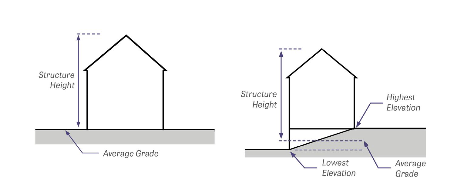

§1136.02 EXCEPTIONS TO HEIGHT MAXIMUMS. Elevator shafts and similar structural elements which are not intended as places of occupancy or storage; water and fire towers, cooling towers, ornamental towers, or spires; cupulas; smokestacks or chimneys; conveyors; bell towers or steeples; heating, ventilation, and air conditioning equipment and similar building mechanicals; and communication and radio transmission devices may extend above the structure height limit established by the district standards if they conform to the following requirements:
(A) For those structures that are mounted on a building’s roof, no more than one-third of the roof area may be used for such fixtures.
(B) For those fixtures affixed to the principal structure’s roof and providing at least the minimum setbacks established by the district in which it is located, no height-excepted fixture shall exceed the height limit of the district in which it is located by more than 15 vertical feet, except by a variance approved by the Board of Zoning Appeals. For information on variances, please refer to Title Seven “Administration and Procedures.”
(C) For solar panels and wind turbines, such structures shall conform to height maximums as described in Chapter 1153: “Renewable Energy Systems Regulations.”
(D) Note that, for accessory structures that are within the minimum setback area (for example, a child’s playhouse, which is an accessory structure, within 5 feet of the side lot line, where that district requires a side setback of at least 10 feet), no accessory
City of Garfield Heights, Ohio, Planning and Zoning Code
>Title One | Introduction to the Planning and Zoning Code 3
>>Chapter 1136: Rules of Measurement
structure shall exceed the maximum height described by §1151.08 “Height Maximums for Accessory Structures.”
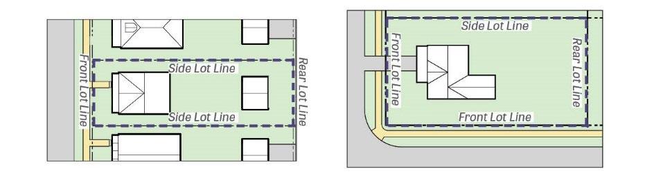
(A) Lot Line. A lot line is a line dividing one lot from another lot or from a street or any public place.
(B) Front Lot Line. A front lot line is a lot line dividing a lot from a public or private street and is the line from which the required front setback is measured. If a lot has more than one lot line that abuts a street right-of-way, such as is the case with a corner lot or a double-frontage lot, the lot may have more than one front lot line.
(C) Side Lot Line. A side lot line is any lot line not considered a front lot line or a rear lot line.
(D) Rear Lot Line. The rear lot line is the lot line which is most opposite the front lot line. Each lot shall have one rear lot line. In the case of a corner lot with more than one front lot line, the rear lot line is the lot line which is most opposite the shortest front lot line. In the case of an irregular or triangular-shaped lot, the rear lot line is a line 10 feet in length within the lot situated parallel to and at the maximum distance from the front lot line.

(E) Front Setback. A front setback is the shortest horizontal distance between a structure and the edge of the right-of-way. For a corner lot or a double-frontage lot, the front setback shall be measured from a structure and any of the front lot lines.
(F) Side Setback. A side setback is the shortest horizontal distance between a structure and a side lot line of the lot.
(G) Rear Setback. A rear setback is the shortest horizontal distance between a structure and a rear lot line of the lot.
(H) Exceptions to Setbacks. Certain accessory structures are permitted to encroach into setback areas; these situations are described in §1151.07 “Required Setbacks for Accessory Structures.”
City of Garfield Heights, Ohio, Planning and Zoning Code
>Title One | Introduction to the Planning and Zoning Code 4
>>Chapter 1136: Rules of Measurement
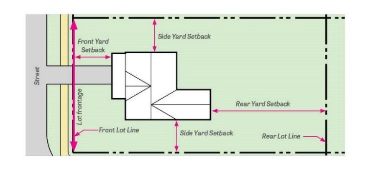

1136-03: Graphic showing lot lines and setbacks.
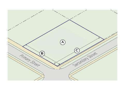
§1136.04 DEFINING LOT WIDTH. The lot width is the length of a lot’s shortest front lot line.

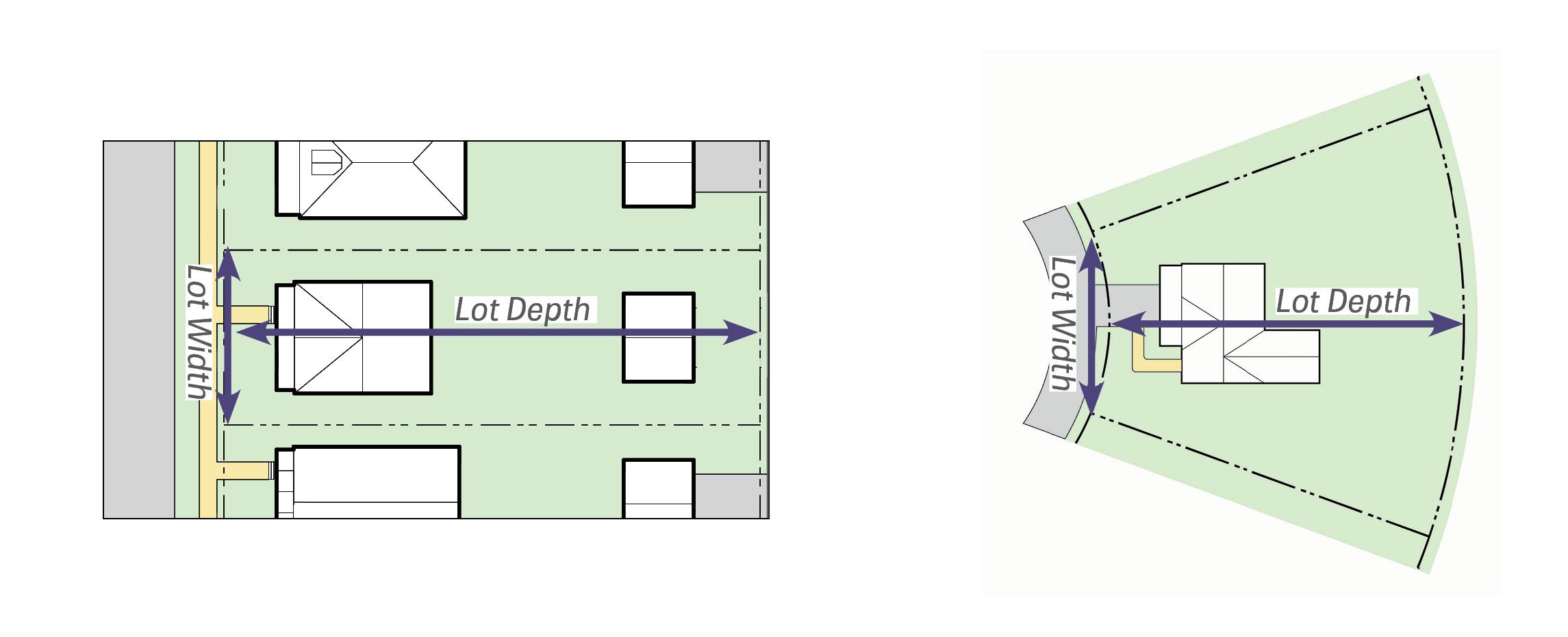
Figure 1136-04: Graphic showing lot width and lot depth measurements.
§1136.05 DEFINING LOT AREA. The lot area is the area of a horizontal plane bounded by vertical planes extending from the lot lines of a single lot, and not including any area within the right-of-way.
City of Garfield Heights, Ohio, Planning and Zoning Code
>Title One | Introduction to the Planning and Zoning Code 5
>>Chapter 1136: Rules of Measurement
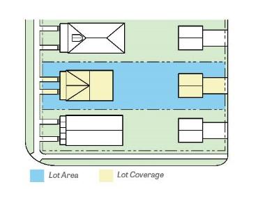

Figure 1136-05: Graphic showing lot area (all area in blue added to area in yellow) and lot coverage (all area in yellow only)
§1136.06 DEFINING BUILDING FOOTPRINT. Building footprint is the area of an individual building (as viewed from a plan view, where topography of the land is irrelevant). When measuring building footprint, the area only considers the extent of the exterior of building walls but shall not take into consideration roof overhangs, eaves, awnings, or canopies. It shall, however, include those areas of the building with walls that represent a larger areas than the area of the footprint of the foundation, such as cantilevered sections of the building. Building footprint shall also include areas of the building with half-walls, such as porches.
City of Garfield Heights, Ohio, Planning and Zoning Code
>Title One | Introduction to the Planning and Zoning Code 6
>>Chapter 1136: Rules of Measurement
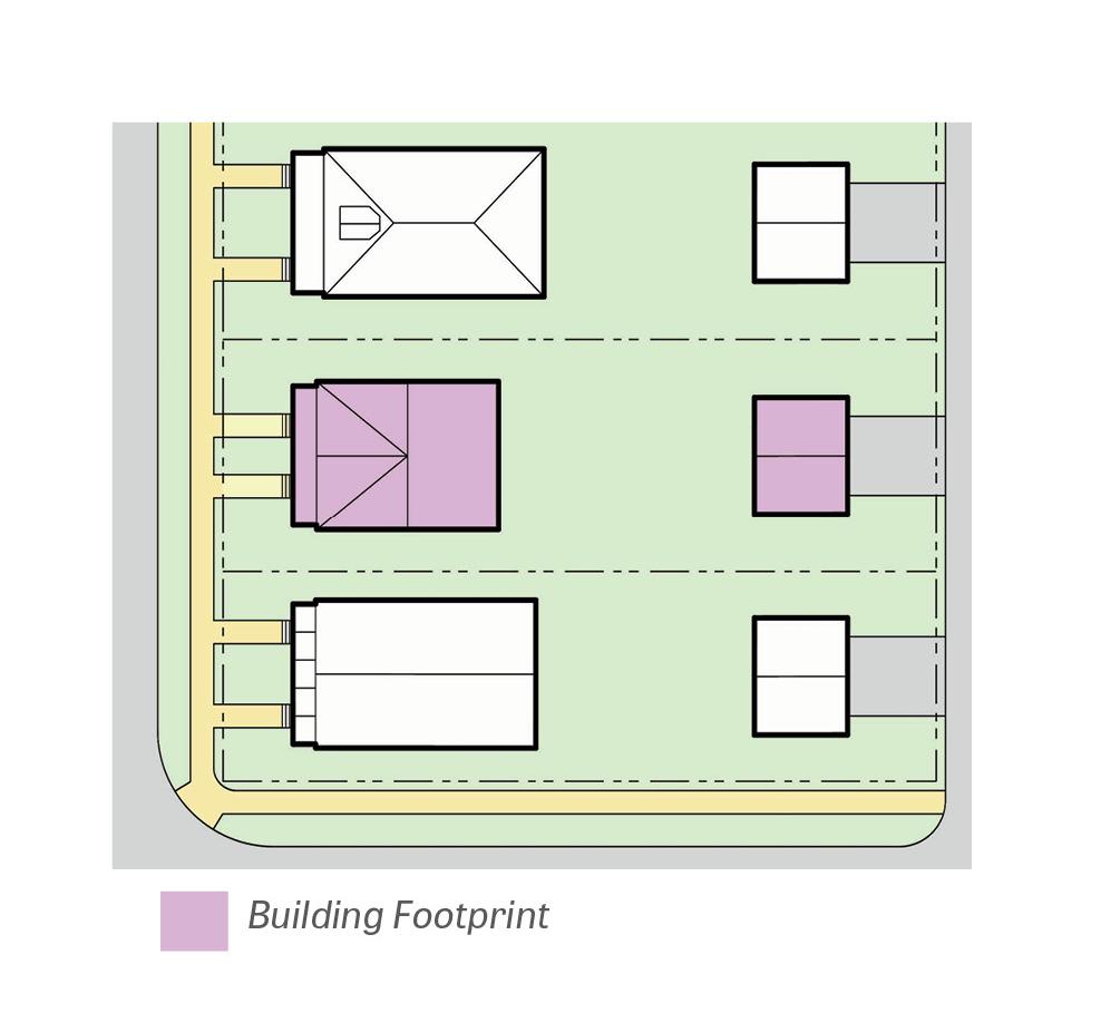

Figure 1136-06: Graphic showing building footprint (all area in pink) as the measure of the area underneath the building, typically equal to the area of the ground floor.
City of Garfield Heights, Ohio, Planning and Zoning Code
>Title One | Introduction to the Planning and Zoning Code
>>Chapter 1136: Rules of Measurement
§1137.01 ZONING DISTRICTS. To achieve the purposes of this Code, the City of Garfield Heights is hereby divided and classified into the districts established in this chapter.
§1137.02 ESTABLISHMENT OF ZONING MAP
(A) The district classification of all land in the City shall be shown on the map designated as the City Zoning District Map, dated and signed by the Clerk of Council upon adoption.
(B) The Zoning District Map and all amendments thereto shall be as much a part of this Code as if fully described herein and shall be filed as part thereof by the Clerk of Council. The Map shall be available for public inspection in the Building Department. Any amendments to this Map shall be similarly dated, filed, and made available for public reference.
§1137.03 LIST OF DISTRICTS. The City of Garfield Heights includes the following base zoning districts:
(A) Additionally, the City of Garfield Heights contains the following overlay zoning districts. An overlay zoning district may be applied in areas of the city within the boundaries of base zoning districts; in such cases, the more restrictive regulations shall govern.
City of Garfield Heights, Ohio, Planning and Zoning Code
>Title Two | Zoning District Standards
>>Chapter 1137: Introduction to Zoning Districts
(A) All developments and uses must conform to the standards set forth in this chapter.
(B) Additional applicable development standards are included elsewhere in the Zoning Code.
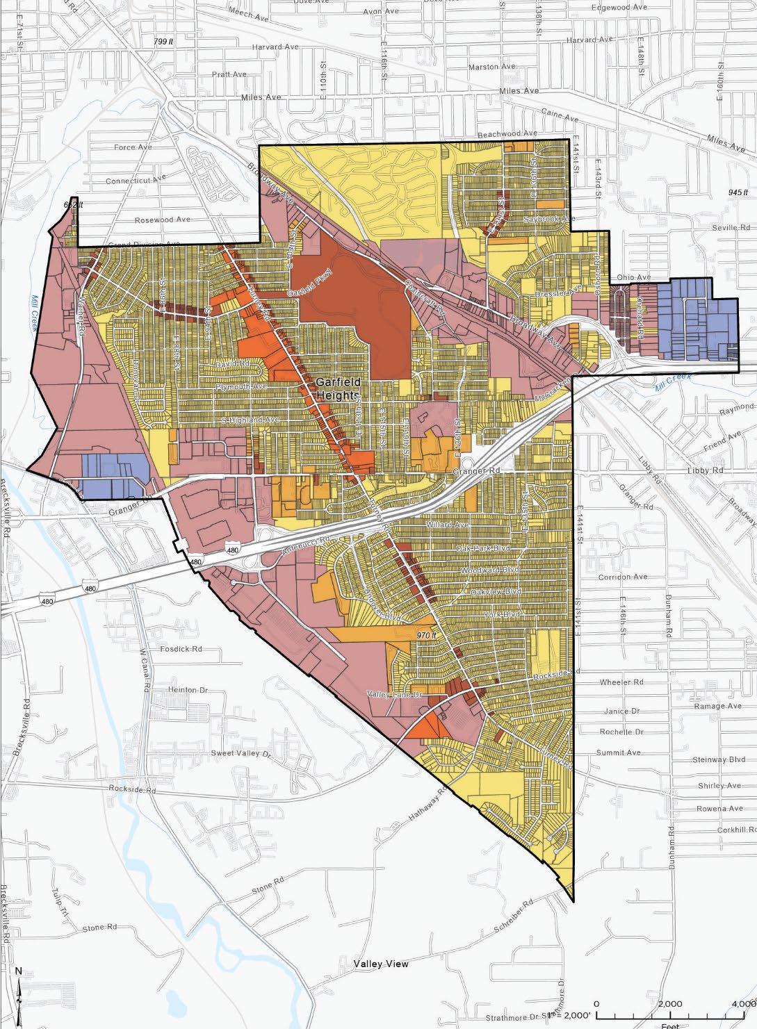
Figure 1137-01: Zoning Districts. Please note that this zoning map may have been modified over time, and this version may not reflect recent changes; please see the City’s website for the most current version of the zoning map.
City of Garfield Heights, Ohio, Planning and Zoning Code
>Title Two | Zoning District Standards 9
>>Chapter 1137: Introduction to Zoning Districts
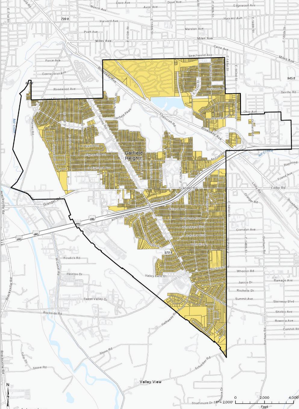
Figure 1138-01: Map of the Residential 1 (RES1) District. Please note that this zoning map may have been modified over time, and this version may not reflect recent changes; please see the City’s website for the most current version of the zoning map.
City of Garfield Heights, Ohio, Planning and Zoning Code
>Title Two | Zoning District Standards
>>Chapter 1138: Residential 1 (RES1) District

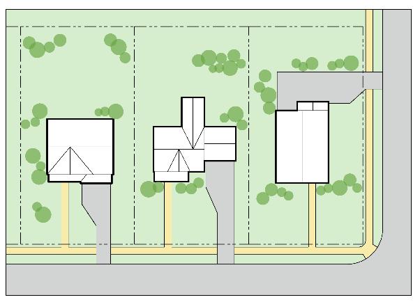
(A) The Residential 1 District intends to promote one- and two-unit dwellings and compatible civic uses in the majority of Garfield Heights's residential neighborhoods and promote balance between the preservation of existing neighborhood character and the promotion of neighborhood investment and housing diversity.
City of Garfield Heights, Ohio, Planning and Zoning Code
>Title Two | Zoning District Standards
>>Chapter 1138: Residential 1 (RES1) District
§1138.02
(A) Number of Uses per Lot. No more than one principal use is permitted per lot in the Residential 1 District.
(B) Accessory Uses. Accessory uses shall be permitted in accordance with accessory use regulations found in Chapter 1151
(C) Uses Restricted. No building or land within the Residential 1 District shall be used for any purpose other than for a purpose included in the list of allowed uses below. Additional use regulations of Chapter 1150 shall apply. All use terms are defined in this Planning and Zoning Code’s Glossary in Chapter 1205
Allowed Uses in the RES1 District Required Approval Process Reference to Specific Regulations
RESIDENTIAL USES
One-Unit Residential Administrative Review §1150.22
Two -Unit Residential Administrative Review §1150.32
3-8-Unit Residential Conditional Use Review §1150.02
Townhouse Residential Conditional Use Review §1150.31
Cottage Court Residential Conditional Use Review §1150.08
Residential Care Housing Conditional Use Review §1150.28
INSTITUTIONAL USES
Indoor Recreation/Community Centers Conditional Use Review §1150.14
Libraries, Museums, Playhouses, and Places of Worship Conditional Use Review §1150.18
Schools Conditional Use Review §1150.29
OPEN SPACE USES
Community Agriculture Administrative Review §1150.07
Preserves Administrative Review §1150.27
Sports Fields and Outdoor Recreation Conditional Use Review §1150.30
MISCELLANEOUS USES
Accessory Uses Administrative Review Chapter 1151
Temporary Uses Administrative Review Chapter 1152
City of Garfield Heights, Ohio, Planning and Zoning Code
>Title Two | Zoning District Standards
>>Chapter 1138: Residential 1 (RES1) District
B
(A) No lot may be created which does not conform with the lot size standards listed below.
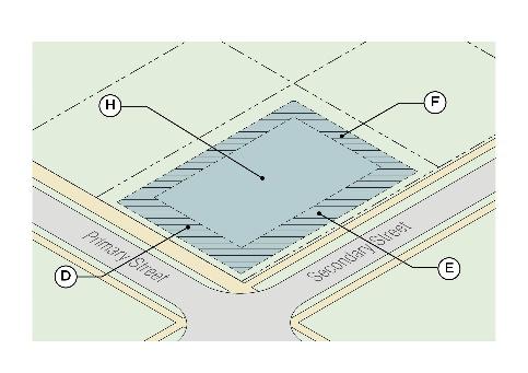
(B) No building shall be erected or modified unless such building or the modified portion of such building conforms with the yard setback and building scale standards listed below.
for minor subdivisions*;
for major subdivisions*
E
5 ft. min.* on any side without a driveway; 10 ft. min. on any side with a driveway (measured between the structure and the side lot line) F
Yard
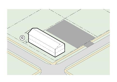
* (asterisk) indicates that special requirements may apply for townhouse development; please see townhouse provisions in §1150.31
(A) Parking and Driveway Regulations. Parking and driveway regulations can be found in this Planning and Zoning Code Chapter 1155 “Parking Standards”.
(B) Fence Regulations. Fence regulations can be found in this Planning and Zoning Code Chapter 1157 “Fence Standards”.
(C) Construction Stormwater Controls Stormwater regulations for construction sites that may disturb one acre or greater, as well as other environmental standards such as hillside and floodplain protections, can be found in this Planning and Zoning Code Title Six "Environmental Regulations”
(D) Outdoor Storage Regulations. Outdoor storage regulations can be found in this Planning and Zoning Code Chapter 1160 “Dumpsters and Outdoor Storage Standards”.
(E) Noise Regulations. Noise levels are regulated by the Noise Control chapter of the Codified Ordinances of Garfield Heights and is not included in this Planning and Zoning Code; please contact the City of Garfield Heights for details on noise control provisions
(F) Building Code Regulations. All new buildings and modifications to buildings must adhere to the City of Garfield Heights building code. The building code is not included in this Planning and Zoning Code; please contact the City of Garfield Heights Building Department for details on conforming to the building code.
City of Garfield Heights, Ohio, Planning and Zoning Code
>Title Two | Zoning District Standards
>>Chapter 1138: Residential 1 (RES1) District
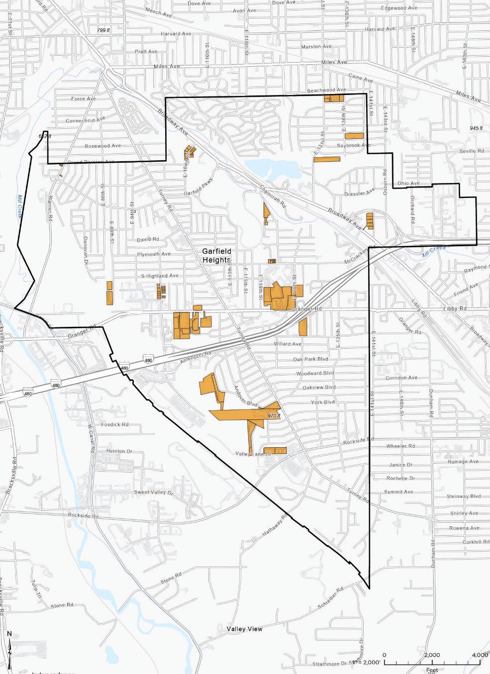
Figure 1139-01: Map of the Residential 2 (RES2) District. Please note that this zoning map may have been modified over time, and this version may not reflect recent changes; please see the City’s website for the most current version of the zoning map.
City of Garfield Heights, Ohio, Planning and Zoning Code
>Title Two | Zoning District Standards
>>Chapter 1139: Residential 2 (RES2) District
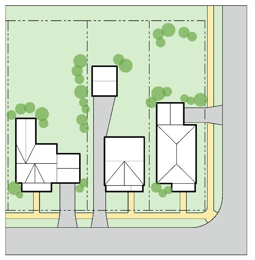

Figure 1139-02: Potential development style of the Residential 2 District.
§1139.01 INTENT OF THE RESIDENTIAL 2 DISTRICT. The Residential 2 District intends to promote multi-unit dwellings and compatible civic uses.
City of Garfield Heights, Ohio, Planning and Zoning Code
>Title Two | Zoning District Standards 16
>>Chapter 1139: Residential 2 (RES2) District
§1139.02
(A) Number of Uses per Lot. No more than one principal use is permitted per lot in the Residential 2 District.
(B) Accessory Uses. Accessory uses shall be permitted in accordance with accessory use regulations found in Chapter 1151
(C) Uses Restricted. No building or land within the Residential 2 District shall be used for any purpose other than for a purpose included in the list of allowed uses below. Additional use regulations of Chapter 1150 shall apply. All use terms are defined in this Planning and Zoning Code’s Glossary in Chapter 1205
Allowed Uses in the RES2 District Required Approval Process Reference to Specific Regulations
RESIDENTIAL USES
One-Unit Residential Conditional Use Review §1150.22
Two -Unit Residential Conditional Use Review §1150.32
3-8-Unit Residential Administrative Review §1150.02
9-Plus-Unit Residential Administrative Review §1150.03
Townhouse Residential Administrative Review §1150.31
Cottage Court Residential Administrative Review §1150.08
Residential Care Housing Administrative Review §1150.28
INSTITUTIONAL USES
Indoor Recreation/Community Centers Conditional Use Review §1150.14
Libraries, Museums, Playhouses, and Places of Worship Conditional Use Review §1150.18
Schools Conditional Use Review §1150.29
OPEN SPACE USES
Community Agriculture Administrative Review §1150.07
Preserves Administrative Review §1150.27
Sports Fields and Outdoor Recreation Conditional Use Review §1150.30
MISCELLANEOUS USES
Accessory Uses Administrative Review Chapter 1151
Temporary Uses Administrative Review Chapter 1152
City of Garfield Heights, Ohio, Planning and Zoning Code
>Title Two | Zoning District Standards 17
>>Chapter 1139: Residential 2 (RES2) District
§1139.03
(A) No lot may be created which does not conform with the lot size standards listed below.
(B) No building shall be erected or modified unless such building or the modified portion of such building conforms with the yard setback and building scale standards listed below. Development Standards
YARD SETBACK STANDARDS
D Front Yard Setback 25 ft. min. from public rightof-way *; no min. from private drive
E Side Yard Setback
min. per side * F Rear Yard
BUILDING SCALE STANDARDS
NOTES
* (asterisk) indicates that special requirements may apply for townhouse development or cottage court development; please see townhouse provisions in §1150.31 and cottage court provisions in §1150.08
City of Garfield Heights, Ohio, Planning and Zoning Code
>Title Two | Zoning District Standards 18
>>Chapter 1139: Residential 2 (RES2) District
(A) Parking and Driveway Regulations. Parking and driveway regulations can be found in this Planning and Zoning Code Chapter 1155 “Parking Standards”.
(B) Fence Regulations. Fence regulations can be found in this Planning and Zoning Code Chapter 1157 “Fence Standards”.
(C) Construction Stormwater Controls Stormwater regulations for construction sites that may disturb one acre or greater, as well as other environmental standards such as hillside and floodplain protections, can be found in this Planning and Zoning Code Title Six "Environmental Regulations”.
(D) Outdoor Storage Regulations. Outdoor storage regulations can be found in this Planning and Zoning Code Chapter 1160 “Dumpsters and Outdoor Storage Standards”.
(E) Noise Regulations. Noise levels are regulated by the Noise Control chapter of the Codified Ordinances of Garfield Heights and is not included in this Planning and Zoning Code; please contact the City of Garfield Heights for details on noise control provisions.
(F) Building Code Regulations. All new buildings and modifications to buildings must adhere to the City of Garfield Heights building code. The building code is not included in this Planning and Zoning Code; please contact the City of Garfield Heights Building Department for details on conforming to the building code.
City of Garfield Heights, Ohio, Planning and Zoning Code >Title Two | Zoning District Standards
>>Chapter 1139: Residential 2 (RES2) District
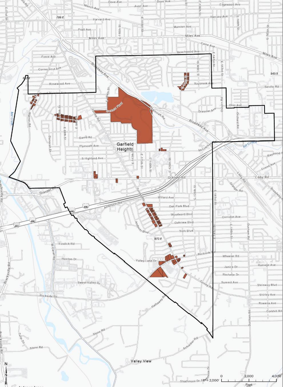
Figure 1140-01: Map of the Neighborhood Mixed-Use (NMU) District. Please note that this zoning map may have been modified over time, and this version may not reflect recent changes; please see the City’s website for the most current version of the zoning map.
City of Garfield Heights, Ohio, Planning and Zoning Code
>Title Two | Zoning District Standards
>>Chapter 1140: Neighborhood Mixed-Use (NMU) District
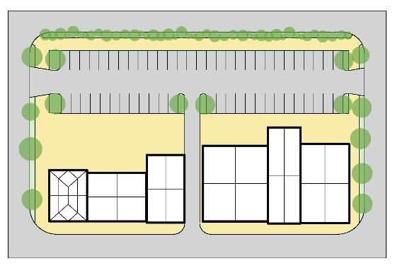

§1140.01 INTENT OF THE NEIGHBORHOOD MIXED-USE DISTRICT. The Neighborhood Mixed-Use District intends to promote a diversity of pedestrian-scaled land uses compatible with and within walking distance of Garfield Heights' housing areas.
§1140.02 USES IN THE NEIGHBORHOOD MIXED-USE DISTRICT.
(A) Number of Uses per Lot. More than one principal use is permitted per lot in the Neighborhood Mixed-Use District.
(B) Accessory Uses. Accessory uses shall be permitted in accordance with accessory use regulations found in Chapter 1151
(C) Uses Restricted. No building or land within the Neighborhood Mixed-Use District shall be used for any purpose other than for a purpose included in the list of allowed uses below. Additional use regulations of Chapter 1150 shall apply. All use terms are defined in this Planning and Zoning Code’s Glossary in Chapter 1205
City of Garfield Heights, Ohio, Planning and Zoning Code
>Title Two | Zoning District Standards
>>Chapter 1140: Neighborhood Mixed-Use (NMU) District
Indoor Dining, Drinking, and Entertainment Administrative Review §1150.13
Indoor Sales and Services Administrative Review §1150.15
Lodging Administrative Review §1150.20
Outdoor Dining, Drinking, and Entertainment Conditional Use Review §1150.23
INSTITUTIONAL USES
Indoor Recreation/Community Centers Administrative Review §1150.14
Libraries, Museums, Playhouses, and Places of Worship Administrative Review §1150.18
Schools Conditional Use Review §1150.29
OPEN SPACE USES
Community Agriculture
Preserves
Sports Fields and Outdoor Recreation
MISCELLANEOUS USES
Review §1150.07
Review §1150.27
Review §1150.30
Accessory Uses Administrative Review Chapter 1151
Temporary Uses Administrative Review Chapter 1152
City of Garfield Heights, Ohio, Planning and Zoning Code
>Title Two | Zoning District Standards
>>Chapter 1140: Neighborhood Mixed-Use (NMU) District
(A) No lot may be created which does not conform with the lot size standards listed below.
(B) No building shall be erected or modified unless such building or the modified portion of such building conforms with the yard setback and building scale standards listed below.
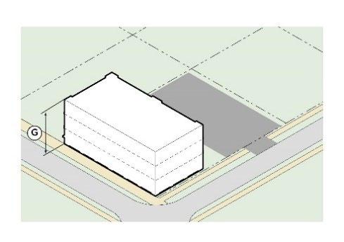
* (asterisk) indicates that special requirements may apply for townhouse development; please see townhouse provisions in §1150.31
** (double asterisk) indicates that special building code requirements may apply for adjacent structures; please see the City’s building code regulations
City of Garfield Heights, Ohio, Planning and Zoning Code >Title Two | Zoning District Standards 23 >>Chapter 1140: Neighborhood
(A) Parking and Driveway Regulations. Parking and driveway regulations can be found in this Planning and Zoning Code Chapter 1155 “Parking Standards”.
(B) Fence Regulations. Fence regulations can be found in this Planning and Zoning Code Chapter 1157 “Fence Standards”.
(C) Construction Stormwater Controls Stormwater regulations for construction sites that may disturb one acre or greater, as well as other environmental standards such as hillside and floodplain protections, can be found in this Planning and Zoning Code Title Six "Environmental Regulations”.
(D) Outdoor Storage Regulations. Outdoor storage regulations can be found in this Planning and Zoning Code Chapter 1160 “Dumpsters and Outdoor Storage Standards”.
(E) Noise Regulations. Noise levels are regulated by the Noise Control chapter of the Codified Ordinances of Garfield Heights and is not included in this Planning and Zoning Code; please contact the City of Garfield Heights for details on noise control provisions.
(F) Building Code Regulations. All new buildings and modifications to buildings must adhere to the City of Garfield Heights building code. The building code is not included in this Planning and Zoning Code; please contact the City of Garfield Heights Building Department for details on conforming to the building code.
City of Garfield Heights, Ohio, Planning and Zoning Code
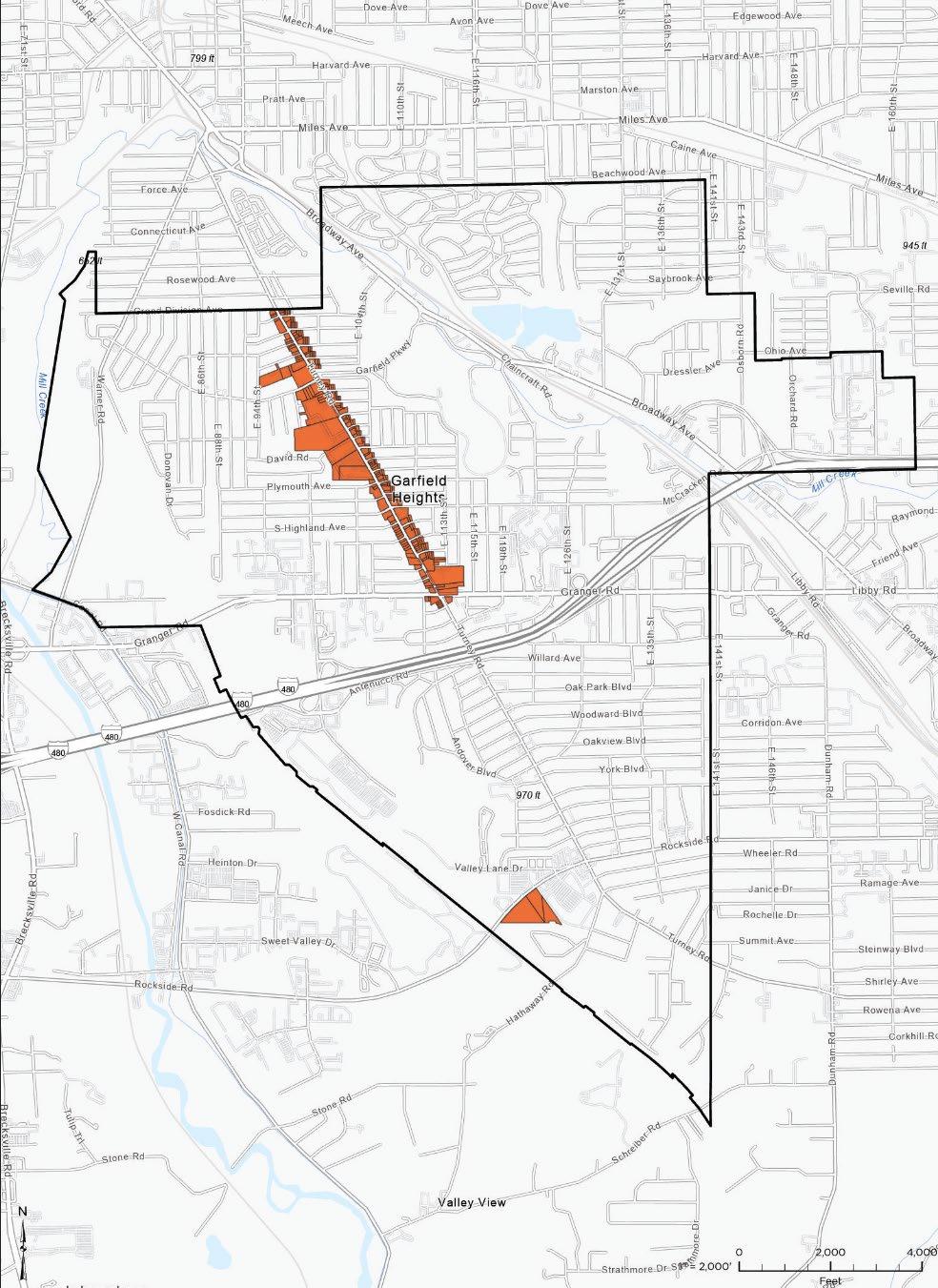
Figure 1141-01: Map of the Turney Road Core Mixed-Use (TRCMU) District. Please note that this zoning map may have been modified over time, and this version may not reflect recent changes; please see the City’s website for the most current version of the zoning map.
City of Garfield Heights, Ohio, Planning and Zoning Code
>Title Two | Zoning District Standards 25
>>Chapter 1141: Turney Road Core Mixed-Use (TRCMU) District
§1141.01 INTENT OF THE TURNEY ROAD CORE MIXED-USE DISTRICT. The Turney Road Core Mixed-Use District intends to promote a walkable, transit-accessible, mixed-use district in the heart of Garfield Heights that serves local residents, employees, and visitors with a variety of main street-scaled land uses.
§1141.02 USES IN THE TURNEY ROAD CORE MIXED-USE DISTRICT
(A) Number of Uses per Lot. More than one principal use is permitted per lot in the Turney Road Core Mixed-Use District.
(B) Accessory Uses. Accessory uses shall be permitted in accordance with accessory use regulations found in Chapter 1151.
(C) Uses Restricted. No building or land within the Turney Road Core Mixed-Use District shall be used for any purpose other than for a purpose included in the list of allowed uses below. Additional use regulations of Chapter 1150 shall apply. All use terms are defined in this Planning and Zoning Code’s Glossary in Chapter 1205
City of Garfield Heights, Ohio, Planning and Zoning Code
>Title Two | Zoning District Standards
>>Chapter 1141: Turney Road Core Mixed-Use (TRCMU) District
Allowed Uses in the TRCMU District Required Approval Process Reference to Specific Regulations
RESIDENTIAL USES
One-Unit Residential Administrative Review §1150.22
Two -Unit Residential Administrative Review §1150.32
3-8-Unit Residential Administrative Review §1150.02
9-Plus-Unit Residential Administrative Review §1150.03
Townhouse Residential Administrative Review §1150.31
Residential Care Housing Administrative Review §1150.28
COMMERCIAL USES
Craft and Art Industrial Administrative Review §1150.09
Indoor Dining, Drinking, and Entertainment Administrative Review §1150.13
Indoor Sales and Services Administrative Review §1150.15
Large Indoor Events Center Administrative Review §1150.16
Lodging Administrative Review §1150.20
Outdoor Dining, Drinking, and Entertainment Conditional Use Review §1150.23
INSTITUTIONAL USES
Indoor Recreation/Community Centers Administrative Review §1150.14
Libraries, Museums, Playhouses, and Places of Worship Administrative Review §1150.18
Schools Administrative Review §1150.29
OPEN SPACE USES
Community Agriculture Administrative Review §1150.07
Preserves Administrative Review §1150.27
Sports Fields and Outdoor Recreation Administrative Review §1150.30
MISCELLANEOUS USES
Accessory Uses Administrative Review Chapter 1151
Temporary Uses Administrative Review Chapter 1152
City of Garfield Heights, Ohio, Planning and Zoning Code
>Title Two | Zoning District Standards 27
>>Chapter 1141: Turney Road Core Mixed-Use (TRCMU) District
(A) No lot may be created which does not conform with the lot size standards listed below.
(B) No building shall be erected or modified unless such building or the modified portion of such building conforms with the yard setback and building scale standards listed below.
D Front Yard Setback 0 ft. min.; 40 ft. max.
E Side Yard Setback
F Rear Yard Setback
BUILDING SCALE STANDARDS
G Building Height
Building Footprint
0 ft. min. per side** where abutting another lot in the TRCMU District; 20 ft. min. per side where abutting any other district
5 ft. min.* where abutting another lot in the TRCMU District; 20 ft. min. where abutting any other district
22 ft. min. and 75 ft. max.; however, no portion of a building within 40 horizontal feet of a property in the RES1 District shall exceed 40 ft. in height
35,000 sq. ft. max.; larger structures may be permitted through a variance process (see Chapter 1188).
Lot Coverage N/A
Building Frontage
At least 60% of lot width at front yard setback line must be occupied by building
* (asterisk) indicates that special requirements may apply for townhouse development; please see townhouse provisions in §1150.31
** (double asterisk) indicates that special building code requirements may apply for adjacent structures; please see the City’s building code regulations

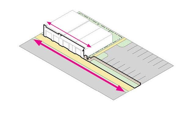
Figure 1141-03: Graphic showing the Building Frontage percentage. The thick pink line represents the lot width, and the thin pink line represents the building’s width. The Building Frontage percentage is the width of the thin pink line divided by the width of the thick pink line, multiplied by 100.
(A) Applicability of Design Standards. These design standards shall apply to any new development or any redevelopment of an existing building that results in an addition or expansion of 30% or more of square footage of the existing building, where such new development or redevelopment is within the Turney Road Core Mixed-Use District. However, these design standards shall not apply to new developments or redevelopments that do not have a visual effect or change to Turney Road; for example, certain areas or lots within the Turney Road Core Mixed-Use District may not be visible to Turney Road because they are blocked by other lots or structures these areas or lots are not subject to these design standards. Furthermore, only a change of use of an existing structure and not an alteration of such structure shall not require conformity with these design standards.
(B) Transition Zone Required. Any portion of the Turney Road Core Mixed-Use District within 40 feet of the Residential 1 District shall be considered a Transition Zone. Within this Transition Zone, the massing and scale of new construction should consider its surrounding context in the following ways:
City of Garfield Heights, Ohio, Planning and Zoning Code
>Title Two | Zoning District Standards
>>Chapter 1141: Turney Road Core Mixed-Use (TRCMU) District
(i) Stepping back upper stories or adjusting the roof pitch of larger massed buildings on the side where they are adjacent to smaller massed buildings.
(ii) Including additional buffer space between larger massed buildings and smaller massed buildings. This buffer space is an appropriate area for drives, landscaping, and open space.
(iii) Including horizontal architectural details such as cornices and window frames on larger massed buildings that align with the roofline of the adjacent smaller massed buildings.
(iv) Using trees and other greenery to soften hard edges between differently massed buildings.
(C) Entryway Requirements. The building’s architecture shall emphasize the main entryway to the building, and the main entryway shall face Turney Road or, for corner lots, the corner of Turney Road and an intersecting street. To avoid pedestrian conflicts, no public entrance door whether hinged, rotary, or sliding may have a pivot point or slide-track within three feet of the public right-of-way.

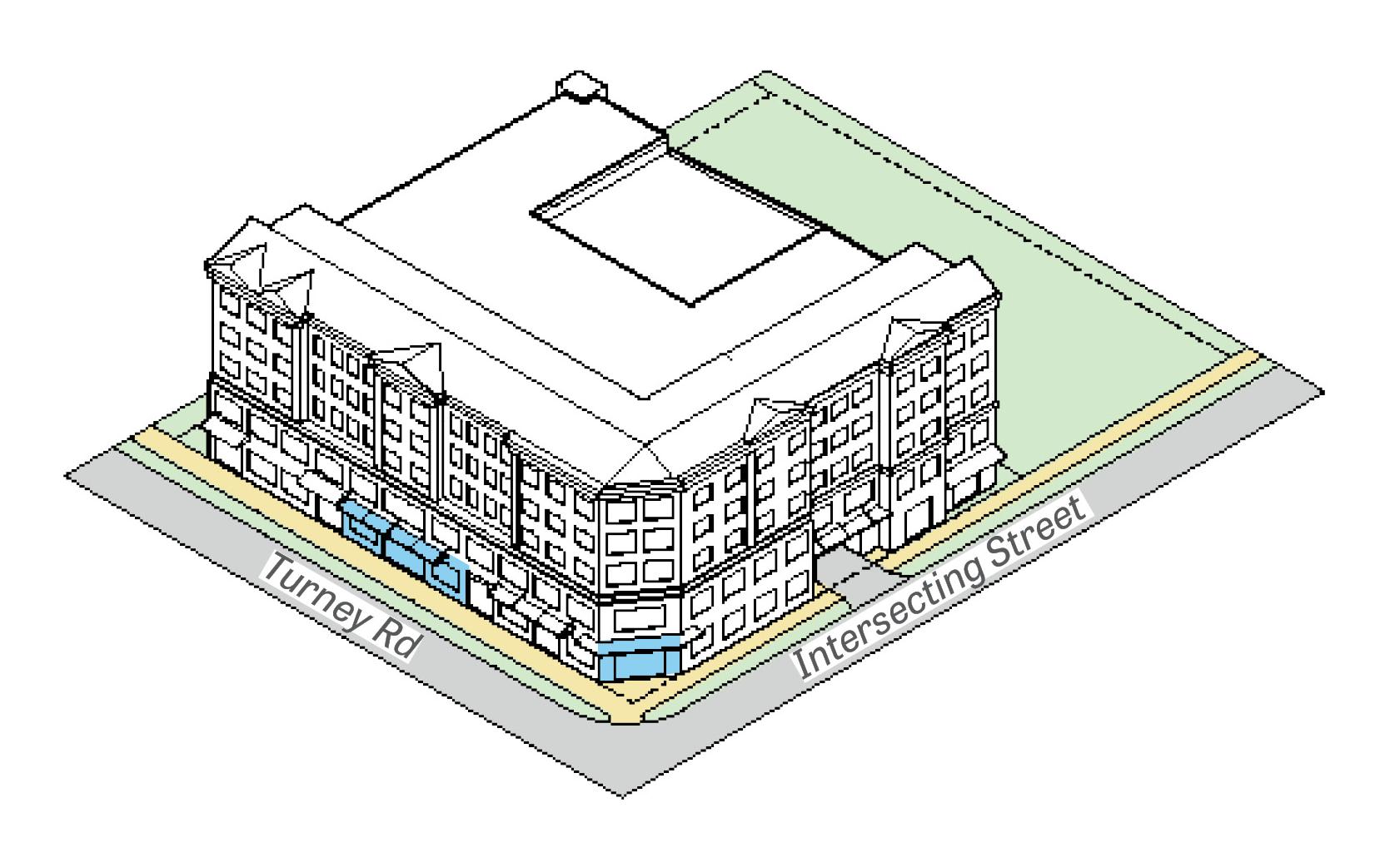
(D) Transparent Windows Required. At least 40% of the surface area of any wall facing Turney Road that is parallel to or nearly parallel to Turney Road between the ground level and eight feet of height shall consist windows None of the required windows shall be tinted greater than 20% nor shall be blocked by films, paper, or other materials. This provision is meant to activate the pedestrian environment, enhancing visual interest, and is meant to increase visibility for law enforcement personnel needing to see inside of a building.

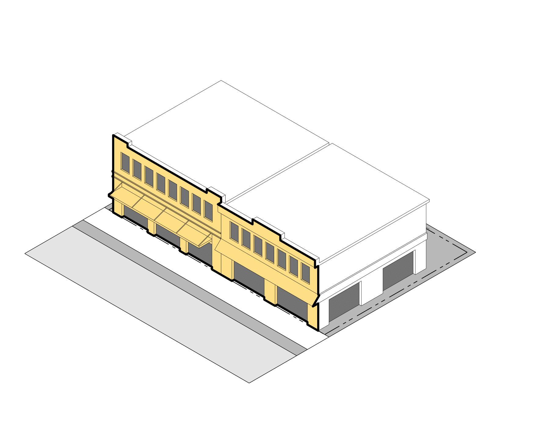
Figure 1141-05: Graphic showing the transparency of a building’s front façade. In this building, the transparency percentage is the area of transparent glass (the windows are shown in gray) divided by the total front façade area (represented by yellow, plus the gray window area), and then multiplied by 100. Please note that, in this example, both the first floor and the second floor are considered, but the regulation in this Planning and Zoning Code may consider transparency only for the first floor.
(E) Activated Frontages Required. Any interior space of a building visible from Turney Road shall be of a non-residential nature to a depth of at least 15 feet into the building, so as to activate the street frontage. For the purposes of this definition, an activated use may include a commercial use, such as offices, retail stores, or food service establishments; public spaces, such as atria, lobbies, or meeting rooms; or residentialamenity spaces, such as gyms or pools. Stairs, storage, hallways, elevators, and indoor parking do not qualify as active uses
(F) Anti-Monotony Techniques Required. Large-scale commercial and mixed-use buildings should include architectural or material-based articulation to reduce the perceived mass of the building while still aligning with the built context of the block, which can be achieved using any of the following techniques:
(i) For larger buildings, particularly buildings that fill an entire block, using engaging ground-level design and providing multiple pedestrian entry points along the frontage.
City of Garfield Heights, Ohio, Planning and Zoning Code
(ii) Avoiding large, monolithic buildings by breaking the facade down to appear as multiple smaller buildings.
(iii) Incorporating architectural elements such as recessed or protruding entrances, balconies, bay windows, brick patterns, etc.
(iv) Ensuring the pattern or repetition of any chosen architectural feature, recess, projection, or break is regular, intentional, and predictable.
(G) Transit Consideration Required. Existing and future transit stops should be considered in the layout of new developments to ensure convenient transit access and use. The location of entrances, walkways, and pedestrian amenities should allow for convenient, safe, and comfortable pedestrian access from a transit stop to the site.
(H) Pedestrian Amenities Required
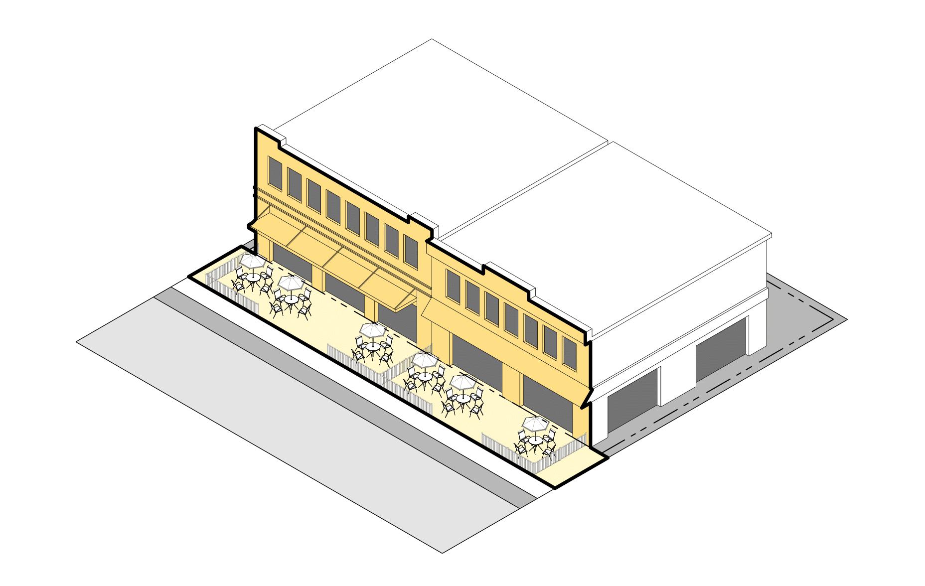
(i) Outdoor dining and seating areas are encouraged but should maintain at least six feet of unobstructed walking space along sidewalks.

(ii) Pedestrian amenities such as benches, lighting, and trash and recycling receptacles should be conveniently placed together.
(iii) Overhead weather protection such as awnings, overhangs, and arcades are encouraged and should be appropriately located to clearly define building entries and orient towards pedestrian areas. Where possible, overhead weather protection should be located to provide shelter to waiting transit users. Please note that permanently installed overhead weather protection,
such as awnings, overhangs, and arcades, in the public right-of-way require permission from the City for such public right-of-way encroachments.
(i) No development site of one acre or less shall be permitted more than one curb cut onto Turney Road; and no development site of more than one acre shall be permitted more than two curb cuts onto Turney Road.
(ii) All surface parking lots shall be designed so that driveway access is off of a secondary street or alley, when such secondary street or alley can be accessed from the site.
(iii) Parking area access may be achieved through inter-parcel connection to a street or alley, with approval of the Building Commissioner. Wherever possible, parking lots on adjacent properties shall be designed to allow for shared driveway access and internal circulation between the parking areas so as to reduce the number of curb cuts along the street. The design of any new parking lot shall anticipate and not preclude future inter-parcel connections from adjoining lots, if at all possible. On lots utilizing a cooperative parking agreement or part of a common development, parking areas may abut or cross lot lines
(iv) Driveways/parking area accessways shall be a minimum of 100 feet from any intersection, as measured from the driveway/parking area accessway center line to any intersection, as shown in the figure below
(v) Driveways/ parking area accessways must be located a minimum of 250 feet away from any other existing or proposed driveway/ parking area accessway along the same street frontage, provided, however, that all developments are allowed at least one driveway/ parking area accessway, as shown the figure below
(vi) Distances between driveways/parking area accessways shall be measured along the right-of-way line from the center line of the proposed driveway/parking area accessway at the right-of-way to the center line at the right-of-way of any other proposed or existing driveway/parking area accessway.
(vii) No parking area accessway may be wider than 36 feet

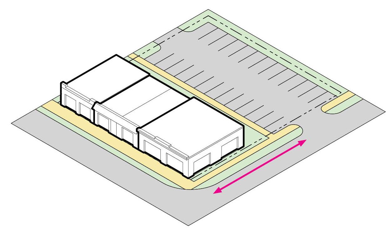
1141-07: Figure showing the separation of the parking lot accessway and the nearest intersection (represented by the pink arrow).
(i) Garages, parking spaces, and driveways should be designed to be as discreet as possible and limit impediments to the walking environment.
(ii) Garage openings should be placed where it will have the least disruption to pedestrian walkways and limit potential conflict points between car traffic and pedestrians.
(iii) Buildings should be arranged on the site such that garages should be placed behind buildings whenever possible, and parking entrances should be accessed via secondary streets.
(iv) Whenever garages face a primary street, they should be lined by buildings that screen the parking structure from view and incorporate other uses such as residential, retail, and active uses.


1141-08: An upper-floor parking garage in the Design District of Miami, Florida, with screening, as suggested by these design standards.
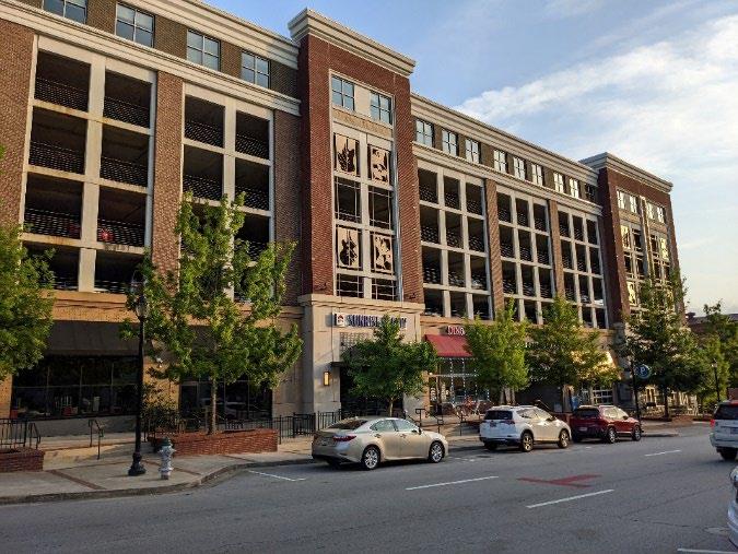

1141-09: A parking garage in Athens, Georgia, that epitomizes these design standards’ requirements to “incorporate architectural design that complements the primary structure through the use of facade articulation, architectural elements, color, and elements that break up the mass of the garage.”
(v) Garages that are visible from a public street should avoid blank walls. These garages should be screened using landscaping or public art, or should incorporate architectural design that complements the primary structure through the use of facade articulation, architectural elements, color, and
City of Garfield Heights, Ohio, Planning and Zoning Code
>Title Two | Zoning District Standards
>>Chapter 1141: Turney Road Core Mixed-Use (TRCMU) District
elements that break up the mass of the garage. Fabric screening of parking garages is discouraged.
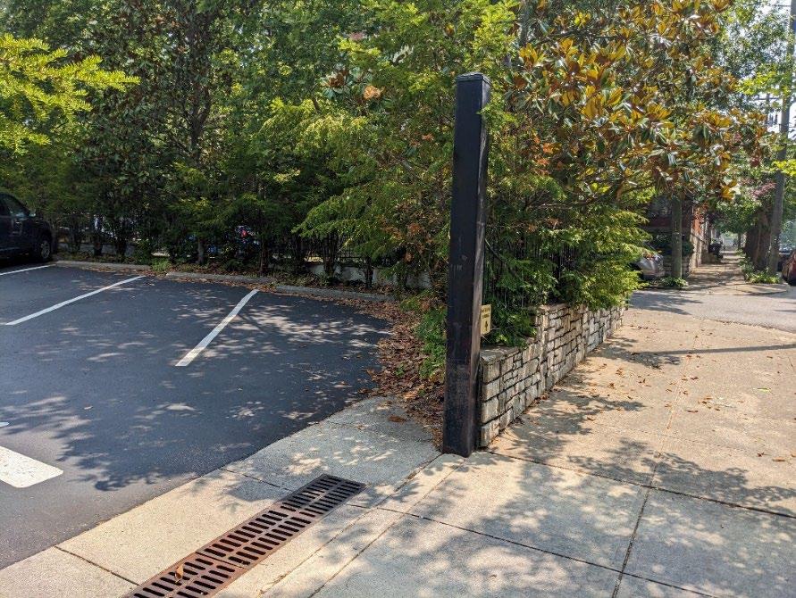
(vi) Surface parking lots visible from Turney Road shall be screened from the sidewalk with a wall, hedgerow, or decorative fence of at least three feet in height. Such wall, hedgerow, or decorative fence may be broken only to facilitate pedestrian passageways or parking area accessways.

(K) Landscaping Plan Required. A Landscaping Plan shall be submitted for the entire site. The Landscaping Plan shall include all of the following:
(i) A site plan showing the location of all existing and proposed landscaping, open space, screening, and other site features.
(ii) Property boundaries, building location(s), parking lot layout, service areas, mechanical equipment, pedestrian paths, adjacent rights-of way, north arrow, and scale.
(iii) The location, quantity, size at planting and at maturity, and name, both botanical and common names, of all proposed planting materials, including ground cover.
(iv) Any other information and data deemed necessary by the Building Commissioner.
City of Garfield Heights, Ohio, Planning and Zoning Code
(i) A Streetscaping Plan shall be submitted for the entire site. The Streetscaping Plan shall include the following items:
(1) A plan showing the location and relationship between vehicular and pedestrian traffic, and all existing and proposed pedestrian facilities, street and sidewalk lighting, landscaping, street furniture, lighting fixtures, trash receptacles, and transit stops
(2) Property boundaries, building location(s), parking lot layout, pedestrian paths, and adjacent rights-of way.
(3) Specifications and drawings or photographs for all street furniture, trash receptacles, and transit stops.
(4) The location, quantity, size at planting and at maturity, and name, both botanical and common names, of all proposed planting materials, including ground cover.
(5) Any other information and data deemed necessary by the Building Commissioner
(ii) Street trees shall be planted within tree lawns along all public rights-of-way.
(1) A minimum of one large tree shall be planted for every development site, and street trees shall be planted at intervals of no more than 30 feet on-center, on average.
(2) Where overhead utilities exist, one small tree must be planted every 20 feet on-center, on average.
(3) Tree spacing is measured as an average to account for driveways, utilities, bus boarding areas, and other potential conflicts.
(4) Where a street tree is not possible or where tree lawns are less than three feet wide, a tree shall be planted in the required front yard space, if such front yard is at least 10 feet deep.
(5) Streetscaping shall preserve the minimum clear walking space of a sidewalk. The pedestrian zone must be constructed to meet all local standards and ADA specifications. Transit shelters may encroach into the pedestrian zone as long as ADA requirements are met.
(i) Plant materials shall be selected that are of good quality, require minimal maintenance, are native or naturalized, and are capable of withstanding the extremes of individual site microclimates.
(ii) The owner of the premises shall be responsible for the maintenance, repair, and replacement of all landscaping materials.
(iii) All landscaping materials shall be maintained in good condition so as to present a healthy, neat, and orderly appearance.
(iv) Large trees must have a minimum canopy spread at maturity of at least 30 feet; small trees must have a minimum canopy spread at maturity between 15 feet and 30 feet; and all shrubs must be at least two feet in height at time of planting.
(N) Architectural Review Required. Projects subject to these design standards must be reviewed by the Planning Commission No building permit shall be issued unless plans and specifications have been approved in writing by the Planning Commission
§1141.05 ADDITIONAL REGULATIONS IN THE TURNEY ROAD CORE MIXED-USE DISTRICT.
(A) Parking and Driveway Regulations. Parking and driveway regulations can be found in this Planning and Zoning Code Chapter 1155 “Parking Standards”.
(B) Fence Regulations. Fence regulations can be found in this Planning and Zoning Code Chapter 1157 “Fence Standards”.
(C) Construction Stormwater Controls. Stormwater regulations for construction sites that may disturb one acre or greater, as well as other environmental standards such as hillside and floodplain protections, can be found in this Planning and Zoning Code Title Six "Environmental Regulations”.
(D) Outdoor Storage Regulations. Outdoor storage regulations can be found in this Planning and Zoning Code Chapter 1160 “Dumpsters and Outdoor Storage Standards”.
(E) Noise Regulations. Noise levels are regulated by the Noise Control chapter of the Codified Ordinances of Garfield Heights and is not included in this Planning and Zoning Code; please contact the City of Garfield Heights for details on noise control provisions.
(F) Building Code Regulations. All new buildings and modifications to buildings must adhere to the City of Garfield Heights building code. The building code is not included in this Planning and Zoning Code; please contact the City of Garfield Heights Building Department for details on conforming to the building code.
City of Garfield Heights, Ohio, Planning and Zoning Code
Two | Zoning District Standards
1141: Turney Road Core Mixed-Use (TRCMU) District
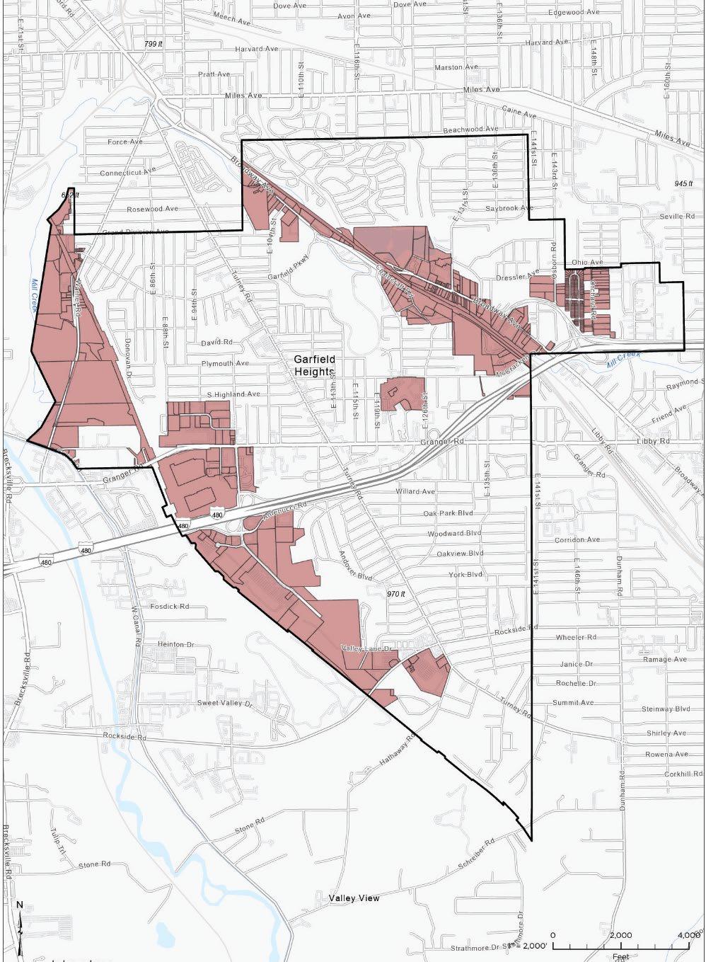
Figure 1142-01: Map of the Commercial (COM) District. Please note that this zoning map may have been modified over time, and this version may not reflect recent changes; please see the City’s website for the most current version of the zoning map.
City of Garfield Heights, Ohio, Planning and Zoning Code
>Title Two | Zoning District Standards
>>Chapter 1142: Commercial (COM) District

§1142.01 INTENT OF THE COMMERCIAL DISTRICT. The Commercial District intends to promote large-scale commercial operations that support employment, including offices, large retailers, and industrial users that may yield large volumes of passenger traffic; generate heavy truck traffic; produce noxious noise, vibrations, or air pollutants; or are otherwise incompatible with walkable residential or mixed-use neighborhoods. Certain special uses may be prohibited in the Commercial District but permitted in the Special Use District.
§1142.02 USES IN THE COMMERCIAL DISTRICT
(A) Number of Uses per Lot. More than one principal use is permitted per lot in the Commercial District.
(B) Accessory Uses. Accessory uses shall be permitted in accordance with accessory use regulations found in Chapter 1151.
(C) Uses Restricted. No building or land within the Commercial District shall be used for any purpose other than for a purpose included in the list of allowed uses below. Additional use regulations of Chapter 1150 shall apply. All use terms are defined in this Planning and Zoning Code’s Glossary in Chapter 1205. Allowed Uses in the COM District Required Approval Process Reference to Specific Regulations COMMERCIAL USES
Animal Boarding Administrative Review §1150.05
Craft and Art Industrial Administrative Review §1150.09
Emergency and In-Patient Medical Services Administrative Review §1150.11
Indoor Dining, Drinking, and Entertainment Administrative Review §1150.13
Indoor Sales and Services Administrative Review §1150.15
City of Garfield Heights, Ohio, Planning and Zoning Code
>Title Two | Zoning District Standards
>>Chapter 1142: Commercial (COM) District
Heavy Industrial Administrative Review §1150.12
Large Indoor Events Center Administrative Review §1150.16
Large Utility Administrative Review §1150.17
Light Industrial Administrative Review §1150.19
Lodging Administrative Review §1150.20
Outdoor Dining, Drinking, and Entertainment
Outdoor Sales
Conditional Use Review §1150.23
Conditional Use Review §1150.24
Outdoor Venues Administrative Review §1150.25
Vehicle Sales, Refueling, Repair, and Servicing Administrative Review §1150.33
INSTITUTIONAL USES
Indoor Recreation/Community Centers Administrative Review §1150.14
Libraries, Museums, Playhouses, and Places of Worship Administrative Review §1150.18
OPEN SPACE USES
Commercial Agriculture Administrative Review §1150.07
Preserves Administrative Review §1150.27
Sports Fields and Outdoor Recreation Administrative Review §1150.30
MISCELLANEOUS USES
Accessory Uses Administrative Review Chapter 1151
Temporary Uses Administrative Review Chapter 1152
City of Garfield Heights, Ohio, Planning and Zoning Code
>Title Two | Zoning District Standards 41
>>Chapter 1142: Commercial (COM) District
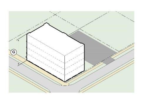
(A) No lot may be created which does not conform with the lot size standards listed below.
(B) No building shall be erected or modified unless such building or the modified portion of such building conforms with the yard setback and building scale standards listed below.
(A) Parking and Driveway Regulations. Parking and driveway regulations can be found in this Planning and Zoning Code Chapter 1155 “Parking Standards”.
(B) Fence Regulations. Fence regulations can be found in this Planning and Zoning Code Chapter 1157 “Fence Standards”.
(C) Construction Stormwater Controls Stormwater regulations for construction sites that may disturb one acre or greater, as well as other environmental standards such as hillside and floodplain protections, can be found in this Planning and Zoning Code Title Six "Environmental Regulations”.
(D) Outdoor Storage Regulations. Outdoor storage regulations can be found in this Planning and Zoning Code Chapter 1160 “Dumpsters and Outdoor Storage Standards”.
(E) Noise Regulations. Noise levels are regulated by the Noise Control chapter of the Codified Ordinances of Garfield Heights and is not included in this Planning and Zoning Code; please contact the City of Garfield Heights for details on noise control provisions.
(F) Building Code Regulations. All new buildings and modifications to buildings must adhere to the City of Garfield Heights building code. The building code is not included in this Planning and Zoning Code; please contact the City of Garfield Heights Building Department for details on conforming to the building code.
City of Garfield Heights, Ohio, Planning and Zoning Code >Title Two | Zoning District Standards
>>Chapter 1142: Commercial (COM) District
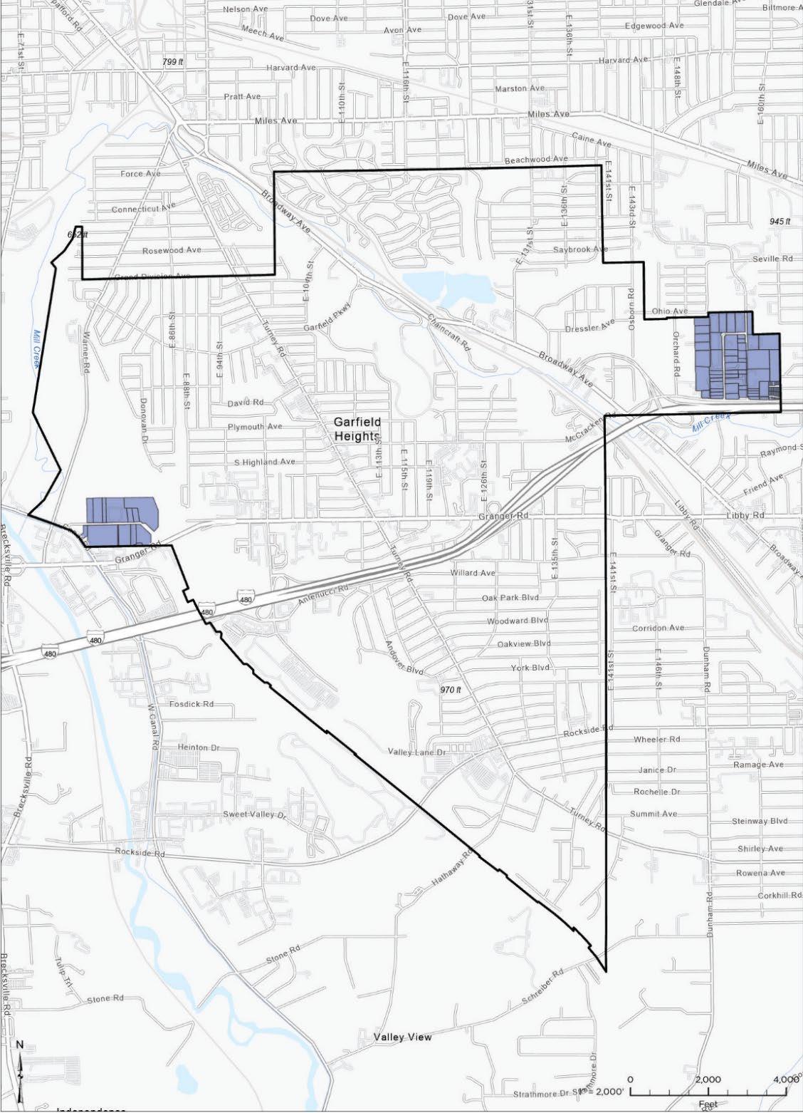
Figure 1143-01: Map of the Special Use (SPCL) District. Please note that this zoning map may have been modified over time, and this version may not reflect recent changes; please see the City’s website for the most current version of the zoning map.
City of Garfield Heights, Ohio, Planning and Zoning Code
>Title Two | Zoning District Standards
>>Chapter 1143: Special Use (SPCL) District
§1143.01 INTENT OF THE SPECIAL USE DISTRICT. The Special Use District intends to promote large-scale commercial operations that support employment, including offices, large retailers, and industrial users that may yield large volumes of passenger traffic; generate heavy truck traffic; produce noxious noise, vibrations, or air pollutants; or are otherwise incompatible with walkable residential or mixed-use neighborhoods. The Special Use District intends to provide opportunities for certain special uses, such as sexually oriented businesses, where such uses have the potential to adversely impact the character of other districts.
§1143.02 USES IN THE SPECIAL USE DISTRICT
(A) Number of Uses per Lot. More than one principal use is permitted per lot in the Special Use District.
(B) Accessory Uses. Accessory uses shall be permitted in accordance with accessory use regulations found in Chapter 1151.
(C) Uses Restricted. No building or land within the Special Use District shall be used for any purpose other than for a purpose included in the list of allowed uses below. Additional use regulations of Chapter 1150 shall apply. All use terms are defined in this Planning and Zoning Code’s Glossary in Chapter 1205.
City of Garfield Heights, Ohio, Planning and Zoning Code
>Title Two | Zoning District Standards
>>Chapter 1143: Special Use (SPCL) District
Indoor Sales and Services
Heavy Industrial
Large Utility
Light Industrial
Marijuana-, Vape-, or SmokeOriented Uses
Outdoor Dining, Drinking, and Entertainment
Outdoor Venues
Pawn Shops
Vehicle Sales, Refueling, Repair, and Servicing
Vehicle Storage
Weapons-Oriented Uses
INSTITUTIONAL USES
Indoor Recreation/Community Centers
Libraries, Museums, Playhouses, and Places of Worship
OPEN SPACE USES Commercial
MISCELLANEOUS USES
Accessory Uses
Review
1151 Temporary Uses
City of Garfield Heights, Ohio, Planning and Zoning Code
>Title Two | Zoning District Standards
>>Chapter 1143: Special Use (SPCL) District
>>Chapter 1143: Special Use (SPCL) District §1143.03
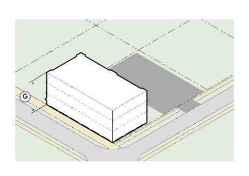
(A) No lot may be created which does not conform with the lot size standards listed below.
(B) No building shall be erected or modified unless such building or the modified portion of such building conforms with the yard setback and building scale standards listed below.
(A) Parking and Driveway Regulations. Parking and driveway regulations can be found in this Planning and Zoning Code Chapter 1155 “Parking Standards”.
(B) Fence Regulations. Fence regulations can be found in this Planning and Zoning Code Chapter 1157 “Fence Standards”.
(C) Construction Stormwater Controls Stormwater regulations for construction sites that may disturb one acre or greater, as well as other environmental standards such as hillside and floodplain protections, can be found in this Planning and Zoning Code Title Six "Environmental Regulations”.
(D) Outdoor Storage Regulations. Outdoor storage regulations can be found in this Planning and Zoning Code Chapter 1160 “Dumpsters and Outdoor Storage Standards”.
(E) Noise Regulations. Noise levels are regulated by the Noise Control chapter of the Codified Ordinances of Garfield Heights and is not included in this Planning and Zoning Code; please contact the City of Garfield Heights for details on noise control provisions.
(F) Building Code Regulations. All new buildings and modifications to buildings must adhere to the City of Garfield Heights building code. The building code is not included in this Planning and Zoning Code; please contact the City of Garfield Heights Building Department for details on conforming to the building code.
City of Garfield Heights, Ohio, Planning and Zoning Code
>Title Two | Zoning District Standards
>>Chapter 1143: Special Use (SPCL) District
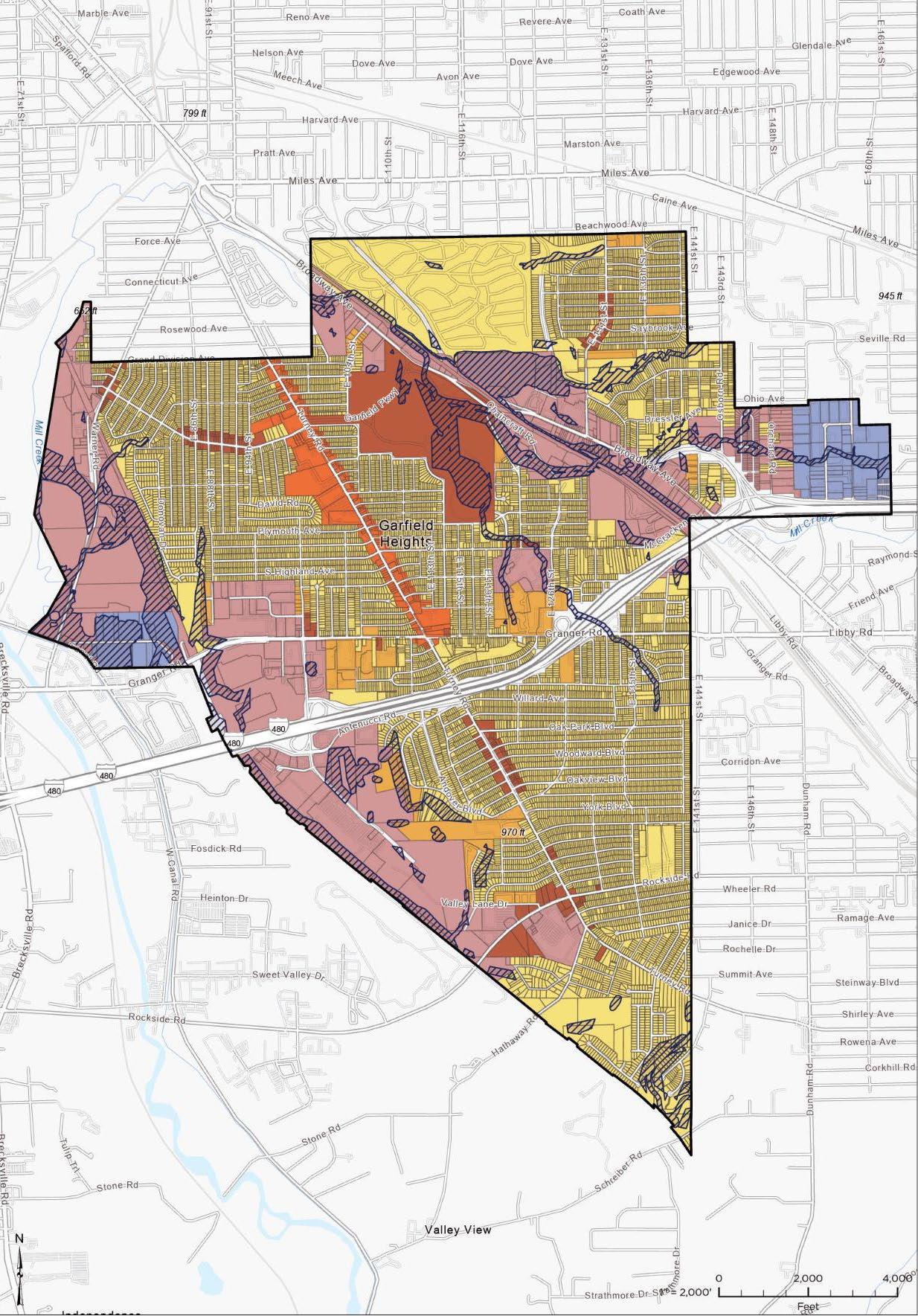
Figure 1144-01: Map of the Environmentally Sensitive Overlay (ENV-O) District, shown with diagonal lines. Please note that this zoning map may have been modified over time, and this version may not reflect recent changes; please see the City’s website for the most current version of the zoning map.
City of Garfield Heights, Ohio, Planning and Zoning Code
>Title Two | Zoning District Standards
>>Chapter 1144: Environmentally Sensitive Overlay (ENV-O) District
§1144.01 INTENT OF THE ENVIRONMENTALLY SENSITIVE OVERLAY DISTRICT. The Environmentally Sensitive Overlay District intends to limit the negative impacts of development and land use on sensitive environmental resources, as espoused by the 2022 Community Master Plan, by applying more restrictive development and land use standards in areas close to such sensitive resources
§1144.02 APPLICABILITY OF THE STANDARDS OF THE ENVIRONMENTALLY SENSITIVE OVERLAY DISTRICT
(A) The standards of the Environmentally Sensitive Overlay District shall apply to all portions of lots, all portions of buildings, and all land uses conducted on such portions of lots or buildings within the area of applicability, as described below. Some of the standards of the Environmentally Sensitive Overlay District may be stricter than the standards of the underlying base zoning district; in such cases, the stricter standards shall apply. Where the Environmentally Sensitive Overlay District does not include standards, such as for building height, the standards of the underlying base zoning district shall apply.
(B) The area of applicability of the Environmentally Sensitive Overlay District comprises all areas that meet the criteria below:
(i) Areas within 50 feet of a wetland, measured horizontally, as on a plan view map;
(ii) Areas within a floodplain; and
(iii) Areas of steep slopes, defined as areas of 15% slope or greater
(C) Wetlands shall be defined as per the definition by the Ohio Environmental Protection Agency. Wetland shall include all areas demarcated as any type of wetland by the US Fish and Wildlife Service’s online Wetlands Mapper tool, including riverine wetlands such as streams and creeks. These areas shall also be shown on the official zoning map as part of the Environmentally Sensitive Overlay District.
(D) Floodplains shall be interpreted all areas demarcated as any type of floodplain by the Federal Emergency Management Agency (FEMA) on an official Flood Insurance Rate Map (FIRM), FIRMette, or the FEMA National Flood Hazard Layer Viewer online tool. These areas shall also be shown on the official zoning map as part of the Environmentally Sensitive Overlay District.
(E) Slope percentages shall be interpreted as the number of feet of vertical rise divided by the number of feet of horizontal run, multiplied by 100. These areas shall be shown on the official zoning map as part of the Environmentally Sensitive Overlay District.
(F) The area of applicability of the Environmentally Sensitive Overlay District is approximately mapped on the official zoning map, found on the City’s website. However, the area shown on the map shall be interpreted as illustrative only, as floodplains and wetlands may change in their boundaries over time, and the official zoning map may not reflect the most current boundaries. The user of this code should consult the US Fish and Wildlife Service’s online Wetlands Mapper tool and the Federal Emergency Management Agency’s National Flood Hazard Layer Viewer online tool for current wetland and floodplain boundaries
City of Garfield Heights, Ohio, Planning and Zoning Code >Title Two | Zoning District Standards
>>Chapter 1144: Environmentally Sensitive
(ENV-O) District
(A) No building, portion of a building, or any other structure shall be built within the Environmentally Sensitive Overlay District, except that recreational area amenities, such as benches or permanent picnic tables, may be installed where issued written permission by the City of Garfield Heights Planning Commission Any portion of a structure within the Environmentally Sensitive Overlay District that was lawfully erected prior to the enactment of this Planning and Zoning Code may be repaired or maintained, provided that the footprint of such portion of the structure within the Environmentally Sensitive Overlay District is not expanded
(B) No impervious surface, such as and including paved parking lot area, shall be installed within the Environmentally Sensitive Overlay District, except that a paved driveway or recreational trail may be installed where issued written permission by the City of Garfield Heights Planning Commission.
§1144.04
(A) No tree clearing may occur within the Environmentally Sensitive Overlay District, except in the following circumstances:
(i) Where tree clearing is required to maintain a utility right-of-way per US Department of Transportation standards;
(ii) Where tree clearing is required to protect the public health and safety, such as clearing snags within 100 feet of an inhabited structure; or
(iii) Where tree clearing is used to remove invasive tree species and is coupled with the replacement of such cleared trees with native plant species
(B) Tree clearing, for the above regulation, shall be interpreted to mean the removal of any tree of over three inches trunk diameter, measured at four feet of height
(C) No use of herbicides shall occur within the Environmentally Sensitive Overlay District, except where the use of herbicides is targeted at the elimination of invasive plant species and is coupled with the installation of native plant species.
§1144.05 OTHER STANDARDS APPLICABLE TO THE ENVIRONMENTALLY SENSITIVE OVERLAY DISTRICT
(A) If your property is within or near the Environmentally Sensitive Overlay District, please refer to Title Six "Environmental Regulations” of this Planning and Zoning Code, as your property may be subject to additional requirements for riparian setbacks, hillside protections, floodplain protections, etc.
City of Garfield Heights, Ohio, Planning and Zoning Code >Title Two | Zoning District Standards
>>Chapter 1144: Environmentally Sensitive Overlay (ENV-O) District
This chapter’s regulations are intended to reduce the effects that certain land uses may have on the public’s health, safety, and welfare by restricting the use of land district-by-district within the city.
This Code restricts the use of land in two manners: (1) by restricting the use of land within each district to only those land uses expressly allowed in that district and (2) by restricting the use of land by use-specific standards, as described later in this Title.
No lot, structure, or portion thereof may be used for any purpose, except as expressly allowed in that district by this Title.
§1148.01 LAND USE TERMS DEFINED. Land use terms listed in this Planning and Zoning Code are defined in Title Nine "Glossary of Terms”
§1148.02 INTERPRETATION AND APPLICATION OF LAND USES BY BUILDING COMMISSIONER AND ECONOMIC DEVELOPMENT DIRECTOR. As this Code cannot conceive of every proposed land use in the city, it uses general land use terms and defines these terms in this Title Nine "Glossary of Terms”. The Building Commissioner and Economic Development Director or their designees shall be responsible for analyzing real or proposed land uses and assigning them to one of the listed general land use terms, or a combination of multiple listed general land use terms, or none of the listed general land use terms, based on their professional interpretation of the real or proposed land use and the general land use term’s definition.
§1148.03 LAND USES NOT MATCHING ANY LISTED LAND USE TERM. In some cases, the Building Commissioner and Economic Development Director or their designees may determine that the real or proposed land use does not meet the definitions of any of the defined general land use terms, and, in such case, the Director of Planning and Development or their designee shall determine that such land use is prohibited in all districts in the city, except where allowed by nonconforming use regulations found in Title Eight "Nonconformities”.
§1148.04 PROPOSED LAND USES FITTING MORE THAN ONE LAND USE TERM. Wherever the proposed use of a lot fits the definition of more than one land use term and where at least one of those land use terms is an allowed land use in that district, such proposed use shall be allowed.
City of Garfield Heights, Ohio, Planning and Zoning Code
>Title Three | Land Use Standards 52
>>Chapter 1145: Purpose of Land Use Standards Chapter
§1148.05 PROPOSED LAND USES COMPRISE MULTIPLE LAND USES Wherever the proposed use of a lot comprises multiple land uses, each and every land use shall be permitted in that district in order for the multiple land uses to be permitted. For example, where a hotel with first-floor bar are proposed, both a hotel use and a bar use must be permitted in that district; if the district only allows a hotel use and does not allow a bar use, the proposed hotel and bar use shall not be permitted, and, to receive the proper permits, the applicant may choose to amend the proposal to include a hotel only without a first-floor bar. Where this Planning and Zoning Code does not contain clarity in its land use definitions on whether all of the proposed uses are included within the list of permitted uses for that district, the Building Commissioner and Economic Development Director or their designees shall make a determination as to whether the proposed uses are customarily included in the definitions of permitted uses for that district.
§1148.06 APPEAL OF INTERPRETATION OF LAND USES. Where an affected party believes that the interpretation of the real or proposed land use by the Building Commissioner and Economic Development Director or their designees as falling into one, more than one, or zero general land use terms was made in error, such party may appeal such interpretation. The appeal process is described in detail in Chapter 1190 “Appeals.”
§1149.01 TABLE OF ALLOWED LAND USES. Land uses are listed in the Table of Allowed Land Uses as “Administrative Review” and “Conditional Use Review.” “Administrative Review” and “Conditional Use Review” uses are principal uses and refer to two different approval processes, as described in Title Seven "Administration and Procedures”.
(A) Where a proposed land use is not listed as “Administrative Review,” “Conditional Use Review,” or “Accessory” in a particular district, such proposed land use shall be interpreted to be prohibited in that district, unless the proposed land use is interpreted by the Building Commissioner and Economic Development Director or their designees as being defined by more than one land use term and at least one of those land use terms is allowed in that district.
(B) Shall any inconsistency exist between the list of uses allowed in a district in the districtspecific chapter of Title Two "Zoning District Standards” and the table of allowed land uses of this Title, the table of allowed land uses of this Title shall govern.
Table of Allowed Land Uses
USES
City of Garfield Heights, Ohio, Planning and Zoning Code
>Title Three | Land Use Standards 53
>>Chapter 1149: Allowed Land Uses
1149-01: Table of Allowed
= Administrative Review CUR = Conditional Use Review * = This land use is permitted only where permitted in the underlying, base district.
§1150.01 CONFORMANCE WITH USE-SPECIFIC REGULATIONS REQUIRED. No use shall be conducted except where conforming to all of the standards contained in this Chapter or where otherwise permitted by Title Eight "Nonconformities”.
§1150.02 3-8-UNIT RESIDENTIAL
(A) Definition. The definition of this land use can be found in Title Nine "Glossary of Terms” of this Planning and Zoning Code.
(B) Use-Specific Standards. This Planning and Zoning Code does not contain standards specific to this land use; however, please note that this Planning and Zoning Code’s district-specific standards, sign standards, and generally applicable standards shall apply to this land use , and please note that the Building Code standards shall apply to this land use.
(C) Accessory Use Standards. For details on accessory uses associated with this land use, such as home occupations, please refer to Chapter 1151 “Accessory Use and Structure Regulations.”
of Garfield Heights, Ohio, Planning and Zoning Code
(D) Cottage Court Standards. For details on the development of cottage courts, which, for the purposes of this Code are considered Cottage Court Residential uses and not 3-8Unit Residential uses, please refer to §1150.08 “Cottage Court Residential”
(E) Townhouse Standards. For details on the development of townhouses, which, for the purposes of this Code are considered Townhouse Residential uses and not 3-8-Unit Residential uses, please refer to §1150.31“Townhouse Residential”
§1150.03 9-PLUS-UNIT RESIDENTIAL
(A) Definition. The definition of this land use can be found in Title Nine "Glossary of Terms” of this Planning and Zoning Code.
(B) Use-Specific Standards. This Planning and Zoning Code does not contain standards specific to this land use; however, please note that this Planning and Zoning Code’s district-specific standards, sign standards, and generally applicable standards shall apply to this land use, and please note that the Building Code standards shall apply to this land use.
(C) Accessory Use Standards. For details on accessory uses associated with this land use, such as home occupations, please refer to Chapter 1151 “Accessory Use and Structure Regulations.”
(D) Cottage Court Standards. For details on the development of cottage courts, which, for the purposes of this Code are considered Cottage Court Residential uses and not 9-PlusUnit Residential uses, please refer to §1150.08 “Cottage Court Residential”.
§1150.04
(A) Definition. The definition of this land use can be found in Title Nine "Glossary of Terms” of this Planning and Zoning Code.
(B) Use-Specific Standards
(i) Purpose. It is the purpose of this Section to regulate sexually oriented businesses in order to promote the health, safety, morals, and general welfare of the citizens of the City, and to establish reasonable and uniform regulations to prevent the deleterious location and concentration of sexually oriented businesses within the City. The provisions of this Section do not have the purpose or effect of imposing a limitation or restriction on the content of any communicative materials, including sexually oriented materials. Further, it is not the intent of this Section to restrict or deny access by adults to sexually oriented materials protected by the First Amendment, or to deny access by the distributors and exhibitors of sexually oriented entertainment to their intended market. Neither is it the intent nor effect of this chapter to condone or legitimize the distribution of obscene material.
(ii) Findings. The City Council has received substantial evidence concerning the association of negative secondary effects with sexually oriented businesses in the cases of City of Renton v. Playtime Theatres, Inc., 475 U.S. 41 (1986), Young
City of Garfield Heights, Ohio, Planning and Zoning Code
>Title Three | Land Use Standards 56
>>Chapter 1150: Use-Specific Regulations for Principal Uses
v. American Mini Theatres, 426 U.S. 50 (1976), and Barnes v. Glen Theatre, Inc., 501 U.S. 560 (1991), and on studies in other communities including, but not limited to, Phoenix, Arizona; Tucson, Arizona; Los Angeles, California; Whittier, California; Indianapolis, Indiana; Minneapolis, Minnesota; St. Paul, Minnesota; New York, New York; Cleveland, Ohio; Oklahoma City, Oklahoma; Amarillo, Texas; Austin, Texas; Beaumont, Texas; Houston, Texas; and Seattle, Washington.
(iii) Location. No Adult-Oriented Uses may be located, established or operated on any lot located south of the centerline of Granger Road. Furthermore, no AdultOriented Uses may be established or operated within 300 feet of:
(1) A church, synagogue, mosque, temple or other building which is used primarily for religious worship and related religious activities;
(2) A public or private educational facility that serves persons younger than 18 years of age, including but not limited to nursery schools, preschools, kindergartens, elementary schools, private schools, intermediate schools, junior high schools, middle schools, high schools, vocational schools, secondary schools, continuation schools, special education schools, junior colleges, and universities; school includes the school grounds, but does not include facilities used primarily for another purpose and only incidentally as a school;
(3) Any property containing a community center that regularly serves persons younger than 18 years of age;
(4) A public park or recreational area which has been designated for park or recreational activities including but not limited to a park, playground, nature trails, swimming pool, athletic field, basketball or tennis courts, pedestrian/bicycle paths, wilderness areas, or other similar public land within the City which is under the control, operation, or management of the City, the Garfield Heights Board of Education, Cleveland Metroparks, or another public entity;
(5) A public library or museum that regularly serves persons younger than 18 years of age;
(6) Any lot in a residential district as defined in the Planning and Zoning Code or any lot occupied by a dwelling that constitutes a lawful nonconforming residential use as defined in the Planning and Zoning Code.
(iv) No Adult-Oriented Use may be established or operated within 500 feet of another Adult-Oriented Use.
(v) Not more than one Adult-Oriented Use shall be established or operated in the same building, structure, or portion thereof, and the floor area of any AdultOriented Use in any building, structure, or portion thereof containing another Adult-Oriented Use may not be substantially enlarged.
(vi) No such use shall be issued a Zoning Permit by the Building Commissioner or be permitted to commence except following review and written authorization of the City Council. In reviewing a proposed use, the Planning Commission, the Zoning Board of Appeals, and the City Council shall consider the use’s vicinity to existing and planned schools, daycare facilities, playgrounds, libraries, parks,
City of Garfield Heights, Ohio, Planning and Zoning Code
>Title Three | Land Use Standards 57
>>Chapter 1150: Use-Specific Regulations for Principal Uses
recreational fields, and places of worship; the use’s vicinity to existing or planned Adult-Oriented Uses, Bail Bond Lending Uses, Pawn Shops, Marijuana-, Vape-, or Smoke-Oriented Uses, Weapons-Oriented Uses, and Vehicle Storage Uses; the use’s vicinity to governmental offices; and the use’s vicinity to existing or planned residential and institutional properties.
(vii) For the purpose of this Section, measurement shall be made in a straight line without regard to intervening structures or natural features from the nearest portion of the property line of the lot occupied by an Adult-Oriented Use to the nearest property line of any other use listed.
(A) Definition. The definition of this land use can be found in Title Nine "Glossary of Terms” of this Planning and Zoning Code.
(B) Use-Specific Standards. This Planning and Zoning Code does not contain standards specific to this land use; however, please note that this Planning and Zoning Code’s district-specific standards, sign standards, and generally applicable standards shall apply to this land use, and please note that the Building Code standards shall apply to this land use.
(A) Definition. The definition of this land use can be found in Title Nine "Glossary of Terms” of this Planning and Zoning Code.
(B) Use-Specific Standards. No such use shall be issued a Zoning Permit by the Building Commissioner or be permitted to commence except following review and written authorization of the City Council. In reviewing a proposed use, the Planning Commission, the Zoning Board of Appeals, and the City Council shall consider the use’s vicinity to existing and planned schools, daycare facilities, playgrounds, libraries, parks, recreational fields, and places of worship; the use’s vicinity to existing or planned Adult-Oriented Uses, Bail Bond Lending Uses, Pawn Shops, Marijuana-, Vape-, or Smoke-Oriented Uses, Weapons-Oriented Uses, and Vehicle Storage Uses; the use’s vicinity to governmental offices; and the use’s vicinity to existing or planned residential and institutional properties.
(A) Definition. The definition of this land use can be found in Title Nine "Glossary of Terms” of this Planning and Zoning Code.
(B) Use-Specific Standards. No Commercial Agriculture use shall be conducted except where it satisfies all of the following conditions:
(i) The Commercial Agriculture use is located on a lot of greater than one acre and on a lot that is not part of a platted subdivision.
City of Garfield Heights, Ohio, Planning and Zoning Code
>Title Three | Land Use Standards 58
>>Chapter 1150: Use-Specific Regulations for Principal Uses
(ii) Tilled or planted crop areas or areas where animals are contained shall be set back at least 50 feet from abutting residential and at least 50 feet from any public right-of-way.
(iii) Structures shall only be permitted on lots of five acres or greater and shall be limited to (i) one building for storage of equipment and materials used in the agricultural activity and/or for the keeping of animals set back at least 100 feet from side and rear lot lines, with a maximum building floor area of 4,000 square feet; (ii) one farm stand set back at least 50 feet from the public rightof-way and set back at least 100 feet from side and rear lot lines and occupying a maximum of 200 square feet; and (iii) greenhouses, hoop houses, and/or high tunnels that are set back at least 100 feet from the public right-of-way and at least 100 feet from side and rear lot lines.
(iv) On-site sales shall be limited to products grown entirely on the lot and may only be conducted in a farm stand or within other permitted structures.
(A) Definition. The definition of this land use can be found in Title Nine "Glossary of Terms” of this Planning and Zoning Code.
(B) Use-Specific Standards
(i) Applicability. These cottage court standards shall apply to any development that fits the definition of Cottage Court Residential, as defined by this Code.
(ii) Ownership Model of Cottage Courts. Cottage courts may be organized in one of the following ownership models:
(1) All Units on One Lot. In this ownership model, all of the housing units, all common area, and all parking is located on one lot and has one owner. Typically, this ownership model is employed where the units of the cottage court are renter-occupied. In this case, any code violations can be directed to the landlord.
(2) Condominium. In this ownership model, the housing units themselves are condominiums and are individually owned. However, all of the land, including the land under the condominiums, is communally owned by a condominium association. The owners of the individual condominiums are members of the condominium association and make decisions according to their bylaws. In this case, any code violations for building maintenance of individual units can be directed to the unit’s owner, and any code violations for landscaping or other land-related regulations can be directed to the condominium association.
City of Garfield Heights, Ohio, Planning and Zoning Code
>Title Three | Land Use Standards 59
>>Chapter 1150: Use-Specific Regulations for Principal Uses
(3) Landominium. In this ownership model, the housing units themselves and the land under the housing units and sometimes additional buffer of land around each of the units are individually owned. Other land, including a common green space, buffer area, utility or garbage storage areas, etc., are owned by a condominium association. The owners of the individual housing units are members of the condominium association and make decisions according to their bylaws. In this case, any code violations for building maintenance of individual units or the land owned by the owners of such individual units can be directed to the unit’s owner, and any code violations for landscaping or other land-related regulations on communal land can be directed to the condominium association.
(4) Private Land with Access Easements. In this ownership model, there is no communally owned land. Each housing unit is individually owned, and each housing unit owner also owns the land under the unit and surrounding the unit. One landowner’s property extends all the way to the neighbor’s property. The lot lines extend all the way to the center of the communal foot path, and an access easement is granted along the portion of each lot that contains the communal footpath. Any code violation can be directed to the owner of land on which the violation has occurred.
(iii) Lot Area and Lot Width for Cottage Court Dwellings. Land intended for development into a cottage court dwelling with a landominium ownership model is exempt from the lot area requirements of the district in which they are located; however, the collective area of all lots in the cottage court development and all homeowners association-owned land must add up to at least 2,200 square feet per dwelling unit.

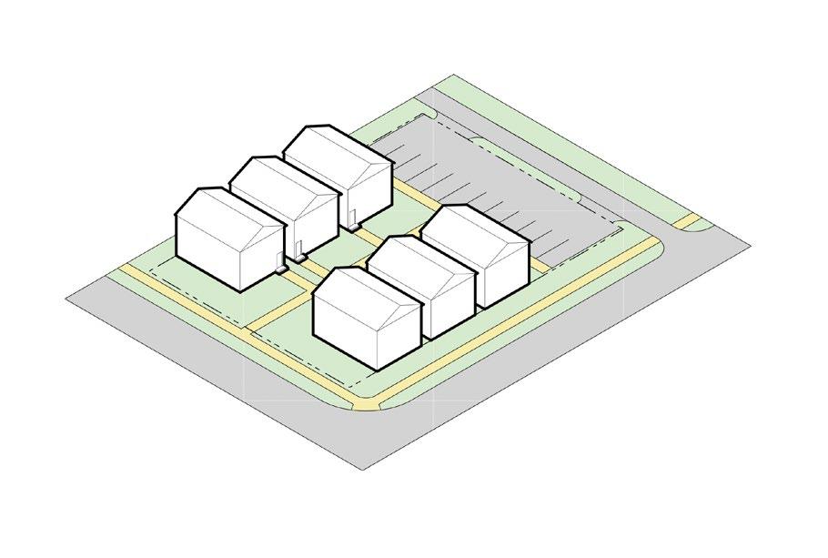
(iv) Cottage Court Standards. No dwelling unit within the cottage court shall be developed except where such dwelling unit satisfies all of the following conditions:
(1) The dwelling unit is contained within a detached structure and is not considered a duplex or other multi-family structure;
(2) The dwelling unit contains a front porch of at least 80 square feet; the front porch shall be oriented towards the common open space;
(3) The dwelling unit does not exceed 850 square feet; the open front porch shall not contribute to the total square footage of the dwelling unit; and
(4) The dwelling unit’s exterior walls shall maintain a separation from the external walls of all other dwelling units within the cottage court of at least twice the required side setback in the district in which it is located. For example, if, in the Residential 1 District, the side yard setback is 5 feet minimum, no cottage court in the Residential 1 District shall have dwelling units that have a separation of less than 10 feet.
(v) Plan Required. No cottage court shall be permitted except where an application for such use contains a to-scale plan illustrating (1) the location of each cottage site, (2) interior circulation, (3) access to public rights-of-way, (4) screening, (5) solid waste storage and removal areas, and (6) emergency fireresponse fire lanes and fire hydrant locations.
(vi) Emergency Response for Cottage Courts. No cottage court shall be permitted except where each dwelling unit within the cottage court is adequately accessible to public emergency response, including fire response, medical response, and law enforcement response; any application for a zoning permit for a cottage court shall be subject to review and approval by the City.
(vii) Water and Sewerage. No cottage court shall be permitted except where each dwelling unit within the cottage court is connected to a public water supply. No cottage court shall be permitted except where each dwelling unit within the cottage court is connected to public sewerage; public sewerage, for the purposes of this provision, may include a County Health Department-approved communal septic processing facility.
(C) Accessory Use Standards. For details on accessory uses associated with this land use, such as home occupations, please refer to Chapter 1151 “Accessory Use and Structure Regulations.”
(A) Definition. The definition of this land use can be found in Title Nine "Glossary of Terms” of this Planning and Zoning Code.
(B) Use-Specific Standards. This Planning and Zoning Code does not contain standards specific to this land use; however, please note that this Planning and Zoning Code’s district-specific standards, sign standards, and generally applicable standards shall
City of Garfield Heights, Ohio, Planning and Zoning Code
>Title Three | Land Use Standards
>>Chapter 1150: Use-Specific Regulations for Principal Uses
apply to this land use, and please note that the Building Code standards shall apply to this land use.
(A) Definition. The definition of this land use can be found in Title Nine "Glossary of Terms” of this Planning and Zoning Code.
(B) Use-Specific Standards. This Planning and Zoning Code does not contain standards specific to this land use; however, please note that this Planning and Zoning Code’s district-specific standards, sign standards, and generally applicable standards shall apply to this land use, and please note that the Building Code standards shall apply to this land use.
(A) Definition. The definition of this land use can be found in Title Nine "Glossary of Terms” of this Planning and Zoning Code.
(B) Use-Specific Standards. No Emergency and In-Patient Medical Services use shall be conducted except where all of the following conditions are satisfied:
(i) The Emergency and In-Patient Medical Services uses, where a helipad is used, provides a minimum of 500 feet (as measured on a direct path) of separation between the edge of the helipad and any structure containing or arranged to contain a residential use.
(ii) Protected pedestrian-ways shall be provided to connect the public sidewalk network to the main entrance of the building. Protected pedestrian-ways shall be provided within or alongside all parking areas and shall connect each parking space with the entrance of the building. All protected pedestrian-ways shall be traversable by wheelchairs and shall be adequately maintained by clearing all debris and snow to ensure continuous safe use by persons with disabilities.
(iii) Biohazardous waste and biomedical waste shall be appropriately isolated from the general solid waste stream, appropriately stored, and hauled off site by a licensed biohazard handling company.
§1150.12
(A) Definition. The definition of this land use can be found in Title Nine "Glossary of Terms” of this Planning and Zoning Code.
(B) Use-Specific Standards. This Planning and Zoning Code does not contain standards specific to this land use; however, please note that this Planning and Zoning Code’s district-specific standards, sign standards, and generally applicable standards shall apply to this land use, and please note that the Building Code standards shall apply to this land use.
§1150.13
City of Garfield Heights, Ohio, Planning and Zoning Code
>Title Three | Land Use Standards 62
>>Chapter 1150: Use-Specific Regulations for Principal Uses
§1150.14
(A) Definition. The definition of this land use can be found in Title Nine "Glossary of Terms” of this Planning and Zoning Code.
(B) Use-Specific Standards. This Planning and Zoning Code does not contain standards specific to this land use; however, please note that this Planning and Zoning Code’s district-specific standards, sign standards, and generally applicable standards shall apply to this land use, and please note that the Building Code standards shall apply to this land use.
(A) Definition. The definition of this land use can be found in Title Nine "Glossary of Terms” of this Planning and Zoning Code.
(B) Use-Specific Standards. This Planning and Zoning Code does not contain standards specific to this land use; however, please note that this Planning and Zoning Code’s district-specific standards, sign standards, and generally applicable standards shall apply to this land use, and please note that the Building Code standards shall apply to this land use.
§1150.15
(A) Definition. The definition of this land use can be found in Title Nine "Glossary of Terms” of this Planning and Zoning Code.
(B) Use-Specific Standards. This Planning and Zoning Code does not contain standards specific to this land use; however, please note that this Planning and Zoning Code’s district-specific standards, sign standards, and generally applicable standards shall apply to this land use, and please note that the Building Code standards shall apply to this land use.
§1150.16
(A) Definition. The definition of this land use can be found in Title Nine "Glossary of Terms” of this Planning and Zoning Code.
(B) Use-Specific Standards. No Large Indoor Events Center shall be constructed except on a lot within the Commercial District or on a lot of greater than one acre in any other district.
§1150.17
(A) Definition. The definition of this land use can be found in Title Nine "Glossary of Terms” of this Planning and Zoning Code.
(B) Use-Specific Standards
(i) Large utility uses shall be completely surrounded by an opaque fence of at least 8 feet in height; please note that, where this use is conducted in a district that
City of Garfield Heights, Ohio, Planning and Zoning Code
>Title Three | Land Use Standards
>>Chapter 1150: Use-Specific Regulations for Principal Uses
§1150.18
§1150.19
§1150.20
does not generally permit an 8-foot-high fence, this provision shall be interpreted as overriding such district-specific limits on fence height.
(ii) Any structure associated with a large utility use, such as piping, pump houses, electrical substation converters or inverters, shall be distanced from any adjacent lot that permits residential uses by at least 50 feet; please note that other regulations, such as the building code, health code, state code, or federal code, may require greater separation from residential land uses than this provision.
(iii) No wind turbine shall be erected except where its base is set back from all lot lines by a distance equal to its height, where the height of a wind turbine shall be measured from the ground elevation to the highest reach of any of its blades.
(iv) No wind turbine shall impair the safe operation of aircraft, as determined by the Federal Aviation Administration.
(v) For wireless telecommunications towers, antennae, shelters, and facilities, refer to regulations in Chapter 1154 “Wireless Telecommunications Towers and Facilities” of this Planning and Zoning Code.
(A) Definition. The definition of this land use can be found in Title Nine "Glossary of Terms” of this Planning and Zoning Code.
(B) Use-Specific Standards. This Planning and Zoning Code does not contain standards specific to this land use; however, please note that this Planning and Zoning Code’s district-specific standards, sign standards, and generally applicable standards shall apply to this land use, and please note that the Building Code standards shall apply to this land use.
(A) Definition. The definition of this land use can be found in Title Nine "Glossary of Terms” of this Planning and Zoning Code.
(B) Use-Specific Standards
(i) No Light Industrial use shall emit fumes, odors, vibrations, dust, or other effects that may pose a threat to the safety or health of land users on adjacent lots, or that may damage the integrity of structures on adjacent lots.
(ii) Biohazardous waste and biomedical waste shall be appropriately isolated from the general solid waste stream, appropriately stored, and hauled off site by a company licensed to handle biohazardous waste.
(A) Definition. The definition of this land use can be found in Title Nine "Glossary of Terms” of this Planning and Zoning Code.
City of Garfield Heights, Ohio, Planning and Zoning Code
>Title Three | Land Use Standards 64
>>Chapter 1150: Use-Specific Regulations for Principal Uses
(B) Use-Specific Standards. This Planning and Zoning Code does not contain standards specific to this land use; however, please note that this Planning and Zoning Code’s district-specific standards, sign standards, and generally applicable standards shall apply to this land use, and please note that the Building Code standards shall apply to this land use.
(A) Definition. The definition of this land use can be found in Title Nine "Glossary of Terms” of this Planning and Zoning Code.
(B) Use-Specific Standards
(i) No marijuana-oriented use shall operate except in conformity with State standards as administered by the Ohio Department of Commerce, Division of Cannabis Control.
(ii) No use, whether defined as a Marijuana-, Vape-, or Smoke-Oriented Use or as another use term, shall permit the emission of tobacco, marijuana, or vape smoke that may cause a health hazard to the occupants of adjacent properties, such as second-hand tobacco or marijuana smoke.
(iii) No such establishment may be located within 1,000 feet of any existing smoke shop or tobacco store, measured in a straight line from building entrance to building entrance. Additionally, no such establishment may be located within 600 feet of a public or private park, playground, or school, measured in a straight line from building entrance to nearest property line.
(iv) No such use shall be issued a Zoning Permit by the Building Commissioner or be permitted to commence except following review and written authorization of the City Council. In reviewing a proposed use, the Planning Commission, the Zoning Board of Appeals, and the City Council shall consider the use’s vicinity to existing and planned schools, daycare facilities, playgrounds, libraries, parks, recreational fields, and places of worship; the use’s vicinity to existing or planned Adult-Oriented Uses, Bail Bond Lending Uses, Pawn Shops, Marijuana-, Vape-, or Smoke-Oriented Uses, Weapons-Oriented Uses, and Vehicle Storage Uses; the use’s vicinity to governmental offices; and the use’s vicinity to existing or planned residential and institutional properties.
(A) Definition. The definition of this land use can be found in Title Nine "Glossary of Terms” of this Planning and Zoning Code.
(B) Use-Specific Standards. This Planning and Zoning Code does not contain standards specific to this land use; however, please note that this Planning and Zoning Code’s district-specific standards, sign standards, and generally applicable standards shall apply to this land use, and please note that the Building Code standards shall apply to this land use.
City of Garfield Heights, Ohio, Planning and Zoning Code
>Title Three | Land Use Standards 65
>>Chapter 1150: Use-Specific Regulations for Principal Uses
(C) Accessory Use Standards. For details on accessory uses associated with this land use, such as home occupations, please refer to Chapter 1151 “Accessory Use and Structure Regulations.”
(A) Definition. The definition of this land use can be found in Title Nine "Glossary of Terms” of this Planning and Zoning Code.
(B) Use-Specific Standards
(i) No Outdoor Dining, Drinking, and Entertainment use shall be conducted during hours prohibited by the conditional use approval granted by the Board of Zoning Appeals.
(ii) No Outdoor Dining, Drinking, and Entertainment use shall utilize sound amplification unless specifically permitted per the conditional use approval granted by the Board of Zoning Appeals.
(iii) No Outdoor Dining, Drinking, and Entertainment use shall allow for the emission of smoke, including cigarette smoke, that may jeopardize the health of neighboring occupants.
(iv) Please note additional noise control regulations in Chapter 535 of the City of Garfield Heights’s Codified Ordinances.
§1150.24
(A) Definition. The definition of this land use can be found in Title Nine "Glossary of Terms” of this Planning and Zoning Code.
(B) Use-Specific Standards. The outdoor display of commercial equipment, materials, or products for sale or rent is prohibited, unless the outdoor display is set back from the front lot line(s) a distance equal to the minimum front yard setback required for that district. Any sign that is part of an outdoor display shall comply with Title Five "Sign Regulations”.
§1150.25
(A) Definition. The definition of this land use can be found in Title Nine "Glossary of Terms” of this Planning and Zoning Code.
(B) Use-Specific Standards. This Planning and Zoning Code does not contain standards specific to this land use; however, please note that this Planning and Zoning Code’s district-specific standards, sign standards, and generally applicable standards shall apply to this land use, and please note that the Building Code standards shall apply to this land use.
§1150.26
City of Garfield Heights, Ohio, Planning and Zoning Code
>Title Three | Land Use Standards
>>Chapter 1150: Use-Specific Regulations for Principal Uses
§1150.27
(A) Definition. The definition of this land use can be found in Title Nine "Glossary of Terms” of this Planning and Zoning Code.
(B) Use-Specific Standards. No such use shall be issued a Zoning Permit by the Building Commissioner or be permitted to commence except following review and written authorization of the City Council. In reviewing a proposed use, the Planning Commission, the Zoning Board of Appeals, and the City Council shall consider the use’s vicinity to existing and planned schools, daycare facilities, playgrounds, libraries, parks, recreational fields, and places of worship; the use’s vicinity to existing or planned Adult-Oriented Uses, Bail Bond Lending Uses, Pawn Shops, Marijuana-, Vape-, or Smoke-Oriented Uses, Weapons-Oriented Uses, and Vehicle Storage Uses; the use’s vicinity to governmental offices; and the use’s vicinity to existing or planned residential and institutional properties.
(A) Definition. The definition of this land use can be found in Title Nine "Glossary of Terms” of this Planning and Zoning Code.
(B) Use-Specific Standards. This Planning and Zoning Code does not contain standards specific to this land use; however, please note that this Planning and Zoning Code’s district-specific standards, sign standards, and generally applicable standards shall apply to this land use, and please note that the Building Code standards shall apply to this land use.
§1150.28
(A) Definition. The definition of this land use can be found in Title Nine "Glossary of Terms” of this Planning and Zoning Code.
(B) Use-Specific Standards. This Planning and Zoning Code does not contain standards specific to this land use; however, please note that this Planning and Zoning Code’s district-specific standards, sign standards, and generally applicable standards shall apply to this land use, and please note that the Building Code standards shall apply to this land use.
(C) Accessory Use Standards. For details on accessory uses associated with this land use, such as home occupations, please refer to Chapter 1151 “Accessory Use and Structure Regulations.”
§1150.29
(A) Definition. The definition of this land use can be found in Title Nine "Glossary of Terms” of this Planning and Zoning Code.
(B) Use-Specific Standards. This Planning and Zoning Code does not contain standards specific to this land use; however, please note that this Planning and Zoning Code’s district-specific standards, sign standards, and generally applicable standards shall apply to this land use, and please note that the Building Code standards shall apply to this land use.
City of Garfield Heights, Ohio, Planning and Zoning Code
>Title Three | Land Use Standards
>>Chapter 1150: Use-Specific Regulations for Principal Uses
§1150.30
(A) Definition. The definition of this land use can be found in Title Nine "Glossary of Terms” of this Planning and Zoning Code.
(B) Use-Specific Standards. No Sports Fields and Outdoor Recreation use shall illuminate outdoor lighting from poles higher than 50 feet between 10:00pm and 7:00am, except by conditional use approval.
§1150.31
(A) Definition. The definition of this land use can be found in Title Nine "Glossary of Terms” of this Planning and Zoning Code.
(B) Use-Specific Standards
(i) Applicability. These townhouse standards shall apply to any development that fits the definition of Townhouse Residential land use, as defined by this Code.
(ii) Side Setbacks for Townhouses. Townhouses are exempt from the side setbacks of the district in which they are located where they abut another townhouse in the contiguous townhouse structure. However, where two townhouse structures are next to one another, they shall maintain a separation of at least twice the required side setback for that district. In the case that a townhouse structure in one district is placed next to a townhouse structure of another district, the townhouse structures shall be separated by at least the required side setback of the first district plus the required side setback of the other district.
(iii) Lot Widths for Townhouses. Townhouses with a landominium ownership model are exempt from the lot width requirements of the district in which they are located, but they must be at least 15 feet wide.
(iv) Lot Area for Townhouses. Land intended for development into townhouses with a landominium ownership model are exempt from the lot area requirements of the district in which they are located; however, the collective area of all lots in the townhouse development and all homeowners associationowned land must be at least 2,200 square feet per dwelling unit.

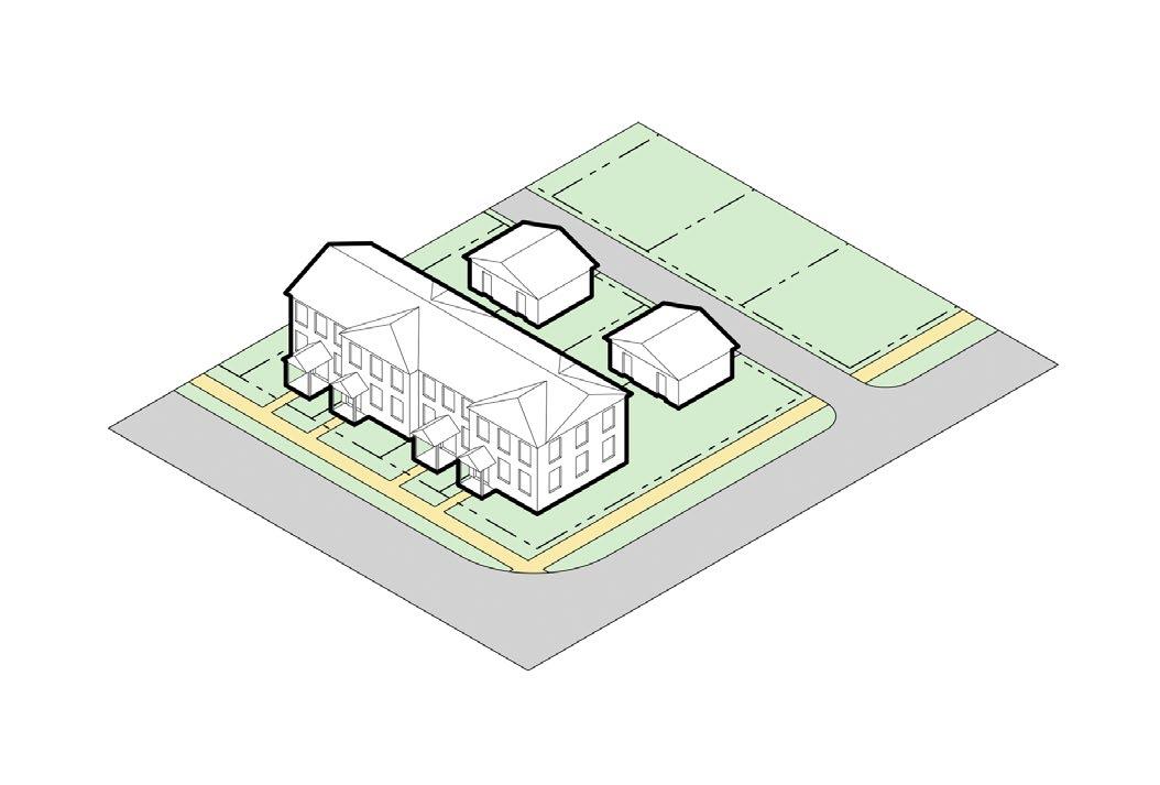
Figure 1150-02: Graphic of a four-unit townhouse structure. In this example, the townhouses are each located on their own lot, representing a fee-simple approach, where no land is communally owned by a homeowners association (HOA).
(v) Ownership Model of Townhouse Residential Developments. Townhouses have four main ownership models, as described and illustrated below:
(1) Rentals. In this ownership model, all of the housing units, all common area, and all parking is located on one lot and has one owner. Typically, this ownership model is employed where the units of the townhouse complex are renter-occupied. In this case, any code violations can be directed to the landlord.
(2) Condominium. In this ownership model, the housing units themselves are condominiums and are individually owned. However, all of the land, including the land under the condominiums, is communally owned by a condominium association. The owners of the individual condominiums are members of the condominium association and make decisions according to their bylaws. In this case, any code violations for building maintenance of individual units can be directed to the unit’s owner, and any code violations for landscaping or other land-related regulations can be directed to the condominium association.
City of Garfield Heights, Ohio, Planning and Zoning Code
>Title Three | Land Use Standards
>>Chapter 1150: Use-Specific Regulations for Principal Uses
(3) Landominium. In this ownership model, the housing units themselves and the land under the housing units and sometimes additional land adjacent to the units are individually owned. Other land, including a common green space, buffer area, utility areas, etc., are owned by a condominium association. The owners of the individual housing units are members of the condominium association and make decisions according to their bylaws. In this case, any code violations for building maintenance of individual units or the land owned by the owners of such individual units can be directed to the unit’s owner, and any code violations for landscaping or other land-related regulations on communal land can be directed to the condominium association.
(4) Fee-Simple. In this ownership model, there is no communally owned land. Each housing unit is individually owned, and each housing unit owner also owns the land under the unit and surrounding the unit. One landowner’s property extends all the way to the neighbor’s property. Generally, these types of townhouse lots extend from the public street in the front to the public alley in the rear. Any code violation can be directed to the owner of land on which the violation has occurred.
(vi) Plan Required. No townhouse shall be permitted except where an application for such use contains a to-scale plan illustrating (1) the location of each townhouse, (2) interior circulation, if applicable, (3) access to public rights-ofway, (4) screening, (5) solid waste storage and removal areas, and (6) emergency fire-response fire lanes and fire hydrant locations.
(vii) Emergency Response for Townhouses. No townhouse shall be permitted except where each townhouse unit within the complex is adequately accessible to public emergency response, including fire response, medical response, and law enforcement response; any application for a zoning permit for a townhouse complex shall be subject to review and approval by the City.
(C) Accessory Use Standards. For details on accessory uses associated with this land use, such as home occupations, please refer to Chapter 1151 “Accessory Use and Structure Regulations.”
(D) Cottage Court Standards. This use term is not the same as Cottage Court Residential uses. For details on the development of cottage courts, please refer to §1150.08 “Cottage Courts Residential”.
(A) Definition. The definition of this land use can be found in Title Nine "Glossary of Terms” of this Planning and Zoning Code.
(B) Use-Specific Standards. This Planning and Zoning Code does not contain standards specific to this land use; however, please note that this Planning and Zoning Code’s district-specific standards, sign standards, and generally applicable standards shall apply to this land use, and please note that the Building Code standards shall apply to this land use.
City of Garfield Heights, Ohio, Planning and Zoning Code
>Title Three | Land Use Standards
>>Chapter 1150: Use-Specific Regulations for Principal Uses
(C) Accessory Use Standards. For details on accessory uses associated with this land use, such as home occupations, please refer to Chapter 1151 “Accessory Use and Structure Regulations.”
(A) Definition. The definition of this land use can be found in Title Nine "Glossary of Terms” of this Planning and Zoning Code.
(B) The outdoor storage of recreational vehicles (RVs) shall be governed by §1155.18 “Parking of Recreational Vehicles”
(C) Use-Specific Standards
(i) No painting of vehicles shall occur in an outdoor setting.
(ii) No car wash or car cleaning establishment shall operate within 500 feet of a residential use during the hours of 10:00pm to 8:00am.
(iii) No storage of volatile, combustible, or hazardous fluid shall occur within 100 feet of a residential use.
(iv) The storage of inoperable vehicles shall be limited to five vehicles per indoor repair bay. For the purposes of this provision, an inoperable vehicle is any vehicle that cannot normally start and drive or lacks fuel, one or more inflated tires, one or more operable lights, or one or more windows or mirrors
§1150.34 VEHICLE STORAGE
(A) Definition. The definition of this land use can be found in Title Nine "Glossary of Terms” of this Planning and Zoning Code.
(B) The outdoor storage of recreational vehicles (RVs) shall be governed by §1155.18 “Parking of Recreational Vehicles”.
(C) Use-Specific Standards.
(i) Where more than 10 fleet vehicles, commercial vehicles, school buses, recreational vehicles, or boats are stored and where the storage area is within 200 feet of an adjacent lot, the vehicle storage area shall be screened with a eight-foot-high opaque fence or hedgerow on all sides, except where a building serves as screening and except where there is an entrance or exit to the storage area.
(ii) No such use shall be issued a Zoning Permit by the Building Commissioner or be permitted to commence except following review and written authorization of the City Council. In reviewing a proposed use, the Planning Commission, the Zoning Board of Appeals, and the City Council shall consider the use’s vicinity to existing and planned schools, daycare facilities, playgrounds, libraries, parks, recreational fields, and places of worship; the use’s vicinity to existing or planned Adult-Oriented Uses, Bail Bond Lending Uses, Pawn Shops, Marijuana-, Vape-, or Smoke-Oriented Uses, Weapons-Oriented Uses, and Vehicle Storage
City of Garfield Heights, Ohio, Planning and Zoning Code
>Title Three | Land Use Standards
>>Chapter 1150: Use-Specific Regulations for Principal Uses
Uses; the use’s vicinity to governmental offices; and the use’s vicinity to existing or planned residential and institutional properties.
§1150.35 WEAPONS-ORIENTED USES
(A) Definition. The definition of this land use can be found in Title Nine "Glossary of Terms” of this Planning and Zoning Code.
(B) Use-Specific Standards
(i) No Weapons-Oriented use shall be conducted except where distanced at least 500 feet from any residential use.
(ii) No such use shall be issued a Zoning Permit by the Building Commissioner or be permitted to commence except following review and written authorization of the City Council. In reviewing a proposed use, the Planning Commission, the Zoning Board of Appeals, and the City Council shall consider the use’s vicinity to existing and planned schools, daycare facilities, playgrounds, libraries, parks, recreational fields, and places of worship; the use’s vicinity to existing or planned Adult-Oriented Uses, Bail Bond Lending Uses, Pawn Shops, Marijuana-, Vape-, or Smoke-Oriented Uses, Weapons-Oriented Uses, and Vehicle Storage Uses; the use’s vicinity to governmental offices; and the use’s vicinity to existing or planned residential and institutional properties.
§1151.01 DEFINITION. The definition of accessory uses and accessory structures can be found in Title Nine "Glossary of Terms” of this Planning and Zoning Code.
§1151.02 PERMISSIBILITY OF ACCESSORY USES AND STRUCTURES. Accessory uses and accessory structures are allowed in any district unless otherwise specified by this Chapter, this Planning and Zoning Code, or other City provision.
§1151.03 PERMIT REQUIRED FOR ACCESSORY USES. A zoning permit is not required for most accessory uses except where specified by this Planning and Zoning Code, such as for Day Care Homes
§1151.04 PERMIT REQUIRED FOR ACCESSORY STRUCTURES. A zoning permit is required for any accessory structure that occupies more than 10 square feet and less than 200 square feet. Fences, regulated in Chapter 1157, shall require a fence permit.
§1151.05 SIGNS. Outdoor advertising or signs may be considered accessory uses and structures, but such uses and structures are not regulated by this Chapter; signs are regulated in Title Five "Sign Regulations”.
§1151.06 LOCATION OF ACCESSORY STRUCTURES
(A) An accessory use and any accessory structure in or on which it is conducted must be located on the same lot as or an abutting lot to the principal use with which it is
City of Garfield Heights, Ohio, Planning and Zoning Code
>Title Three | Land Use Standards
>>Chapter 1151: Accessory Use and Structure Regulations
associated; this provision may be waived through a variance granted by the Board of Zoning of Appeals.
(B) Arrangement. An accessory dwelling unit may be arranged as a detached structure, such as a garage conversion or a carriage house; or as a structure attached to or a part of the principal dwelling, such as a basement unit or an attic unit.
(A) With the exception of certain accessory structures detailed in this Section, all portions of an accessory structure shall be set back from any lot line by at least three horizontal feet.
(B)
(i) Ground-level uses and structures, such as asphalt or concrete paving, pavers, mulching, sod, artificial turf, gardens and landscaping, and wood or faux-wood decking entirely within 8 inches of ground level, shall not be subject to the setback requirements that are generally applicable to accessory structures found in this subsection Raised garden beds shall constitute ground-level structures if the tops of their sidewalls are within 12 inches of ground level.
(ii) Within districts with minimum front setbacks for principal structures of 10 feet or less: front porches, balconies, elevated terraces, and stoops, where such accessory structures are not enclosed by windows and are open to the outdoors except for railings, waist-level walls, or insect screens shall not be subject to the front setback requirement that are generally applicable to accessory structures found in this subsection; instead, such accessory structures may extend up to six feet from the front of the principal structure. Such accessory structures shall not be permitted to extend beyond the front lot line into the public right-of-way unless granted an encroachment permit by the City.
(iii) Fences shall be considered accessory structures but shall not be subject to the setback requirements that are generally applicable to accessory structures found in this subsection; fences are regulated by Chapter 1157 “Fence Standards”
(iv) Signs shall not be subject to the setback requirements that are generally applicable to accessory structures found in this subsection; signs are regulated by Title Five "Sign Regulations”.
(v) With the exception of wind turbines mounted to the roof of the principal structure, no wind turbine shall be erected except where its base is set back from all lot lines by a distance equal to its height, where the height of a wind turbine shall be measured from the ground elevation to the highest reach of any of its blades.
(vi) Add-on accessibility ramps and add-on accessibility elevators designed to allow access to the premises for persons with disabilities or with ambulatory challenges shall not be required to conform to the setback requirements that are generally applicable to accessory structures found in this subsection;
City of Garfield Heights, Ohio, Planning and Zoning Code
>Title Three | Land Use Standards
>>Chapter 1151: Accessory Use and Structure Regulations
instead, such accessibility ramps and accessibility elevators shall be permitted to be installed up to the edge of any lot line. This provision shall not apply to permanent accessibility ramps, such as those constructed with concrete as part of a new commercial structure, and shall not apply to permanent, integrated elevators, such as those installed in permanent elevator shafts in a new commercial or multi-unit residential building.
§1151.08 HEIGHT MAXIMUMS FOR ACCESSORY STRUCTURES. No accessory structure shall be erected except where such accessory structure satisfies all of the following conditions:
(A) On any portion of the lot where a principal structure would be permitted to be built, such as any area of the lot far enough from a lot line to meet the required minimum setback requirements for principal structures, no portion of an accessory structure may exceed the maximum height allowed for a principal structure in the district in which it is located; such height allowances can be found within the applicable district section of Title Two "Zoning District Standards” Please note, however, that this Code allows for exceptions to height allowances for specified features, such as steeples, chimneys, wind turbines, and the like; for such exceptions, please refer to §1136.02 “Exceptions to Height Maximums”.
(B) On any portion of the lot where a principal structure would not be permitted to be built, such as any area of the lot closer to a lot line than required by the minimum setback requirements for principal structures, no portion of an accessory structure may exceed 18 feet in height; this provision shall not apply to signs, which are regulated by Title Five "Sign Regulations”. Please note, however, that this Code allows for exceptions to height allowances for specified features, such as steeples, chimneys, wind turbines, and the like; for such exceptions, please refer to §1136.02 “Exceptions to Height Maximums”.
(C) No accessory structure, including an accessory wind energy system, shall impair the safe operation of aircraft, as determined by the Federal Aviation Administration.
§1151.09 SWIMMING POOL AND HOT TUB FENCES. Swimming pools and hot tubs shall be required to install a fence to prevent the accidental entrance and drowning of children; such regulations can be found in Chapter 1157 “Fence Standards”.
§1151.10 SPECIFIC ACCESSORY USE AND ACCESSORY STRUCTURE STANDARDS. Specific accessory use and accessory structure standards are included for accessory dwelling units, home occupations, cottage industries, and family day-care homes. These standards can be found in the following subsections.
§1151.11 STANDARDS APPLICABLE TO ACCESSORY DWELLING UNITS
(A) Definition. An accessory dwelling unit is a dwelling unit that facilitates a dwelling use secondary to a principal one-unit dwelling. Accessory dwelling units are sometimes referred to as granny flats, in-law suites, and carriage houses. If a lot contains a principal dwelling and an accessory dwelling, and if such accessory dwelling is detached from the principal dwelling, the accessory dwelling shall be the dwelling with the greater setback from the front lot line.
City of Garfield Heights, Ohio, Planning and Zoning Code
>Title Three | Land Use Standards
>>Chapter 1151: Accessory Use and Structure Regulations
(B) Eligibility. No accessory dwelling unit may be erected except where all of the following conditions are satisfied:
(i) The accessory dwelling unit is located within a district that permits one-unit dwellings via administrative review;
(ii) The accessory dwelling unit is located on a lot that contains a one-unit dwelling;
(iii) The accessory dwelling unit is located on a lot that conforms to the minimum lot area, minimum lot width, and minimum lot depth standards of the district in which it is located.
(C) Creation. An accessory dwelling unit may be created through new construction, the conversion of an existing structure, as an addition to an existing structure, or as a conversion of a qualifying existing one-unit dwelling during the construction of a new principal dwelling unit on the site.
(D) Arrangement. An accessory dwelling unit may be arranged as a detached structure, such as a garage conversion, or as attached to the principal one-unit dwelling, such as a basement unit or an attic unit.
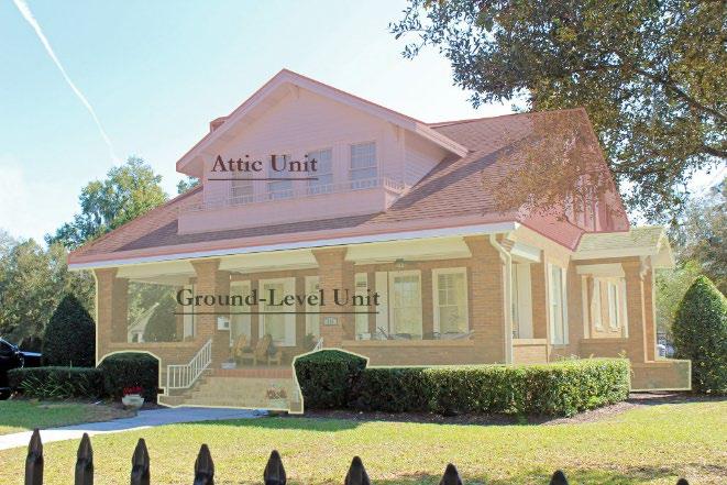
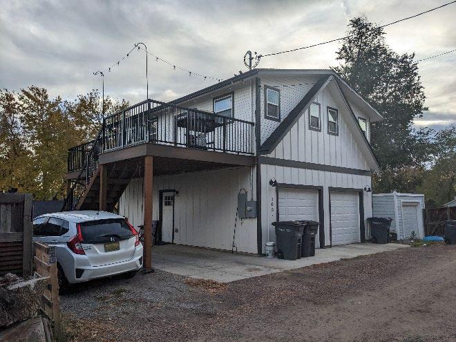
City of Garfield Heights, Ohio, Planning and Zoning Code
>Title Three | Land Use Standards
>>Chapter 1151: Accessory Use and Structure Regulations
1151-02:
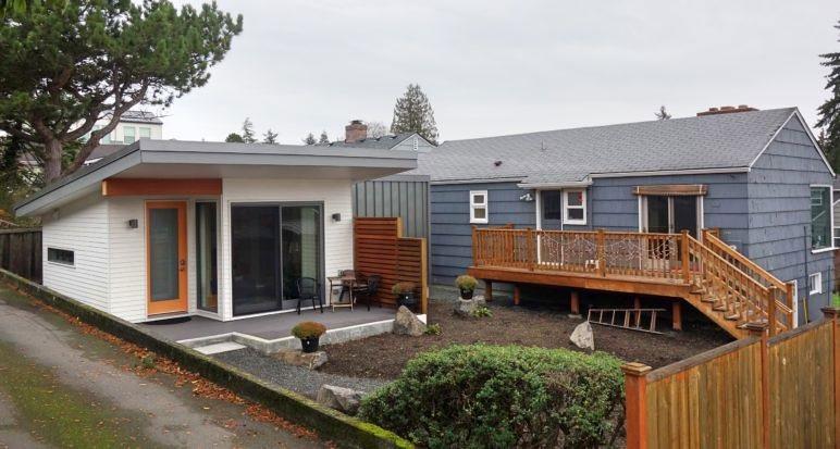
(E) Amenities Required. An accessory dwelling unit shall, at a minimum, contain all of the following amenities:
(i) A sleeping area or a bedroom area as defined by the applicable building code and provides light, air, ingress, and egress as required by the applicable building code;
(ii) A toilet and bathing facility;
(iii) A “junior kitchen” area that includes a kitchen sink and allows for the installation of plug-in kitchen appliances, such as a microwave, a single-burner, a toaster oven, and similar devices, meeting plumbing, electrical, and fire prevention requirements of the applicable building code; and
(iv) Utility separation from the principal one-unit dwelling where required by the applicable building code.
(F) Quantity. No lot may contain more than one accessory dwelling unit.
(G) Occupancy and Use
(i) An accessory dwelling unit must conform to all building code and health code standards applicable to all dwellings.
(ii) Occupancy of an accessory dwelling unit shall be limited to two adults per bedroom, as bedroom is defined by the building code; children shall not be counted for the purposes of this provision.
(H) Size and Height
(i) No accessory dwelling unit may exceed 1,200 square feet of gross floor area.
(ii) Accessory dwelling units shall conform to the height maximums generally applicable to accessory structures.
City of Garfield Heights, Ohio, Planning and Zoning Code
>Title Three | Land Use Standards
>>Chapter 1151: Accessory Use and Structure Regulations
(I) Location. If an accessory dwelling unit is detached from the principal structure, no portion of such accessory dwelling unit shall be closer to the front lot line than the forward-most portion of the principal structure.
(J) Screening. If an accessory dwelling unit is detached from the principal structure and is within six feet of a rear lot line or side lot line, such lot lines shall be screened with (1) six-foot-high opaque fencing or (2) a six-foot-high evergreen hedgerow; such fencing or hedgerow shall be required only along the portion of the lot lines within six feet of the accessory dwelling unit. Such screening shall not be required where the lot line abuts a public alleyway. Such screening shall not be required where the side of the accessory dwelling unit within six feet of the lot line does not include any windows or other transparent material; glass blocks and frosted glass shall be treated as non-transparent materials.
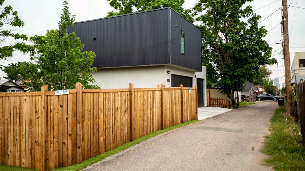
(K) Parking. An accessory dwelling unit shall not require off-street parking.
§1151.12 STANDARDS APPLICABLE
(A) Definition. The definition of Home Occupation may be found in Title Nine "Glossary of Terms” of this Planning and Zoning Code.
(B) Permitting A home occupation shall be permitted by right in the Residential 1 District, the Residential 2 District, the Neighborhood Mixed-Use District, and the Turney Road Core Mixed-Use District. No application or zoning permit shall be required to conduct a home occupation.
(C) Home Occupation Standards. All home occupations shall conform to all of the following standards:
(i) The use shall be clearly incidental and subordinate to the principal residential use.
City of Garfield Heights, Ohio, Planning and Zoning Code
>Title Three | Land Use Standards
>>Chapter 1151: Accessory Use and Structure Regulations
(ii) The home occupation shall be owned, operated, and conducted by a person for whom the dwelling is the person’s principal residence; however, up to two non-resident persons may be employed in the home occupation. More than two but not more than four non-resident persons may be employed in the home occupation with approval of the Planning Commission after consideration of written application from the business owner detailing factors including but not limited to parking demand and availability, days and hours of employment, location and amount of work space, nature of work, noise generation, and proximity to other dwellings. Persons employed off-site by the home occupation and who do not regularly enter onto the property as part of their employment are not considered employees for purposes of these regulations.
(iii) The home occupation shall be conducted wholly within the dwelling, except that activities associated with the home occupation may be conducted in the rear yard or in an existing accessory building if meeting the following minimum standards:
(iv) The floor area of any accessory building(s) used for the home occupation shall not exceed 500 square feet. Enclosed parking required for the dwelling use shall be maintained in addition to any floor area used for the home occupation.
(v) Outdoor storage of materials, products, waste, equipment, vehicles, trailers, or other items associated with the home occupation may be permitted only in an area of the rear yard not greater than 400 square feet and screened by solid fencing on all sides.
(vi) Activities associated with the home occupation shall only be conducted in the rear yard or in an accessory building between the hours of 7 a.m. and 7 p.m.
(vii) The floor area used for the home occupation (or in total for all home occupations if more than one home occupation is conducted in a dwelling unit) shall not exceed 50 percent of the floor area of the dwelling unit.
(viii) Signs shall comply with the regulations applicable to the zoning district.
(ix) Site or building features of a nonresidential nature shall not be permitted in association with the home occupation; however, the home occupation may, where prudent or required, employ a commercial refuse service or a backflow prevention device on its water supply line.
(x) No heavy truck associated with the home occupation shall be stored at the residence, except within a fully enclosed garage.
(xi) On-site sales or repair of automobiles shall not be conducted as a primary activity or regularly scheduled activity of the home occupation.
(xii) On-site sales of merchandise shall not be conducted as a primary activity or regularly scheduled activity of the home occupation.
(xiii) The home occupation shall not generate traffic in greater volume than normal for a dwelling. Regular shipping or delivery shall only occur in single rear axle straight trucks or smaller vehicles normally serving residential areas.
(xiv) Customers. No more than two clients or customers shall be permitted to visit the dwelling at one time. No home occupation shall allow any in-person
City of Garfield Heights, Ohio, Planning and Zoning Code
>Title Three | Land Use Standards
>>Chapter 1151: Accessory Use and Structure Regulations
§1151.13
§1151.14
customer to occupy a street-parking spot. A home occupation may not serve in-person customers between the hours of 8:00 PM and 7:00 AM.
(xv) No equipment or process shall be permitted which creates noise, vibration, glare, fumes, odors or electrical interference detectable to the normal senses off the lot or, if in a multiple dwelling, outside of the dwelling unit.
(xvi) The home occupation shall not create any increased service demand upon City services normally provided to the dwelling, including but not limited to volume or type of waste collection.
(xvii) Outdoor Storage of Home Occupation-Related Materials. No home occupation shall result in the storage of materials outdoors and visible from the right-ofway, including lawn care equipment associated with a home occupation, vehicles or tires associated with a home occupation, and fuels or fluids associated with a home occupation.
(xviii) Dog-Related Home Occupations. No home occupation shall comprise the raising and sale of more than one litter of puppies at any time per lot; for the purposes of this provision, a litter of puppies shall be defined as any grouping of dogs born of the same pregnancy and under the age of 6 months. On any lot of less than 3 acres or on any lot containing a more than one dwelling unit, no home occupation shall comprise the boarding of more than 4 dogs; on any other lot, no home occupation shall comprise the boarding of more than 6 dogs; the number of dogs permitted shall be reduced by one for each dog that resides on the premises; the boarding of more dogs shall constitute a principal Animal Boarding or Shelter use.
(A) Definition. The definition of Day Care Home may be found in Title Nine "Glossary of Terms” of this Planning and Zoning Code.
(B) Permitting. A Day Care Home “Type A” is allowed as an accessory to any lawful residential use but shall be permitted only through a conditional use approval granted by the Zoning Board of Appeals. A Day Care Home “Type B” is allowed as an accessory use to any lawful residential use and shall be permitted through an administrative review.
(C) Use-Specific Standards. No day-care home services use shall be conducted except where all of the following conditions are satisfied:
(i) The play area is fenced in, so as to provide a safe and secure environment for the children; and
(ii) The drop-off/pick-up is located so as not to impede traffic safety.
(A) Definition. The definition of Drive-Thru Services may be found in Title Nine "Glossary of Terms” of this Planning and Zoning Code.
City of Garfield Heights, Ohio, Planning and Zoning Code
>Title Three | Land Use Standards
>>Chapter 1151: Accessory Use and Structure Regulations
(B) Use-Specific Standards
(i) No Drive-Thru Services use shall cause the blocking of a fire lane, and no vehicle stacking area of a Drive-Thru Services use shall cause the blocking of handicapped accessible parking spaces or use areas.
(ii) No Drive-Thru Services use shall amplify sound to a volume audible by the users of adjacent lots.
(A) Definition. The definition of Electric Vehicle Charging may be found in Title Nine "Glossary of Terms” of this Planning and Zoning Code.
(B) Use-Specific Standards
(i) Electric Vehicle Charging shall be considered an accessory use of any vehicle parking space.
(ii) No electric vehicle charger may be located within three feet of a lot line.
(iii) No electric transformer box associated with nine or more electric vehicle charging stations may be situated on a lot except when screened with a fully opaque fence or wall.
(A) Definition. The definition of Home Animal Husbandry may be found in Title Nine "Glossary of Terms” of this Planning and Zoning Code.
(B) Use-Specific Standards
(i) No Home Animal Husbandry use shall be permitted in any multi-unit residential use (i.e., two-unit dwelling, 3-8-unit dwelling, 9-plus-unit dwelling, townhouse dwelling, cottage court dwelling, or mobile home park).
(ii) No Home Animal Husbandry may consist of the raising of any non-pet species except for chickens. Common pet species, such as dogs and cats, shall not be considered Home Animal Husbandry.
(iii) No Home Animal Husbandry accessory use may store or dispose of animal wastes within 15 feet of a property line.
(iv) No Home Animal Husbandry accessory use shall consist of the slaughtering of animals.
(v) Dog breeding on a lot containing a residential use shall not be permitted
(vi) Living areas or grazing areas shall be appropriately defined and protected; for example, an enclosure for cattle, horses, or bison shall utilize adequately fortified fencing to prevent break-outs.
City of Garfield Heights, Ohio, Planning and Zoning Code
>Title Three | Land Use Standards
>>Chapter 1151: Accessory Use and Structure Regulations
(vii) Any electric fencing shall be clearly marked with signs as posing a shock danger using both words and visuals. No electrified fence shall be installed within three feet of a lot line.
§1151.17 STANDARDS FOR ACCESSORY SOLAR ENERGY SYSTEMS OR WIND ENERGY SYSTEMS. Solar energy systems and wind energy systems shall be governed by Chapter 1153 “Renewable Energy Systems Regulations”
§1152.01 Definition. The definition of Temporary Use may be found in Title Nine "Glossary of Terms” of this Planning and Zoning Code.
§1152.02 Permitting. No temporary use shall be permitted except with a valid Temporary Use permit, issued by the Building Commissioner. For all proposals, the Building Commissioner will require review by the Law Director, Economic Development Director, and Fire Chief to ensure that adequate fire egress or other safety concerns are addressed. Each temporary use permit shall indicate the date at which the use is proposed to begin and the date of expiration of the permit; a Temporary Use permit may be extended by the Building Commissioner; where the temporary use is conducted after the date of expiration of the Temporary Use permit, the use shall be considered to be conducted in violation of this Planning and Zoning Code.
§1153.01 SOLAR ENERGY SYSTEMS, DEFINITION. A solar energy system, for the purposes of this Planning and Zoning Code, shall be considered any photovoltaic panel or array of such panels, intended to produce electricity; this term shall also include solar panels intended to heat water, where such water feeds an electricity generation system or where such water feeds a hot water system of a building. Solar energy system, for the purposes of this Planning and Zoning Code, shall not include passive solar heating, as may be found in greenhouses; shall not include solar panels affixed to vehicles such as RVs; and shall not include solar panels smaller than one square foot, such as those that may be found in outdoor rechargeable decorative lighting or hunter’s trail cameras.
§1153.02
(A) Defining a Solar Energy System as a Principal Use. For the purposes of this Planning and Zoning Code, solar energy systems shall be considered principal uses of a lot where the projected annual electricity generation of the solar energy system exceeds 150% of the projected annual electricity demand of all uses of the lot or of the total of the lot and an adjacent lot where the electricity generated by the solar energy system supplies electricity to an adjacent lot. For example, where a lot contains one use, a house, and such house is projected to demand 12,000 kWh of electricity per year, a solar energy system would be considered a principal use only where it is expected to generate in excess of 18,000 kWh per year; if it is not expected to generate in excess of 18,000 kWh per year, it shall be considered an accessory use and shall be governed by the following sections of this chapter
City of Garfield Heights, Ohio, Planning and Zoning Code
>Title Three | Land Use Standards
>>Chapter 1152: Temporary Use Regulations
§1153.03
(B) Permitting a Solar Energy System as a Principal Use of a Lot. A solar energy system that is considered a principal use of a lot shall be permitted to be erected or conducted in any district where expressly granted permission through a conditional use review process.
(A) Defining a Solar Energy System as an Accessory Use. Where a solar energy system is not projected to generate in excess of 150% of the projected annual energy demand of the principal use of the lot or of the total of the lot and an adjacent lot where the electricity generated by the solar energy system supplies electricity to an adjacent lot, it shall be considered an accessory use to the principal use of the lot or to principal use of the adjacent lot.
(B) Accessory solar energy systems, including their mounting and wiring components, shall be permitted in all districts and shall be controlled by the standards described in the sections below of this Chapter.
§1153.04
a solar energy system is an accessory use to a one-unit, two-unit, three-unit, or four-unit residential use, it shall conform to all of the following standards:
(A) Roof Flush-Mounting Required. A solar energy system that is accessory to a one-tofour-unit residential use shall be flush-mounted to the roof of the principal structure. For the purposes of this Planning and Zoning Code, flush-mounted shall mean that the solar panels are affixed parallel to the contour of the roof’s surface and shall not extend from the roof’s surface a distance greater than that required by the mounting brackets, typically less than 12 inches.
(B) Mounting to Awnings and Other Roof-Like Surfaces. A solar energy system that is accessory to a one-to-four-unit residential use may be flush-mounted to the following specified roof-like structures only with permission granted through a conditional use review process: permanent over-the-door awnings, permanent over-the-window awnings, permanent roofs of porches, permanent roofs of permitted accessory dwelling units, and permanent roofs of attached or detached garages. No solar energy system shall not be mounted on temporary roofs, such as tarps or plastic roofs, on sheds, or on carports, except where the carports are permanent structures with concrete footings.
(C) Ground-Mounting Prohibited. No solar energy system that is accessory to a one-tofour-unit residential use may be ground-mounted in any yard area. For the purposes of this Planning and Zoning Code, ground-mounted shall mean that the solar panels are placed on or affixed to the ground or are placed or affixed to a frame or armature on to the ground’s surface.
§1153.05
OR MIXED USES. Where a solar energy system is an accessory use to a large residential use (i.e., residential uses with five or more units per building), to any non-heavy-industrial commercial use, or to a structure with a mix of commercial and residential uses (i.e., a mixed-use structure), it shall conform to all of the following standards:
City of Garfield Heights, Ohio, Planning and Zoning Code
>Title Three | Land Use Standards
>>Chapter 1153: Renewable Energy Systems Regulations
(A) Requirements for Roof-Mounting. Roof-mounted solar energy systems that are accessory to a large residential use (i.e., residential uses with five or more units per building), to any non-heavy-industrial commercial use, or to a structure with a mix of commercial and residential uses (i.e., a mixed-use structure) shall be permitted to be mounted at an angle that differs from the slope of the roof and shall be permitted to exceed the maximum structure height within the applicable district; however, no portion of a solar panel in the system shall extend beyond five vertical feet from the roof’s surface at the portion of the roof below the solar panel
(B) Mounting to Awnings and Other Roof-Like Surfaces. A solar energy system that is that accessory to a large residential use (i.e., residential uses with five or more units per building), to any non-heavy-industrial commercial use, or to a structure with a mix of commercial and residential uses (i.e., a mixed-use structure) may be flush-mounted to the following specified roof-like structures: permanent over-the-door awnings, permanent over-the-window awnings, permanent roofs of porches, permanent roofs of permitted accessory dwelling units, and permanent roofs of attached or detached garages. No solar energy system shall not be mounted on temporary roofs, such as tarps or plastic roofs, on sheds, or on carports, except where the carports are permanent structures with concrete footings.
(C) Ground-Mounting. No solar energy system that is accessory to a large residential use (i.e., residential uses with five or more units per building), to any non-heavy-industrial commercial use, or to a structure with a mix of commercial and residential uses (i.e., a mixed-use structure) may be ground-mounted in any yard area except with permission granted through a conditional use review process For the purposes of this Planning and Zoning Code, ground-mounted shall mean that the solar panels are placed on or affixed to the ground or are placed or affixed to a frame or armature on to the ground’s surface.
§1153.06 SOLAR ENERGY SYSTEMS AS ACCESSORY USES TO HEAVY INDUSTRIAL USES. Where a solar energy system is an accessory use to a heavy industrial use, it shall conform to all of the following standards:
(A) Requirements for Roof-Mounting. Roof-mounted solar energy systems that are accessory to a heavy industrial use shall be permitted to be mounted at an angle that differs from the slope of the roof; however, no portion of a solar panel in the system shall extend greater than five vertical feet from the roof’s surface.
(B) Mounting to Awnings and Other Roof-Like Surfaces. A solar energy system that is accessory to a heavy industrial use may be flush-mounted to the following specified roof-like structures: permanent over-the-door awnings, permanent over-the-window awnings, permanent roofs of porches, and permanent roofs of attached or detached garages. No solar energy system shall not be mounted on temporary roofs, such as tarps or plastic roofs, on sheds, or on carports, except where the carports are permanent structures with concrete footings.
(C) Ground-Mounting in Front Yard Area. No solar energy system that is accessory to a heavy industrial use may be ground-mounted in any front yard area except with permission granted through a conditional use review process; ground-mounting in the side and rear yard area shall be permitted without conditional use review where such
City of Garfield Heights, Ohio, Planning and Zoning Code
>Title Three | Land Use Standards 83
>>Chapter 1153: Renewable Energy Systems Regulations
panels maintain a five-foot setback from the lot lines and where such panels do not exceed eight feet in height. For the purposes of this Planning and Zoning Code, groundmounted shall mean that the solar panels are placed on or affixed to the ground or are placed or affixed to a frame or armature on to the ground’s surface.
§1153.07 REQUIREMENTS APPLICABLE TO ALL SOLAR ENERGY SYSTEMS. The following requirements apply to all solar energy systems
(A) Battery Storage Systems. Large energy storage systems, such as industrial-scale batteries, intended to capture and later release the energy produced by solar energy systems, shall be permitted only when granted permission through a conditional use review process. This requirement does not apply to small-scale battery systems, defined as battery systems conventionally found in a home, similar to a Tesla-brand Powerwall, with storage capacities of less than 150 kWh.
(B) Transmission Underground. Power transmission lines from a ground-mounted accessory solar energy system shall be located underground.
(C) No signage or graphic content may be displayed on an accessory solar energy system except the manufacturer’s badge, safety information, and equipment specification information. The total area of such display shall not exceed the size and information required by the National Electrical Code. This display shall not be interpreted as a sign and shall not be subject to this Code’s Title Five "Sign Regulations”
(D) Roof-mounted panels may not be mounted as to reach beyond the edge of the roofline.
(E) Abandonment and Removal. If a solar energy system is nonfunctional or inoperative for a continuous period of one year, the system shall be deemed abandoned and shall constitute a public nuisance. The owner shall remove the abandoned system and all appurtenances.
(F) Installation shall conform to applicable building and safety codes and manufacturer’s instructions.
§1153.08 REGULATIONS FOR WIND ENERGY SYSTEMS
No wind energy system, defined hereafter, shall be erected or put to use in the City of Garfield Heights, except where such system qualifies as a nonconforming structure per Title Eight "Nonconformities” For the purpose of this section, a wind energy system shall be defined as an outdoor structure with spinning, rotating, or oscillating components, driven by the atmosphere’s air currents, designed to generate electricity. Decorative, farm-style windmills that are not connected to an electric generator or a water pump shall not be considered a wind energy system for the purposes of this code.
City of Garfield Heights, Ohio, Planning and Zoning Code
>Title Three | Land Use Standards
>>Chapter 1153: Renewable Energy Systems Regulations
§1154.01
Council hereby intends this chapter to be comprehensive and superseding commercial wireless telecommunications legislation. Wireless telecommunications facilities are permitted as conditional uses in a variety of zoning districts contingent upon a number of requirements being met, including but not limited to meeting all provisions and requirements of these Codified Ordinances. These criteria are in place in an attempt to minimize adverse health, safety, public welfare or visual impacts through buffering, siting, design, and construction and reduction of the need for new towers.
§1154.02 CRITERIA
Wireless telecommunications facilities may be permitted as a conditional use in the City, after application for, and granting of, a conditional use permit, by the Building Commissioner, and approval of said conditional use permit by the Planning Commission and Council. Grant of a permit is dependent upon the applicant meeting all of the general use regulations of this chapter and the particular zoning regulations required in this chapter depending on which zoning district the proposed wireless telecommunications facility is to be located. The following sections describe the steps necessary for the application to be considered for review:
(A) The applicant shall demonstrate that the telecommunications tower must be located where it is proposed in order to service the applicant's service area. There shall be an explanation of why a tower and this proposed site is technically necessary.
(B) Any applicant requesting permission to install a new tower shall provide evidence of written contracts with all wireless service providers who supply service within a quarter mile of the proposed facility. The applicant shall inquire about potential collocation opportunities at all technically feasible locations. The contacted providers shall be requested to respond in writing to the inquiry within thirty days. The applicant's letter(s) as well as response(s) shall be presented to the Building Commissioner, Planning Commission, and Council as a means of demonstrating the need for a new tower.
(C) The applicant shall present a landscaping plan that indicates how the wireless telecommunications facility will be screened from adjoining uses.
(D) Where the telecommunications facility is located on a property with another principal use, the applicant shall present documentation that the owner of the property has granted an easement or entered into a lease for the proposed facility and that vehicular access is provided to the facility.
§1154.03
GENERAL
The following general use restrictions apply to all persons, firms, partnerships, corporations, limited liability companies, trusts, joint stock companies, unincorporated associations, governmental entities, banking institutions, and any other organization wishing to construct, operate, maintain, reconstruct, and/or rebuild a wireless telecommunications facility, and are subject to inspection by the Building Commissioner regardless of whether they are a conditional or permitted use, and regardless of the zoning district in which they are to be located. These general standards are to be supplemented with specific regulations for nonresidential and residential district regulations as set forth later in this Chapter.
(A) A conditional use permit must be issued by the Building Commissioner and approved by the Planning Commission and Council for construction of new towers in nonindustrial districts. However, construction of new towers in industrial districts, collocation of antennas on a single existing tower, and antennas attached to existing structures or buildings that are located in industrial districts, or replacement towers to be constructed at the site of a current tower, are permitted uses and will not be subject to the conditional use permitting process.
(B) Any decision to deny a request to place, construct, or modify a wireless telecommunications antenna and/or tower shall be in writing and supported by evidence contained in a written record of the proceedings of the Planning Commission, or in a written record of the investigation by the Building Commissioner.
(C) All providers utilizing towers shall notify the Building Commissioner of any tower facility located in the Municipality whose use will be discontinued and the date this use will cease. If at any time the use of the facility is discontinued for 180 days, the Mayor may declare the facility abandoned. (This excludes any dormancy period between construction and the initial use of the facility). The facility's owner/operator will receive written notice from the Building Commissioner of instructions to reactivate the facility's use within 180 days, or to dismantle and remove the facility. If reactivation or dismantling does not occur, the Municipality will remove or contract to have removed the facility and assess the owner/operator the costs.
(D) When a proposed wireless telecommunications facility is to include a new tower, a plot plan at scale of not less than one inch equal to 100 feet shall be submitted. This plot plan shall indicate all building's uses within 500 feet of the proposed facility. Aerial photos and/or renderings shall augment the plot plan.
(E) The location of all towers and equipment shelters shall comply with all natural resource protection standards established in the Planning and Zoning Code, including those for floodplain, wetlands, and steep slopes.
(F) Security fencing ten feet in height, topped with barbed wire shall completely surround all towers, equipment shelters and any guy wires, either completely or individually as determined by the Planning Commission.
(G) The following buffer planting may be required around the perimeter of the security fence as deemed appropriate by the Building Commissioner:
(i) An evergreen screen shall be planted that consists of either a hedge, planted three feet on center maximum, or a row of evergreen trees planted five feet on center maximum.
(ii) Existing vegetation (trees and shrubs) shall be preserved to the maximum extent possible.
(H) Any application to locate an antenna on a building or structure that is listed on an historic register, or is in an historic district shall be subject to special review by the Building Commissioner.
(I) All towers shall be painted or colored a non-contrasting gray or similar color minimizing its visibility, unless otherwise required by the FCC or FAA. If an antenna is installed on a structure other than a tower, the antenna and supporting electrical and mechanical equipment must be of a neutral color that is identical to, or closely compatible with, the color of the supporting structure so as to make the antenna and related equipment as visually unobtrusive as possible.
(J) No advertising is permitted anywhere on the facility, with the exception of identification signs.
(K) Any tower over 100 feet shall be artificially lighted to assure safety. Any tower between 100 and 200 feet in height shall follow safety markings and obstruction lighting as prescribed by the FAA. Security lighting around the equipment shelter is permitted
(L) "No Trespassing" signs, four feet by four feet, shall be posted around all facilities with a telephone number of who to contact in the event of an emergency. Said signs shall be maintained by the owner/operator at all times.
(M) Applicants shall provide evidence of legal access to the tower site, and thereby maintain this access regardless of other developments that might take place on the site.
(N) Underground equipment shelters shall be placed at all wireless telecommunications tower sites in nonindustrial districts, and are encouraged in industrial areas, and may be requested by the Building Commissioner.
(O) A report prepared by a licensed professional engineer shall be included with the submitted application and shall contain the height, design, proof of compliance with nationally accepted structural standards and a description of the tower's capacity, including the number and types of antennas it can accommodate.
(P) A soil report complying with the standards of Appendix I: Geotechnical Investigations, ANSI/EIA 222-E, as amended, shall be submitted to the Municipality to document and verify the design specifications of the foundation for the tower, and anchors for the guy wires, if used.
(Q) Towers and antenna shall be designed to resist wind loads in accordance with EIA/TIA 222-E listed in Chapter 35 of the Ohio Basic Building Code. Consideration shall be given to conditions involving wind load on ice-covered sections in localities subject to sustained freezing temperatures.
City of Garfield Heights, Ohio, Planning and Zoning Code
>Title Three | Land Use Standards
1154:
(R) All towers must meet or exceed current standards and regulations of the FAA, the FCC, and any other agency of the federal government with the authority to regulate towers and antennas, including but not limited to all electromagnetic emissions standards established by the FCC. If such standards and regulations are changed, then the owner/operators of the towers and antennas governed by this chapter shall bring such towers and antennas into compliance with such revised standards and regulations within six months of the effective date of such standards and regulations, unless a more stringent compliance schedule is mandated by the controlling federal agency. Failure to bring towers and antennas into compliance with such revised standards and regulations shall constitute grounds for the removal of the tower or antenna at the owner's expense.
(S) The facility owner/operator shall present a maintenance plan in which they will be responsible for the upkeep of the site.
(T) The wireless telecommunications facility shall be fully automated and unattended on a daily basis, and shall be visited only for periodic and necessary maintenance, or emergencies.
(U) If the antenna or facility encroaches on the City right-of-way, the applicant may, at the discretion of the Building Commissioner, be subject to the additional provisions of the Garfield Heights right-of-way permit.
§1154.04 NON-RESIDENTIAL USE REGULATIONS. Wireless telecommunications facilities proposed for the following zoning districts – Commercial District and Special Use District - are subject to the following conditions:
(A) Sole Use on a Lot. A wireless telecommunications facility is permitted as a sole use on a lot subject to the following:
(i) The minimum lot size is three acres, and 200 feet of minimum lot width.
(ii) The minimum yard requirement shall provide that all towers be a minimum distance of 350 feet from any single-family, two-family, or other residential use or district line, with the equipment shelter to be a minimum distance of 50 feet from the same.
(iii) The maximum height of the tower shall be 200 feet, including the uppermost of any antenna, except that the height from the base of such structure either attached or detached from its foundation, or the uppermost point at which such structure is attached to a building, to the top of such structure shall not be greater than the horizontal distance from the base of the structure to the nearest adjoining property line, with equipment shelters to be a maximum height of 50 feet.
(iv) The maximum size of the equipment shelter shall be 300 square feet.
(B) Combined With Another Use. A wireless telecommunications facility is permitted on a property with an existing use, subject to the following requirements:
Heights,
(i) The existing use on the property may be any permitted use in the district or any lawful nonconforming use, and need not be affiliated with the wireless telecommunications provider. The wireless telecommunications facility will not be considered an addition to the structure.
(ii) The minimum lot area shall be the area needed to accommodate the tower (and guy wires, if used), the equipment shelter, security fencing and buffer planting.
(iii) The minimum yard requirement shall provide that all towers be a minimum distance of 350 feet from any single-family, two-family, or other residential use or district line, with the equipment shelter to be in compliance with minimum setback requirements for the primary lot.
(iv) Access for service to the equipment shelter shall whenever feasible, be provided along the circulation driveways of the existing use.
(v) The maximum height of the tower shall be 200 feet, including the uppermost of any antenna; except that the height from the base of such structure either attached or detached from its foundation, or the uppermost point at which such structure is attached to a building, to the top of such structure shall not be greater than the horizontal distance from the base of the structure to the nearest adjoining property line, with equipment shelters to be a maximum height of fifty feet.
(vi) The maximum size of the equipment shelter shall be 300 square feet.
(C) Combined With an Existing Structure. An antenna for a wireless telecommunications facility is permitted if attached to an existing structure or building subject to the following conditions:
(i) The maximum height of the antenna shall be twenty feet or not above the existing building, structure or tower by twenty percent (20%) of the existing building's, structure's or tower's height, whichever is greater.
(ii) If the applicant proposes to locate the telecommunications equipment in a separate shelter (not located on, in, or attached to the existing building), the shelter shall comply with the following:
(1) The minimum setback requirements for the subject zoning district.
(2) A buffer yard planted in accordance with Chapter 1158 “Screening and Buffer Zone Standards”
(3) Vehicular access to the shelter shall not interfere with the parking or vehicular circulation on the site for the principal use.
(4) The maximum size of the equipment shelter shall not exceed 300 square feet, or, if there is more than one facility or antenna, a total of 750 square feet. §1154.05 RESIDENTIAL USE
(A) Wireless telecommunications facilities that include towers are not permitted in residential districts with the exception of the selected conditional uses outlined in
City of Garfield Heights, Ohio, Planning and Zoning Code >Title Three | Land Use Standards
subsections (C) and (D) below, and as outlined in subsections (E) and (F) below (e.g. antennas or towers attached to existing buildings or structures or constructed in open space).
(B) In applying for a conditional use permit in any residential district, the applicant must present substantial evidence as to why it is not technically feasible to locate in a more appropriate nonresidential district. Once those efforts have been exhausted, a wireless telecommunications facility may be located in a residential district subject to the following conditions:
(C) Located on a Special Use Property. A tower to support an antenna may be constructed on a property with one or more of the following uses: park, library, hospital, municipal or governmental building, facility or structure, agricultural use and utility use subject to the following conditions:
(i) The tower shall not be constructed on a property used for a school, day care, nursing home, church or place of public or religious assembly.
(ii) The tower shall be set back from any property line abutting a single family, two-family, or other residential lot by 350 feet.
(iii) The maximum height of the tower shall be 200 feet, including the uppermost of any antenna; except that the height from the base of such structure either attached or detached from its foundation, or the uppermost point at which such structure is attached to a building, to the top of such structure shall not be greater than the horizontal distance from the base of the structure to the nearest adjoining property line, with equipment shelters to be a maximum height of 35 feet.
(iv) The maximum size of the equipment shelter shall be 300 square feet.
(v) Vehicular access to the tower and equipment shelter shall whenever feasible, be provided along the circulation driveways of the existing use.
(D) Combined With Special Use. An antenna may be attached to a building or a structure that has a U8 Special Use designation in the district; including but not limited to, a park, library, hospital, municipal or governmental building, facility or structure, agricultural use or structure owned by a utility, provided that the following conditions shall be met:
(i) The maximum height of the antenna shall be twenty feet or not above the existing building, structure, or tower by twenty percent (20%) of the existing building's, structure's or tower's height, whichever is greater.
(ii) If the applicant proposes to locate the telecommunications equipment in a separate shelter (not located on, in, or attached to the existing building), the shelter shall comply with the following:
(1) The minimum setback requirements for the subject zoning district.
(2) A buffer yard planted in accordance with Chapter 1158 “Screening and Buffer Zone Standards”.
(3) Vehicular access to the shelter shall not interfere with the parking or vehicular circulation on the site for the principal use.
City of Garfield Heights, Ohio, Planning and Zoning Code
>Title Three | Land Use Standards
>>Chapter 1154: Wireless Telecommunications Towers and Facilities
(4) The maximum size of the equipment shelter shall not exceed 300 square feet, or, if there is more than one facility or antenna, a total of 750 square feet.
(E) Located in Open Space. A tower to support an antenna may be constructed on a property that is permitted on land that has been established as permanent open space, or a park subject to the following conditions:
(i) The tower shall be set back from any property line abutting a single family, two-family, or other residential lot by 350 feet.
(ii) The maximum height of the tower shall be 200 feet, including the uppermost of any antenna; except that the height from the base of such structure either attached or detached from its foundation, or the uppermost point at which such structure is attached to a building, to the top of such structure shall not be greater than the horizontal distance from the base of the structure to the nearest adjoining property line, with equipment shelters to be a maximum height of 35 feet.
(iii) The maximum size of the equipment shelter shall be 300 square feet.
(iv) Vehicular access to the tower and equipment shelter shall whenever feasible, be provided along the circulation driveways of the existing use.
(v) The open space shall be owned by the Municipality, County, or State government, a homeowner's association, charitable organization or a private, non-profit conservation organization.
(F) Combined with Certain Residential Buildings. An antenna for a wireless telecommunications facility may be attached to a mid-rise or high-rise apartment building subject to the following conditions:
(i) The maximum height of the antenna shall be ten feet.
(ii) If the applicant proposes to locate the telecommunications equipment in a separate shelter (not located on, in, or attached to the existing building), the shelter shall comply with the following:
(1) The minimum setback requirements for the subject zoning district.
(2) A buffer yard planted in accordance with Chapter 1158 “Screening and Buffer Zone Standards”.
(3) Vehicular access to the shelter shall not interfere with the parking or vehicular circulation on the site for the principal use.
(4) The maximum size of the equipment shelter shall not exceed 300 square feet, or, if there is more than one facility or antenna, a total of 750 square feet.
§1155.01 PURPOSE OF PARKING AND LOADING STANDARDS. These parking and loading standards are intended to mitigate the negative impacts of motor vehicle parking on public interests, including impacts on neighborhood aesthetics, pedestrian safety, and stormwater quality.
§1155.02 PARKING LIMITED TO PARKING AREAS. No parking of any motor vehicle or of any accessory to a motor vehicle, such as a trailer or camper, shall occur except on a parking area or on a driveway as defined by this Planning and Zoning Code
§1155.03 PARKING AREAS LIMITED IN ACTUAL FRONT YARDS
(A) In the Turney Road Core Mixed-Use District, no motor vehicle parking area shall be located in the actual front yard, which is defined as the space between the front lot line and the front building line extended to the side lot lines; however, where parking areas are located at least 100 feet from the front lot line, such parking areas may be permitted in the front yard.
(B) In the Neighborhood Mixed-Use District, no more than 1 motor vehicle parking space per 20 feet of lot frontage may be permitted in the actual front yard.
(C) In the Residential1 District and the Residential2 District, no parking area shall be located in an actual front yard except on a driveway; driveway is a term defined by this Planning and Zoning Code in Title Nine "Glossary of Terms”.
(D) In other districts, this Section does not limit parking areas in the actual front yard.
§1155.04 PARKING MINIMUMS. This Planning and Zoning Code does not mandate a minimum number of parking spaces for lots or uses. However, this Chapter does require that parking areas conform to other Parking Standards, including but not limited to parking lot landscaping standards, parking lot paving standards, and parking lot maintenance standards.
§1155.05 SETBACKS FOR PARKING AREAS. The setbacks associated with ground-level structures, such as the paving materials of parking lots, parking lot access drives, and driveways, are regulated in §1151.07(B) “Exceptions to Accessory Structure Setback Requirements”
§1155.06 DRIVEWAY AND PARKING AREA ACCESSWAY STANDARDS
(A) Definition of Driveway. The definition of Driveway may be found in Title Nine "Glossary of Terms” of this Planning and Zoning Code.
(B) Driveway Width. No driveway may exceed 20 feet in width.
City of Garfield Heights, Ohio, Planning and Zoning Code
>Title Four | Generally Applicable Regulations
>>Chapter 1155: Parking Standards
(C) Parking on a Driveway. Parking of one or more non-commercial passenger vehicles on a driveway is permitted, even if the driveway is located in the actual front yard.
(D) Definition of Parking Area Accessway. The definition of Parking Area Accessway may be found in Title Nine "Glossary of Terms” of this Planning and Zoning Code.
(E) Parking Area Accessways Regulations. No parking area accessway may exceed 30 feet in width along its main pathway or 40 feet at its delta with the right-of-way. No parking area accessway may be located within two feet of a side lot line, except where a parking area accessway is shared between two adjacent lots or where a parking area accessway connects a parking area of one lot to a parking area of an adjacent lot.
§1155.07 LANDSCAPING OF PARKING AREAS. Any new parking lot, an expansion of an existing parking lot over 20 percent of the current square footage, an expansion of an existing building by more than 20 percent of the gross floor area, or any new construction more than 3,000 square feet in total interior space shall be landscaped in accordance with the Parking Lot Landscaping Table.
Interior Landscape IslandA,B
Perimeter LandscapingA
At least 1 interior landscape island must be installed for every 14 parking spaces or fraction thereof.
At least 1 tree and 4 shrubs must be planted for every 50 lineal ft. of parking lot perimeter.
Interior landscape island must be at least 9 ft. in width and at least 320 sq. ft. in area.
Interior landscape island must include one tree of at least 2-inch diameter per interior landscape island. Interior landscape islands, if multiple, must be distributed evenly throughout the parking area.
Perimeter landscaping must be at least 5 ft. in width; perimeter landscaping may be reduced to 3 ft. in depth when a 3-foot -high masonry wall, wrought iron, or wood picket fence is erected on the outside edge of the perimeter.
Shrubs must be at least 18 inches in height and capable of reaching a min. height of 3 ft. within 3 years of planting.
Notes: AApplies only to parking lots of more than 3,000 square feet, not including access drives. BDoes not apply to parking lots solely used for heavy trucks.
§1155.08 PARKING AREA LANDSCAPING MAINTENANCE. All required landscaping shall be maintained in a healthy condition, replacing it when necessary and keeping it free of refuse and debris.
City of Garfield Heights, Ohio, Planning and Zoning Code
>Title Four | Generally Applicable Regulations
>>Chapter 1155: Parking Standards
§1155.09
§1155.10
PARKING SPACES WITH ELECTRIC VEHICLE CHARGING STATIONS. Any parking space of any motor vehicle parking area or driveway may contain an electric vehicle charging station, provided that any electric vehicle charging station is set back from any lot line by at least three feet or is on the interior of a parking structure or garage
PARKING AREA PAVING MATERIAL. Any off-street parking or loading space or driveway or storage area, for its entire length and area shall be of a hard, dustless surface (including asphalt, concrete, brick paving blocks, porous pavement, or porous pavers, but not including gravel or recycled concrete surfaces) and drained according to sound engineering practices, and approved by the City Engineer. Parking of motor vehicles and their associated trailers shall not be permitted on unimproved ground, except in association with City-approved temporary use activities, such as festivals. An off-street parking or loading space or driveway or storage area may be paved with pavers that include voids, such as in the image below.

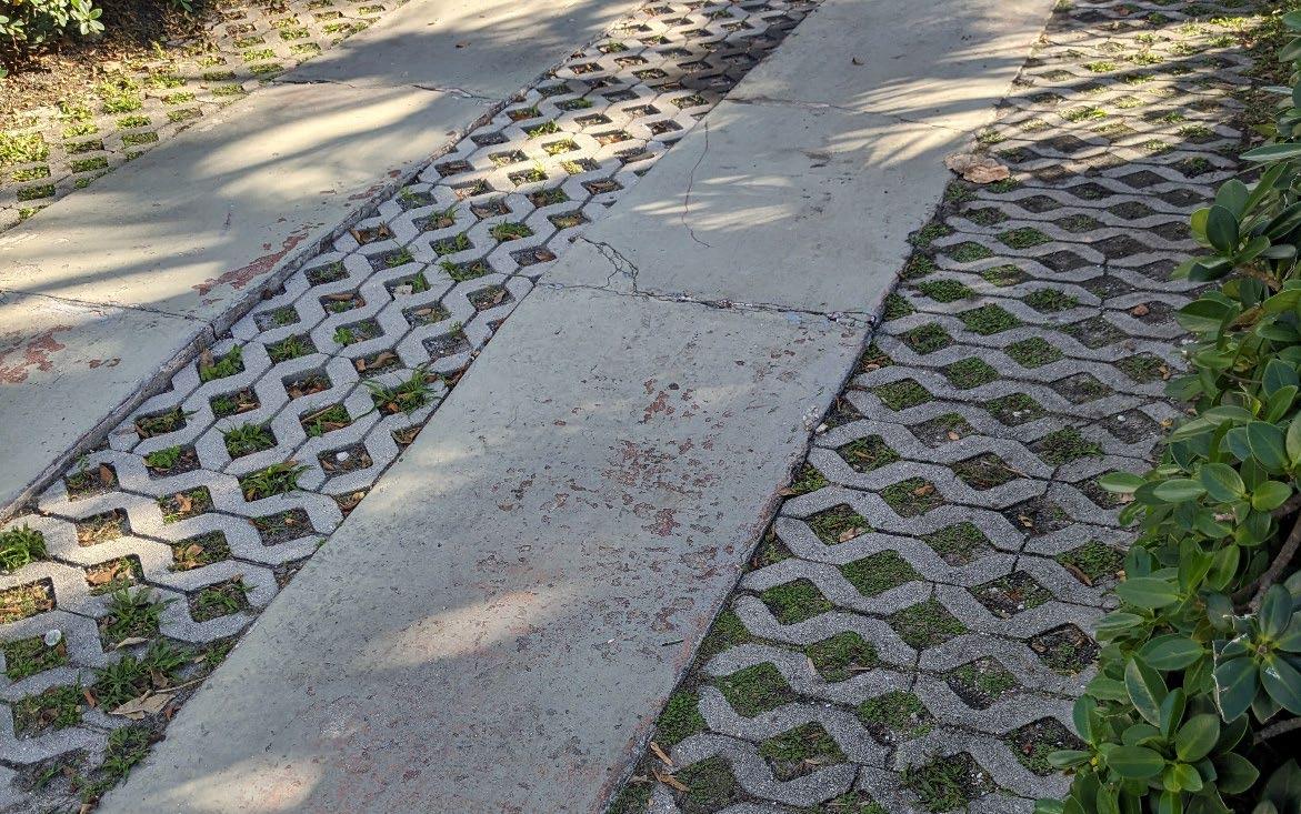
1155-01: Graphic showing paving materials for a residential driveway. In this example, the main drive treads were paved in concrete, whereas the adjacent areas were paved using concrete pavers that allow for some stormwater infiltration a “stormwater-wise” technology.
§1155.11 BICYCLE PARKING. Parking spaces for bicycles and similar objects is permitted as an accessory to any use and may be located in any location on any lot in any district, provided it does not cause an obstruction to ingress, egress, or the safe passage of pedestrians.
§1155.12
PARKING OF COMMERCIAL VEHICLES. The parking of a commercial vehicle or fleet vehicle is treated similarly to the parking of any personal vehicle, except that no lot containing a residential use shall permit the parking of more than one commercial vehicle per dwelling unit.
City of Garfield Heights, Ohio, Planning and Zoning Code
>Title Four | Generally Applicable Regulations
>>Chapter 1155: Parking Standards
§1155.13 TEMPORARY STORAGE OF INOPERABLE VEHICLES. The temporary storage of inoperable vehicles shall be limited to one inoperable vehicle per lot and shall be stored on a paved surface; however, a vehicle-oriented use (such as a car sales use or car rental operation) shall be permitted to store more than one inoperable vehicle per lot where such storage is temporary. For the purposes of this regulation, “temporary” shall be interpreted to mean six months or less in duration; and “permanent” shall be interpreted to mean more than six months in duration.
§1155.14 STORMWATER DISCHARGE FROM PARKING AREAS. Off-street parking areas shall not discharge stormwater to adjacent properties, adjacent roadways, or storm sewer systems; all stormwater discharge from off-street parking facilities must be directed to on-site detention basins, rain gardens, or dry wells.
§1155.15 PARKING SPACE MARKING OR PAINTING. Designated parking spaces shall be marked on the surface of the parking area with paint or permanent marking materials and maintained in a clearly visible condition.
§1155.16 WHEEL STOPS. Any parking space that (1) is associated with any use other than a one-unit or two-unit dwelling and that (2) has a front or a rear end that abuts the perimeter of the parking area (or perimeter landscaping strip) must be equipped with a wheel stop. Each wheel stop shall be a singular block of durable material with a maximum height of six inches and a maximum length of eight feet. Wheel stops are to be securely fastened to the ground and located no less than two feet from the perimeter of the parking area and no less than four feet from any structures, buildings, walls, or plant material, excluding ground cover.
§1155.17 ADA-COMPLIANT PARKING. For every use, except one-unit dwellings and two-unit dwellings, accessible parking spaces shall be provided as required in the Americans with Disabilities Act Section 208 and Section 502. The Americans with Disabilities Act can be reviewed at the United States Access Board website.
§1155.18 PARKING OF RECREATIONAL VEHICLES
(A) Definitions. The definition of Recreational Vehicle may be found in Title Nine "Glossary of Terms” of this Planning and Zoning Code.
(B) If the recreational vehicle is parked outside of a garage, it shall be parked no less than ten feet from the front property line, and no less than three feet from any other property line.
(C) The number of recreational vehicles parked outside any enclosed structure shall be limited to two, with not more than one located in the front yard.
(D) Recreational vehicles shall be parked on a fully improved and legally installed driveway in a front, rear or side yard, or on paver-bricks or similar material in a side or rear yard.
§1156.01 PURPOSE OF VISION CLEARANCE TRIANGLE. These vision clearance triangle standards are intended to reduce visual obstructions and mitigate the dangers associated with motor vehicles turning onto streets and to advance the government’s interests in public health and safety.
City of Garfield Heights, Ohio, Planning and Zoning Code
>Title Four | Generally Applicable Regulations
>>Chapter 1156: Vision Clearance Triangle Standards
§1156.02 APPLICABILITY. These vision triangle clearance standards shall apply at any street-and-street intersection and any street-and-driveway intersection.
§1156.03 VISION CLEARANCE TRIANGLE DEFINITION. The definition of Vision Clearance Triangle may be found in Title Nine "Glossary of Terms” of this Planning and Zoning Code.
§1156.04 VISION TRIANGLE TO REMAIN CLEAR. No structure, vegetation, sign, or other visual obstruction shall be placed within the vision triangle except where the structure, vegetation, or sign fulfills one of the following conditions:
(A) The structure, vegetation, or sign does not exceed three feet of height above the crest of the driveway or the street with a more minor classification at a street-and-street intersection;
(B) The structure, vegetation, or sign presents a visual obstruction of a pole-type nature, such as a support beam or a tree trunk, where the obstruction is less than one foot in diameter.
§1156.05 EXCEPTION FOR UNIMPROVED ALLEYS. No vision clearance triangle is required to remain cleared for unimproved or unpaved alleys.
§1157.01
(A) No fence shall be erected, altered, relocated or reconstructed upon, along or adjacent to any boundary line of any lot or parcel of land or part thereof, in the City without first obtaining a permit therefor. No permit shall be issued without the applicant first presenting to the Building Commissioner a survey of the parcel of land sought to be enclosed by the fence or in the alternative, an agreement between all persons of interest, contiguous to such parcel of land being enclosed, expressing their agreement and consent to the location of such fence upon the applicant's parcel of land. Where a fence is proposed to be erected, altered, relocated, or reconstructed within the front yard area of a lot, such action on such portion of the fence shall require express permission from the Planning and Zoning Commission.
(B) No fence shall be erected or constructed between the rear building line and the street or sidewalk except as hereinafter provided.
(i) An extension of a fence shall be allowed one foot beyond the side door of a dwelling from the back building line, with a gate, provided that the dwelling does not have a rear entrance and that such side door shall be a direct means of entrance into the home. A side door on attached garages as an entrance shall not be considered for the purposes of this section.
(ii) The Building Commissioner shall only permit the extension provided for in. subsection (ii)(1) hereof, when in his determination, the extension of fence from the rear building line to one foot beyond the side door shall not constitute a hardship to the adjoining property owner.
City of Garfield Heights, Ohio, Planning and Zoning Code
>Title Four | Generally Applicable Regulations 96
>>Chapter 1157: Fence Standards
(iii) Split rail or picket fences, not exceeding 3 feet in height, shall be permitted within the front yard, but set back at least 25 feet from the right-of-way line of a property, so long as the fence will not obstruct the view of pedestrians or operators of motor vehicles intending to enter a street, alley, sidewalk or other passageway, and are not constructed across the entire front nor the entire side of the front yard.
(C) Construction: The face of the fence is to be on the outside, and on the lot or land of the person constructing or causing the construction of such fence. The height of the fence shall be measured from the surface of the ground, undisturbed by fills, in relation to adjoining property. Where the land is uneven, with depressions and ridges, the Building Commissioner shall determine the average or mean level of the ground.
(D) Vinyl Privacy Fences: Solid vinyl fences shall be permitted.
(E) Wooden Privacy Fences: Only the following wooden fences shall be permitted within the residential districts of the City of Garfield Heights.
(i) Board on Board Fence or Shadow Box Fence: A fence constructed with a row of boards placed upright or horizontally on opposite sides of a supporting beam. The individual boards on the same side of the supporting beam shall be separated by a distance that equals or is less than the width of the board.

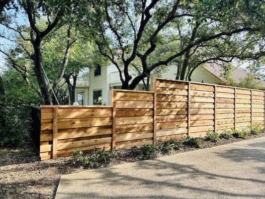
(ii) Basket Weave Fence or Woven Fence: A fence made of interwoven strips or slats of flexible or semi-flexible material in which the pattern has the appearance of a plaited basket.
City of Garfield Heights, Ohio, Planning and Zoning Code
>Title Four | Generally Applicable Regulations
>>Chapter 1157: Fence Standards

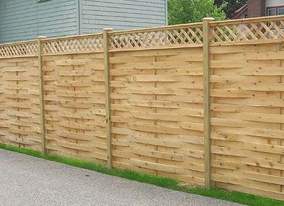
(iii) Solid Board: A fence constructed with a row of boards no less than four inches in width, but no more than six inches in width, placed upright and against each other.


(iv) Chain Link Fences: Shall be permitted so long as the fence is made of metal consisting of loops of wire interconnected in a series of joined links
(v) Ornamental Fences: The following ornamental fences shall be permitted within the residential districts of the City of Garfield Heights: Split Rail Fences, Post and Board Fences, Picket Fences, Wrought Iron Fences, and Decorative Fences.
(vi) Fences Not Permitted:
(1) Plywood Fences: No fence constructed in total or in portion of plywood shall be permitted.
(1) Stockade Fence or Palisade Fence: No fence constructed with a row of large, pointed stakes placed upright and against each other shall be permitted.
City of Garfield Heights, Ohio, Planning and Zoning Code
>Title Four | Generally Applicable Regulations
>>Chapter 1157: Fence Standards
(2) Poultry-Netted Fences: No fence constructed in total or in portion of poultry-net/chicken wire.
(A) For fence height restrictions in the front yard, refer to the above §1157.01(B)
(B) Fences along the side lines of residential lots may extend to six feet in height provided that all adjoining property owners sign an agreement as to the height of such fence(s).
(C) Fences along the rear lot lines of residential lots shall not exceed a height of six feet.
(D) Fences along the rear and/or side lot lines of residential lots abutting or adjacent to retail, commercial or industrially zoned areas shall not exceed a height of seven feet.
(E) Fences along the rear or side lines of properties zoned retail, commercial or industrial, which are not abutting or adjacent to residential properties, shall not exceed a height of eight feet.

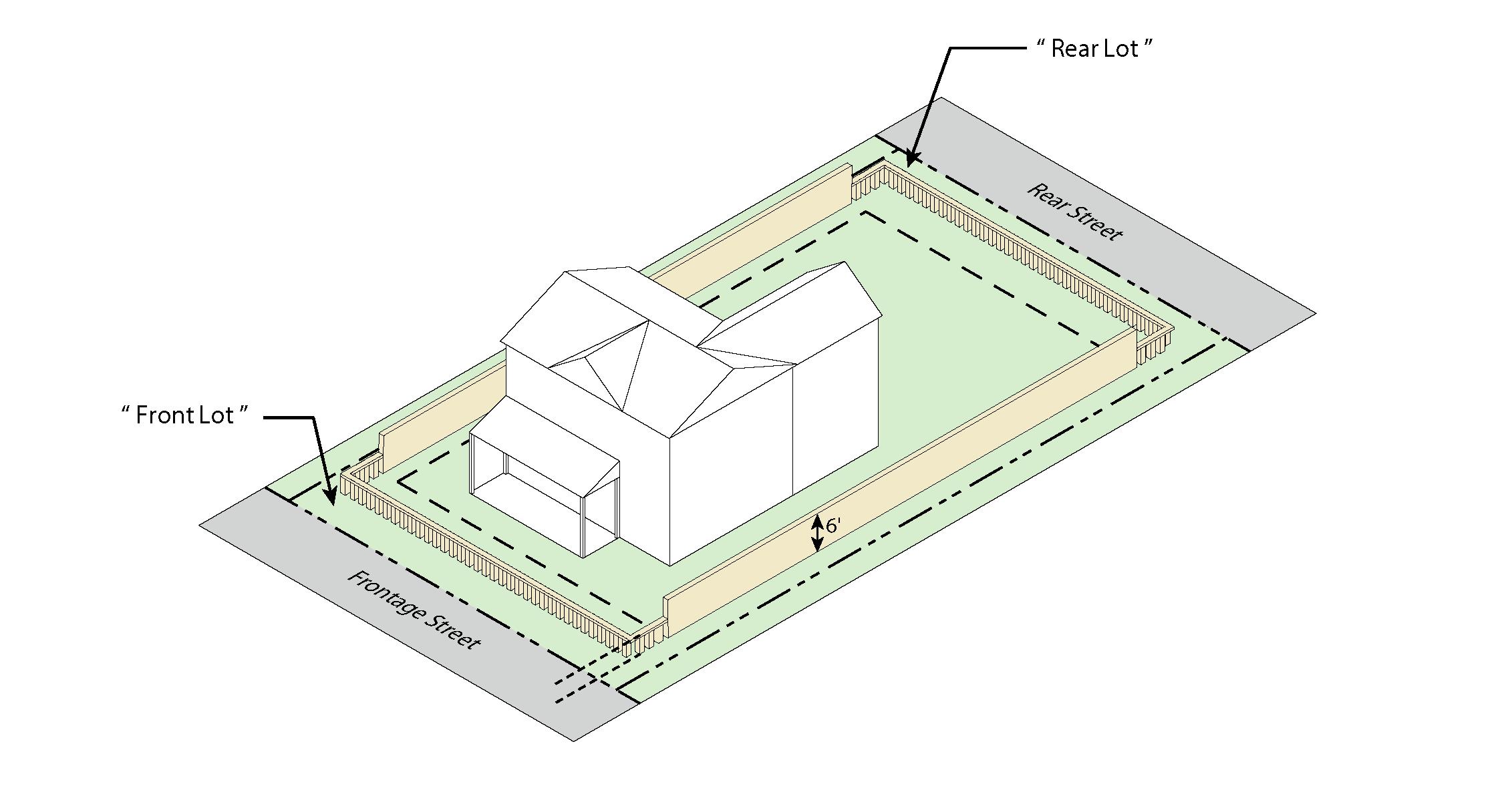
Figure 1157-04: Graphic showing fence height maximums permitted in the front yard versus the side yard and rear yard. Fence heights in the front yard are regulated by §1157.01(B) In this particular example, a shorter fence is supplied in the rear yard, as this lot is a “double frontage” lot and fronts two rights-of-way.
City of Garfield Heights, Ohio, Planning and Zoning Code
>Title Four | Generally Applicable Regulations
>>Chapter 1157: Fence Standards
§1157.03 BARBED WIRE FENCES
(A) Barbed wire in fences shall not be permitted where the adjacent property is residential.
(B) Where barbed wired is not prohibited, such wire shall be not less than seven feet above the ground.
§1157.04 PERMIT FEES. Fees for fence permits shall be charged at the rate provided under the fee schedule in the Building Code.
§1157.05 WAIVERS FOR SWIMMING POOLS AND RESTORATION. A resident who has been extended a fence waiver of any type in conjunction with the construction or maintenance of a swimming pool whether such waiver has been granted by City Council or by the Board of Zoning Appeals, shall in the event the swimming pool is abandoned or removed, be required within thirty days thereof, to restore the height of all fencing in compliance with this chapter. All waivers issued in connection with swimming pool fences, whether by City Council or by the Board of Zoning Appeals shall from the date of passage of this section bear the notation. "This waiver is issued only for the life of the swimming pool. In the event the swimming pool is abandoned or removed, all fences shall be restored to height provided in ordinances of this City within thirty days thereof."
§1157.06 PROHIBITED FENCES
(A) No fence shall be erected or constructed parallel to another fence in a manner that would cause less than three feet of property to exist between the two fences. Said property between the two fences must be maintained in accordance with Garfield Heights Code Section 1359 “Exterior Property Maintenance Code.” When applying for a fence permit, failure to inform the Building Department or the Building Commissioner of the condition of a parallel fence will result in the negation of any permit issued by the City
(B) Dog pens or enclosures inside fenced-in properties are prohibited.
(C) No fence shall be erected or constructed on a corner lot property unless said fence is erected or constructed two feet from, and inside of, a public sidewalk or walkway.
§1158.01 APPLICABILITY OF THESE SCREENING AND BUFFER ZONE STANDARDS. These screening and buffer zone standards are meant to add to, not replace, the requirements for parking area landscaping (see §1155.07) and for fences (see Chapter 1157).
§1158.02 PURPOSE OF SCREENING AND BUFFER ZONE REQUIREMENTS. The purpose of this Chapter is to provide for visual screening or landscape buffers to remove, reduce, lessen or absorb the shock impact between one incompatible use or zone; breakup and lessen impact of large parking areas; provide interest and lessen the monotony of the streetscape; and obscure the view of outdoor rubbish areas, dumpsters and loading areas. In addition to any required screening or landscaping, all pervious areas of the sites that are subject to this section shall be permanently protected from soil erosion with grass or other suitable ground cover.
City of Garfield Heights, Ohio, Planning and Zoning Code
>Title Four | Generally Applicable Regulations
>>Chapter 1158: Screening and Buffer Zone Standards
100
§1158.03 DEFINITIONS. The definitions of the terms Standard Screening, Standard Plant, Standard Shrub, and Standard Tree may be found in Title Nine "Glossary of Terms” of this Planning and Zoning Code.
§1158.04 REQUIRED BUFFER ZONE. In addition to any other landscaping requirements that may be set forth in this Planning and Zoning Code, all conditional uses in Non-Residential Districts, and all lots in Non-Residential Districts that abut Residential Districts shall be required to provide a buffer zone along the entire length of the common boundary between the Non-Residential use/district and the Residential District’s lot(s), and shall be maintained not less than ten feet in depth. This buffer zone shall be landscaped with grass, Standard Shrubs and Standard Trees, and shall contain a solid brick wall three feet in height from the building line of the adjacent residential use or district to the street and six feet in height from the building line to the rear yard line of the abutting residential use or district, whichever is greater.
§1158.05 MAINTENANCE OF APPROVED LANDSCAPING. For uses that require an approved landscaping plan, landscaped areas shall be maintained in a fully landscaped condition essentially matching the approved landscaping plan on file with the City, with dead plants being promptly replaced. Any non-residential property for which no landscaping plan has been approved, as a result of being used before this section was adopted, or any other section requiring landscaping, shall continue to maintain existing trees, shrubs and other landscaping to fulfill the purposes of this section as specified hereinabove.
§1159.01 All outdoor lighting shall be of constant intensity, and shall be downward directed, reflected or shielded so as not to be of excessive brightness or cause glare hazardous to pedestrians or drivers, create a nuisance, or unreasonably interfere with a neighboring property owner’s right to enjoy his property.
§1159.02 To this end and to minimize light trespass:
(A) All sources of illumination of the exterior of buildings or grounds shall be shielded so as not to cause direct glare and shall be directed away from any lot lines and toward the principal building and parking area on a lot. Lighting fixtures and devices from which direct glare is visible on adjoining roads or property shall be prohibited.
(B) All sources of illumination of the exterior of buildings or grounds shall be shielded so as not to cause glare which is hazardous to vehicle drivers or is objectionable to owners of adjacent lots.
(C) Lighting fixtures with lamps rated at initial lumens of 2,500 or greater must be the full cutoff type. For purposes of this regulation, a full cutoff light fixture is defined as one which emits no light above a horizontal plane drawn through the lowest part of the fixture.
(D) Light fixtures used to illuminate flags, statues, or any other objects mounted on a pole, pedestal, or platform, shall use a narrow cone beam of light. Only one fixture with a lamp emitting no more than 1,800 lumens shall be used for each flag, statue, or other object illuminated.
City of Garfield Heights, Ohio, Planning and Zoning Code
>Title Four | Generally Applicable Regulations 101
>>Chapter 1159: Outdoor Lighting Standards
(E) Flashing lights shall be prohibited.
(F) When used for security purposes or to illuminate walkways, driveways and storage areas, roadways, equipment yards and parking lots, only fully shielded cut-off style light fixtures shall be utilized.
(G) All outdoor light pole fixtures shall not exceed a maximum height of 20 feet. Where taller lighting fixtures are needed, such as to illuminate a football field, a variance shall be required.
§1159.03 Exemptions to These Regulations
(A) All outdoor lighting fixtures producing light directly by the combustion of fossil fuels, such as kerosene lantern or gas lamps, are exempt from the fully shielded, cut-off requirements above.
(B) All low-voltage lighting rated 12 volts or less and seasonal lighting shall be exempt from the requirements above.
§1160.01 Recycling and trash receptacles shall be screened on all sides from any residential district, parking area or public right-of-way by a vision obscuring fence or plant material.
§1160.02 Whenever outdoor storage is permitted, the storage area shall be totally enclosed by fencing in compliance with this Planning and Zoning Code. Whenever rubbish areas or dumpsters or similar structures are stored outside, they shall be screened with Standard Screening, in compliance with this Planning and Zoning Code, except that the height of such fence, wall or hedge shall be at least one foot higher than the structure or material being stored unless the Planning Commission determines that such screening is not necessary due to other site conditions on the property where the storage will occur or the existing or foreseeable uses of surrounding properties. The Planning Commission may permit the fence to be substituted by a masonry wall or evergreen hedge, or other landscaping, when it determines that such wall or landscaping will provide at least as good a screen as fencing would provide for surrounding property.
For regulations applicable to signs, including outdoor advertising signs, billboards, political campaign signs, for-sale signs, temporary signs, and others, please refer to Title Five "Sign Regulations” of this Planning and Zoning Code.
For environmental standards, including riparian setback standards, hillside protection standards, stormwater management standards, erosion and sediment control standards, illicit discharge controls, and floodplain damage reduction standards, see Title Six “Environmental Regulations.”
City of Garfield Heights, Ohio, Planning and Zoning Code
>Title Four | Generally Applicable Regulations 102
>>Chapter 1160: Dumpsters and Outdoor Storage Standards
These sign standards are intended to regulate the time, place, and manner of signs in order to advance the governmental interests of neighborhood aesthetics and safety of pedestrians and drivers.
The definition of a sign may be found in Title Nine "Glossary of Terms” of this Planning and Zoning Code.
§1165.01 These sign standards shall apply to all signs in the city that have content that is visibly discernable from the public right-of-way.
§1165.02 However, these sign standards shall not apply to the following signs, provided that such signs do not cause glare, safety, or health concerns for the users of nearby private properties:
(A) Signs that have content that is visibly discernable only from private premises;
(B) Signs of less than two square foot each in sign area, where such signs are not used together to effectively constitute a larger sign (also known as “incidental signs” by this Planning and Zoning Code);
(C) Signs etched into cornerstones or masonry of buildings;
(D) Signs etched into cemetery headstones in a cemetery or in a cemetery headstone sales lot;
(E) Signs upon vending machines totaling less than 20 square feet per lot;
(F) Signs upon umbrellas in outdoor dining areas; and
(G) Signs comprising the exterior paint of a vehicle, where such a vehicle is currently registered and in operable condition and where such signs are not illuminated.
City of Garfield Heights, Ohio, Planning and Zoning Code
>Title Five | Sign Regulations
>>Chapter 1163: Purpose of Sign Regulations
§1166.01 SIGN TYPES REQUIRING A ZONING PERMIT. No sign shall be erected, relocated, expanded, made higher, or replaced or changed in illumination type, without a valid zoning permit issued by the City. This requirement shall not apply to the maintenance of an existing sign where such maintenance does not require its relocation, expansion, or replacement. This requirement shall not apply to temporary signs, as described as not requiring a zoning permit in the subsection below; and this requirement shall not apply to those signs under which these sign standards do not apply, as described in Chapter 1165 “Applicability of Sign Standards”.
§1166.02 SIGN TYPES NOT REQUIRING A ZONING PERMIT
(A) Temporary signs, as defined in this code, shall not require a zoning permit in order to be erected, provided that they conform to the sign standards of this section, including maximum sign size, maximum sign height, and specific sign material and location regulations, and provided that they do not occupy the public right-of-way.
(B) Incidental signs shall not require zoning permits; for the purposes of this code, an incidental sign shall be defined as a sign of less than two square feet, with or without illumination, that is not part of a larger array of signs that, when combined, form one cohesive sign; an address number, a “handicapped parking” sign, a “no trespassing” sign, and an “open” sign are examples of an incidental sign. An incidental sign may not include illumination that blinks or twinkles; an incidental sign may not include scrolling text or a screen or similar device that has movement effects.
§1166.03 APPLICATION REQUIREMENTS FOR ZONING PERMITS. Applicants for a zoning permit for the erection or modification of a sign should refer to Title Seven "Administration and Procedures”.
§1166.04 PROHIBITED SIGNS. The following sign types shall be prohibited as both permanent signs and temporary signs for all land uses in all districts:
(A) Air-activated signs or cold-air inflatable balloon signs;
(B) Festoons, as defined herein, except during recognized holiday periods or seasonal festivals or special community events during which the outdoor display of decorations is encouraged or is customary
(C) Flashing signs, as defined herein, or signs containing strobe lights;
(D) Search-light or spot-light signs;
(E) Moving signs, as defined herein, other than flags;
(F) Signs in the public right-of-way, except that temporary sandwich board signs, wall signs, and projecting signs may be expressly permitted in the public right-of-way; and
(G) Signs that violate any City regulation on emission of noise, odor, or particulate or gaseous matter.
City of Garfield Heights, Ohio, Planning and Zoning Code
>Title Five | Sign Regulations
>>Chapter 1166: Obtaining a Permit for a Sign
The area of a sign face, which is also the sign area of a wall sign or other sign with only one face, shall be computed by means of the smallest square, circle, rectangle, triangle, or combination thereof that shall encompass the extreme limits of the writing, representation, emblem, or other display, together with any material or color that is an integral part of the background of the display or used to differentiate the sign from backdrop or structure against which it is placed. This does not include any supporting framework, monument, bracing, or decorative fence or wall when such fence or wall meets the standards of this Code. On a two-sided sign, such as a projecting sign, the sign area shall be computed as the area of only one of the sides.
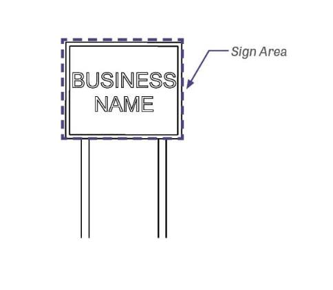

Sign height shall be measured as the vertical distance from the highest part of a sign, including support structures and embellishments, to: (a) the mean average grade of the land or level of the roof in the case of a roof sign abutting the base of or directly beneath the sign, for facade signs; awning and canopy signs; roof signs; projecting signs; and ground signs more than 50 feet from the edge of a public street pavement; or (b) the curb level, as defined herein, of the street from which the sign is intended to be viewed, for all other ground signs; or, in the case of a lot abutting more than one street, the mean average of the curb levels of such streets.
City of Garfield Heights, Ohio, Planning and Zoning Code
>Title Five | Sign Regulations
>>Chapter 1167: Measuring Sign Area
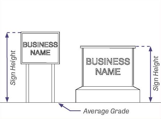

1168-01: Graphic showing the sign height for a freestanding sign (left) and a monument sign (right).
Both permanent and temporary freestanding and projecting signs shall be set back from the street pavement as necessary to comply with the restrictions on obstructions within vision clearance triangles, as described in Chapter 1156 “Vision Clearance Triangle Standards”.
§1170.01 SIGN ILLUMINATION DEFINED. The definition of sign illumination may be found in Title Nine "Glossary of Terms” of this Planning and Zoning Code.
§1170.02 PROHIBITED SIGN ILLUMINATION TYPES. The following sign illumination types shall be prohibited in all districts:
(A) Sign illumination that causes glare to neighboring properties, vehicles, or pedestrians, such as bare-bulb illumination that is not properly shielded or diffused; and
(B) Sign illumination that blinks, shudders, or twinkles, or in any way is not constant and even in intensity and direction.
§1170.03 SIGN ILLUMINATION PERMITTED ONLY WHERE SPECIFICALLY LISTED No sign illumination may be employed except where expressly listed on the applicable sign table (see sections under Chapter 1177 “Sign Types and Tables of Permissions”).
City of Garfield Heights, Ohio, Planning and Zoning Code
>Title Five | Sign Regulations
>>Chapter 1169: Signs in the Vision Clearance Triangle
A legally erected sign is allowed to manually change its copy through the use of re-pasting, repainting, refabrication, or other manual means. However, where the copy is changed remotely or through computercontrolled programs, such as in the case of LCD or LED screen-type signs, the sign shall be considered an electronic display sign and shall be regulated by Chapter 1172 “Electronic Display Sign Standards.”
Signs with electronically controlled displays shall conform to all of the following standards:
§1172.01 NO ANIMATION IS ALLOWED. Flashing, blinking, fluttering, cascading, swiping, flying, swirling, or other visual effects are prohibited.
§1172.02 MINIMUM DISPLAY TIME. Each sign copy shall be “still-frame” and shall be displayed for a minimum of 15 seconds.
§1172.03 COLOR. No white, ivory, or yellow backgrounds are allowed to avoid night-time light pollution and its associated health and safety effects.
§1172.04 BRIGHTNESS. The sign shall not exceed 500 nits between dusk and dawn, and the intensity of illumination shall not change.
Some signs may be desirable within or over the public right-of-way, such as in the case of a marquee sign projecting over a sidewalk, a sandwich board sign occupying the sidewalk outside of a café, or a wall sign that projects 8 inches from the face of a building with no setback from the public right-of-way. No sign may occupy the public right-of-way, including above the public right-of-way, without express permission from the City, typically indicated on the zoning permit.
Nothing in this section shall prohibit the maintenance of an existing sign, including the rewiring, repainting, change of copy, or reinforcement of structural elements, where such maintenance does not constitute a relocation, change in height, or enlargement of the sign and where such maintenance does not constitute a change of sign illumination type. Signs shall be maintained in a safe, working, and clean condition by the landowner. Signs which are deemed by the City to be dangerous to public health and safety shall be ordered by the City to be removed immediately at the landowner’s expense.
The replacement of an existing permitted or legal nonconforming sign shall be permitted where the replacement constitutes no change in sign type, sign area, sign location and height, or sign illumination type.
City of Garfield Heights, Ohio, Planning and Zoning Code
>Title Five | Sign Regulations
>>Chapter 1171: Changing Sign Copy or Messaging
Existing signs which were erected legally prior to the enactment of this code but which do not conform to the sign standards of this code shall be deemed legal nonconforming signs. Likewise, signs deemed nonconforming by the previously enforced development code shall be considered legal nonconforming signs by this code. However, a sign which is nonconforming for its use of nonconforming changeable copy animations, for its use of illumination that causes unhealthful glare on adjacent properties or passersby, or for its lack of maintenance in a safe, working, and clean condition shall not be considered a legal nonconforming sign and shall be made to conform to those standards or be deemed a violation.
A legal nonconforming sign shall be allowed to continue to exist including the changing of copy; the maintenance of the sign face, wiring, and structure; and the replacement of the sign provided that no change is made to the sign type, sign area, sign height, sign location, and sign illumination type. However, where the City determines that the sign poses a danger to public health or safety, it may order that the sign be removed or reinforced in order to mitigate such danger.
Where a legal nonconforming sign is removed by order of the City due to it being a danger to public health or safety or where a legal nonconforming sign is destroyed by calamity, a sign of exact area, location, height, type, and illumination type may be erected within 12 months of the date of removal or destruction, regardless of whether it meets this code’s sign standards, provided that the new sign does not present a danger to public health or safety, as determined by the City. The replacement sign shall be deemed a legal nonconforming sign by this code. Where the sign is not replaced within 12 months of the date of removal or destruction, the sign shall be considered to be abandoned by intent, and the legal nonconforming status shall be stripped from the sign.
City of Garfield Heights, Ohio, Planning and Zoning Code
>Title Five | Sign Regulations
>>Chapter 1176: Nonconforming Signs
In the following sections, sign types are permitted by zoning district.
§1177.01 TEMPORARY SIGN STANDARDS
(A) Definition. The definition can be found in Title Nine "Glossary of Terms” of this Planning and Zoning Code.


1177-01: Graphic showing a temporary sign in this case, an A-frame or “sandwich board” sign.
(B) Permitting. A zoning permit is not required to erect a temporary sign. Please note that temporary signs in the public right-of-way, such as sandwich board signs (i.e., A-frame signs) displayed on a public sidewalk, shall be permitted only with written City approval.
(C) Standards. No temporary sign shall be displayed except in accordance with the table below.
City of Garfield Heights, Ohio, Planning and Zoning Code
>Title Five | Sign Regulations
>>Chapter 1177: Sign Types and Tables of Permissions
and Rear Setback of Sign
City of Garfield Heights, Ohio, Planning and Zoning Code
>Title Five | Sign Regulations
>>Chapter 1177: Sign Types and Tables of Permissions
(A) Definition. The definition can be found in Title Nine "Glossary of Terms” of this Planning and Zoning Code.

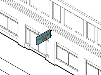
(B) Permitting. A zoning permit is required to install or enlarge a projecting sign or to change the illumination associated with a projecting sign. Changing the content on a projecting sign shall not require a zoning permit. The act of applying for a projecting zoning permit for a projecting sign that hangs over the public right-of-way shall be interpreted by the City as applying for a public right-of-way encroachment permit; when issuing a permit, the City shall indicate whether the projecting sign shall be permitted to overhang the public right-of-way and shall detail any necessary requirements on such encroachment. Where an encroachment of the public right-ofway is permitted by the City for a particular sign on a particular lot, the encroachment permit shall be interpreted as nullifying the minimum front setback in the table below.
(C) Standards. No projecting sign shall be displayed except in accordance with the table below.
City of Garfield Heights, Ohio, Planning and Zoning Code
>Title Five | Sign Regulations
>>Chapter 1177: Sign Types and Tables of Permissions
and Rear Setback
Notes. Asterisk (*) indicates that, for a lot on a corner or multiple corners, such number of signs per lot per sign type shall be interpreted as per street frontage; therefore, a lot on the corner of two streets shall be permitted twice the normal number of that sign type, provided that half of the permitted signs are installed on one frontage and the other half of the permitted signs are installed on the other frontage.
City of Garfield Heights, Ohio, Planning and Zoning Code
>Title Five | Sign Regulations
>>Chapter 1177: Sign Types and Tables of Permissions Projecting Sign Standards
(A) Definition. The definition can be found in Title Nine "Glossary of Terms” of this Planning and Zoning Code.

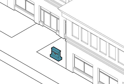
(B) Permitting. A zoning permit is required to install or enlarge a freestanding sign or to change the illumination associated with a freestanding sign. Changing the content on a freestanding sign shall not require a zoning permit.
(C) Standards. No freestanding sign shall be displayed except in accordance with the table below.
Setback of
and Rear Setback of
Notes. Asterisk (*) indicates that, for a lot on a corner or multiple corners, such number of signs per lot per sign type shall be interpreted as per street frontage; therefore, a lot on the corner of two streets shall be permitted twice the normal number of that sign type, provided that half of the permitted signs are installed on one frontage and the other half of the permitted signs are installed on the other frontage.
City of Garfield Heights, Ohio, Planning and Zoning Code
>Title Five | Sign Regulations
>>Chapter 1177: Sign Types and Tables of Permissions
(A) Definition. The definition can be found in Title Nine "Glossary of Terms” of this Planning and Zoning Code.

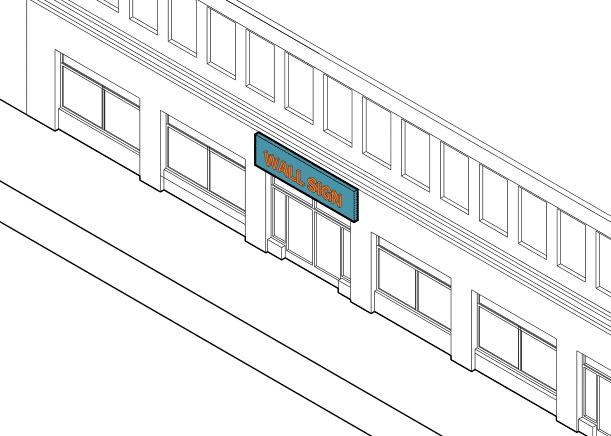
(B) Permitting. A zoning permit is required to install or enlarge a wall sign or to change the illumination associated with a wall sign. Changing the content on a wall sign shall not require a zoning permit.
(C) Standards. No wall sign shall be displayed except in accordance with the table below.
City of Garfield Heights, Ohio, Planning and Zoning Code
>Title Five | Sign Regulations
>>Chapter 1177: Sign Types and Tables of Permissions
In Association with Which Land Uses? Non-Residential Uses or 9-Plus-Unit Residential Uses
Sign Illumination Types
Notes. Asterisk (*) indicates that, for a lot on a corner or multiple corners, such number of signs per lot per sign type shall be interpreted as per street frontage; therefore, a lot on the corner of two streets shall be permitted twice the normal number of that sign type, provided that half of the permitted signs are installed on one frontage and the other half of the permitted signs are installed on the other frontage.
City of Garfield Heights, Ohio, Planning and Zoning Code
>Title Five | Sign Regulations
>>Chapter 1177: Sign Types and Tables of Permissions
(A) Definition. The definition can be found in Title Nine "Glossary of Terms” of this Planning and Zoning Code.

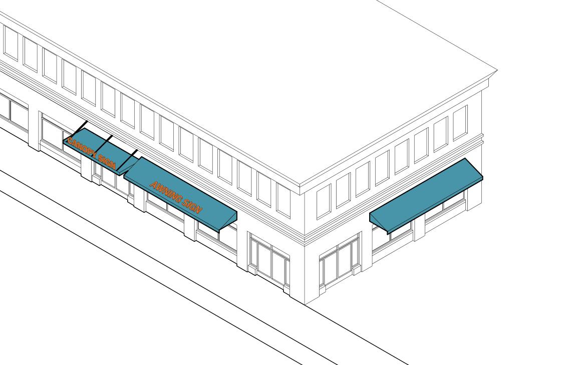
(B) Permitting. A zoning permit is required to install or enlarge a canopy or awning sign or to change the illumination associated with a canopy or awning sign. Changing the content on a canopy or awning sign shall not require a zoning permit. The act of applying for a canopy or awning zoning permit for a canopy or awning sign that hangs over the public right-of-way shall be interpreted by the City as applying for a public right-of-way encroachment permit; when issuing a permit, the City shall indicate whether the canopy or awning sign shall be permitted to overhang the public right-ofway and shall detail any necessary requirements on such encroachment. Where an encroachment of the public right-of-way is permitted by the City for a particular sign on a particular lot, the encroachment permit shall be interpreted as nullifying the minimum front setback in the table below.
(C) Standards. No canopy or awning sign shall be displayed except in accordance with the table below.
City of Garfield Heights, Ohio, Planning and Zoning Code >Title Five | Sign Regulations
Notes. Asterisk (*) indicates that, for a lot on a corner or multiple corners, such number of signs per lot per sign type shall be interpreted as per street frontage; therefore, a lot on the corner of two streets shall be permitted twice the normal number of that sign type, provided that half of the permitted signs are installed on one frontage and the other half of the permitted signs are installed on the other frontage.
City of Garfield Heights, Ohio, Planning and Zoning Code
>Title Five | Sign Regulations
>>Chapter 1177: Sign Types and Tables of Permissions
(A) Definition. The definition can be found in Title Nine "Glossary of Terms” of this Planning and Zoning Code.

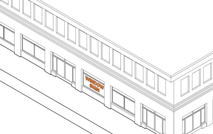
(B) Permitting. A zoning permit is required to install or enlarge a window sign. Changing the content of a window sign shall not require a zoning permit.
(C) Standards. No window sign shall be displayed except in accordance with the table below.
City of Garfield Heights, Ohio, Planning and Zoning Code
>Title Five | Sign Regulations
>>Chapter 1177: Sign Types and Tables of Permissions
Setback of Sign
and Rear Setback of
Notes. Asterisk (*) indicates that, for a lot on a corner or multiple corners, such number of signs per lot per sign type shall be interpreted as per street frontage; therefore, a lot on the corner of two streets shall be permitted twice the normal number of that sign type, provided that half of the permitted signs are installed on one frontage and the other half of the permitted signs are installed on the other frontage.
City of Garfield Heights, Ohio, Planning and Zoning Code
>Title Five | Sign Regulations
>>Chapter 1177: Sign Types and Tables of Permissions
§1178.01 PURPOSE OF MURAL REGULATIONS. This Planning and Zoning Code treats murals, a type of sign, differently than most other signs murals celebrate or comment on the community’s cultural heritage, enhance the quality of life, and important in place-making, which is a community imperative.
§1178.02 DEFINITION. The definition can be found in Title Nine "Glossary of Terms” of this Planning and Zoning Code.
§1178.03 MURAL STANDARDS
(A) Murals shall use durable, exterior-grade paints and materials and shall use weatherproof and ultraviolet-protective coatings;
(B) Murals shall not obscure character-defining architectural features of a building, such as cornices, archways, or columns, although some murals may imitate or enhance architectural features, such as illustrating columns where no columns exist;
(C) Murals may create the illusion of 3 dimensionality, but they shall not be built out from the building face except where disguising mechanical features, such as electric conduit or other utilities;
(D) Murals shall not be permitted on brick surfaces that were, at the time of brick manufacture and building erection, designed to remain unpainted, such as low-fire bricks that require moisture permeability, and such as scratched bricks;
(E) Murals shall not include obscene language or graphics. The Zoning Administrator shall determine whether the content of a proposed mural is obscene, and appeals to the Zoning Administrator’s decision shall be heard by the Zoning Board of Appeals.
(F) No mural shall include the logo or name of a commercial enterprise nor the logo or name of a brand sold or serviced by a commercial enterprise where such mural is located on the wall of a structure owned by such commercial enterprise or where such mural is located on a wall of a structure within 50 feet of such commercial enterprise. For instance, a mural that includes the logos of Nike and Adidas on the wall of an athletic clothing store shall be considered in violation of this provision. However, a mural showing fruit and vegetables on the wall of a grocery store, where no name of the grocer nor the name of the fruit producer is indicated, shall be in conformity with this provision.
City of Garfield Heights, Ohio, Planning and Zoning Code
>Title Five | Sign Regulations
>>Chapter 1178: Mural Standards

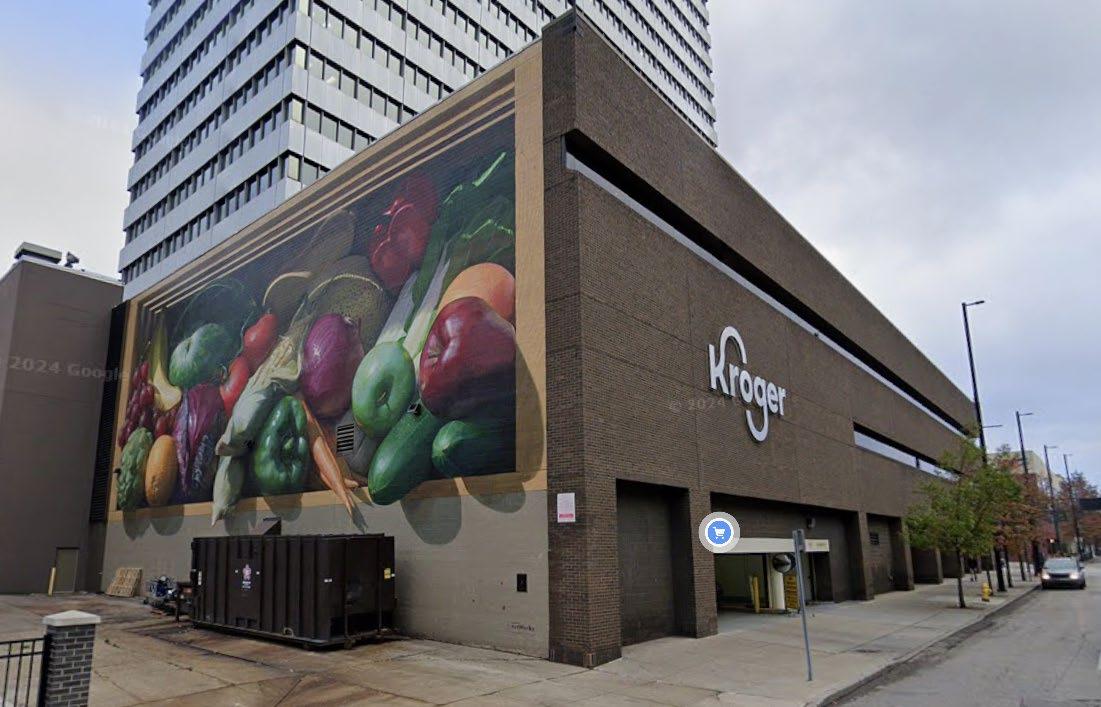
Figure 1178-01: An image of the Kroger Headquarters in Cincinnati, Ohio. A painting on the side of the structure is considered a mural-while Kroger vends fruits and vegetables, the mural does not include logos or names associated with Kroger or of any brands sold or serviced by Kroger.
(G) No mural shall be illuminated; however, a variance granted by the Zoning Board of Appeals may permit the illumination of a mural.
§1178.04 MURAL APPROVAL PROCESS
(A) Murals may be approved by submitting a zoning permit application to the Zoning Administrator, indicating that the application is for a mural.
(B) Once a mural is approved for a particular building face, a new approval is not needed for touch-ups of the paint or for a change in mural content, provided that the location and the size of the mural is not changed.
City of Garfield Heights, Ohio, Planning and Zoning Code
>Title Five | Sign Regulations
>>Chapter 1178: Mural Standards
§1179.01 PURPOSE OF RIPARIAN SETBACKS The specific purpose of these regulations is to regulate buildings, structures, uses, and related soil disturbing activities within riparian setback areas that would impair the ability of these areas to:
(A) Reduce flood impacts by absorbing peak flows, slowing the velocity of floodwaters, and regulating base flow.
(B) Assist in stabilizing the banks of designated watercourses to reduce woody debris from fallen or damaged trees, stream bank erosion, and the downstream transport of sediments eroded from such watercourse banks.
(C) Reduce pollutants in designated watercourses during periods of high flows by filtering, settling, and transforming pollutants already present in such watercourses.
(D) Reduce pollutants in designated watercourses by filtering, settling, and transforming pollutants in runoff before they enter such watercourses.
(E) Provide designated watercourse habitats with shade and food.
(F) Reduce the presence of aquatic nuisance species to maintain a diverse aquatic system.
(G) Provide riparian habitat with a wide array of wildlife by maintaining diverse and connected riparian vegetation.
(H) Minimize encroachment on designated watercourses and limiting the potential need for invasive measures that may otherwise be necessary to protect buildings, structures, and uses as well as to reduce the damage to real property and threats to public health and safety within the affected watershed.
(I) Preserve and conserve the quality and free flowing condition of designated watercourses in the interest of promoting and protecting public health and safety.
(J) These regulations have been enacted to protect and enhance the functions of riparian areas by providing reasonable controls governing buildings, structures, uses, and related soil disturbing activities within a riparian setback along designated watercourses in the City. Due to the importance of functioning riparian areas, it is the intent and purpose of these regulations that minimum riparian setbacks be given preference over minimum front, side, and rear yard setbacks, in consideration of an appeal for a variance by the Board of Zoning Appeals.
City of Garfield Heights, Ohio, Planning and Zoning Code
>Title Six | Environmental Regulations
>>Chapter 1179: Riparian Setbacks
§1179.02 APPLICABILITY
(A) These regulations shall apply to all zoning districts.
(B) The regulations set forth herein shall apply to all buildings, structures, uses, and related soil disturbing activities on a lot containing a designated watercourse, except as otherwise provided herein.
(C) The use of any building, structure or lot lawfully existing prior to the effective date of these regulations may be continued, subject to the provisions of Title Eight "Nonconformities”
(D) The repair, maintenance, restoration of a building, or uses lawfully existing prior to the effective date of these regulations may be continued or completed, subject to the provisions of Title Eight "Nonconformities”.
(E) A use and occupancy certificate or other zoning certificate shall be issued for any building, structure, use, or related soil disturbing activities on a lot containing, wholly or partly, a designated watercourse except in conformity with the regulations set forth herein.
(F) These regulations shall only apply when a riparian setback, as determined by these regulations, is proposed to be impacted.
§1179.03 DEFINITIONS. Definitions of terms related to this chapter can be found in Title Nine "Glossary of Terms” of this Planning and Zoning Code.
§1179.04 ESTABLISHMENT OF DESIGNATED WATERCOURSES AND RIPARIAN SETBACKS
(A) A designated watercourse shall include one or more of the following criteria:
(i) All watercourses draining an area equal to or greater than one-half (0.5) square mile, or
(ii) All watercourses draining an area less than one-half (0.5) square mile and having a defined bed and bank. In determining if watercourses have a defined bed and bank, the Building Commissioner may consult with representatives of the CSWCD or other technical experts.
(B) Riparian setbacks on designated watercourses shall be established as follows:
(i) A minimum of one hundred twenty (120) feet on each side of all designated watercourses draining an area equal to or greater than twenty (20) square miles.
(ii) A minimum of seventy-five (75) feet on each side of all designated watercourses draining an area equal to or greater than one-half (0.5) square mile and up to 20 square miles.
City of Garfield Heights, Ohio, Planning and Zoning Code
>Title Six | Environmental Regulations 124
>>Chapter 1179: Riparian Setbacks
(iii) A minimum of 25 feet on each side of all designated watercourses draining an area less than one-half (0.5) square mile and having a defined bed and bank as determined in these regulations.
(C) The following regulations shall apply to riparian setbacks:
(i) Riparian setbacks shall be measured in a horizontal direction outward from the ordinary high water mark of a designated watercourse.
(ii) Except as otherwise provided in this Chapter, riparian setbacks shall be preserved in their natural state.
(iii) Where the one hundred year floodplain is wider than the minimum riparian setback on either or both sides of a designated watercourse, the minimum riparian setback shall be extended to include the outermost boundary of the one hundred year floodplain as delineated on the flood hazard boundary map(s) for the affected area provided by FEMA.
(iv) Where a wetland is wider than the minimum riparian setback on either or both sides of a designated watercourse, the minimum riparian setback shall be extended to include the outermost boundary of the wetland. Wetlands shall be delineated through a site survey prepared by a qualified wetlands professional retained by the lot owner using delineation protocols accepted by the U.S. Army Corps of Engineers at the time an application is made under these regulations.
(A) The City may create a map identifying designated watercourses and their riparian setbacks. Said map is attached hereto and made a part of this regulation and is identified as Exhibit “A”. The riparian setback map may be utilized as a reference document by the Building Commissioner and the Board of Zoning Appeals in determining when the riparian setback applies.
(B) Nothing herein shall prevent the City from amending the riparian setback map from time to time as may be necessary.
(C) If any discrepancy is found between the riparian setback map and these regulations, or if any discrepancy is found between site conditions and these regulations, the criteria set forth in §1179.04 “Establishment of Designated Watercourses and Riparian Setbacks” shall prevail.
(A) The owner shall be responsible for identifying riparian setbacks as required by these regulations and shall indicate such setbacks on a site plan submitted to the Building Commissioner. Two copies of the site plan shall be submitted. In addition to the requirements set forth in this Planning and Zoning Code for a use and occupancy certificate or other zoning certificate, the owner shall provide the following information to the Building Commissioner:
City of Garfield Heights, Ohio, Planning and Zoning Code
>Title Six | Environmental Regulations 125
>>Chapter 1179: Riparian Setbacks
(B) A site plan depicting, at a minimum, the following:
(i) The boundaries of the lot with dimensions.
(ii) The location of all designated watercourses.
(iii) The limits, with dimensions, of the riparian setback.
(iv) The existing topography at intervals of two feet.
(v) The location and dimensions of any existing and proposed buildings, structures, uses, and related soil disturbing activities in relationship to all designated watercourses.
(vi) The description and location, with dimensions plus a calculation of the total area, of all land development activities, soil disturbance, and impervious cover.
(vii) If the lot included in the site plan is a part of a platted and recorded subdivision, the riparian setback, if any, shall be as shown on said plat.
(C) Such other supplementary information as may be required by the Building Commissioner or the Board of Zoning Appeals to ensure compliance with the provisions of these regulations. Such information may include, but is not limited to, the following:
(i) A site plan prepared by a professional engineer, surveyor, soils scientist, landscape architect or such other qualified professional and shall be based upon a survey of the affected lot.
(ii) The description and depiction of all erosion and sedimentation controls plus all storm water management controls, including all temporary and permanent best management practices.
(iii) North arrow, scale, date, and stamp bearing the name and registration number of the professional consultant who prepared the plan shall be provided.
(D) The Building Commissioner, may, in reviewing the site plan, consult with the CSWCD or such other expert(s) retained by the City.
(E) If land development or soil disturbing activities will occur within fifty (50) feet of the outer boundary of the applicable riparian setback as specified in these regulations, then prior to the initiation of any land development or soil disturbing activities, the riparian setback shall be clearly delineated on the affected lot by the owner with construction fencing as shown on the site plan and shall be maintained on the lot until the completion of such development or disturbance activities. No zoning certificate shall be issued until the riparian setback delineation has been completed on the lot in accordance with the approved site plan.
§1179.07 PERMITTED BUILDINGS, STRUCTURES, USES, AND RELATED SOIL DISTURBING ACTIVITIES WITHIN A RIPARIAN SETBACK WITHOUT A ZONING CERTIFICATE. Only the following buildings, structures, uses, and related soil disturbing activities may be permitted within a riparian setback without a zoning permit:
City of Garfield Heights, Ohio, Planning and Zoning Code
>Title Six | Environmental Regulations 126
>>Chapter 1179: Riparian Setbacks
(A) Recreational Activities: Fishing, hunting, picnicking, picnic tables, picnic shelters, and wildlife observation areas; trails, walkways, and paths for non-motorized vehicles constructed of pervious materials.
(B) Removal of Damaged or Diseased Trees: Damaged or diseased trees and other associated debris may be removed.
(C) Maintenance and Repairs: Maintenance and repair on buildings, structures, roads, driveways, bridges, culverts, trails, walkways, paths, wastewater treatment plans and appurtenances, storm sewers, and all other buildings, structures, and uses lawfully existing at the time of passage of this regulation, as covered by Title Eight "Nonconformities”, or permitted in the riparian setback under this regulation or through the granting of a variance.
(D) Maintenance and Cultivation of Lawns, and Landscaping: The maintenance of existing, and the cultivation of new lawns, landscaping, shrubbery, and trees.
(E) On-Site Waste Water Treatment Plants: On-site waste water treatment plans subject to the regulations enforced by the Cuyahoga County General Health District or the Ohio EPA.
(F) Revegetation and/or Reforestation: The revegetation and/or reforestation of the riparian setback so long as species of shrubs and vines recommended by CSWCD for stabilizing flood prone areas along streams within the County of Cuyahoga are utilized.
§1179.08 PERMITTED BUILDINGS, STRUCTURES, USES, AND RELATED SOIL DISTURBING ACTIVITIES WITHIN A RIPARIAN SETBACK WITH A ZONING CERTIFICATE. Only the following buildings, structures, uses, and related soil disturbing activities may be permitted within a riparian setback, subject to the approval of an application for a use and occupancy certificate by the Building Commissioner and in accordance with the following regulations and such other applicable regulations contained in this Planning and Zoning Code:
(A) Crossings: Crossings of designated watercourses through riparian setbacks with roads, driveways, easements, bridges, culverts, utility service lines, or other means may be permitted, subject to the other regulations contained in this Chapter and the regulations enforced by the CSWCD and the City Engineer. If work will occur below the ordinary high water mark of the designated watercourse, proof of compliance with the applicable conditions of a U.S. Army Corps of Engineers Section 404 Permit (either a Nationwide Permit, including the Ohio State Certification Special Conditions and Limitations, or an Individual Permit, including Ohio 401 water quality certification), shall also be provided to the Building Commissioner. Proof of compliance shall be the following:
(i) A site plan showing that any proposed crossing conforms to the general and special conditions of the applicable Nationwide Permit, or
(ii) A copy of the authorization letter from the U.S. Army Corps of Engineers approving the activities under the applicable Nationwide Permit, or
(iii) A copy of the authorization letter from the U.S. Army Corps of Engineers approving activities under an Individual Permit.
City of Garfield Heights, Ohio, Planning and Zoning Code
>Title Six | Environmental Regulations 127
>>Chapter 1179: Riparian Setbacks
(B) Streambank Stabilization Projects: Streambank stabilization projects along designated watercourses, subject to other regulations contained in this Chapter and the regulations enforced by the CSWCD. If streambank stabilization work is proposed below the ordinary high water mark of a designated watercourse, proof of compliance with the applicable conditions of U.S. Army Corps of Engineers Section 404 Permit (either a Nationwide Permit 13, including the Ohio State Certification Special Conditions and Limitations, or an Individual Permit, including Ohio 401 water quality certification), shall be provided to the Building Commissioner. Proof of compliance shall be the following:
(i) A site plan showing that any proposed crossing conforms to the general and special conditions of the Nationwide Permit 13, or
(ii) A copy of the authorization letter from the U.S. Army Corps of Engineers approving activities under Nationwide Permit 13, or
(iii) A copy of the authorization letter from the U.S. Army Corps of Engineers approving activities under an Individual Permit.
(C) Storm Water Retention and Detention Facilities: Storm water retention and detention facilities, provided:
(i) Storm water quality treatment consistent with current Ohio EPA and CSWCD regulations is incorporated into the storm water retention and detention facilities.
(ii) Where the riparian setbacks are less than or equal to 50 feet, the storm water detention and retention facilities may be located within the riparian setback.
(iii) Where the riparian setbacks are greater than 50 feet, storm water retention and detention facilities are located at least 50 feet from the ordinary high water mark of the designated watercourse.
(D) Signs: Signs in accordance with this Planning and Zoning Code.
A RIPARIAN SETBACK Any building, structure, use, or related soil disturbing activity not permitted under this regulation shall be prohibited within a riparian setback. The following buildings, structures, uses, and related soil disturbing activities are specifically prohibited:
(A) Construction: There shall be no buildings, structures, uses, or related soil disturbing activities of any kind except as permitted under these regulations.
(B) Parking Spaces or Lots and Loading/Unloading Spaces for Vehicles: There shall be no parking spaces, parking lots, loading/unloading spaces, or related soil disturbing activities.
(C) Roads and Driveways: There shall be no roads, driveways, or related soil disturbing activities except as permitted by this Chapter.
City of Garfield Heights, Ohio, Planning and Zoning Code
>Title Six | Environmental Regulations 128
>>Chapter 1179: Riparian Setbacks
§1179.10 INSPECTION OF RIPARIAN SETBACKS
(A) The City Engineer shall inspect the delineation of riparian setbacks.
(B) The owner shall notify the City Engineer and Building Commissioner at least seven days prior to the initiation of any construction, land development or soil disturbing activities on a lot.
(C) The Building Commissioner and/or City Engineer, with prior notice and the authorization of the owner, may enter the affected lot from time to time to conduct onsite inspections to ensure compliance with these regulations.
§1179.11 NONCONFORMING STRUCTURES OR USES IN THE RIPARIAN SETBACK
(A) Structures and uses within the riparian setback existing at the time of passage of this chapter that are not permitted to be located within the riparian setback under this chapter may be continued but shall not be expanded except as set forth in this section.
(B) If a structure is damaged or destroyed, the structure may be repaired or restored within 6 months from the date of the damage or destruction in order to maintain a legal non-conforming status.
§1180.01 PURPOSE OF HILLSIDE PROTECTION REGULATIONS. Whereas the hillside areas of the City differ from the City's flatlands, hillsides necessitate different provisions for their development and their protection. The Hillside Protection Regulations are established to achieve, among others, the following objectives:
(A) To permit development on hillside areas while conserving and promoting the public health, safety, convenience and general welfare by minimizing water run-off and soil erosion problems incurred in adjustment of the topography to meet development needs;
(B) To use the best accepted design, landscape architecture, architecture and civil engineering to preserve, enhance and promote the existing and future appearance and resources of hillside areas;
(C) To preserve and enhance the natural beauty of the landscape by encouraging the maximum retention of natural topographic features such as natural drainage swales, streams, slope ridge lines, rock outcroppings, vistas from and of the hillsides, trees and other natural plant formations and to retain the sense of identity and image that the hillside areas now impart to the City.
§1180.02 DEFINITIONS. Definitions of terms related to this chapter can be found in Title Nine "Glossary of Terms” of this Planning and Zoning Code.
City of Garfield Heights, Ohio, Planning and Zoning Code >Title Six | Environmental Regulations
>>Chapter 1180: Hillside Protection Regulations
§1180.03 PROCEDURES Upon the filing of a request for approval of a building permit, grade plan approval or subdivision, the Building Commissioner shall use the following procedures to determine whether the proposed action is governed by provisions of this Chapter and whether a hillside protection permit is required for a parcel or part of a parcel.
(A) The average percent slope shall be calculated and this information shall be supplied by the applicant at the time of filing of the application with the City.
(B) The application shall be reviewed by the City Engineer who shall then notify the Building Commissioner if a hillside protection permit is required.
(C) If a hillside protection permit is required, the owner/developer shall be required to include hillside control measures with grading, hydrological and landscaping plans as specified in §1180.04 “Required Hillside Control Measures, Standards and Plans” These plans shall be submitted to the City Engineer for approval.
(D) If it is determined by the Building Commissioner that the action is governed by these provisions, then a hillside protection permit shall be required before a building permit or subdivision permit is issued to the owner or developer by the City. A hillside protection permit shall be issued in phases as determined by the Building Commissioner and the City Engineer before the next phase permit will be issued.
(E) The Commission shall have the authority to request the owner to modify the hillside protection plans and preliminary plat plans in hillside areas to better meet the standards and control measures of this Chapter, to protect the health and welfare of the adjacent property owner and to protect the surrounding hillside and its natural topography.
(F) The Commission shall have the authority to modify or waive building setback requirements on a lot-by-lot basis. This authority shall be based on a greater concern for the protection of the surrounding hillside and its natural topography.
(G) The Commission shall have the authority to require the owner to place structures on the portion of the property to be developed that has a slope of less than 12% when this is feasible and possible within the confines of the area to be developed.
(H) The Commission shall approve hillside control measures, subdivision and building plans or preliminary plot plans for hillside areas if it finds based on the examination of the required studies, plans and improvements and upon the recommendations of the City Engineer that the proposed development is consistent with development policies and basic technical standards set forth in this Chapter provided, however, that the Commission may deny a permit if it is in the Commission's opinion that the proposed project is so designed or will be so located, constructed and maintained that the public health, safety and welfare will be endangered.
§1180.04 REQUIRED HILLSIDE CONTROL MEASURES, STANDARDS AND PLANS. The owner/developer shall comply with the following provisions:
(A) Pre-Construction Record. A video tape record shall be filed with the Building Commissioner prior to any building, grading or clearing activity on the parcel to be
City of Garfield Heights, Ohio, Planning and Zoning Code
>Title Six | Environmental Regulations
>>Chapter 1180: Hillside Protection Regulations
developed. This video tape record shall completely depict the pre-development condition of the parcel in sufficient detail to enable the Building Commissioner to evaluate compliance with these regulations during and following completion of construction activities under these regulations. The Building Commissioner shall have the authority to request additional video tape records of pre-development conditions of the parcel being developed to satisfy the intent of this section when in his opinion such additional records are required.
(B) Grading Plans. A grading plan shall be required for each lot in conformance with Section 1115.03 of the Subdivision Regulations and in addition shall show the natural topography of the total parcel to be developed, the location and size of all structures, the finish grade of all improvement locations and the dimensions, elevations and contours of any proposed earth moving and shall be submitted with each application for a hillside protection permit and shall show the following:
(i) A Detailed Topographic Map. A contour map with two-foot integrals or suitable cross sections or profiles of areas where streets, driveways, buildings, utilities or grading construction is proposed shall be required.
(ii) Road Profiles. Profiles and cross sections of all significant changes in the cross slopes; the cross section to show proposed and natural grade at the centerline of the road, the right-of-way line and the proposed building setback lines shall be required.
(iii) Special Terrain Notes. Notes and details of existing terrain shall be shown over the required topographic information.
(iv) Material Disposal. A description shall be included of methods to be employed in disposing of soil and other material removed, including the location of the disposal site.
(v) Timetable. A schedule shall be included showing when each stage of the project will be completed, including the estimated starting and completion dates.
(C) Earth Moving Controls. The following minimum standards shall apply to earth moving:
(i) Minimum Alterations. Earth moving shall be limited to the minimum required for building foundations, driveways, drainage control structures and immediate yard areas. With the exception of purely stockpiling or restoration efforts, substantial earth moving shall not be permitted.
(ii) Erosion Control. All earth moving shall create the lowest possible potential for airborne or waterborne transportation of soil.
(iii) Compaction. All fill shall be stabilized in conformance with generally accepted engineering standards, including a compacted density of a least 95%.
(iv) Prompt Completion. All earth moving shall be accomplished in the shortest practical period of time. In no event shall the existing natural vegetation be destroyed, removed or disturbed more than fifteen days prior to the initiation of construction.
(v) Cut and Fill. Cut and fill slopes shall be no steeper than two horizontal to one vertical; fill slopes shall not be located on natural slopes steeper than 2:1; or
City of Garfield Heights, Ohio, Planning and Zoning Code
>Title Six | Environmental Regulations
>>Chapter 1180: Hillside Protection Regulations
where fill slope toes out within 12 feet horizontal of the top of an existing or planned cut slope.
(vi) No unnecessary cuts and/or fills shall be allowed in order to create additional lots or building sites.
(D) Hydrological Controls. The following standards shall apply to hydrological controls:
(i) Natural Channels. Natural drainageways shall be preserved to the maximum extent possible.
(ii) Controlled Run-Off. Run-off from concentrated impervious surfaces shall be collected and transported in a pipe or other approved manner to a City storm sewer system if available, or if unavailable, to the bottom of a ravine in a safe, adequate and nonerosive manner. Where required by the City Engineer, or the CSWD, storm water retention facilities shall be installed.
(iii) Interceptor Ditches. Where required, interceptor ditches shall be established above steep slopes in such a way as not to saturate or erode soil, and the intercepted water shall be conveyed in a pipe or other approved manner to a City storm sewer system or to the bottom of a ravine or steep slope.
(iv) Discharge Point Stabilization. Natural drainageways shall be established by means consistent with sound professional engineering practice, below drainage and culvert discharge points for a distance sufficient to convey the discharge without channel erosion and in such manner as to dissipate the energy of the discharge.
(v) Early Completion. The overall drainage system shall be completed and made operational at the earliest possible time during construction.
(vi) Impact on Adjacent Property. Natural or usual flow of surface or subsurface water shall not be altered or obstructed in any way by grade changes that may adversely affect the property of another by either contributing to pooling or collection of waters, or to the concentration or intensification of surface water discharge. However, construction which might otherwise be prohibited hereinabove may be allowed if such waters are safely and adequately drained in a nonerosive manner by a pipe or other approved manner to a storm sewer or to a channel at the bottom of a ravine or steep slope.
(E) Hydrological Control Plan. A hydrological control plan, prepared by a registered professional civil engineer or landscape architect, shall be submitted with each application for a hillside protection permit. This plan shall include the following:
(i) Hydrologic Inventory. A reasonably detailed description of:
(1) The direction of flow within the local drainage basin;
(2) All natural drainage channels directed toward and away from the site within 50 feet of the perimeter of the site;
(3) Other natural drainageways which may affect or be affected by the proposal; and
(4) Any future realignment of the natural ravine channel.
City of Garfield Heights, Ohio, Planning and Zoning Code
>Title Six | Environmental Regulations
>>Chapter 1180: Hillside Protection Regulations
(ii) Special Notations. Special notations shall be included highlighting details of the terrain, existing natural surface drainage and areas subject to seepage or spring flow.
(iii) Proposed Facilities. The location of all surface and subsurface drainage devices and protective measures to be installed as part of the proposed development, together with a statement concerning any active erosion occurring at the outlet of existing or proposed systems.
(F) Vegetation and Revegetation. The following standards shall apply to vegetation and revegetation:
(i) Schedule. The percent of each parcel to remain in an undisturbed state shall be determined by the average percent of slope within each parcel to be developed. The following schedule shall apply to development in hillside areas:
(ii) Smallest Area. The smallest practical area of land shall be exposed in any given time during development. Such exposure shall be kept to as short a duration of time as practical.
(iii) Temporary Measures. Where required, temporary vegetation, mulch or other acceptable cover shall be used to protect areas exposed during development and to prevent airborne or waterborne transportation of soil.
(iv) Revegetation. A mix of plantings (preferably native with adequate deep root systems) shall be used to landscape steep slope areas disturbed by earth moving and construction.
(G) Landscape Plan. A landscape plan, prepared or approved in writing by a professional registered landscape architect trained and experienced in both the characteristics of plant material and proper procedures for installation, shall be submitted with each application for a hillside protection permit. This plan shall include the following:
(i) Existing Inventory. A site plan inventory describing the existing vegetation cover of the property and showing those areas where the vegetation will be removed as part of the proposed development.
(ii) Revegetation. A site plan describing proposed revegetation of disturbed areas and specifying the materials to be used.
(iii) Written Description. A detailed description of any slope stabilization and revegetation methods, together with the rationale for selecting the plant materials and planting techniques to be used.
of Garfield Heights, Ohio, Planning and Zoning Code >Title Six | Environmental Regulations
(H) Excluded Activities
(i) Landscaping. This chapter shall not be interpreted to prohibit normal landscape maintenance or routine arboreal activities or to prohibit small scale planting of ornamental flowers or shrubs, or the removal of diseased, dead or damaged trees. However, such activities shall be carried out to conformance with the standards of vegetation or revegetation of this Chapter.
§1180.05 COMPLIANCE PROVISIONS. The following provisions pertain to any construction or any earth moving activities permitted by the administration of this Chapter:
(A) Limited Obligation. Compliance with the procedures of this Chapter and the issuance of any related permits shall not be construed to impose any legal obligation upon the City or its elected or appointed officials.
(B) Civil Claims. Compliance with the procedures of this Chapter and the issuance of related permits shall not relieve the owner, developer or builder from civil liability claims by other property owners.
(C) Endorsement. Compliance with the procedures of this Chapter and the issuance of related permits do not imply approval of, the need for or the benefit or efficacy of the proposed construction; nor does it constitute any assertion that the proposed construction will not result in damage to the property in question or to adjoining property.
§1180.06 ADMINISTRATION AND ENFORCEMENT
(A) Additional Site Inspections. Additional site inspections shall be scheduled by the Building Commissioner or City Engineer during and upon completion of each phase of the hillside development. Construction activity shall be halted if it is found upon inspection that a situation exists or could result which endangers the health, safety or welfare of adjacent property owners.
(B) Relation To Other Laws. The provision of these Regulations shall supplement any and all laws of the State, ordinances of the City or any and all rules and regulations promulgated by authority of such law or ordinance relating to the purpose and scope of these Regulations. Whenever the requirements of any other lawfully adopted law, ordinance, regulation, resolution or rule, may also apply, the more restrictive or that imposing the higher standards shall govern.
§1181.01 PURPOSE AND APPLICABILITY OF STORMWATER MANAGEMENT REGULATIONS
(A) The purpose of this regulation is to establish technically feasible and economically reasonable stormwater management standards to achieve a level of stormwater quality and quantity control that will minimize damage to property and degradation of water resources and will promote and maintain the health, safety, and welfare of the citizens of the City of Garfield Heights:
City of Garfield Heights, Ohio, Planning and Zoning Code >Title Six | Environmental Regulations
>>Chapter 1181: Stormwater Management Regulations
(B) This regulation requires owners who develop or redevelop their property within the City of Garfield Heights to:
(i) Control stormwater runoff from their property and ensure that all Stormwater Control Measures (SCMs) are properly designed, constructed, and maintained.
(ii) Reduce water quality impacts to receiving water resources that may be caused by new development or redevelopment activities.
(iii) Control the volume, rate, and quality of stormwater runoff originating from their property so that surface water and groundwater are protected, and flooding and erosion potential are not increased.
(iv) Minimize the need to construct, repair, and replace subsurface storm drain systems.
(v) Preserve natural infiltration and ground water recharge, and maintain subsurface flow that replenishes water resources, except in slippage prone soils.
(vi) Incorporate stormwater quality and quantity controls into site planning and design at the earliest possible stage in the development process.
(vii) Reduce the expense of remedial projects needed to address problems caused by inadequate stormwater management.
(viii) Maximize use of current Best Management Practices (BMPs) or Stormwater Control Practices (SCMs) that serve multiple purposes including, but not limited to, flood control, erosion control, fire protection, water quality protection, recreation, and habitat preservation.
(ix) Design sites to minimize the number of stream crossings and the width of associated disturbance in order to minimize future expenses related to the maintenance and repair of stream crossings.
(x) Maintain, promote, and re-establish conditions necessary for naturally occurring stream processes that assimilate pollutants, attenuate flood flows, and provide a healthy water resource.
(C) This regulation shall apply to all parcels used or being developed, either wholly or partially, for new or relocated projects involving highways and roads; subdivisions or larger common plans of development; industrial, commercial, institutional, or residential projects; building activities on farms; redevelopment activities; grading; and all other uses that are not specifically exempted in this Section
(D) Public entities, including the State of Ohio, Cuyahoga County, and the City of Garfield Heights shall comply with this regulation for roadway projects initiated after March 10, 2006 and, to the maximum extent practicable, for projects initiated before that time.
(E) This regulation does not apply to activities regulated by, and in compliance with, the Ohio Agricultural Sediment Pollution Abatement Rules.
(F) This regulation does not require a Comprehensive Stormwater Management Plan for linear construction projects, such as pipeline or utility line installation, that do not
City of Garfield Heights, Ohio, Planning and Zoning Code >Title Six | Environmental Regulations
>>Chapter 1181: Stormwater Management Regulations
result in the installation of impervious surface as determined by the City Engineer Such projects must be designed to minimize the number of stream crossings and the width of disturbance. Linear construction projects must comply with the requirements of Chapter 1182 “Erosion and Sediment Control Requirements”
§1181.02 DEFINITIONS. Definitions of terms related to this chapter can be found in Title Nine "Glossary of Terms” of this Planning and Zoning Code.
§1181.03
(A) Compliance with the provisions of this regulation shall not relieve any person from responsibility for damage to any person otherwise imposed by law. The provisions of this regulation are promulgated to promote the health, safety, and welfare of the public and are not designed for the benefit of any individual or any particular parcel of property.
(B) By approving a Comprehensive Stormwater Management Plan under this regulation, the City of Garfield Heights does not accept responsibility for the design, installation, and operation and maintenance of SCMs.
§1181.04
(A) Where this regulation is in conflict with other provisions of law or ordinance or requirements in the Construction General Permit, the most restrictive provisions, as determined by the Building Commissioner, shall prevail.
(B) If any clause, section, or provision of this regulation is declared invalid or unconstitutional by a court of competent jurisdiction, the validity of the remainder shall not be affected thereby.
(C) This regulation shall not be construed as authorizing any person to maintain a nuisance on their property, and compliance with the provisions of this regulation shall not be a defense in any action to abate such a nuisance.
(D) Failure of the City to observe or recognize hazardous or unsightly conditions or to recommend corrective measures shall not relieve the site owner from the responsibility for the condition or damage resulting therefrom, and shall not result in the City of Garfield Heights, its officers, employees, or agents being responsible for any condition or damage resulting therefrom.
§1181.05
(A) This regulation requires that a Comprehensive Stormwater Management Plan be developed and implemented for all soil disturbing activities disturbing one (1) or more acres of total land, or less than one (1) acre if part of a larger common plan of development or sale disturbing one (1) or more acres of total land, and on which any regulated activity of Section 1170.01(c) is proposed. A Comprehensive Stormwater Management Plan must be developed and implemented for all commercial and industrial site development disturbing more than two-tenths (0.2) of an acre. The
City of Garfield Heights, Ohio, Planning and Zoning Code
>Title Six | Environmental Regulations 136
>>Chapter 1181: Stormwater Management Regulations
Building Commissioner and/or City Engineer may require a Comprehensive Stormwater Management Plan for any soil disturbing activity.
(B) The City of Garfield Heights shall administer this regulation, shall be responsible for determination of compliance with this regulation, and shall issue notices and orders as may be necessary. The City of Garfield Heights may consult with the Cuyahoga County SWCD, state agencies, private engineers, stormwater districts, or other technical experts in reviewing the Comprehensive Stormwater Management Plan.
(A) Pre-Application Meeting. The applicant shall attend a Pre-Application Meeting with the City Engineer and/or the Building Commissioner to discuss the proposed project, review the requirements of this regulation, identify unique aspects of the project that must be addressed during the review process, and establish a preliminary review and approval schedule.
(B) Preliminary Comprehensive Stormwater Management Plan. The applicant shall submit two sets of a Preliminary Comprehensive Stormwater Management and the applicable fees to the Building Commissioner. The Preliminary Plan shall show the proposed property boundaries, setbacks, dedicated open space, public roads, water resources, SCMs, and easements in sufficient detail and engineering analysis to allow the City of Garfield Heights to determine if the site is laid out in a manner that meets the intent of this regulation and if the proposed SCMs are capable of controlling runoff from the site in compliance with this regulation. The applicant shall submit two sets of the Preliminary Plan and applicable fees as follows:
(i) For subdivisions: In conjunction with the submission of the preliminary subdivision plan.
(ii) For other construction projects where the development or redevelopment plan will result in the installation of impervious areas, artificial turf or permeable pavement systems: In conjunction with the application for a Zoning Permit.
(iii) For general clearing projects: In conjunction with the application for a zoning permit.
(C) Final Comprehensive Stormwater Management Plan. The applicant shall submit two sets of a Final Comprehensive Stormwater Management Plan and the applicable fees to the City of Garfield Heights Building Commissioner in conjunction with the submittal of the final plat, improvement plans, or application for a building or zoning permit for the site. Final Comprehensive Stormwater Management Plans shall meet the requirements of §1181.09 “Comprehensive Stormwater Management Plans” and shall be approved by the City Engineer prior to approval of the final plat and/or before issuance of a zoning permit.
(D) Review and Comment. The City Engineer shall review the Preliminary and Final Plans submitted and shall approve or return for revisions with comments and recommendations for revisions. A Preliminary or Final Plan rejected because of deficiencies shall receive a narrative report stating specific problems and the procedures for filing a revised Preliminary or Final Plan.
City of Garfield Heights, Ohio, Planning and Zoning Code
>Title Six | Environmental Regulations 137
>>Chapter 1181: Stormwater Management Regulations
(E) Approval Necessary. The Building Commissioner shall not issue a zoning permit without an approved Comprehensive Stormwater Management Plan.
(F) Valid for Two Years. Approvals issued in accordance with this regulation shall remain valid for two years from the date of approval or as stipulated in the Construction General Permit. The Building Commissioner shall reserve the right to extend the approvals if the site has been actively maintained and managed, in accordance with the City ordinances and policies.
§1181.07 COMPLIANCE WITH STATE AND FEDERAL REGULATIONS. Approvals issued in accordance with this regulation do not relieve the applicant of responsibility for obtaining all other necessary permits and/or approvals from other federal, state, and/or county agencies. If requirements vary, the most restrictive shall prevail. These permits may include, but are not limited to, those listed below. Applicants are required to show proof of compliance with these regulations before the City of Garfield Heights will issue a building or zoning permit.
(A) Ohio Environmental Protection Agency (Ohio EPA) National Pollutant Discharge Elimination System (NPDES) Permits authorizing stormwater discharges associated with construction activity or the most current version thereof: Proof of compliance with these requirements shall be the applicant’s Notice of Intent (NOI), a copy of the Ohio EPA Director’s Authorization Letter with NPDES Facility Permit number for the NPDES Permit, or a letter from the site owner certifying and explaining why the NPDES Permit is not applicable.
(B) Section 401 of the Clean Water Act: Proof of compliance shall be a copy of the Ohio EPA Water Quality Certification application tracking number, public notice, project approval, or a letter from the site owner certifying that a qualified professional has surveyed the site and determined that Section 401 of the Clean Water Act is not applicable. Wetlands, and other waters of the United States, shall be delineated by protocols accepted by the U.S. Army Corps of Engineers at the time of application of this regulation.
(C) Ohio EPA Isolated Wetland or Ephemeral Stream Permit: Proof of compliance shall be a copy of Ohio EPA’s Isolated Wetland Permit or Ephemeral Stream Permit application tracking number, public notice, project approval, or a letter from the site owner certifying that a qualified professional has surveyed the site and determined that Ohio EPA’s Isolated Wetlands Permit or Ephemeral Stream Permit is not applicable. Isolated wetlands shall be delineated by protocols accepted by the U.S. Army Corps of Engineers at the time of application of this regulation.
(D) Section 404 of the Clean Water Act: Proof of compliance shall be a copy of the U.S. Army Corps of Engineers Individual Permit application, public notice, or project approval, if an Individual Permit is required for the development project. If an Individual Permit is not required, the site owner shall submit proof of compliance with the U.S. Army Corps of Engineer’s Nationwide Permit Program. This shall include one of the following:
(i) A letter from the site owner certifying that a qualified professional has surveyed the site and determined that Section 404 of the Clean Water Act is not applicable.
City of Garfield Heights, Ohio, Planning and Zoning Code
>Title Six | Environmental Regulations 138
>>Chapter 1181: Stormwater Management Regulations
(ii) A site plan showing that any proposed fill of waters of the United States conforms to the general and special conditions specified in the applicable Nationwide Permit. Wetlands, and other waters of the United States, shall be delineated by protocols accepted by the U.S. Army Corps of Engineers at the time of application of this regulation.
§1181.08 OHIO DAM SAFETY LAW. Proof of compliance shall be a copy of the ODNR Division of Water Resources permit application tracking number, a copy of the project approval letter from the ODNR Division of Water Resources, or a letter from the site owner certifying and explaining why the Ohio Dam Safety Law is not applicable.
§1181.09 COMPREHENSIVE STORMWATER MANAGEMENT PLANS. Comprehensive Stormwater Management Plan Required: The applicant shall develop a Comprehensive Stormwater Management Plan describing how the quantity and quality of stormwater will be managed after construction is completed for every discharge from the site and/or into a water resource or small Municipal Separate Storm Sewer System (MS4). Comprehensive Stormwater Management Plans must meet the requirements in the Construction General Permit and these regulations.
(A) Preparation by Professional Engineer. The Comprehensive Stormwater Management Plan shall be prepared by a registered Professional Engineer and include supporting calculations, plan sheets, and design details. To the extent necessary, as determined by the City Engineer, a site survey shall be performed by a registered Professional Surveyor to establish boundary lines, measurements, or land surfaces.
(B) Community Procedures. The City Engineer shall prepare and maintain procedures providing specific criteria and guidance to be followed when designing the stormwater management system for the site. These procedures may be updated from time to time, at the discretion of the City Engineer based on improvements in engineering, science, monitoring, and local maintenance experience. The City Engineer shall make the final determination of whether SCMs proposed in the Comprehensive Stormwater Management Plan meet the requirements of this regulation to be used in the City of Garfield Heights.
(C) Contents of Comprehensive Stormwater Management Plan. The Comprehensive Stormwater Management Plan must contain all elements and meet all requirements specified in the Construction General Permit. It shall also meet the following requirements.
(i) Location information. The application shall note the phase, if applicable, of the overall development plan and list sublot numbers if project is a subdivision. The Site description shall include, at a minimum the following:
(1) A description of the nature and type of the construction activity (e.g. residential, L.I.D. Development, shopping mall, road project, etc.)
(2) The total area of the site and the area of the site anticipated to be disturbed during each phase of development including grubbing, clearing, excavation, filling, and grading, including off-site fill or borrow areas even if not within the City of Garfield Heights.
(3) Description of prior land use.
City of Garfield Heights, Ohio, Planning and Zoning Code
>Title Six | Environmental Regulations 139
>>Chapter 1181: Stormwater Management Regulations
(4) The estimate of the impervious area and percentage of imperviousness created by the soil-disturbing activity both pre- and post-development.
(5) Soil boring logs and locations, including soil series and association, hydrologic soils group, soil porosity, infiltration characteristics, depth to groundwater, depth to bedrock, and any identified impervious layers.
(6) If available, the quality of any known pollutant discharge from the site such as that which may result from previous contamination caused by prior uses.
(7) The location and name of the immediate water resource(s) and the first subsequent water resource(s).
(8) The aerial plan view extent and description or water resources at or near the site that will be disturbed or will receive discharges from the project.
(9) Describe the current condition of water resources including the vertical stability of stream channels and indications of channel incision that may be responsible for current or future sources of high sediment loading or loss of channel stability.
(ii) Site Maps and SCM Design Plans. It is preferred that all SCMs and the entire site be shown on one plan sheet to allow a complete view of the site during plan review. If a smaller scale is used to accomplish this, separate sheets providing an enlarged view of areas on individual sheets should also be provided. Existing and proposed drainage patterns and any relevant offsite SCMs should be depicted. For each SCM, include the following:
(1) An individual identification number
(2) Location and size
(3) Final site conditions and detail drawings of stormwater inlets and permanent SCMs. Details of SCMs shall be drawn to scale and shall show relevant volumes, elevations and sizes of contributing drainage areas.
(4) A completed Ohio EPA WQv Calculator Spreadsheet and/or Runoff Reduction Spreadsheet or other equivalent compliance tools provided by Ohio EPA.
(5) Any supplemental information requested by the City Engineer and Building Commissioner.
(iii) Required Calculations. The applicant shall submit calculations for projected stormwater runoff flows, volumes, and timing into and through all SCMs for flood control, channel protection, water quality, and the condition of the habitat, stability, and incision of each water resource and its floodplain. These submittals shall be completed for both pre- and post-development land use conditions and shall include the underlying assumptions and hydrologic and hydraulic methods and parameters used for these calculations. The applicant shall also include critical storm determination and demonstrate that the runoff from offsite areas have been considered in the calculations. For each SCM,
City of Garfield Heights, Ohio, Planning and Zoning Code
>Title Six | Environmental Regulations
identify the drainage area and size in acres, percent impervious cover within the drainage area, volumetric runoff coefficient, peak discharge, and the time of concentration for each subwatersheds. Pervious and impervious areas should be treated as separate subwatersheds unless allowed at the discretion of the community engineer. Identify the SCM surface area, discharge and dewatering time, outlet type and dimensions.
(iv) Inspection and Maintenance Agreement. The Inspection and Maintenance Agreement required for SCMs under this regulation is a stand-alone document between the City of Garfield Heights and the applicant. This agreement shall be recorded with the County Recorder. The agreement, at a minimum, shall include:
(1) The location of each SCM on the site;
(1) The schedule for regular maintenance and responsible party for such, including the source of funding for such;
(2) Agreed upon submission dates for maintenance reporting to the City of Garfield Heights;
(3) Agreement to permit the City of Garfield Heights to enter the property to perform any corrective actions identified in the inspection report if the landowner(s), organizations, or municipality responsible for maintenance do not make the required corrections in a specified time period. The City of Garfield Heights shall be reimbursed by the land owner(s), organization responsible for maintenance for any and all expenses incurred within ten (10) days of receipt of invoice from the City of Garfield Heights.
(4) A release of the City of Garfield Heights from all damages, accidents, casualties, occurrences, or claims that might arise or be asserted against the City of Garfield Heights from the construction, presence, existence, or maintenance of the storm water management practices proposed by the owner(s).
(1) This plan will meet the requirements of the Construction General Permit and will be developed by the applicant and reviewed by the City Engineer. Maintenance requirements of each SCM during and after construction should be included. Once the Inspection and Maintenance Plan is approved, a recorded copy of the Plan must be provided to the property owner or association that will be responsible for long-term operation and maintenance of the BMP and submitted to the City Engineer as part of the final inspection approval as described in §1181.13 “Maintenance and Final Inspection Approval ”
(2) Alteration or termination of these stipulations is prohibited. The applicant must provide a draft of the Inspection and Maintenance Agreement as part of the Comprehensive Storm Water Management Plan submittal. Once a draft is approved, a recorded copy of the Agreement must be submitted to the City of Garfield Heights to receive final inspection approval of the site.
City of Garfield Heights, Ohio, Planning and Zoning Code
>Title Six | Environmental Regulations
>>Chapter 1181: Stormwater Management Regulations
(vi) Failure to provide the City of Garfield Heights with a recorded copy of the approved Inspection and Maintenance Agreement shall restrict the Zoning Administrator from approving Zoning Permits within the applicable project area. The City of Garfield Heights reserves the right to revoke bonding on the project until a final approved agreement is provided.
(A) General. The stormwater system, including SCMs for storage, treatment and control, and conveyance facilities, shall be designed to prevent structure flooding during the 100-year, twenty-four (24) hour storm event; to maintain predevelopment runoff patterns, flows, and volumes; to meet the requirements of the Construction General Permit; and to meet the following criteria:
(i) Integrated SCMs that Address Degradation of Water Resources. The SCMs shall function as an integrated system that controls flooding and minimizes the degradation of the water resources receiving stormwater discharges from the site. Acceptable SCMs shall:
(1) Not disturb riparian areas unless the disturbance is intended to support a watercourse restoration project and complies with Chapter 1179 “Riparian Setbacks”.
(2) Maintain predevelopment hydrology and groundwater recharge on as much of the site as practicable. Where feasible, bioretention, permeable pavement with infiltration, underground storage with infiltration, infiltration trenches, infiltration basins, and/or rainwater harvesting must be the water quality SCMs used. Separate SCMs may be used for peak discharge control and water quality treatment.
(3) Only install new impervious surfaces and compact soils where necessary to support future land use.
(4) Compensate for increased runoff volumes caused by new impervious surfaces and soil compaction by reducing stormwater peak flows to less than predevelopment levels.
(5) Be designed according to the methodology included in the most current edition of Rainwater and Land Development Manual or another design manual acceptable for use by the City of Garfield Heights and Ohio EPA.
(ii) Practices Designed for Final Use. SCMs shall be designed to achieve the stormwater management objectives of this regulation, to be compatible with the proposed post-construction use of the site, to protect the public health, safety, and welfare, and to function safely with routine maintenance.
(iii) Stormwater Management for All Lots. Areas developed for a subdivision, as defined in Chapter Section 1100 of the Planning and Zoning Code shall provide stormwater management and water quality controls for the development of all subdivided lots. This shall include provisions for lot grading and drainage that prevent structure flooding during the 100-year, 24-hour storm; and maintain,
of Garfield Heights, Ohio, Planning and Zoning Code >Title Six | Environmental Regulations
>>Chapter 1181: Stormwater Management Regulations
to the extent practicable, the pre-development runoff patterns, volumes, and peaks from each lot.
(iv) Stormwater Facilities in Water Resources. SCMs and related activities shall not be constructed in water resources unless the applicant shows proof of compliance with all appropriate permits from the Ohio EPA, the U.S. Army Corps, and other applicable federal, state, and local agencies as required in §1181.07 “Compliance with State and Federal Regulations” of this regulation, and the activity is in compliance with Chapter 1182 “Erosion and Sediment Control Requirements” and Chapter 1179 “Riparian Setbacks,” all as determined by the City Engineer.
(v) Stormwater Ponds and Surface Conveyance Channels. All stormwater pond and surface conveyance designs must provide a minimum of two-foot freeboard above the projected peak stage within the facility during the 100-year, 24-hour storm. When designing stormwater ponds and conveyance channels, the applicant shall consider public safety as a design factor and alternative designs must be implemented where site limitations would preclude a safe design.
(vi) Exemption. The site where soil-disturbing activities are conducted shall be exempt from the requirements of §1181.07 “Compliance with State and Federal Regulations” if it can be shown to the satisfaction of the City Engineer that the site is part of a larger common plan of development where the stormwater management requirements for the site are provided by an existing SCM, or if the stormwater management requirements for the site are provided by SCMs defined in a regional or local stormwater management plan approved by the City Engineer.
(vii) Maintenance: All SCMs shall be maintained in accordance with the Inspection and Maintenance Plan and Agreements approved by the City Engineer.
(viii) Ownership. Unless otherwise required by the City of Garfield Heights, SCMs serving multiple lots in subdivisions shall be on a separate lot held and maintained by an entity of common ownership or, if compensated by the property owners, by the City of Garfield Heights as a dedicated public space. SCMs serving single lots shall be placed on these lots, protected within an easement, and maintained by the property owner.
(ix) Preservation of Existing Natural Drainage. Practices that preserve the existing natural drainage shall be used to the maximum extent practicable. Such practices may include minimizing site grading and compaction; protecting and/or restoring water resources, riparian areas, and existing vegetation and vegetative buffer strips; phasing of construction operations in order to minimize the amount of disturbed land at any one time, and designation of tree preservation areas or other protective clearing and grubbing practices; and maintaining unconcentrated stormwater runoff to and through these areas.
(x) Post-Construction Soil Restoration. Except for areas that will be covered by impervious surface or have been incorporated into an SCM, the soil moistureholding capacity of areas that have been cleared and graded must be restored to that of the original, undisturbed soil to the maximum extent practicable. Areas that have been compacted or had the topsoil or duff layer removed
City of Garfield Heights, Ohio, Planning and Zoning Code
>Title Six | Environmental Regulations
>>Chapter 1181: Stormwater Management Regulations
should be amended using the soil profile restoration design criteria in the Rainwater and Land Development Manual.
(B) Stormwater Conveyance Design Criteria. All SCMs shall be designed to convey stormwater to allow for the maximum removal of pollutants and reduction in flow velocities.
(C) This shall include but not be limited to:
(i) Surface Water Protection. The City Engineer may allow modification to streams, rivers, lakes, wetlands or other surface waters only if the applicant shows proof of compliance with all appropriate permits from the Ohio EPA, the U.S. Army Corps, and other applicable federal, state, and local agencies as required in §1181.07 “Compliance with State and Federal Regulations” of this regulation, and the activity is in compliance with Chapter 1182 “Erosion and Sediment Control Requirements” and Chapter 1183 “Illicit Discharge and Illegal Connection Control,” all as determined by the City Engineer.
(ii) At a minimum, stream relocation designs must show how the project will minimize changes to the vertical stability, floodplain form, channel form, and habitat of upstream and downstream channels on and off the property. Design modification to existing streams, rivers, lakes and wetlands within FEMA designated floodways will require the Owner to apply for the appropriate mapping modifications per FEMA regulations. The cost for such a plan modification shall be born by the land owner.
(iii) Off-Site Stormwater Discharges. Off-site stormwater runoff that discharges to or across the applicant’s development site shall be conveyed through the stormwater conveyance system planned for the development site at its existing peak flow rates during each design storm. Off-site flows shall be diverted around stormwater quality control facilities, or the stormwater quality control facility shall be sized to treat the off-site flow. Comprehensive Stormwater Management Plans will not be approved until it is demonstrated to the satisfaction of the City Engineer that off-site runoff will be adequately conveyed through the development site in a manner that does not exacerbate upstream or downstream flooding and erosion.
(iv) Sheet Flow. The site shall be graded in a manner that maintains sheet flow over as large an area as possible. The maximum area of sheet flow shall be determined based on the slope, the uniformity of site grading, and the use of easements or other legally-binding mechanisms that prohibit regrading and/or the placement of structures within sheet flow areas. The sheet flow length shall not exceed 75 feet from impervious area or 150 feet from pervious areas. Flow shall be directed into an open channel, storm sewer, or other SCMs from areas too long and/or too large to maintain sheet flow, all as determined by the City Engineer.
(v) Open Channels. Unless otherwise allowed by the City Engineer, drainage tributary to SCMs shall be provided by an open channel with vegetated banks and designed to carry the ten-year, 24-hour stormwater runoff from upstream contributory areas.
City of Garfield Heights, Ohio, Planning and Zoning Code
>Title Six | Environmental Regulations
>>Chapter 1181: Stormwater Management Regulations
(vi) Open Drainage Systems. Open drainage systems shall be preferred on all new development sites to convey stormwater where feasible. Storm sewer systems shall be allowed only when the site cannot be developed at densities allowed under City of Garfield Heights zoning or where the use of an open drainage system affects public health or safety, all as determined by the City Engineer. The following criteria shall be used to design storm sewer systems when necessary: NOTE: The following sections are typical stormwater conveyance design criteria. Either use these criteria or include the pertinent sections of your existing stormwater conveyance design criteria.
(1) Storm sewers shall be designed such that they do not surcharge from runoff caused by the five-year, 24-hour storm, and that the hydraulic grade line of the storm sewer stays below the gutter flow line of the overlying roadway, or below the top of drainage structures outside the roadway during a ten-year, 24-hour storm. The system shall be designed to meet these requirements when conveying the flows from the contributing drainage area within the proposed development and existing flows from offsite areas that are upstream from the development.
(2) The minimum inside diameter of pipe to be used in public storm sewer systems is 12 inches. Smaller pipe sizes may be used in private systems, subject to the approval of the City Engineer.
(3) All storm sewer systems shall be designed taking into consideration the tailwater of the receiving facility or water resource. The tailwater elevation used shall be based on the design storm frequency. The hydraulic grade line for the storm sewer system shall be computed with consideration for the energy losses associated with entrance into and exit from the system, friction through the system, and turbulence in the individual manholes, catch basins, and junctions within the system.
(4) The inverts of all curb inlets, manholes, yard inlets, and other structures shall be formed and channelized to minimize the incidence of quiescent standing water where mosquitoes may breed.
(5) Headwalls shall be required at all storm sewer inlets or outlets to and from open channels or lakes. Designs where the open flow channel is steeper than or equal to one percent shall include a stone rip-wrap or other approved erosion control measure as approved by the City Engineer.
(vii) Water Resource Crossings. The following criteria shall be used to design structures that cross a water resource in the City of Garfield Heights:
(1) Water resource crossings other than bridges shall be designed to convey the stream's flow for the minimum 25-year, 24-hour storm.
City of Garfield Heights, Ohio, Planning and Zoning Code >Title Six | Environmental Regulations
>>Chapter 1181: Stormwater Management Regulations
(2) Bridges, open bottom arch or spans are the preferred crossing technique and shall be considered in the planning phase of the development. Bridges and open spans should be considered for all State Scenic Rivers, coldwater habitat, exceptional warmwater habitat, seasonal salmonid habitat streams, and Class III headwater streams. The footers or piers for these bridges and open spans shall not be constructed below the ordinary high-water mark.
(3) If a culvert or other closed bottom crossing is used, 25% of the cross sectional area or a minimum of one foot of box culverts and pipe arches must be embedded below the channel bed. The conduit or conveyance must be sized to carry the 25-year storm under these conditions.
(4) The minimum inside diameter of pipes to be used for crossings shall be 12 inches.
(5) The maximum slope allowable shall be a slope that produces a 10-fps velocity within the culvert barrel under design flow conditions. Erosion protection and/or energy dissipaters shall be required to properly control entrance and outlet velocities.
(6) All culvert installations shall be designed with consideration for the tailwater of the receiving facility or water resource. The tailwater elevation used shall be based on the design storm frequency.
(7) Headwalls shall be required at all culvert inlets or outlets to and from open channels or lakes.
(8) Streams with a drainage area of five square miles or larger shall incorporate floodplain culverts at the bankfull elevation to restrict head loss differences across the crossing so as to cause no rise in the 100-year storm event.
(9) Bridges shall be designed such that the hydraulic profile through a bridge shall be a minimum of one foot below the bottom chord of the bridge for either the 100-year, 24-hour storm, or the 100-year flood elevation as determined by FEMA, whichever is more restrictive.
(viii) Overland Flooding. Overland flood routing paths shall be used to convey stormwater runoff from the 100-year, 24-hour storm event to an adequate receiving water resource or SCM such that the runoff is contained within the drainage easement for the flood routing path and does not cause flooding of buildings or related structures. The peak 100-year water surface elevation along flood routing paths shall be at least two feet below the finished grade elevation of all structures. When designing the flood routing paths, the conveyance capacity of the site's storm sewers shall be taken into consideration.
(ix) Compensatory Flood Storage Mitigation. In order to preserve floodplain storage volumes and thereby avoid increases in water surface elevations, any filling within floodplains approved by the City of Garfield Heights must be compensated by providing an equivalent storage volume. First consideration for the location(s) of compensatory floodplain volumes should be given to
areas where the stream channel will have immediate access to the new floodplain within the limits of the development site. Consideration will also be given to enlarging existing or proposed retention basins to compensate for floodplain fill if justified by a hydraulic analysis of the contributing watershed. Unless otherwise permitted by the City of Garfield Heights, reductions in volume due to floodplain fills must be mitigated within the legal boundaries of the development. Embankment slopes used in compensatory storage areas must reasonably conform to the natural slopes adjacent to the disturbed area. The use of vertical retaining structures is specifically prohibited.
(x) Velocity Dissipation. Velocity dissipation devices shall be placed at discharge locations and along the length of any outfall to provide non-erosive flow velocity from the structure to a water resource so that the natural physical and biological characteristics and functions of the water resource are maintained and protected
(D) Stormwater Quality Control. The site shall be designed to direct runoff to one or more SCMs that meet or exceed the criteria in the Construction General Permit.
(i) Direct Runoff to a BMP. The site shall be designed to direct runoff to one or more of the following storm water management practices. These practices are listed in the table below of this regulation and shall be designed to meet the following general performance standards:
(1)
Extended conveyance facilities that slow the rate of storm water runoff; filter and biodegrade pollutants in storm water; promote infiltration and evapotranspiration of storm water; and discharge the controlled runoff to a water resource.
(2) Extended detention facilities that detain storm water; settle or filter particulate pollutants; and release the controlled storm water to a water resource.
(3) Infiltration facilities that retain storm water; promote settling, filtering, and biodegradation of pollutants; and infiltrate captured storm water into the ground. The City Engineer may require a soil engineering report to be prepared for the site to demonstrate that any proposed infiltration facilities meet these performance standards.
(4) The City Engineer may approve other BMPs if the applicant demonstrates to the City Engineer satisfaction that these BMPs meet the objectives of this regulation as stated in this Chapter.
(ii) Criteria Applying to All Stormwater Management Practices. Practices chosen must be sized to treat the water quality volume (WQv) and to ensure compliance with Ohio Water Quality Standards (OAC Chapter 3745-1).
(1) The WQv shall be equal to the volume of runoff from a 0.75-inch rainfall event and shall be determined according to one of the following methods:
City of Garfield Heights, Ohio, Planning and Zoning Code
>Title Six | Environmental Regulations
>>Chapter 1181: Stormwater Management Regulations
(2) Through a site hydrologic study approved by the City Engineer that uses continuous hydrologic simulation; site- specific hydrologic parameters, including impervious area, soil infiltration characteristics, slope, and surface routing characteristics; proposed best management practices controlling the amount and/or timing of runoff from the site; and local long-term hourly records, or
(3) Using the following equation:
WQv = C*P*A/12, where terms have the following meanings:
WQv = water quality volume in acre-feet
C = runoff coefficient appropriate for storms less than 1 in.
P = 0.75 inch precipitation depth
A = area draining into the storm water practice, in acres.
Runoff coefficients required by the Ohio Environmental Protection Agency (Ohio EPA) for use in determining the water quality volume are listed in the table below “Runoff Coefficients Based on the Type of Land Use”. Alternatively, the City Engineer may consider use of the following equation to calculate the runoff coefficient if the applicant can demonstrate that appropriate controls are in place to limit the proposed impervious area of the development:
C=0.858i3 – 0.78i2 + 0.774i+0.04, where:
i = fraction of the drainage area that is impervious
Runoff Coefficients Based on the Type of Land Use
Note: Where land use will be mixed, the runoff coefficient should be calculated using a weighted average. For example, if sixty percent (60%) of the contributing drainage area to the storm water treatment structure is Low Density Residential, thirty percent (30%) is High Density Residential, and ten percent (10%) is Open Space, the runoff coefficient is calculated as follows (0.6)(0.3)+(0.3)(0.5)+(0.1)(0.2) = (0.35)
(4) An additional volume equal to twenty percent (20%) of the WQv shall be incorporated into the storm water practice for sediment storage.
(5) Storm water quality management practices shall be designed such that the drain time is long enough to provide treatment and protect against downstream bank erosion, but short enough to provide storage available for successive rainfall events as defined in the table below “Draw Down Times for Storm Water Management Practices”
Draw Down Times for Storm Water Management Practices
Extended Conveyance Facilities (Vegetated Swales, Filter Strips)
Note:
* Size to pass a hydrograph with a volume equal to the WQv, a duration of two hours, and peak rainfall intensity of one inch/hour at a depth of no more than three inches. The use of this criterion is limited to sites where the total area disturbed is five acres or less.
**Provide both a permanent pool and an extended detention volume above the permanent pool, each sized with at least 0.75*WQV.
(6) Each practice shall be designed to facilitate sediment removal, vegetation management, debris control, and other maintenance activities defined in the Inspection and Maintenance Agreement for the site.
(iii) Additional Criteria Applying to Infiltration Facilities
(1) Infiltration facilities shall only be allowed if the soil of the facility falls within hydrologic soil groups A or B, and if the seasonal high water table and any underlying bedrock are at least six feet below the final grade elevation.
(2) All runoff directed into an infiltration basin must first flow through an extended conveyance facility to remove coarser sediments that could cause a loss of infiltration capacity.
(3) During construction, all runoff from disturbed areas of the site shall be diverted away from the proposed infiltration basin site. No construction equipment shall be allowed within the infiltration basin site to avoid soil compaction.
(iv) Additional Criteria Applying to Extended Conveyance Facilities
(1) Facilities shall be lined with fine turf-forming, flood tolerant grasses.
(2) Facilities designed according to the extended conveyance detention design drain time shall:
a. Not be located in areas where the depth to bedrock and/or seasonal high-water table is less than three feet below the final grade elevation.
b. Only be allowed where the underlying soil consists of hydrologic soil group (HSG) A or B, unless the underlying soil is replaced by at least a 2.5-foot-deep layer of soil amendment with a permeability equivalent to a HSG A or B soil and an underdrain system is provided.
(3) Facilities designed according to the flow through design drain time shall:
a. Only be allowed on sites where the total area disturbed is five acres or less.
b. Be designed to slow and filter runoff flowing through the turf grasses with a maximum depth of flow no greater than three inches.
(4) Concentrated runoff shall be converted to sheet flow before entering an extended conveyance facility designed according to the flow through drain time.
(v) Additional Criteria for Extended Detention Facilities
(1) The outlet shall be designed to release the bottom 50% of the water quality volume in no less than 2/3 of the drain time. A valve shall be provided to drain any permanent pool volume for removal of accumulated sediments. The outlet shall be designed to minimize clogging, vandalism, and maintenance. Methods of inspecting and testing shall be incorporated in the long term maintenance plan for the site and shall be required to be tested at least annually.
(2) The basin design shall incorporate the following features to maximize multiple uses, aesthetics, safety, and maintainability:
a. Basin side slopes above the permanent pool shall have a run to rise ratio of 4:1 or flatter.
b. The perimeter of all permanent pool areas deeper than four feet shall be surrounded by an aquatic bench that extends at least eight feet and no more than 15 feet outward from the normal water edge. The eight feet wide portion of the aquatic bench closest to the shoreline shall have an average depth of six inches below the permanent pool to promote the growth of aquatic (non-invasive) vegetation. The remainder of the aquatic bench shall be no more than 15 inches below the permanent pool to minimize drowning risk to individuals who accidentally or
of Garfield Heights, Ohio, Planning and Zoning Code >Title Six | Environmental Regulations
>>Chapter 1181: Stormwater Management Regulations
intentionally enter the basin, and to limit growth of dense vegetation in a manner that allows waves and mosquito predators to pass through the vegetation. The maximum slope of the aquatic bench shall be ten (H) to one (V). The aquatic bench shall be planted with hearty plants comparable to wetland vegetation that are able to withstand prolonged inundation.
c. A forebay designed to allow larger sediment particles to settle shall be placed at basin inlets. The forebay volume shall be equal to at least ten percent of the water quality volume (WQv).
(vi) Additional criteria applying to extended conveyance facilities.
(1) Facilities shall be lined with fine turf-forming, flood tolerant grasses.
(2) Facilities designed according to the extended detention design drain time shall:
a. Not be located in areas where the depth to bedrock and/or seasonal high water table is less than three feet below the final grade elevation.
b. Only be allowed where the underlying soil consists of hydrologic soil group (HSG) A or B, unless the underlying soil is replaced by at least a 2.5-foot deep layer of soil amendment with a permeability equivalent to a HSG A or B soil and an under drain system is provided.
(3) Swales and filter strips designed according to the flow through drain time shall:
a. Only be allowed on sites where the total area disturbed is five acres or less.
b. Be designed to slow and filter runoff flowing through the turf grasses with a maximum depth of flow no greater than three inches.
(4) Concentrated runoff shall be converted to sheet flow before entering an extended conveyance facility designed according to the flow through drain time.
(vii) Alterative Post-Construction BMPs. The applicant may request approval from the City Engineer for the use of alternative structural post-construction BMPs if the applicant shows, to the satisfaction of the City Engineer and with prior written approval from Ohio EPA, that these BMPs are equivalent in pollutant removal and runoff flow/volume reduction effectiveness to those listed in the “Draw Down Times for Storm Water Management Practices” Table.
(E) Stormwater Quantity Control. The Comprehensive Stormwater Management Plan shall describe how the proposed SCMs are designed to meet the following requirements for stormwater quantity control for each watershed in the development:
(i) The peak discharge rate of runoff from the Critical Storm and all more frequent storms occurring under post-development conditions shall not exceed the peak
City of Garfield Heights, Ohio, Planning and Zoning Code
>Title Six | Environmental Regulations
>>Chapter 1181: Stormwater Management Regulations
discharge rate of runoff from a one-year, 24-hour storm occurring on the same development drainage area under predevelopment conditions.
(ii) Storms of less frequent occurrence (longer return periods) than the Critical Storm, up to the 100-year, 24-hour storm shall have peak runoff discharge rates no greater than the peak runoff rates from equivalent size storms under predevelopment conditions. The 1, 2, 5, 10, 25, 50, and 100-year storms shall be considered in designing a facility to meet this requirement.
(iii) The Critical Storm for each specific development drainage area shall be determined as follows:
(1) Determine, using a curve number-based hydrologic method or other hydrologic method approved by the City Engineer, the total volume (acre-feet) of runoff from a one-year, 24-hour storm occurring on the development drainage area before and after development. These calculations shall meet the following standards:
a. Calculations shall include the lot coverage assumptions used for full build out as proposed.
b. Calculations shall be based on the entire contributing watershed to the development area.
c. Model pervious, directly connected impervious and disconnected impervious areas as separate sub-watersheds.
d. Drainage area maps shall include area, curve number, and time of concentrations. Time of concentration shall also show the flow path and the separation in flow type.
e. Use the Precipitation-Frequency Atlas of the United States, NOAA Atlas 14, Vol 2(3). [available online: http://hdsc.nws.noaa.gov/hdsc/pfds/ for rainfall depth data for stormwater design.]
f. Use the SCS Type II rainfall distribution for all design events with a recurrence interval greater than one year. Include lot coverage assumptions used for full build out of the proposed condition.
g. Curve numbers for the pre-development condition shall reflect the average type of land use over the past ten years and not only the current land use.
City of Garfield Heights, Ohio, Planning and Zoning Code
>Title Six | Environmental Regulations
>>Chapter 1181: Stormwater Management Regulations
i. Pre-Development Curve Numbers – For wooded or brushy areas, use listed values from TR-55 NRCS USDA Urban Hydrology for Small Watersheds, 1986 in good hydrologic condition. For meadows, use listed values. For all other areas (including all types of agriculture), use pasture, grassland, or range in good hydrologic condition.
ii. Post-Development Curve Numbers - Open space areas shall use post-construction hydrologic soil groups from Rainwater and Land Development unless the soil is amended using the soil profile restoration design criteria in Rainwater and Land Development Manual. All undisturbed areas or open space with amended soils shall be treated as “open space in good condition.”
h. Time of Concentration - Use velocity-based methods from (TR-55 NRCS USDA Urban Hydrology in Small Watersheds, 1986) to estimate travel time (Tt) for overland (sheet) flow, shallow concentrated flow and channel flow.
i. Maximum sheet flow length is 100 ft.
ii. Use the appropriate “unpaved” velocity equation for shallow concentrated flow from Soil Conservation Service National Engineer Handbook Section 4 – Hydrology (NEH-4).
i. The volume reduction provided by runoff reduction SCMs may be subtracted from the post-development stormwater volume. Volume reductions for these SCMs may be demonstrated using methods outlined in Rainwater and Land Development or a hydrologic model acceptable to the City Engineer.
(2) To account for future post-construction improvements to the site, calculations shall assume an impervious surface such as asphalt or concrete for all parking areas and driveways except in instances of engineered permeable pavement systems. From the volume determined in §1181.10(E)(iii)(1), determine the percent increase in volume of runoff due to development. Using the percentage, select the 24-hour Critical Storm from the table below.
City of Garfield Heights, Ohio, Planning and Zoning Code
>Title Six | Environmental Regulations
>>Chapter 1181: Stormwater Management Regulations
(F) Stormwater Management for Previously Developed Areas. SCMs on previously developed sites must meet the criteria in the Construction General Permit.
If the Percentage of Increase in Volume of Runoff is: The Critical Storm will be:
to or Greater Than: and Less Than:
Note: For example, if the percent increase between the pre- and post-development runoff volume for a one-year storm is 35%, the Critical Storm is a five-year storm. The peak discharge rate of runoff for all storms up to this frequency shall be controlled so as not to exceed the peak discharge rate from the one-year frequency storm under pre-development conditions in the development drainage area. The post- development runoff from all less frequent storms need only be controlled to meet pre-development peak discharge rates for each of those same storms.
§1181.11
(A) When the City of Garfield Heights determines that site constraints compromise the intent of this regulation, off-site alternatives may be used that result in an improvement of water quality and a reduction of stormwater quantity. Such alternatives shall meet the standards in the Construction General Permit and shall achieve the same level of stormwater quantity control that would be achieved by the on-site controls required under this regulation. The City Engineer may require proof of Ohio EPA review and approval for any alternative action proposed.
(B) Alternative actions may include, but are not limited to, the following. All alternative actions shall be approved by the City Engineer:
(i) Fees, in the amount specified by the City of Garfield Heights to be applied to community-wide storm water management practices.
(ii) Implementation of off-site storm water management practices and/or the retrofit of an existing practice to increase quality and quantity control.
(iii) Stream, floodplain, or wetland restoration.
(iv) Acquisition or conservation easements on protected open space significantly contributing to storm water control such as wetland complexes.
§1181.12 EASEMENTS Access to SCMs as required by the City Engineer for inspections and maintenance shall be secured by easements. The following conditions shall apply to all easements:
City of Garfield Heights, Ohio, Planning and Zoning Code >Title Six | Environmental Regulations
>>Chapter 1181: Stormwater Management Regulations
(A) Easements shall be included in the Inspection and Maintenance Agreement submitted with the Comprehensive Stormwater Management Plan.
(B) Easements shall be approved by the City of Garfield Heights prior to approval of a final plat and shall be recorded with the Cuyahoga County Auditor and on all property deeds.
(C) Unless otherwise required by the City Engineer, access easements between a public right-of-way and all SCMs shall be no less than 25 feet wide. The easement shall also incorporate the entire SCM plus an additional 25-foot-wide band around the perimeter of the SCM.
(D) The easement shall be graded and/or stabilized as necessary to allow maintenance equipment to access and manipulate around and within each facility, as defined in the Inspection and Maintenance Agreement for the site. Easements shall include restrictions from the placement of permanent structures.
(E) Easements to SCMs shall be restricted against the construction therein of buildings, fences, walls, and other structures that may obstruct the free flow of stormwater and the passage of inspectors and maintenance equipment; and against the changing of final grade from that described by the final grading plan approved by the City Engineer. Any re-grading and/or obstruction placed within a maintenance easement may be removed by the City of Garfield Heights at the property owners’ expense.
§1181.13 MAINTENANCE AND FINAL INSPECTION APPROVAL. To receive final inspection and acceptance of any project, or portion thereof, the following must be completed by the applicant and provided to the City Engineer:
(A) Final stabilization must be achieved and all permanent SCMs must be installed and made functional, as determined by the City Engineer and per the approved Comprehensive Stormwater Management Plan.
(B) An As-Built Certification, including As-Built Survey and Inspection, must be sealed, signed and dated by a Professional Engineer and a Professional Surveyor with a statement certifying that the SCMs, as designed and installed, meet the requirements of the Comprehensive Stormwater Management Plan approved by the City Engineer. In evaluating this certification, the City Engineer may require the submission of a new set of SCM calculations if he/she determines that the design was altered significantly from the approved Comprehensive Stormwater Management Plan. The As-Built Survey must provide the location, dimensions, and bearing of such SCMs and include the entity responsible for long-term maintenance as detailed in the Inspection and Maintenance Agreement.
(C) A copy of the complete and recorded Inspection and Maintenance Plan and Inspection and Maintenance Agreement as specified in §1181.09 “Comprehensive Stormwater Management Plans" must be provided to the City Engineer.
City of Garfield Heights, Ohio, Planning and Zoning Code
>Title Six | Environmental Regulations 155
>>Chapter 1181: Stormwater Management Regulations
§1181.14 ON-GOING INSPECTIONS. The owner shall inspect SCMs regularly as described in the Inspection and Maintenance Plan and Inspection and Maintenance Agreement. The City of Garfield Heights has the authority to enter upon the property to conduct inspections as necessary, with prior notification of the property owner, to verify that the SCMs are being maintained and operated in accordance with this regulation. Upon finding a malfunction or other need for maintenance or repair, the City of Garfield Heights shall provide written notification to the responsible party, as detailed in the Inspection and Maintenance Agreement, of the need for maintenance. Upon notification, the responsible party shall have ten working days, or other mutually agreed upon time, to makes repairs or submit a plan with detailed action items and established timelines. Should repairs not be made within this time, or a plan approved by the City Engineer for these repairs not in place, the City of Garfield Heights may undertake the necessary repairs and assess the responsible party.
§1181.15 FEES. The Comprehensive Stormwater Management Plan review, filing, and inspection fee is part of a complete submittal and is required to be submitted to the City of Garfield Heights before the review process begins. The City Engineer and City Council shall establish a fee schedule based upon the actual estimated cost for providing these services.
§1181.16
(A) If a Comprehensive Stormwater Management Plan is required by this regulation, soil disturbing activities shall not be permitted until a cash bond of 10% of the total project cost has been deposited with the City of Garfield Heights Finance Department. This bond shall be posted for the City of Garfield Heights to perform the obligations otherwise to be performed by the owner of the development area as stated in this regulation and to allow all work to be performed as needed in the event that the applicant fails to comply with the provisions of this regulation. The stormwater bond will be returned, less the City of Garfield Heights administrative fees as detailed in Chapter 1181 “Stormwater Management Regulations” of the City of Garfield Heights Codified Ordinances, when the following three criteria are met:
(i) The site has been stabilized, temporary BMPs have been removed, and the sediment settling basin has been converted to or replaced with postconstruction SCM(s) and one of the following conditions are met:
(1) One hundred percent of the total project has achieved permanent stabilization.
(2) Less than one acre of lots remain unbuilt.
(3) No development activities have occurred for one year.
(ii) An As-Built Certification of all SCMs is approved by City of Engineer.
(iii) An Inspection and Maintenance Plan has been approved by the City of Garfield Heights and Inspection and Maintenance Agreement has been signed by the developer, the contractor, the City of Garfield Heights, and the private owner or homeowners’ association who will take long term responsibility for these SCMs, is accepted by the City Engineer.
(B) Once these criteria are met, the applicant shall be reimbursed all bond monies that were not used for any part of the project. If all these criteria are not met after three
City of Garfield Heights, Ohio, Planning and Zoning Code
>Title Six | Environmental Regulations 156
>>Chapter 1181: Stormwater Management Regulations
years of permanent stabilization of the site, the City of Garfield Heights may use the bond monies to fix any outstanding issues with all stormwater management structures on the site and the remainder of the bond shall be given to the private lot owner/ homeowners association for the purpose of long-term maintenance of the project.
§1181.17 INSTALLATION OF WATER QUALITY STORMWATER CONTROL MEASURES. The applicant may not direct runoff through any water quality structures or portions thereof that would be degraded by construction site sediment until the entire area tributary to the structure has reached final stabilization as determined by the City Engineer. This occurs after the completion of the final grade at the site, after all the utilities are installed, and the site is subsequently stabilized with vegetation or other appropriate methods. The developer must provide documentation acceptable to the City Engineer to demonstrate that the site is completely stabilized. Upon this proof of compliance, the water quality structure(s) may be completed and placed into service. Upon completion of installation of these SCMs, all disturbed areas and/or exposed soils caused by the installation of these practices must be stabilized within two days.
§1181.18 VIOLATIONS. No person shall violate or cause or knowingly permit to be violated any of the provisions of this regulation or fail to comply with any of such provisions or with any lawful requirements of any public authority made pursuant to this regulation, or knowingly use or cause or permit the use of any lands in violation of this regulation or in violation of any permit granted under this regulation.
§1181.19 APPEALS. Any person aggrieved by any order, requirement, determination, or any other action or inaction by the City of Garfield Heights in relation to this regulation may appeal to the Court of Common Pleas. Such an appeal shall be made in conformity with Ohio Revised Code Section 2506. Written notice of appeal shall be served on the City of Garfield Heights.
§1181.20 PENALTY
(A) Any person, firm, entity or corporation; including but not limited to, the owner of the property, his agents and assigns, occupant, property manager, and any contractor or subcontractor who violates or fails to comply with any provision of this regulation is guilty of a misdemeanor of the third degree and shall be fined no more than five hundred dollars ($500.00) or imprisoned for no more than 60 days, or both, for each offense. A separate offense shall be deemed committed each day during or on which a violation or noncompliance occurs or continues.
(B) The imposition of any other penalties provided herein shall not preclude the City of Garfield Heights instituting an appropriate action or proceeding in a Court of proper jurisdiction to prevent an unlawful development, or to restrain, correct, or abate a violation, or to require compliance with the provisions of this regulation or other applicable laws, ordinances, rules, or regulations, or the orders of the City of Garfield Heights.
City of Garfield Heights, Ohio, Planning and Zoning Code
>Title Six | Environmental Regulations 157
>>Chapter 1181: Stormwater Management Regulations
§1182.01
§1182.02
STORMWATER PERMIT REQUIRED FOR CONSTRUCTION ACTIVITIES DISTURBING ONE ACRE OR GREATER
(A) A permit from the Ohio Environmental Protection Agency (EPA) is required for any construction activity that causes land disturbance to one or more acres of land as directed by the National Pollutant Discharge Elimination System of the Clean Water Act.
(B) The City of Garfield Heights shall require confirmation that an Ohio EPA NPDES Permit for Construction Activities, where applicable, has been obtained by the applicant of any development project prior to issuing a zoning permit.
(C) Requirements of the Ohio EPA NPDES Permit for Construction Activities can be found at the Ohio EPA website: https://epa.ohio.gov/divisions-and-offices/surfacewater/permitting/storm-water-discharges-from-small-and-large-constructionactivities general-permit. Please note that this website address may change over time; if it does not direct the reader to the Ohio EPA stormwater discharge permit for construction activities page, please call the Ohio EPA office for further instructions.
(A) If the City of Garfield Heights and/or the Cuyahoga County SWCD determines that a violation of the rules adopted under this code exist, the City of Garfield Heights or representative may issue an immediate stop work order if the violator failed to obtain any federal, state, or local permit necessary for sediment and erosion control, earth movement, clearing, or cut and fill activity.
(B) All development areas may be subject to external inspections by the City and/or the Cuyahoga County SWCD to ensure compliance with the approved SWP3 or Abbreviated SWP3.
(C) After each external inspection, the City of Garfield Heights and/or the Cuyahoga County SWCD shall prepare and distribute a status report to the applicant.
(D) If an external inspection determines that operations are being conducted in violation of the approved SWP3 or Abbreviated SWP3, the City of Garfield Heights and/or the Cuyahoga County SWCD may take action as detailed in §1182.02, §1182.03, and §1182.05 of this regulation.
(E) Failure to maintain and repair erosion and sediment controls per the approved SWP3 plan may result in the following escalation. The penalty is determined by the total number of violations per site even if the violations are for different BMPs.
(i) First Violation: The City Engineer will issue a Notice of Deficiency to the owner or operator. All controls are to be repaired or maintained per the SWP3 plan within three days of the notification. If controls have not been corrected after this time, the City Engineer may issue a Stop Work Order for all activities until corrections have been made.
City of Garfield Heights, Ohio, Planning and Zoning Code
>Title Six | Environmental Regulations 158
>>Chapter 1182: Erosion and Sediment Control Requirements
§1182.03
(ii) Second Violation: The City Engineer may issue a formal Notice of Violation which includes a five hundred dollar ($500.00) administrative fee against the SWP3 Bond or site plan deposit. All controls are to be repaired or maintained per the approved SWP3 plan within three days of the Notice of Violation. If controls have not been corrected after this time, the City Engineer may issue a Stop Work Order for all activities until corrections have been made.
(iii) Third and subsequent violations: The City Engineer may issue a Stop Work Order for all construction activities and charge a one thousand dollar ($1,000.00) administrative fee against the SWP3 bond or site plan deposit. The Stop Work Order will be lifted once all controls follow the approved SWP3 plan.
(iv) Penalties and fines shall be applied per day per violation until corrected.
(F) The City Engineer shall have the authority to make immediate on-site adjustments to the SWP3 in order to achieve compliance with this ordinance.
(G) A final inspection will be made to determine if the criteria of this code has been satisfied and a report will be presented to the City of Garfield Heights and the site operator on the site's compliance status.
(H) The City Engineer will monitor soil-disturbing activities for non-farm residential, commercial, industrial, or other non-farm purposes on land of less than one contiguous acre to ensure compliance required by these Rules.
(I) The City Engineer shall notify the U.S. Army Corps of Engineers when a violation on a development project covered by an Individual or Nationwide Permit is identified. The City Engineer shall notify the Ohio Environmental Protection Agency when a violation on a development project covered by a Section 401 Water Quality Certification and/or Isolated Wetland Permit is identified.
(J) The City of Garfield Heights shall not issue building permits for projects regulated under this code without approved SWP3s.
(A) No person shall violate or cause or knowingly permit to be violated any of the provisions of this regulation or fail to comply with any of such provisions or with any lawful requirements of any public authority made pursuant to this regulation, or knowingly use or cause or permit the use of any lands in violation of this regulation or in violation of any permit granted under this regulation.
(B) Upon notice, the Mayor and/or designee may suspend any active soil disturbing activity for a period not to exceed 90 days and may require immediate erosion and sediment control measures whenever he or she determines that such activity is not meeting the intent of this regulation. Such notice shall be in writing, shall be given to the applicant, and shall state the conditions under which work may be resumed. In instances, however, where the Mayor and/or designee finds that immediate action is necessary for public safety or the public interest, he or she may require that work be stopped upon verbal order pending issuance of the written notice.
City of Garfield Heights, Ohio, Planning and Zoning Code
>Title Six | Environmental Regulations 159
>>Chapter 1182: Erosion and Sediment Control Requirements
§1182.04 APPEALS. Any person aggrieved by any order, requirement, determination, or any other action or inaction by the City of Garfield Heights in relation to this regulation may appeal to the court of common pleas. Such an appeal shall be made in conformity with the Ohio Revised Code. Written notice of appeal shall be served on the City of Garfield Heights and a copy shall be provided to the Cuyahoga County SWCD.
§1182.05 PENALTY
(A) Any person, firm, entity or corporation; including but not limited to, the owner of the property, his agents and assigns, occupant, property manager, and any contractor or subcontractor who violates or fails to comply with any provision of this regulation is guilty of a misdemeanor of the third degree and shall be fined no more than five hundred dollars ($500.00) or imprisoned for no more than 60 days, or both, for each offense. A separate offense shall be deemed committed each day during or on which a violation or noncompliance occurs or continues.
(B) The imposition of any other penalties provided herein shall not preclude the City of Garfield Heights instituting an appropriate action or proceeding in a Court of proper jurisdiction to prevent an unlawful development, or to restrain, correct, or abate a violation, or to require compliance with the provisions of this regulation or other applicable laws, ordinances, rules, or regulations, or the orders of the City of Garfield Heights.
§1183.01 PURPOSE The purpose of this regulation is to provide for the health, safety, and general welfare of the citizens of the City of Garfield Heights through the regulation of illicit discharges to the municipal separate storm sewer system (MS4). This regulation establishes methods for controlling the introduction of pollutants into the MS4 in order to comply with requirements of the National Pollutant Discharge Elimination System (NPDES) permit process as required by the Ohio Environmental Protection Agency (Ohio EPA). The objectives of this regulation are:
(A) To prohibit illicit discharges and illegal connections to the MS4.
(B) To establish legal authority to carry out inspections, monitoring procedures, and enforcement actions necessary to ensure compliance with this regulation.
§1183.02 APPLICABILITY. This regulation shall apply to all residential, commercial, industrial, or institutional facilities responsible for discharges to the MS4 and on any lands in the City of Garfield Heights.
§1183.03 DEFINITIONS. Definitions of terms related to this chapter can be found in Title Nine "Glossary of Terms”” of this Planning and Zoning Code.
§1183.04 DISCLAIMER OF LIABILITY. Compliance with the provisions of this regulation shall not relieve any person from responsibility for damage to any person otherwise imposed by law. The provisions of this regulation are promulgated to promote the health, safety, and welfare of the public and are not designed for the benefit of any individual or for the benefit of any particular parcel of property.
City of Garfield Heights, Ohio, Planning and Zoning Code
>Title Six | Environmental Regulations 160
>>Chapter 1183: Illicit Discharge and Illegal Connection Controls
§1183.05
(A) Where this regulation conflicts with other provisions of law or ordinance, the most restrictive provisions, as determined by the City of Garfield Heights, shall prevail.
(B) If any clause, section, or provision of this regulation is declared invalid or unconstitutional by a court of competent jurisdiction, the validity of the remainder shall not be affected thereby.
(C) This regulation shall not be construed as authorizing any person to maintain a nuisance on their property, and compliance with the provisions of this regulation shall not be a defense in any action to abate such a nuisance.
(D) Failure of the City of Garfield Heights to observe or recognize hazardous or unsightly conditions or to recommend corrective measures shall not relieve the site owner from the responsibility for the condition or damage resulting therefrom, and shall not result in the City of Garfield Heights, its officers, employees, or agents being responsible for any condition or damage resulting therefrom.
§1183.06 RESPONSIBILITY FOR ADMINISTRATION. The City of Garfield Heights shall administer, implement, and enforce the provisions of this regulation. The City of Garfield Heights may contract with the Cuyahoga County Board of Health to conduct inspections and monitoring and to assist with enforcement actions.
§1183.07 DISCHARGE AND CONNECTION PROHIBITIONS
(A) Prohibition of Illicit Discharges. No person shall discharge, or cause to be discharged, an illicit discharge into the MS4. The commencement, conduct, or continuance of any illicit discharge to the MS4 is prohibited except as described below:
(i) Water line flushing; landscape irrigation; diverted stream flows; rising ground waters; uncontaminated ground water infiltration (infiltration is defined as water other than wastewater that enters a sewer system, including sewer service connections and foundation drains, from the ground through such means as defective pipes, pipe joints, connections, or manholes. Infiltration does not include, and is distinguished from, inflow); uncontaminated pumped ground water; discharges from potable water sources; foundation drains; air conditioning condensate; irrigation water; springs; water from crawl space pumps; footing drains; lawn watering; individual residential car washing; flows from riparian habitats and wetlands; dechlorinated/debrominated/desalinated swimming pool discharges; street wash water with dry cleanup method and no detergents to minimize pollutants; discharges or flows from fire-fighting activities (not planned exercises); dye tests. These discharges are exempt until such time as they are determined by the City of Garfield Heights or Ohio EPA to be significant contributors of pollutants to the MS4.
(ii) Community charity car washes are considered an occasional event and must follow the following criteria:
(1) Applicants are requested to register with the City of Garfield Heights as to the charity being served and location such event shall take place;
City of Garfield Heights, Ohio, Planning and Zoning Code
>Title Six | Environmental Regulations
§1183.08
(2) The event cannot be held more than twice a year per charity;
(3) Biodegradable soaps are encouraged; and
(4) Any stormwater related literature, provided by the City of Garfield Heights, is requested to be distributed during the event and tracked as to the number of fliers distributed.
(5) Charity car washes are not considered to be a significant contributor to pollutants in the storm sewer system due to the nature of the event and infrequency of the events.
(iii) Discharges specified in writing by the City of Garfield Heights as being necessary to protect public health and safety.
(iv) Discharges from off-lot discharging household sewage treatment systems existing prior to January 1, 2007 and permitted by the Cuyahoga County Board of Health for the purpose of discharging treated sewage effluent in accordance with Ohio Administrative Code 3701-29, or other applicable Cuyahoga County Board of Health regulations, until such time as the Ohio Environmental Protection Agency issues an NPDES permitting mechanism for household sewage treatment systems existing prior to January 1, 2007. These discharges are exempt unless such discharges are deemed to be creating a public health nuisance by the Cuyahoga County Board of Health. Discharges from new or replacement off-lot household sewage treatment systems installed after January 1, 2007, are not exempt from the requirements of this regulation.
(v) In compliance with the City of Garfield Heights Storm Water Management Program, discharges from all off-lot discharging household sewage treatment systems must either be eliminated or have coverage under an appropriate NPDES permit issued and approved by the Ohio Environmental Protection Agency. When such permit coverage is available for systems existing prior to January 1, 2007, discharges from off-lot discharging household sewage treatment systems existing prior to January 1, 2007, will no longer be exempt from the requirements of this regulation.
(B) Prohibition of Illegal Connections. The construction, use, maintenance, or continued existence of illegal connections to the MS4 is prohibited.
(i) This prohibition expressly includes, without limitation, illegal connections made in the past, regardless of whether the connection was permissible under law or practices applicable or prevailing at the time of connection.
(ii) A person is considered to be in violation of this regulation if the person connects a line conveying illicit discharges to the MS4 or allows such a connection to continue.
(A) Establishment of an Illicit Discharge and Illegal Connection Monitoring Program. The City of Garfield Heights shall establish a program to detect and eliminate illicit discharges and illegal connections to the MS4. This program shall include the mapping of the MS4, including MS4 outfalls and household sewage treatment systems; the
City of Garfield Heights, Ohio, Planning and Zoning Code
>Title Six | Environmental Regulations
>>Chapter 1183: Illicit Discharge and Illegal Connection Controls
routine inspection of storm water outfalls to the MS4, and the systematic investigation of potential residential, commercial, industrial, and institutional facilities for the sources of any dry weather flows found as the result of these inspections.
(i) The City of Garfield Heights shall be permitted to enter and inspect facilities subject to this regulation as often as may be necessary to determine compliance with this regulation.
(ii) The City of Garfield Heights shall have the right to set up at facilities subject to this regulation such devices as are necessary to conduct monitoring and/or sampling of the facility's storm water discharge, as determined by the City of Garfield Heights.
(iii) The City of Garfield Heights shall have the right to require the facility owner/operator to install monitoring equipment as necessary. This sampling and monitoring equipment shall be maintained at all times in safe and proper operating condition by the facility owner/operator at the owner/operator’s expense.
(iv) All devices used to measure storm water flow and quality shall be calibrated by the City of Garfield Heights to ensure their accuracy. The City of Garfield Heights shall keep a record of the monitoring equipment locations through the year and make recommendations for any way to remedy non stormwater flows encountered.
(v) Any temporary or permanent obstruction to safe and reasonable access to the facility to be inspected and/or sampled shall be promptly removed by the facility’s owner/operator at the written or oral request of the City of Garfield Heights and shall not be replaced. The costs of clearing such access shall be borne by the facility owner/operator.
(vi) Unreasonable delays in allowing the City of Garfield Heights access to a facility subject to this regulation for the purposes of illicit discharge inspection is a violation of this regulation.
(vii) If the City of Garfield Heights/or its designated inspection agent is refused access to any part of the facility from which storm water is discharged, and the City of Garfield Heights demonstrates probable cause to believe that there may be a violation of this regulation, or that there is a need to inspect and/or sample as part of an inspection and sampling program designed to verify compliance with this regulation or any order issued hereunder, or to protect the public health, safety, and welfare, the City of Garfield Heights may seek issuance of a search warrant, civil remedies including but not limited to injunctive relief, and/or criminal remedies from any court of appropriate jurisdiction.
(viii) Any costs associated with these inspections shall be assessed to the facility owner/operator.
City of Garfield Heights, Ohio, Planning and Zoning Code
>Title Six | Environmental Regulations
>>Chapter 1183: Illicit Discharge and Illegal Connection Controls
(A) Notice of Violation. When the City of Garfield Heights finds that a person has violated a prohibition or failed to meet a requirement of this regulation, the City of Garfield Heights may order compliance by written Notice of Violation. Such notice must specify the violation and shall be hand delivered, and/or sent by registered mail, to the owner/operator of the facility. Such notice may require the following actions:
(i) The performance of monitoring, analyses, and reporting;
(ii) The elimination of illicit discharges or illegal connections;
(iii) That violating discharges, practices, or operations cease and desist;
(iv) The abatement or remediation of storm water pollution or contamination hazards and the restoration of any affected property;
(v) The implementation of source control or treatment BMPs; or
(vi) Penalties and fines.
(B) If abatement of a violation and/or restoration of affected property is required, the Notice of Violation shall set forth a deadline within which such remediation or restoration must be completed. Said Notice shall further advise that, should the facility owner/operator fail to remediate or restore within the established deadline, not to exceed 30 days, a legal action for enforcement may be initiated. A time extension shall be granted by the City of Garfield Heights if the owner/operator and City mutually agree to the terms and conditions necessary to remove the discharge from the system and such agreement shall be provided in the Ohio EPA Annual Report.
(C) Any person receiving a Notice of Violation must meet compliance standards within the time established in the Notice of Violation.
(D) Administrative Hearing If the violation has not been corrected pursuant to the requirements set forth in the Notice of Violation, the City of Garfield Heights shall schedule an administrative hearing to determine reasons for non-compliance and to determine the next enforcement activity. Notice of the administrative hearing shall be hand delivered and/or sent registered mail. The Board of Zoning Appeals shall be the review board responsible for hearing an appeal through an Administrative Hearing. The Board shall schedule the hearing at their convenience and shall permit the City and accused to make their statements of facts and make an appropriate decision on the final outcome.
(E) Injunctive Relief It shall be unlawful for any owner/operator to violate any provision or fail to comply with any of the requirements of this regulation pursuant to Ohio R.C. 3709.211. If an owner/operator has violated or continues to violate the provisions of this regulation, the City of Garfield Heights may petition for a preliminary or permanent injunction restraining the owner/operator from activities that would create further violations or compelling the owner/operator to perform abatement or remediation of the violation.
§1183.10 REMEDIES NOT EXCLUSIVE. The remedies listed in this regulation are not exclusive of any other remedies available under any applicable federal, state, or local law and it is in the discretion of the City of Garfield Heights to seek cumulative remedies.
§1183.11 PENALTY
(A) Any person, firm, entity or corporation; including but not limited to, the owner of the property, his agents and assigns, occupant, property manager, and any contractor or subcontractor who violates or fails to comply with any provision of this regulation is guilty of a misdemeanor of the third degree and shall be fined up to $500 per day per occurrence or imprisoned for no more than 60 days, or both, for each offense until the corrective action is resolved to the satisfaction of the City of Garfield Heights. A separate offense shall be deemed committed each day during or on which the violation or noncompliance occurs or continues.
(B) The imposition of any other penalties herein shall not preclude the City of Garfield Heights instituting an appropriate action or proceeding in a Court of proper jurisdiction to prevent an unlawful development, or to restrain, correct, or abate a violation, or to require compliance with the provisions of this regulation or other applicable laws, ordinances, rules, or regulations, or the orders of the City of Garfield Heights.
§1184.01 FINDINGS OF FACT. The City of Garfield Heights has special flood hazard areas that are subject to periodic inundation which may result in loss of life and property, health and safety hazards, disruption of commerce and governmental services, extraordinary public expenditures for flood protection and relief, and impairment of the tax base. Additionally, structures that are inadequately elevated, floodproofed, or otherwise protected from flood damage also contribute to the flood loss. In order to minimize the threat of such damages and to achieve the purposes hereinafter set forth, these regulations are adopted.
§1184.02 PURPOSE. It is the purpose of these regulations to promote the public health, safety and general welfare, and to:
(A) Protect human life and health;
(B) Minimize expenditure of public money for costly flood control projects;
(C) Minimize the need for rescue and relief efforts associated with flooding and generally undertaken at the expense of the general public;
(D) Minimize prolonged business interruptions;
(E) Minimize damage to public facilities and utilities such as water and gas mains, electric, telephone and sewer lines, streets and bridges located in areas of special flood hazard;
(F) Help maintain a stable tax base by providing for the proper use and development of areas of special flood hazard so as to protect property and minimize future flood blight areas;
City of Garfield Heights, Ohio, Planning and Zoning Code
>Title Six | Environmental Regulations 165
>>Chapter 1184: Flood Damage Reduction
(G) Ensure that those who occupy the areas of special flood hazard assume responsibility for their actions;
(H) Minimize the impact of development on adjacent properties within and near flood prone areas;
(I) Ensure that the flood storage and conveyance functions of the floodplain are maintained;
(J) Minimize the impact of development on the natural, beneficial values of the floodplain;
(K) Prevent floodplain uses that are either hazardous or environmentally incompatible; and
(L) Meet community participation requirements of the National Flood Insurance Program.
§1184.03 APPLICABILITY. These regulations shall apply to all areas of special flood hazard within the jurisdiction of the City of Garfield Heights as identified in §1184.05 “Basis for Establishing the Areas of Special Flood Hazard,” including any additional areas of special flood hazard annexed by City of Garfield Heights.
§1184.04 METHODS OF REDUCING FLOOD LOSS. In order to accomplish its purposes, these regulations include methods and provisions for:
(A) Restricting or prohibiting uses which are dangerous to health, safety, and property due to water hazards, or which result in damaging increases in flood heights or velocities;
(B) Requiring that uses vulnerable to floods, including facilities which serve such uses, be protected against flood damage at the time of initial construction;
(C) Controlling the alteration of natural floodplains, stream channels, and natural protective barriers, which help accommodate or channel flood waters;
(D) Controlling filling, grading, dredging, excavating, and other development which may increase flood damage; and,
(E) Preventing or regulating the construction of flood barriers, which will unnaturally divert flood waters or which may increase flood hazards in other areas.
§1184.05 BASIS FOR ESTABLISHING THE AREAS OF SPECIAL FLOOD HAZARD. For the purposes of these regulations, the following studies and / or maps are adopted:
(A) Flood Insurance Study Cuyahoga County, Ohio and Incorporated Areas and Flood Insurance Rate Map Cuyahoga County, Ohio and Incorporated Areas both effective December 3, 2010, and as amended from time to time.
(B) Other studies and / or maps, which may be relied upon for establishment of the flood protection elevation, delineation of the 100-year floodplain, floodways or delineation of other areas of special flood hazard.
City of Garfield Heights, Ohio, Planning and Zoning Code
>Title Six | Environmental Regulations
>>Chapter 1184: Flood Damage Reduction
(C) Any hydrologic and hydraulic engineering analysis authored by a registered Professional Engineer in the State of Ohio which has been approved by the City of Garfield Heights as required by §1184.10 “Use and Development Standards for Flood Hazard Reduction” part (C) “Subdivisions and Large Developments.”
(D) Any revisions to the aforementioned maps and / or studies are hereby adopted by reference and declared to be a part of these regulations. Such maps and/or studies are on file at the City Hall at 5407 Turney Road, Garfield Heights, Ohio.
§1184.06 ABROGATION AND GREATER RESTRICTIONS. These regulations are not intended to repeal any existing ordinances including Subdivision Regulations, Zoning or Building Codes. In the event of a conflict between these regulations and any other ordinance, the more restrictive shall be followed. These regulations shall not impair any deed restriction covenant or easement but the land subject to such interests shall also be governed by the regulations.
§1184.07 WARNING AND DISCLAIMER OF LIABILITY. The degree of flood protection required by these regulations is considered reasonable for regulatory purposes and is based on scientific and engineering considerations. Larger floods can and will occur on rare occasions. Flood heights may be increased by manmade or natural causes. These regulations do not imply that land outside the areas of special flood hazard or uses permitted within such areas will be free from flooding or flood damage. These regulations shall not create liability on the part of the City of Garfield Heights, any officer or employee thereof, or the Federal Emergency Management Agency, for any flood damage that results from reliance on these regulations or any administrative decision lawfully made thereunder.
§1184.08 DEFINITIONS. Definitions of terms related to this chapter can be found in Title Nine "Glossary of Terms” of this Planning and Zoning Code.
§1184.09 ADMINISTRATION
(A) Designation of the Floodplain Administrator. The Building Commissioner is hereby appointed to administer and implement these regulations and is referred to herein as the Floodplain Administrator.
(B) Duties and Responsibilities of the Floodplain Administrator. The duties and responsibilities of the Floodplain Administrator shall include but are not limited to:
(i) Evaluate applications for permits to develop in special flood hazard areas.
(ii) Interpret floodplain boundaries and provide flood hazard and flood protection elevation information.
(iii) Issue permits to develop in special flood hazard areas when the provisions of these regulations have been met, or refuse to issue the same in the event of noncompliance.
(iv) Inspect buildings and lands to determine whether any violations of these regulations have been committed.
(v) Make and permanently keep all records for public inspection necessary for the administration of these regulations including Flood Insurance Rate Maps, Letters of Map Amendment and Revision, records of issuance and denial of
City of Garfield Heights, Ohio, Planning and Zoning Code
>Title Six | Environmental Regulations 167
>>Chapter 1184: Flood Damage Reduction
permits to develop in special flood hazard areas, determinations of whether development is in or out of special flood hazard areas for the purpose of issuing floodplain development permits, elevation certificates, variances, and records of enforcement actions taken for violations of these regulations.
(vi) Enforce the provisions of these regulations.
(vii) Provide information, testimony, or other evidence as needed during variance hearings.
(viii) Coordinate map maintenance activities and FEMA follow-up.
(ix) Conduct substantial damage determinations to determine whether existing structures, damaged from any source and in special flood hazard areas identified by FEMA, must meet the development standards of these regulations.
(C) Floodplain Development Permits. It shall be unlawful for any person to begin construction or other development activity including but not limited to filling; grading; construction; alteration, remodeling, or expanding any structure; or alteration of any watercourse wholly within, partially within or in contact with any identified special flood hazard area, until a floodplain development permit is obtained from the Floodplain Administrator. Such floodplain development permit shall show that the proposed development activity is in conformity with the provisions of these regulations. No such permit shall be issued by the Floodplain Administrator until the requirements of these regulations have been met.
(D) Application Required An application for a floodplain development permit shall be required for all development activities located wholly within, partially within, or in contact with an identified special flood hazard area. Such application shall be made by the owner of the property or his/her authorized agent, herein referred to as the applicant, prior to the actual commencement of such construction on a form furnished for that purpose. Where it is unclear whether a development site is in a special flood hazard area, the Floodplain Administrator may require an application for a floodplain development permit to determine the development's location. Such applications shall include, but not be limited to:
(i) Site plans drawn to scale showing the nature, location, dimensions, and topography of the area in question; the location of existing or proposed structures, fill, storage of materials, drainage facilities, and the location of the foregoing.
(ii) Elevation of the existing, natural ground where structures are proposed.
(iii) Elevation of the lowest floor, including basement, of all proposed structures.
(iv) Such other material and information as may be requested by the Floodplain Administrator to determine conformance with, and provide enforcement of these regulations.
(v) Technical analyses conducted by the appropriate design professional registered in the State of Ohio and submitted with an application for a floodplain development permit when applicable:
City of Garfield Heights, Ohio, Planning and Zoning Code
>Title Six | Environmental Regulations
>>Chapter 1184: Flood Damage Reduction
(1) Floodproofing certification for non-residential floodproofed structure as required in §1184.10(E)
(2) Certification that fully enclosed areas below the lowest floor of a structure not meeting the design requirements of §1184.10(D) are designed to automatically equalize hydrostatic flood forces.
(3) Description of any watercourse alteration or relocation that the flood carrying capacity of the watercourse will not be diminished, and maintenance assurances as required in §1184.10(I)(iii)
(4) A hydrologic and hydraulic analysis demonstrating that the cumulative effect of proposed development, when combined with all other existing and anticipated development will not increase the water surface elevation of the base flood by more than one foot in special flood hazard areas where the Federal Emergency Management Agency has provided base flood elevations but no floodway as required by §1184.10(I)(ii).
(5) A hydrologic and hydraulic engineering analysis showing impact of any development on flood heights in an identified floodway as required by §1184.10(I)(i)
(6) Generation of base flood elevation(s) for subdivision and large-scale developments as required by §1184.10(C).
(vi) A floodplain development permit application fee set by the schedule of fees adopted by the City of Garfield Heights.
(E) Review and Approval of a Floodplain Development Permit Application
(i) Review
(1) After receipt of a complete application, the Floodplain Administrator shall review the application to ensure that the standards of these regulations have been met. No floodplain development permit application shall be reviewed until all information required in §1184.09(D) has been received by the Floodplain Administrator.
(2) The Floodplain Administrator shall review all floodplain development permit applications to assure that all necessary permits have been received from those federal, state or local governmental agencies from which prior approval is required. The applicant shall be responsible for obtaining such permits as required including permits issued by the U.S. Army Corps of Engineers under Section 10 of the Rivers and Harbors Act and Section 404 of the Clean Water Act, and the Ohio Environmental Protection Agency under Section 401 of the Clean Water Act.
(ii) Approval. Within 30 days after the receipt of a complete application, the Floodplain Administrator shall either approve or disapprove the application. If an application is approved, a floodplain development permit shall be issued. All floodplain development permits shall be conditional upon the commencement of work within one year. A floodplain development permit shall expire one
City of Garfield Heights, Ohio, Planning and Zoning Code
>Title Six | Environmental Regulations 169
>>Chapter 1184: Flood Damage Reduction
year after issuance unless the permitted activity has been substantially begun and is thereafter pursued to completion.
(F) Inspections. The Floodplain Administrator shall make periodic inspections at appropriate times throughout the period of construction in order to monitor compliance with permit conditions.
(G) Post-Construction Certifications Required. The following as-built certifications are required after a floodplain development permit has been issued:
(i) For new or substantially improved residential structures, or nonresidential structures that have been elevated, the applicant shall have a Federal Emergency Management Agency Elevation Certificate completed by a registered surveyor to record as-built elevation data. For elevated structures in Zone A and Zone AO areas without a base flood elevation, the elevation certificate may be completed by the property owner or owner's representative.
(ii) For all development activities subject to the standards of §1184.09(J)(i), a Letter of Map Revision.
(H) Revoking a Floodplain Development Permit. A floodplain development permit shall be revocable, if among other things, the actual development activity does not conform to the terms of the application and permit granted thereon. In the event of the revocation of a permit, an appeal may be taken to the Appeals Board in accordance with §1184.11 “Appeals and Variances” of these regulations.
(I) Exemption from Filing a Development Permit. An application for a floodplain development permit shall not be required for:
(i) Maintenance work such as roofing, painting, and basement sealing, or for small nonstructural development activities (except for filling and grading) valued at less than $5,000.
(ii) Development activities in an existing or proposed manufactured home park that are under the authority of the Ohio Department of Health and subject to the flood damage reduction provisions of the Ohio Administrative Code Section 3701.
(iii) Major utility facilities permitted by the Ohio Power Siting Board under Chapter 4906 of the Ohio Revised Code.
(iv) Hazardous waste disposal facilities permitted by the Hazardous Waste Siting Board under Chapter 3734 of the Ohio Revised Code.
(v) Development activities undertaken by a federal agency and which are subject to Federal Executive Order 11988 - Floodplain Management.
(vi) Any proposed action exempt from filing for a floodplain development permit is also exempt from the standards of these regulations.
(J) Map Maintenance Activities. To meet National Flood Insurance Program minimum requirements to have flood data reviewed and approved by FEMA, and to ensure that City of Garfield Heights flood maps, studies and other data accurately represent
City of Garfield Heights, Ohio, Planning and Zoning Code
>Title Six | Environmental Regulations
>>Chapter 1184: Flood Damage Reduction
flooding conditions so appropriate floodplain management criteria are based on current data, the following map maintenance activities are identified:
(i) Requirement to Submit New Technical Data
(1) For all development proposals that impact floodway delineations or base flood elevations, the community shall ensure that technical data reflecting such changes be submitted to FEMA within six months of the date such information becomes available. These development proposals include:
a. Floodway encroachments that increase or decrease base flood elevations or alter floodway boundaries;
b. Fill sites to be used for the placement of proposed structures where the applicant desires to remove the site from the special flood hazard area;
c. Alteration of watercourses that result in a relocation or elimination of the special flood hazard area, including the placement of culverts; and
d. Subdivision or large scale development proposals requiring the establishment of base flood elevations in accordance with §1184.10(C)
(2) It is the responsibility of the applicant to have technical data, required in accordance with §1184.09(J)(i) prepared in a format required for a Conditional Letter of Map Revision or Letter of Map Revision, and submitted to FEMA. Submittal and processing fees for these map revisions shall be the responsibility of the applicant.
(3) The Floodplain Administrator shall require a Conditional Letter of Map Revision prior to the issuance of a floodplain development permit for:
a. Proposed floodway encroachments that increase the base flood elevation; and
b. Proposed development which increases the base flood elevation by more than one foot in areas where FEMA has provided base flood elevations but no floodway.
(4) Floodplain development permits issued by the Floodplain Administrator shall be conditioned upon the applicant obtaining a Letter of Map Revision from FEMA for any development proposal subject to §1184.09(J)(i)
(ii) Right to submit new technical data. The Floodplain Administrator may request changes to any of the information shown on an effective map that does not impact floodplain or floodway delineations or base flood elevations, such as labeling or planimetric details. Such a submission shall include appropriate supporting documentation made in writing by the Mayor of City of Garfield Heights, and may be submitted at any time.
(iii) Annexation / Detachment. Upon occurrence, the Floodplain Administrator shall notify FEMA in writing whenever the boundaries of the City of Garfield
City of Garfield Heights, Ohio, Planning and Zoning Code
>Title Six | Environmental Regulations
>>Chapter 1184: Flood Damage Reduction
Heights have been modified by annexation or the community has assumed authority over an area, or no longer has authority to adopt and enforce floodplain management regulations for a particular area. In order that the City of Garfield Heights Flood Insurance Rate Map accurately represent the City of Garfield Heights boundaries, include within such notification a copy of a map of the City of Garfield Heights suitable for reproduction, clearly showing the new corporate limits or the new area for which the City of Garfield Heights has assumed or relinquished floodplain management regulatory authority.
(K) Data Use and Flood Map Interpretation. The following guidelines shall apply to the use and interpretation of maps and other data showing areas of special flood hazard:
(i) In areas where FEMA has not identified special flood hazard areas, or in FEMA identified special flood hazard areas where base flood elevation and floodway data have not been identified, the Floodplain Administrator shall review and reasonably utilize any other flood hazard data available from a federal, state, or other source.
(ii) Base flood elevations and floodway boundaries produced on FEMA flood maps and studies shall take precedence over base flood elevations and floodway boundaries by any other source that reflect a reduced floodway width and/or lower base flood elevations. Other sources of data, showing increased base flood elevations and/or larger floodway areas than are shown on FEMA flood maps and studies, shall be reasonably used by the Floodplain Administrator.
(iii) When Preliminary Flood Insurance Rate Maps and / or Flood Insurance Study have been provided by FEMA:
(1) Upon the issuance of a Letter of Final Determination by the FEMA, the preliminary flood hazard data shall be used and replace all previously existing flood hazard data provided from FEMA for the purposes of administering these regulations.
(2) Prior to the issuance of a Letter of Final Determination by FEMA, the use of preliminary flood hazard data shall only be required where no base flood elevations and /or floodway areas exist or where the preliminary base flood elevations or floodway area exceed the base flood elevations and/or floodway widths in existing flood hazard data provided from FEMA. Such preliminary data may be subject to change and / or appeal to FEMA.
(iv) The Floodplain Administrator shall make interpretations, where needed, as to the exact location of the flood boundaries and areas of special flood hazard. A person contesting the determination of the location of the boundary shall be given a reasonable opportunity to appeal the interpretation as provided in §1184.11 “Appeals and Variances”
(v) Where a map boundary showing an area of special flood hazard and field elevations disagree, the base flood elevations or flood protection elevations (as found on an elevation profile, floodway data table, established high water marks, etc.) shall prevail.
City of Garfield Heights, Ohio, Planning and Zoning Code
>Title Six | Environmental Regulations
>>Chapter 1184: Flood Damage Reduction
(L) Substantial Damage Determinations. Damages to structures may result from a variety of causes including flood, tornado, wind, heavy snow, fire, etc. After such a damage event, the Floodplain Administrator shall:
(i) Determine whether damaged structures are located in special flood hazard areas;
(ii) Conduct substantial damage determinations for damaged structure located in special flood hazard areas; and
(iii) Make reasonable attempt to notify owners of substantially damaged structures of the need to obtain a floodplain development permit prior to repair, rehabilitation, or reconstruction.
(iv) Additionally, the Floodplain Administrator may implement other measures to assist with the substantial damage determination and subsequent repair process. These measures include issuing press releases, public service announcements, and other public information materials related to the floodplain development permits and repair of damaged structures; coordinating with other federal, state, and local agencies to assist with substantial damage determinations; providing owners of damaged structures materials and other information related to the proper repair of damaged structures in special flood hazard areas; and assist owners of substantially damaged structures with Increased Cost of Compliance insurance claims.
§1184.10 USE AND DEVELOPMENT STANDARDS FOR FLOOD HAZARD REDUCTION. The following use and development standards apply to development wholly within, partially within, or in contact with any special flood hazard area as established in §1184.03 “Applicability”;
(A) Use Regulations
(i) Permitted Uses. All uses not otherwise prohibited in this section or any other applicable land use regulation adopted by City of Garfield Heights are allowed provided they meet the provisions of these regulations.
(ii) Prohibited Uses
(1) Private water supply systems in all special flood hazard areas identified by FEMA, permitted under Chapter 3701 of the Ohio Revised Code.
(2) Infectious waste treatment facilities in all special flood hazard areas, permitted under Chapter 3734 of the Ohio Revised Code.
(B) Water and Wastewater Systems. The following standards apply to all water supply, sanitary sewerage and waste disposal systems not otherwise regulated by the Ohio Revised Code:
(i) All new and replacement water supply systems shall be designed to minimize or eliminate infiltration of floodwaters into the systems;
City of Garfield Heights, Ohio, Planning and Zoning Code
>Title Six | Environmental Regulations
>>Chapter 1184: Flood Damage Reduction
(ii) New and replacement sanitary sewerage systems shall be designed to minimize or eliminate infiltration of flood waters into the systems and discharge from the systems into flood waters; and,
(iii) On-site waste disposal systems shall be located to avoid impairment to or contamination from them during flooding.
(i) All subdivision proposals shall be consistent with the need to minimize flood damage and are subject to all applicable standards in these regulations;
(ii) All subdivision proposals shall have public utilities and facilities such as sewer, gas, electrical, and water systems located and constructed to minimize flood damage;
(iii) All subdivision proposals shall have adequate drainage provided to reduce exposure to flood damage; and
(iv) In all areas of special flood hazard where base flood elevation data are not available, the applicant shall provide a hydrologic and hydraulic engineering analysis that generates base flood elevations for all subdivision proposals and other proposed developments containing at least 50 lots or five acres, whichever is less.
(v) The applicant shall meet the requirement to submit technical data to FEMA in §1184.09(J)(i)(1)d when a hydrologic and hydraulic analysis is completed that generates base flood elevations as required by §1184.10(C)(iv)
(i) New construction and substantial improvements shall be anchored to prevent flotation, collapse, or lateral movement of the structure resulting from hydrodynamic and hydrostatic loads, including the effects of buoyancy. Where a structure, including its foundation members, is elevated on fill to or above the base flood elevation, the requirements for anchoring and construction materials resistant to flood damage are satisfied.
(ii) New construction and substantial improvements shall be constructed with methods and materials resistant to flood damage.
(iii) New construction and substantial improvements shall be constructed with electrical, heating, ventilation, plumbing and air conditioning equipment and other service facilities that are designed and/or elevated so as to prevent water from entering or accumulating within the components during conditions of flooding.
(iv) New construction and substantial improvement of any residential structure, including manufactured homes, shall have the lowest floor, including basement, elevated to or above the flood protection elevation. In Zone AO areas with no elevations specified, the structure shall have the lowest floor, including basement, elevated at least two feet above the highest adjacent natural grade.
City of Garfield Heights, Ohio, Planning and Zoning Code
>Title Six | Environmental Regulations
>>Chapter 1184: Flood Damage Reduction
(v) New construction and substantial improvements, including manufactured homes, that do not have basements and that are elevated to the flood protection elevation using pilings, columns, posts, or solid foundation perimeter walls with openings sufficient to allow unimpeded movement of flood waters may have an enclosure below the lowest floor provided the enclosure meets the following standards:
(1) Be used only for the parking of vehicles, building access, or storage; and
(2) Be designed and certified by a registered professional engineer or architect to automatically equalize hydrostatic flood forces on exterior walls by allowing for the entry and exit of floodwaters; or
(3) Have a minimum of two openings on different walls having a total net area not less than one square inch for every square foot of enclosed area, and the bottom of all such openings being no higher than one foot above grade. The openings may be equipped with screens, louvers, or other coverings or devices provided that they permit the automatic entry and exit of floodwaters.
(vi) Manufactured homes shall be affixed to a permanent foundation and anchored to prevent flotation, collapse or lateral movement of the structure resulting from hydrodynamic and hydrostatic loads, including the effects of buoyancy. Methods of anchoring may include, but are not limited to, use of over the top or frame ties to ground anchors.
(vii) Repair or rehabilitation of historic structures upon a determination that the proposed repair or rehabilitation will not preclude the structure's continued designation as a historic structure and is the minimum necessary to preserve the historic character and design of the structure, shall be exempt from the development standards of §1184.10(D) “Residential Structures” of §1184.10 “Use and Development Standards for Flood Hazard Reduction”.
(viii) In AO Zones, new construction and substantial improvement shall have adequate drainage paths around structures on slopes to guide floodwaters around and away from the structure.
(i) New construction and substantial improvement of any commercial, industrial or other nonresidential structure shall meet the requirements of §1184.10(D) “Residential Structures” parts (i)-(iii) and (v)-(viii) of §1184.10 “Use and Development Standards for Flood Hazard Reduction”
(ii) New construction and substantial improvement of any commercial, industrial or other non-residential structure shall either have the lowest floor, including basement, elevated to or above the level of the flood protection elevation; or, together with attendant utility and sanitary facilities, shall meet all of the following standards:
(1) Be dry floodproofed so that the structure is watertight with walls substantially impermeable to the passage of water to the level of the flood protection elevation;
City of Garfield Heights, Ohio, Planning and Zoning Code
>Title Six | Environmental Regulations 175
>>Chapter 1184: Flood Damage Reduction
(2) Have structural components capable of resisting hydrostatic and hydrodynamic loads and effects of buoyancy; and,
(3) Be certified by a registered professional engineer or architect, through the use of a Federal Emergency Management Agency Floodproofing Certificate, that the design and methods of construction are in accordance with §1184.10(E) “Nonresidential Structures” of §1184.10 “Use and Development Standards for Flood Hazard Reduction”.
(iii) In Zone AO areas with no elevations specified, the structure shall have the lowest floor, including basement, elevated at least two feet above the highest adjacent natural grade.
(F) Accessory Structures. Relief to the elevation or dry floodproofing standards may be granted for accessory structures containing no more than 600 square feet. Such structures must meet the following standards:
(i) They shall not be used for human habitation;
(ii) They shall be constructed of flood resistant materials;
(iii) They shall be constructed and placed on the lot to offer the minimum resistance to the flow of floodwaters;
(iv) They shall be firmly anchored to prevent flotation;
(v) Service facilities such as electrical and heating equipment shall be elevated or floodproofed to or above the level of the flood protection elevation; and
(vi) They shall meet the opening requirements of §1184.10(D) “Residential Structures” of §1184.10 “Use and Development Standards for Flood Hazard Reduction”.
(G) Recreational Vehicles. Recreational vehicles must meet at least one of the following standards:
(i) They shall not be located on sites in special flood hazard areas for more than 180 days, or
(ii) They must be fully licensed and ready for highway use, or
(iii) They must meet all standards of §1184.10(D) “Residential Structures” of §1184.10 “Use and Development Standards for Flood Hazard Reduction”.
(H) Above Ground Gas or Liquid Storage Tanks. All above ground gas or liquid storage tanks shall be anchored to prevent flotation or lateral movement resulting from hydrodynamic and hydrostatic loads.
(I) Assurance of Flood Carrying Capacity. Pursuant to the purpose and methods of reducing flood damage stated in these regulations, the following additional standards are adopted to assure that the reduction of the flood carrying capacity of watercourses is minimized:
(i) Development in Floodways
City of Garfield Heights, Ohio, Planning and Zoning Code
>Title Six | Environmental Regulations
>>Chapter 1184: Flood Damage Reduction
(1) In floodway areas, development shall cause no increase in flood levels during the occurrence of the base flood discharge. Prior to issuance of a floodplain development permit, the applicant must submit a hydrologic and hydraulic analysis, conducted by a registered professional engineer, demonstrating that the proposed development would not result in any increase in the base flood elevation; or
(2) Development in floodway areas causing increases in the base flood elevation may be permitted provided all of the following are completed by the applicant:
a. Meet the requirements to submit technical data in §1184.09(J)(i) “Requirement to Submit New Technical Data”;
b. An evaluation of alternatives, which would not result in increased base flood elevations and an explanation why these alternatives are not feasible;
c. Certification that no structures are located in areas that would be impacted by the increased base flood elevation;
d. Documentation of individual legal notices to all impacted property owners within and outside the community, explaining the impact of the proposed action on their property; and
e. Concurrence of the Mayor of the City of Garfield Heights and the Chief Executive Officer of any other communities impacted by the proposed actions.
(ii) Development in Riverine Areas with Base Flood Elevations but No Floodways
(1) In riverine special flood hazard areas identified by FEMA where base flood elevation data are provided but no floodways have been designated, the cumulative effect of any proposed development, when combined with all other existing and anticipated development, shall not increase the base flood elevation more than one foot at any point. Prior to issuance of a floodplain development permit, the applicant must submit a hydrologic and hydraulic analysis, conducted by a registered professional engineer, demonstrating that this standard has been met; or,
(2) Development in riverine special flood hazard areas identified by FEMA where base flood elevation data are provided but no floodways have been designated causing more than one foot increase in the base flood elevation may be permitted provided all of the following are completed by the applicant:
a. An evaluation of alternatives which would result in an increase of one foot or less of the base flood elevation and an explanation why these alternatives are not feasible;
b. §1184.10(I)(i)(2), items a. and c.-e..
(iii) Alterations of a watercourse. For the purpose of these regulations, a watercourse is altered when any change occurs within its banks. The extent of the banks shall be established by a field determination of the "bankfull stage."
City of Garfield Heights, Ohio, Planning and Zoning Code
>Title Six | Environmental Regulations 177
>>Chapter 1184: Flood Damage Reduction
The field determination of "bankfull stage" shall be based on methods presented in Chapter 7 of the USDA Forest Service General Technical Report RM-245, Stream Channel Reference Sites: An Illustrated Guide to Field Technique or other applicable publication available from a Federal, State, or other authoritative source. For all proposed developments that alter a watercourse, the following standards apply:
(1) The bankfull flood carrying capacity of the altered or relocated portion of the watercourse shall not be diminished. Prior to the issuance of a floodplain development permit, the applicant must submit a description of the extent to which any watercourse will be altered or relocated as a result of the proposed development, and certification by a registered professional engineer that the bankfull flood carrying capacity of the watercourse will not be diminished.
(2) Adjacent communities, the U.S. Army Corps of Engineers, and the Ohio Department of Natural Resources, Division of Water, must be notified prior to any alteration or relocation of a watercourse. Evidence of such notification must be submitted to the Federal Emergency Management Agency.
(3) The applicant shall be responsible for providing the necessary maintenance for the altered or relocated portion of said watercourse so that the flood carrying capacity will not be diminished. The Floodplain Administrator may require the permit holder to enter into an agreement with City of Garfield Heights specifying the maintenance responsibilities. If an agreement is required, it shall be made a condition of the floodplain development permit.
(4) The applicant shall meet the requirements to submit technical data in this Chapter when an alteration of a watercourse results in the relocation or elimination of the special flood hazard area, including the placement of culverts.
(A) Appeals Board Established The Garfield Heights Planning Commission is hereby appointed to serve as the Appeals Board for these regulations as established by City Code.
(B) Powers and Duties
(i) The Appeals Board shall hear and decide appeals where it is alleged there is an error in any order, requirement, decision or determination made by the Floodplain Administrator in the administration or enforcement of these regulations.
(ii) Authorize variances in accordance with §1184.11(D) “Variances” of these regulations.
(C) Appeals. Any person affected by any notice and order, or other official action of the Floodplain Administrator may request and shall be granted a hearing on the matter
City of Garfield Heights, Ohio, Planning and Zoning Code
>Title Six | Environmental Regulations 178
>>Chapter 1184: Flood Damage Reduction
before the Appeals Board provided that such person shall file, within 20 days of the date of such notice and order, or other official action, a brief statement of the grounds for such hearing or for the mitigation of any item appearing on any order of the Floodplain Administrator's decision. Such appeal shall be in writing, signed by the applicant, and be filed with the Floodplain Administrator. Upon receipt of the appeal, the Floodplain Administrator shall transmit said notice and all pertinent information on which the Floodplain Administrator's decision was made to the Appeals Board. Upon receipt of the notice of appeal, the Appeals Board shall fix a reasonable time for the appeal, give notice in writing to parties in interest, and decide the appeal within a reasonable time after it is submitted.
(D) Variances. Any person believing that the use and development standards of these regulations would result in unnecessary hardship may file an application for a variance. The Appeals Board shall have the power to authorize, in specific cases, such variances from the standards of these regulations, not inconsistent with Federal regulations, as will not be contrary to the public interest where, owning to special conditions of the lot or parcel, a literal enforcement of the provisions of these regulations would result in unnecessary hardship.
(1) Any owner, or agent thereof, of property for which a variance is sought shall make an application for a variance by filing it with the Floodplain Administrator, who upon receipt of the variance shall transmit it to the Appeals Board.
(2) Such application at a minimum shall contain the following information: Name, address, and telephone number of the applicant; legal description of the property; parcel map; description of the existing use; description of the proposed use; location of the floodplain; description of the variance sought; and reason for the variance request.
(3) All applications for variance shall be accompanied by a variance application fee set in the schedule of fees adopted by the City of Garfield Heights.
(ii) Notice for Public Hearing. The Appeals Board shall schedule and hold a public hearing within 30 days after the receipt of an application for a variance from the Floodplain Administrator. Prior to the hearing, a notice of such hearing shall be given in one or more newspapers of general circulation in the community at least ten days before the date of the hearing.
(iii) Public Hearing. At such hearing the applicant shall present such statements and evidence as the Appeals Board requires. In considering such variance applications, the Appeals Board shall consider and make findings of fact on all evaluations, all relevant factors, standards specified in other sections of these regulations and the following factors:
(1) The danger that materials may be swept onto other lands to the injury of others.
(2) The danger to life and property due to flooding or erosion damage.
City of Garfield Heights, Ohio, Planning and Zoning Code
>Title Six | Environmental Regulations
>>Chapter 1184: Flood Damage Reduction
(3) The susceptibility of the proposed facility and its contents to flood damage and the effect of such damage on the individual owner.
(4) The importance of the services provided by the proposed facility to the community.
(5) The availability of alternative locations for the proposed use that are not subject to flooding or erosion damage.
(6) The necessity to the facility of a waterfront location, where applicable.
(7) The compatibility of the proposed use with existing and anticipated development.
(8) The relationship of the proposed use to the comprehensive plan and floodplain management program for that area.
(9) The safety of access to the property in times of flood for ordinary and emergency vehicles.
(10) The expected heights, velocity, duration, rate of rise, and sediment transport of the floodwaters and the effects of wave action, if applicable, expected at the site.
(11) The costs of providing governmental services during and after flood conditions, including maintenance and repair of public utilities and facilities such as sewer, gas, electrical, and water systems, and streets and bridges.
(iv) Variances shall only be issued upon:
(1) A showing of good and sufficient cause.
(2) A determination that failure to grant the variance would result in exceptional hardship due to the physical characteristics of the property. Increased cost or inconvenience of meeting the requirements of these regulations does not constitute an exceptional hardship to the applicant.
(3) A determination that the granting of a variance will not result in increased flood heights beyond that which is allowed in these regulations; additional threats to public safety; extraordinary public expense, nuisances, fraud on or victimization of the public, or conflict with existing local laws.
(4) A determination that the structure or other development is protected by methods to minimize flood damages.
(5) A determination that the variance is the minimum necessary, considering the flood hazard, to afford relief.
(6) Upon consideration of the above factors and the purposes of these regulations, the Appeals Board may attach such conditions to the granting of variances, as it deems necessary to further the purposes of these regulations.
(v) Other Conditions for Variances
(1) Variances shall not be issued within any designated floodway if any increase in flood levels during the base flood discharge would result.
(2) Generally, variances may be issued for new construction and substantial improvements to be erected on a lot of one half acre or less in size contiguous to and surrounded by lots with existing structures constructed below the base flood level, providing items in §1184.11(D)(iii) “Public Hearing” of this Chapter have been fully considered. As the lot size increases beyond one half acre, the technical justification required for issuing the variance increases.
(3) Any applicant to whom a variance is granted shall be given written notice that the structure will be permitted to be built with a lowest floor elevation below the base flood elevation and the cost of flood insurance will be commensurate with the increased risk resulting from the reduced lowest floor elevation.
(E) Procedure at Hearings
(i) All testimony shall be given under oath.
(ii) A complete record of the proceedings shall be kept, except confidential deliberations of the Board, but including all documents presented and a verbatim record of the testimony of all witnesses.
(iii) The applicant shall proceed first to present evidence and testimony in support of the appeal or variance.
(iv) The Administrator may present evidence or testimony in opposition to the appeal or variance.
(v) All witnesses shall be subject to cross-examination by the adverse party or their counsel.
(vi) Evidence that is not admitted may be proffered and shall become part of the record for appeal.
(vii) The Board shall issue subpoenas upon written request for the attendance of witnesses. A reasonable deposit to cover the cost of issuance and service shall be collected in advance.
(viii) The Board shall prepare conclusions of fact supporting its decision. The decision may be announced at the conclusion of the hearing and thereafter issued in writing or the decision may be issued in writing within a reasonable time after the hearing.
(F) Appeal to the Court. Those aggrieved by the decision of the Appeals Board may appeal such decision to the Cuyahoga County Court of Common Pleas, as provided in Chapter 2506 of the Ohio Revised Code.
of Garfield Heights, Ohio, Planning and Zoning Code
The following table summarizes the applications and role of each of the administrative, quasi-judicial, and legislative reviews set forth in this Chapter and the responsible reviewing party:
Application
Subdivision or Consolidation of Parcel(s)
Zoning Permit
Conditional Use Approval
Variance
Appeal
Map or Text Amendment of Planning and Zoning Code
Building Commissioner Planning Commission City Council
Building Commissioner Building Commissioner and Planning Commission (for Site Plan Review portion of review) Board of Zoning Appeals
Building Commissioner Board of Zoning Appeals City Council
Building Commissioner Board of Zoning Appeals City Council
Building Commissioner Board of Zoning Appeals City Council
Building Commission (for map change) or Law Director (for text change)
Planning Commission (for recommendation), then City Council (for adoption) (Generally, not appealable)
§1186.01 WHEN IS A ZONING PERMIT NECESSARY? None of the following events may occur unless a zoning permit is received from the City prior to the event’s occurrence:
(A) The erection of a new structure. However, a zoning permit is not necessary for a small building or structure under 100 square feet in lot coverage, such as a shed, mailbox, birdbath, trellis, or bench. However, even where a sign is under 100 square feet of lot coverage, the erection of a sign shall always require a zoning permit except where specifically exempted by Title Five "Sign Regulations”. Please note that certain small structures, while not requiring a zoning permit, may require a building permit please inquire with the Building Commissioner.
(B) The modification of an existing structure. However, a modification of an existing structure shall not require a zoning permit where the resulting structure would be considered a small building or structure under 100 square feet in lot coverage, such as a
City of Garfield Heights, Ohio, Planning and Zoning Code
>Title Seven | Administration and Procedures 182
>>Chapter 1185: Comprehensive Table of Procedures
§1186.02
shed, mailbox, birdbath, trellis, or bench, and is not a sign. Furthermore, the normal maintenance of a structure, such as the repainting, reshingling, reroofing, redecking, tuck-pointing, resealing, reglazing, or other similar upkeep and maintenance activity shall not require a zoning permit; please note that such activity may require a building permit from the City please inquire with the Building Commissioner
(C) The initiation of a new land use or the change of an existing land use to another land use on the lot or within a structure on the lot. Please note that temporary uses, such as pop-up events, church festivals, temporary Halloween stores, or temporary outdoor plant sales, may not require a zoning permit but may require a temporary use permit from the City; please inquire with the Building Commissioner for specific temporary use cases.
(D) The erection of a fence shall not require a zoning permit but shall require a fence permit from the City
(A) The owner of the property or a legal representative of the owner of the property shall complete a zoning permit application form, as provided by the City, and submit all required components, as described on the zoning permit application form, to the Building Commissioner or their designee
(B) A zoning permit application fee shall be paid by the applicant to the City at the time of application. The fee shall be an amount described on the fee schedule, as approved by City Council; please inquire with the Building Commission for the most current fee schedule.
(A) Determining Whether Application is Complete. Within 14 calendar days after an application is received by the Building Commissioner or their designee, the Building Commissioner or their designee shall review the application and assess whether the application is complete. Where an application is incomplete, the Building Commissioner or their designee shall communicate in writing to the applicant and explain which components of the application remain incomplete. The applicant shall submit the required materials within 30 calendar days; where an applicant fails to submit the required materials within 30 calendar days, the application shall be considered forfeited. Where an application is complete, the Building Commissioner or their designee shall continue with the zoning permit application review process.
(B) Determining Type of Use. Where the zoning permit application involves a change of land use or an initiation of a new land use on a property or within a structure, the Building Commissioner or their designee shall, within 14 calendar days of receipt of a complete zoning permit application, determine whether the new use is one that is an “Administrative Review Use”, a “Conditional Review Use”, or a “Not Listed” use, based on the list of permitted uses in the applicable zoning district section of the Planning and Zoning Code
City of Garfield Heights, Ohio, Planning and Zoning Code
>Title Seven | Administration and Procedures
>>Chapter 1186: Zoning Permits
(i) Where a use is determined to be an “Administrative Review Use”, the Building Commissioner or their designee shall proceed with the zoning permit application review process.
(ii) Where a use is determined to be a “Conditional Review Use”, the Building Commissioner or their designee shall follow the Conditional Use Approval process detailed later in this Chapter.
(iii) Where a use is determined to be “Not Listed”, the Building Commissioner or their designee shall communicate in writing to the applicant that the use is not permitted in that district and deny the zoning permit.
(C) Determining Need for Variance Approval. Where the zoning permit application involves nonconformance with a particular numerical regulation, such as front setback or building height, the Building Commissioner or their designee shall follow the Variance Approval process detailed later in this Chapter.
(D) Determining Conformity with Zoning Regulations for “Administrative Review Uses”. Within 14 calendar days of the determination that the zoning permit application is complete, the Building Commissioner or their designee shall determine whether the proposed new or changed land use and/or the new or modified structure is in conformity with the regulations of the Planning and Zoning Code.
(i) When the Building Commissioner or their designee determines that the proposed new or changed land use and/or the new or modified structure is in conformity with the regulations of the Planning and Zoning Code, the Building Commissioner or their designee shall forward the application to the Planning Commission to initiate a Site Plan Review process
(ii) When the Building Commissioner or their designee determines that the proposed new or changed land use and/or the new or modified structure is not in conformity with the regulations of the Planning and Zoning Code, the Building Commissioner or their designee shall deny a zoning permit to the applicant and communicate such rationale for the denial in writing.
(E) Site Plan Review Process. When the Planning Commission receives notice from the Building Commissioner or their designee initiating the Site Plan Review process, the Site Plan Review process should be followed. The Site Plan Review process is outlined in the following chapter.
(F) Granting or Denying a Zoning Permit. Once the Site Plan Review process has been completed, the zoning permit application shall be returned from the Planning Commission, with a written statement of its decision, to the Building Commissioner.
(i) When the Planning Commission has approved the site plan during the Site Plan Review, the Building Commissioner or their designee shall issue a zoning permit to the applicant in writing within 72 hours of receiving the application from the Planning Commission
(ii) When the Planning Commission has not approved the site plan during the Site Plan Review, the Building Commissioner or their designee shall deny a zoning
City of Garfield Heights, Ohio, Planning and Zoning Code
>Title Seven | Administration and Procedures
>>Chapter 1186: Zoning Permits
permit to the applicant and communicate such rationale for the denial in writing.
(G) Notice of Possible Appeal. When issuing a Zoning Permit, the Building Commissioner shall notify the recipient that an appeal of administrative interpretation, determination, or decision is possible within 30 calendar days of such administrative interpretation, determination, or decision, and may advise the recipient to minimize development investments until after such 30-day period.
(H) Communication of the Decision to Grant or Deny a Zoning Permit. Within 72 hours of the determination whether to grant or to deny a zoning permit to an applicant, the Building Commissioner or their designee shall communicate its determination with other City departments, including the Law Department, the Economic Development Department, and the Planning Commission, in writing.
§1186.04 ZONING PERMIT EXPIRATION . Once a zoning permit is issued by the City to an applicant, the applicant must initiate the development and/or land use that is the subject of the zoning permit within two years or else the zoning permit shall be considered expired and void. The Building Commissioner shall assess whether the development and/or land use that is the subject of the zoning permit is initiated; some examples of “initiated” may be pouring a foundation for a new structure or renovating the interior of a building for the new use (such as the installation of a commercial kitchen). The assessment of the Building Commissioner that the subject development and/or land use has not been initiated after two years and the zoning permit is void can be challenged through an appeals process, described in this Article. If a zoning permit has been voided through this provision, the subject development and/or land use may not be implemented until a new zoning permit has been applied for and granted.
§1187.01 INITIATING A CONDITIONAL USE APPROVAL PROCESS. A conditional use approval process is started by following the first steps of the Zoning Permit Application process. The Building Commissioner or their designee, upon determining that the application involves a “Conditional Use Review” in the applicable zoning district, commences the Conditional Use Approval Process.
§1187.02 FORWARDING TO THE BOARD OF ZONING APPEALS. Within 14 calendar days of the determination that the zoning permit application is complete, the Building Commissioner or their designee shall determine whether the proposed new or changed land use and/or the new or modified structure is in conformity with the regulations of the Planning and Zoning Code and, where the land use involves a “Conditional Use Review” land use, forward the application to the Board of Zoning Appeals for inclusion of the application on the next regularly scheduled meeting. Where a regularly scheduled meeting falls within 14 calendar days of the receipt of the application by the Board of Zoning Appeals, the Board of Zoning Appeals may elect to delay the review of the application until the following regularly scheduled meeting in order to facilitate proper notice of meeting agendas to the Board and the general public and nearby landowners.
City of Garfield Heights, Ohio, Planning and Zoning Code
>Title Seven | Administration and Procedures
>>Chapter 1187: Conditional Use Approval Process
§1187.03 NOTICE FOR CONDITIONAL USE HEARING BY THE BOARD OF ZONING APPEALS. The Board of Zoning Appeals Chairperson (or Board Secretary) shall release a public notice (both by digital medium and print) to advertise the agenda of the Board of Zoning Appeals meeting addressing the Conditional Use Approval request. Print notices are to be posted in a weekly locally circulating newspaper on the same page or article section as those public notices for City Council’s meetings. Furthermore, all landowners of parcels within 200 feet of the centerpoint of the parcel in question and all landowners of parcels that abut the parcel in question including those that “abut” the parcel in question despite being across a public street or abutting at the point of a lot corner, shall be issued individual notices mailed to their contact address of record, notifying them of the conditional use approval request and notifying them of the public hearing; such individual notices shall be mailed at least 10 calendar days prior to the public hearing date.
§1187.04 CONDITIONAL USE HEARINGS BY THE BOARD OF ZONING APPEALS. After public notice has been implemented, the Board of Zoning Appeals shall hold a public meeting regarding the Conditional Use Approval. In such meeting, the Board of Zoning Appeals shall determine whether the requested Conditional Use Approval interferes with the City’s stated objectives in the most recent comprehensive plan, and, where the requested land use activity may interfere with the stated objectives, whether such interference outweighs the possible community and/or private benefits of such use
(A) Public Testimony. The Board of Zoning Appeals shall allow for public testimony at the public hearing, limiting the duration of public testimony according to the Board’s approved meeting bylaws.
(B) The Board of Zoning Appeals may, to better align the proposed land use with the community’s objectives, approve the conditional use approval with specific conditions. Specific conditions may include parking standards, hours of operation, noise standards, capacity limits, and the like.
§1187.05 COMMUNICATION OF CONDITIONAL USE APPROVAL OR DENIAL. By the end of the next business day following the public hearing of the Board of Zoning Appeals, the Board of Zoning Appeals shall communicate its decision to approve or to deny the Conditional Use Approval to the Building Commissioner or their designee. The Building Commissioner or their designee shall, within 72 hours of the public hearing by the Board of Zoning Appeals, share the decision with other City departments, including the Law Department, the Economic Development Department, and the Planning Commission. Furthermore, within 72 hours of the public hearing by the Board of Zoning Appeals, the Building Commissioner or their designee shall communicate the decision of the Board of Zoning Appeals, where the Conditional Use was approved, with the County for its records, making sure to include any specific conditions applied to the approval by the Board of Zoning Appeals.
§1187.06 CONTINUING THE ZONING PERMIT PROCESS WITH CONDITIONAL USE APPROVAL. Within 72 hours following the end of the Board of Zoning Appeals’ public hearing, the Building Commissioner or their designee:
(A) Shall, where the Board of Zoning Appeals approved the conditional use, continue with the zoning permit process, generally seeking site plan review and approval from the Planning Commission, forwarding along the Conditional Use approval, including any specific conditions applied by the Board of Zoning Appeals; or
City of Garfield Heights, Ohio, Planning and Zoning Code
>Title Seven | Administration and Procedures 186
>>Chapter 1187: Conditional Use Approval Process
(B) Shall, where the Board of Zoning Appeals denied the conditional use, communicate the rationale for the denial of the zoning permit to the applicant.
§1187.07 CONDITIONAL USE APPROVALS RUN WITH THE LAND. Please note that a Conditional Use Approval “runs with the land.” This means that, if a conditional use approval is granted for a sub sandwich shop on a particular lot, the owner of the sub sandwich shop could sell the restaurant and land to a new owner, and the Conditional Use Approval transfers to that new owner of the same lot; the new owner of the sub sandwich shop does not need to re-apply for a Conditional Use Approval unless the character of the operation changes (such as it begins to hold special events and becomes a special events center). Therefore, the Board of Zoning Appeals may wish to be conservative in their granting of Conditional Use Approvals, knowing that granting a Conditional Use Approval may result in that use being present for decades.
§1187.08 CHANGE OF A CONDITIONALLY APPROVED LAND USE OR DEVELOPMENT. Where a land use and/or development that is the subject of a Conditional Use Approval wishes to change use or modify the structure to one that is more intensive or larger than what was originally approved, the landowner shall seek a change of Conditional Use Approval following the same process as for a Conditional Use Approval.
§1187.09 CONDITIONAL USE APPROVAL AND VARIANCE APPROVAL COMBINATION. Please note that, where a proposed project involves the need for a conditional use approval and a variance approval, the Board of Zoning Appeals may (and should) hear and decide on both approvals during the same meeting in order to expedite the approval process.
§1188.01 INITIATING A VARIANCE APPROVAL PROCESS. A variance approval process is started by following the first steps of the Zoning Permit Application process. The Building Commissioner or their designee, upon determining that the application involves the need for a variance, shall contact the applicant and confirm that the applicant desires to commence a variance approval process. When the applicant does confirm that they wish to commence a variance approval process, the Building Commissioner shall follow the steps outlined below.
§1188.02 FORWARDING TO THE BOARD OF ZONING APPEALS. Within 14 calendar days of the determination that the zoning permit application is complete, the Building Commissioner or their designee shall determine whether the proposed new or modified structure is in conformity with the regulations of the Planning and Zoning Code and, where the land use necessitates a variance approval, forward the application to the Board of Zoning Appeals for inclusion of the application on the next regularly scheduled meeting. Where a regularly scheduled meeting falls within 14 calendar days of the receipt of the application by the Board of Zoning Appeals, the Board of Zoning Appeals may elect to delay the review of the application until the following regularly scheduled meeting in order to facilitate proper notice of meeting agendas to the Board and the general public and nearby landowners.
City of Garfield Heights, Ohio, Planning and Zoning Code
>Title Seven | Administration and Procedures
>>Chapter 1188: Variance Approval Process
187
§1188.03 NOTICE FOR VARIANCE HEARING BY THE BOARD OF ZONING APPEALS. The Board of Zoning Appeals Chairperson (or Board Secretary) shall release a public notice (both by digital medium and print) to advertise the agenda of the Board of Zoning Appeals meeting addressing the Variance Approval request. Print notices are to be posted in a weekly locally circulating newspaper on the same page or article section as those public notices for City Council’s meetings. Furthermore, all landowners of parcels within 200 feet of the centerpoint of the parcel in question and all landowners of parcels that abut the parcel in question, including those that “abut” the parcel in question despite being across a public street or abutting at the point of a lot corner, shall be issued individual notices mailed to their contact address of record, notifying them of the Variance Approval request and notifying them of the public hearing; such individual notices shall be mailed at least 10 calendar days prior to the public hearing date.
§1188.04 VARIANCE HEARINGS BY THE BOARD OF ZONING APPEALS. After public notice has been implemented, the Board of Zoning Appeals shall hold a public meeting regarding the Variance Approval.
§1188.05 VARIANCE REVIEW REQUIREMENTS. In such public meeting, the Board of Zoning Appeals shall grant a Variance only where it determines that the requested Variance Approval will not be contrary to the public interest, and where, owing to special conditions, a literal enforcement of the Planning and Zoning Code will result in unnecessary hardship, and that, in granting a Variance, the spirit of the Planning and Zoning Code shall be observed, and substantial justice done. The Board of Zoning Appeals shall not be authorized to grant variances for the following: (i) Uses that are expressly prohibited by this Planning and Zoning Code and (ii) signage that is expressly prohibited by this Planning and Zoning Code.
§1188.06 VARIANCE REVIEW CONSIDERATIONS. In consideration of requests for Variances, the Board of Zoning Appeals shall consider the following factors for Area and Size variance requests. (Duncan v. Middlefield (1986), 23 Ohio St. 3d 83)
(A) Whether the property in question will yield a reasonable return or whether there can be beneficial use of the property without the variance;
(B) Whether the variance is substantial;
(C) Whether the essential character of the neighborhood would be substantially altered or whether adjoining properties would suffer a substantial detriment as a result of the variance;
(D) Whether the variance would adversely affect the delivery of governmental services;
(E) Whether the property owner purchased the property with the knowledge of the zoning restriction;
(F) Whether the property owner’s predicament feasibly can be obviated through some method other than a variance; and
§1188.07 PUBLIC TESTIMONY AT THE PUBLIC MEETING. The Board of Zoning Appeals shall allow for public testimony at the public hearing, limiting the public testimony to a reasonable duration according to the Board’s approved meeting bylaws.
City of Garfield Heights, Ohio, Planning and Zoning Code
>Title Seven | Administration and Procedures 188
>>Chapter 1188: Variance Approval Process
§1188.08 CONDITIONS AND SPECIFICITY OF VARIANCES The Board of Zoning Appeals may impose such conditions and restrictions upon the Variance as the Board of Zoning Appeals may deem necessary to comply with the standards set forth in this Section to reduce or minimize the impact of such use upon other property in the neighborhood and to further the purpose and intent of this Planning and Zoning Code. Note to the Zoning Board of Appeals: It may be advantageous to be intentional about the specificity or broadness of the Variance. For example, the Board of Zoning Appeals may wish to instead of granting a Variance for the maximum height of a building, in general, on a property, which may allow the structure to be any height above the Planning and Zoning Code’s maximum height standard for that district grant a Variance such as: “On the subject lot (Property Identification Number ____), a variance is granted to grant relief from the Planning and Zoning Code’s maximum structure height standard, provided all of the following conditions are satisfied: (1) no portion of a structure on the subject lot shall exceed 40 feet in height, and (2) no portion of a structure on the subject lot within 10 feet of a lot line shall exceed the Planning and Zoning Code’s maximum structure height standard for that district.”
§1188.09 COMMUNICATION OF VARIANCE APPROVAL OR DENIAL. By the end of the next business day following the public hearing of the Board of Zoning Appeals, the Board of Zoning Appeals shall communicate its decision to approve or to deny the Variance Approval to the Building Commissioner or their designee. The Building Commissioner or their designee shall, within 72 hours of the public hearing by the Board of Zoning Appeals, share the decision with other City departments, including the Law Department, the Economic Development Department, and the Planning Commission. Furthermore, within 72 hours of the public hearing by the Board of Zoning Appeals, the Building Commissioner or their designee shall communicate the decision of the Board of Zoning Appeals, where the Variance was approved, with the County for its records, making sure to include any specifics applied to the approval by the Board of Zoning Appeals.
§1188.10 CONTINUING THE ZONING PERMIT PROCESS WITH VARIANCE APPROVAL. Within 72 hours following the end of the Board of Zoning Appeals’ public hearing, the Building Commissioner or their designee:
(A) Shall, where the Board of Zoning Appeals approved the variance, continue with the zoning permit process, generally seeking site plan review and approval from the Planning Commission, forwarding along the Variance Approval, including any specific conditions applied by the Board of Zoning Appeals; or
(B) Shall, where the Board of Zoning Appeals denied the conditional use, communicate the rationale for the denial of the zoning permit to the applicant.
§1188.11 VARIANCE APPROVALS RUN WITH THE LAND. Please note that a Variance Approval “runs with the land.” This means that, if a variance approval is granted for a structure height of up to 42 feet on a particular lot, the owner of the lot could sell the lot to a new owner, and the Variance Approval transfers to that new owner of the same lot; the new owner of the lot does not need to re-apply for a Variance Approval to build the structure (or some other portion of the structure) to 42 feet, except where it may differ from an approved Site Plan, in which case a Site Plan amendment shall be sought.
City of Garfield Heights, Ohio, Planning and Zoning Code
>Title Seven | Administration and Procedures
>>Chapter 1188: Variance Approval Process
§1188.12 CHANGE OF A VARIANCE-APPROVED STRUCTURE. Where a structure that is the subject of a Variance Approval wishes to be modified in a way that is not in conformance with the base regulations of this Planning and Zoning Code and is not described as specially permitted per the Variance Approval, the landowner shall seek a change of Variance Approval following the same process as for a new Variance Approval.
§1188.13 CONDITIONAL USE APPROVAL AND VARIANCE APPROVAL COMBINATION. Please note that, where a proposed project involves the need for a conditional use approval and a variance approval, the Board of Zoning Appeals may (and should) hear and decide on both approvals during the same meeting in order to expedite the approval process.
§1189.01
(A) The Planning Commission shall conduct a site plan review for the following types of projects and developments prior to such projects receiving a zoning permit:
(i) New construction for any land use including accessory uses within the Residential 2 District, the Neighborhood Mixed-Use District, the Turney Road Core Mixed-Use District.
(ii) Conversion of an existing structure to another land use within the Residential 2 District, the Neighborhood Mixed-Use District, the Turney Road Core MixedUse District, except for conversion to one-unit dwelling uses or two-unit dwelling uses, which have any of the following effects:
(1) Alterations or re-arrangement of on-site parking which results in a reduction or increase in the number of parking spaces or placement within a required front yard.
(2) Alteration of traffic flow by way of ingress and egress, or within the site itself.
(3) Construction of public or private off-street parking areas where permitted in this Planning and Zoning Ordinance.
(B) A site plan that has otherwise been fully reviewed and approved by City Council need not be resubmitted to City Council unless there are material modifications therein.
§1189.02 SITE PLAN APPLICATION REQUIREMENTS The application for site plan review shall include the following items:
(A) Architectural plans showing exterior elevations and floor plans. If exterior elevations are not available, reasonable graphic representations may be submitted.
(B) Site Plans. All site plan drawings shall be prepared by a professional engineer, architect or surveyor, and shall have their seal on the plans. The site plan drawings showing the following items:
City of Garfield Heights, Ohio, Planning and Zoning Code
>Title Seven | Administration and Procedures
>>Chapter 1189: Site Plan Review Process
(i) General vicinity map showing the relationship between buildings, open spaces, roads, drives, and parking areas are located and related so as to minimize the possibility of adverse impacts upon adjacent development;
(ii) Property boundary lines and adjacent streets;
(iii) Elevation contours;
(iv) Traffic, circulation plan;
(v) Parking and loading plan;
(vi) Landscaping plan;
(vii) Existing structures;
(viii) Proposed signage;
(ix) Utilities plan; and
(x) Grading, sedimentation and erosion control plan
(C) Stormwater Controls. The site plan shall show provisions for control of erosion, sedimentation and storm water. The goal of these provisions are to prevent sediment from leaving the site and to allow no increase in storm water runoff. The CSWCD, soil scientists, or other competent agencies shall review the site plan. When planning and applying these provisions the following principles will be followed:
(i) Control sediment with silt fence and siltation basins. The basins will be designated and installed before the construction begins so that all of the surface water from exposed areas passes through these basins. Silt fencing will be installed as needed. The basins will be designated in accordance with the CSWCD specifications.
(ii) The basins will be cleaned out as needed to maintain adequate retention time.
(iii) Temporary seedings will be done to all areas when construction continues through or is not completed before the winter season. Seeding will be completed before October 1.
(iv) At construction completion, storm water retention basins will be established by conversion of sediment basins or other means. Storm water retention practices will be designed so that post construction runoff is the same as preconstruction runoff. No after construction increase in amount of peak flow will be allowed.
(v) Sediment basins (debris basins, desilting basins or silt traps) shall be installed and maintained to remove sediment from run-off waters, from land undergoing development, etc.
(vi) Provisions shall be made to effectively accommodate the increased run-off caused by changed soil and surface conditions during and after development.
(vii) The permanent final vegetation and structures shall be installed as soon as practical in the development, use restoration, or rehabilitation.
(viii) The development, extraction or use plan shall be fitted to the topography and soils so as to create the least erosion potential.
City of Garfield Heights, Ohio, Planning and Zoning Code
>Title Seven | Administration and Procedures 191
>>Chapter 1189: Site Plan Review Process
(ix) Wherever feasible, natural vegetation should be retained and protected.
(i) Site plans shall show location and screening/fencing materials for outdoor refuse collection areas which shall be screened and fences on at least three sides and shall show adequate ingress and egress for trucks to haul refuse away.
(ii) Site plans shall be accompanied by a statement for industrial uses of how hazardous wastes will be handled including a statement that no poisonous or hazardous wastes will be discharged into the sanitary sewer or storm sewer, other than EPA acceptable levels.
(E) List of Adjacent Owners. The site plan review application should include a list of property owners within 250 feet of the property lines of the subject property, as they appear on the County Auditor’s current tax list. Copies of current tax maps for subject and adjacent properties shall be submitted.
(i) Required Information. Each environmental assessment report shall include the following:
(1) A description of the proposed action;
(2) A description of the existing environmental setting;
(3) The favorable and adverse environmental impacts of the proposed action;
(4) The means and estimated costs necessary to minimize the adverse impacts;
(5) Identification of alternatives to the proposed action including their impact on the environment; and
(6) Identification of any irreversible commitment of natural resources as a result of the proposed action.
(ii) Review of Environmental Assessment Report. The environmental assessment report shall be presented to the Planning Commission along with the site plan or proposal under consideration. Prior to any determination on the proposed project, the Planning Commission shall review and consider the environmental assessment report together with any comments submitted by the administrative departments or others.
(iii) Basis for Approval. The Planning Commission shall not grant approval of any project or development unless it finds that the environmental impact of the project or development shall be in harmony with the City’s present development, and shall not have adverse effects on the physical or cultural environment.
City of Garfield Heights, Ohio, Planning and Zoning Code >Title Seven | Administration and Procedures
>>Chapter 1189: Site Plan Review Process
§1189.03
(G) Special Site Plan Requirements for Commercial District and Special Use District. In the case of applications for zoning permits in the Commercial District or the Special Use District, the site plan requirements shall include the following in addition to standard site plan requirements:
(i) Utility Plans: Detailed drawings of all required utilities, including water, sewer and underground electric and telephone systems.
(ii) Fire Protection Plan: Water mains, hydrants and other appurtenances.
(iii) Landscape Plan: Landscaping, buffers, draining and grading, and final storm water management plans required by the CSWCD
(iv) Miscellaneous: Construction schedule and disposition program and any other information specifically required by the Commission.
Once a complete application for site plan review or site plan amendment has been filed, application shall follow the following process:
(A) The application shall be distributed by the Building Commissioner to City department directors, to the relevant ward councilor, to the Cleveland Sewer and Water Conservation District, and others as necessary for review and comments.
(B) The Building Commissioner shall arrange for a meeting with the applicant after comments and recommendations have been returned if there are any negative comments. Any necessary revisions should be made prior to the Planning Commission meeting.
(C) The Building Commissioner shall advise the Clerk of the Commission when site plan is ready for official review and provide copies of the administrative review reports and any other appropriate documents for the Planning Commission meeting.
(D) The Building Commissioner shall notify the applicant and other parties required to receive notice 15 days prior to the Planning Commission meeting in which the subject site plan will be reviewed
§1189.04
(A) The Planning Commission shall then review the site plan to determine compliance with this Code and fulfillment of planning and design objectives. The Planning Commission shall approve or disapprove within 90 days of the date of the initial Planning Commission meeting.
(B) If modifications are required, the applicant shall be notified of necessary modifications. The Planning Commission shall have an additional 30 days to approve or disapprove the site plan once the modifications have been resubmitted at the Planning Commission meeting.
(C) An extension of time may be taken if mutually agreed to in writing.
City of Garfield Heights, Ohio, Planning and Zoning Code
>Title Seven | Administration and Procedures
>>Chapter 1189: Site Plan Review Process
§1189.05
(D) The Planning Commission may seek expert advice or cause special studies to be made during the review time period and such costs shall be borne by the applicant, but shall not exceed $2,500.00 which sum shall be deposited with the City at the request of the Planning Commission.
(A) If approved, the applicant shall be notified in writing. The Chairman of the Commission shall sign and date a copy of the approved site plan which shall become the official approved site plan.
(B) If the plan is disapproved, the applicant shall be notified in writing. The plan may not be resubmitted to the Planning Commission for one year from the official decision, unless revisions are made to bring the site plan into conformance.
§1189.06
Following the site plan review and approval, the Building Commissioner shall continue with the Zoning Permit process as detailed earlier in this Chapter.
§1189.07
(A) Site plan approval may be revoked if proposed development is found to be violating the requirements of this Planning and Zoning Ordinance and/or any condition attached to site plan approval by the Planning Commission.
(B) In order to revoke a site plan approval, the Planning Commission shall schedule a hearing and notify the original applicant or project representatives at least 20 days prior to the hearing by certified mail.
(C) In the event that the Planning Commission decides to revoke approval, the zoning permit shall be suspended until the Commission certifies that the violation(s) has been corrected.
(D) Where such a nonconformance with the approved site plan occurs, it shall be treated as a violation to this Planning and Zoning Code and be subject to penalty.
§1189.08 FINANCIAL GUARANTEES. When required by the Planning Commission, a cash bond or other financial guarantee acceptable to the Law Director shall be placed on deposit with the Finance Director of the City, prior to the Building Commissioner issuing a zoning permit in accordance with the approved site plan, to insure the improvements, such as landscaping, parking and sidewalks are installed in conformance with the approved site plan. The bond or guarantee shall equal the construction cost estimate of the improvements based on an estimate approved by the City Engineer, plus 20% of the estimate in lieu of increased costs, and shall be for a period not to exceed two years and provide for the complete construction of the improvements within that period. Such performance bond or other financial guarantees shall be returned to the applicant only if and after the certificate of occupancy is issued to the applicant.
§1189.09 DESIGN GUIDELINES. The following guidelines are to be used by those involved in site planning and design to guide the site planning process and to serve as the Commission’s and Beautification Committee’s guidelines for judging appropriate site design features.
City of Garfield Heights, Ohio, Planning and Zoning Code
>Title Seven | Administration and Procedures
>>Chapter 1189: Site Plan Review Process
(A) Relationship to Adopted Plans and Policies
(i) The site plan shall reflect all City plans and policies affecting the site, including neighborhood plans, key areas plans, master concept plans or previously adopted planned unit residential or planned commercial or industrial development plans.
(ii) The site plan shall be consistent with the statement of intent for the zoning district in which it is located.
(B) Site Planning/Open Space
(i) The natural topographic and landscape features of the site should be incorporated into the development wherever possible.
(ii) Buildings and open spaces should be in proportion and scale with existing structures and spaces in the surrounding area.
(iii) A site should not be so overcrowded as to cause unbalanced relationships of buildings to open space. Open space areas should not be unduly isolated from one another by unrelated physical obstructions such as buildings and paved vehicular areas, but rather, should be linked by open space corridors of reasonable width.
(iv) When possible, natural separations should be created on the site by careful planning of streets and clustering of buildings using natural land features and open space for separation. Cul-de-sacs and loop streets, coupled with open spaces, should be used to achieve separation and create identity for sub-areas on the site.
(C) Building Design and Orientation.
(i) As dwelling unit intensities increase greater opportunities for privacy should be provided by utilizing fences or walls to enclose internal views.
(ii) The primary living area of a dwelling for the primary activity area of a building should be oriented toward a natural site amenity where possible.
(iii) Buildings should be sited in an orderly, nonrandom fashion. Excessively long, unbroken building facades should be avoided.
(iv) Consideration should be given in the siting of mid and high rise buildings to the privacy of occupants of adjacent buildings.
(D) Stormwater Management Measures. The careful design of stormwater management measures shall be an integral part of the overall development planning process. Stormwater runoff from the development should be handled, as much as possible through a natural system of roadside swales, grassed swales, grading control, terraces, drop structures, induced infiltration, porous pavements and detention/retention control. These should be designed as an integral part of the open space amenities or the parking and circulation system on the site.
(E) Circulation
City of Garfield Heights, Ohio, Planning and Zoning Code
>Title Seven | Administration and Procedures
>>Chapter 1189: Site Plan Review Process
(i) Pedestrian circulation
(1) Residential Uses:
a. Walkways which provide access to parking, trash disposal facilities, mailboxes, service areas and community facilities should be approximately four five feet in width. Common area paths designed to carry heavier pedestrian traffic should generally be five to six feet in width in order to accommodate two pedestrian lanes or one pedestrian lane and one bicycle lane.
(2) Nonresidential Uses
a. Pedestrian and vehicular circulation should be separated as much as possible, either through crosswalk/pavement markings, signalization or complete grade separation.
b. Path and sidewalk crossings should be located where there is good sight along the road.
(ii) Parking Lots and Garages
(1) When locating points of ingress and egress, consideration should be given to the location of existing access points, adjacent to and directly across the street from the site. Curb cuts should be shared by adjoining uses whenever possible.
(2) Parking areas should be screened and landscaped and traffic islands should be provided to protect circulating vehicles and to break-up the monotony of continuously paved areas.
(3) Drive-through establishments, such as banks, should be located to allow stacking space for peak hour operation and not restrict other parking lot circulation.
(4) Detached residential garages and carports should respect the location of adjacent garages and driveways and should be architecturally compatible with the principal structures on the site. When possible, garages should be incorporated as a screening element in the overall site plan and used to create private outdoor spaces and block objectionable views.
(iii) Architectural Character, Continuity and Comparability
(1) Development and infill development should be viewed as part of a cluster, block, neighborhood, or the entire community. Developments should be designed with the idea of being architecturally compatible with nearby structures or to screen incompatible elements of nearby development.
(2) Within the standards of the applicable zoning district, the height, scale and setback of each building should be compatible with existing or proposed adjoining buildings. Architectural style should not necessarily duplicate adjoining structures, but should be compatible in overall form, texture, color and rhythm.
of Garfield Heights, Ohio, Planning and Zoning Code >Title Seven | Administration and Procedures
>>Chapter 1189: Site Plan Review Process
§1189.10 AMENDMENT OF APPROVED SITE PLAN S. Any approved site plan may be amended through the following process: the landowner shall initiate a zoning permit application, detailing that the zoning permit application is for “amendment to approved site plan” and follow the zoning permit and site plan review processes as outlined in this Article.
§1190.01 APPLICATION OF AN APPEAL. An appeal may be sought by any party affected by an administrative interpretation, determination, or decision.
§1190.02 URGENCY OF AN APPEAL. An appeal must be filed within 30 calendar days of the administrative interpretation, determination, or decision being appealed.
§1190.03 FILING AN APPEAL. An appellant shall file an appeal with the Building Commissioner by completing an appeal form, provided to the appellant by the Building Commissioner. Within 72 hours of receiving a complete appeal form, the Building Commissioner shall forward the appeal to the following parties:
(A) For appeals related to zoning permit issuances or denials: the Board of Zoning Appeals;
(B) For appeals related to subdivision or consolidation of parcels, conditional use approval decisions, variance decisions, or Board of Zoning Appeals decisions: the City Council.
§1190.04 Furthermore, the Building Commissioner, immediately upon receiving a completed appeal form, shall notify the subject landowner that an appeal has been filed and shall issue a stop-work order where appropriate until the appeal has been duly heard.
§1190.05 SCHEDULING A HEARING. The Board of Zoning Appeals or City Council, once an appeal is received, shall add the appeal to their next regularly scheduled public hearing. Where the next regularly scheduled public hearing is within 14 calendar days, the Board of Zoning Appeals or City Council may decide to instead add the appeal to the following regularly scheduled public hearing to allow for proper preparation and notification of the appeal hearing.
§1190.06 PUBLIC NOTIFICATION OF APPEAL HEARING. The Board of Zoning Appeals Chairperson (or Board Secretary) or City Council Clerk shall release a public notice (both by digital medium and print) to advertise the agenda of the Board of Zoning Appeals or City Council meeting addressing the Appeal. Print notices are to be posted in a weekly locally circulating newspaper on the same page or article section as those public notices for City Council’s meetings. Furthermore, all landowners of parcels within 200 feet of the centerpoint of the parcel or structure in question and all landowners of parcels that abut the parcel or structure in question, including those that “abut” the parcel in question despite being across a public street or abutting at the point of a lot corner, shall be issued individual notices mailed to their contact address of record, notifying them of the Appeal and notifying them of the public hearing; such individual notices shall be mailed at least 10 calendar days prior to the public hearing date.
City of Garfield Heights, Ohio, Planning and Zoning Code
>Title Seven | Administration and Procedures
>>Chapter 1190: Appeals Process
§1190.07 PUBLIC HEARING AND DECISION OF APPEAL. The Board of Zoning Appeals or City Council, during its public hearing, shall hear the appellant and may ask questions of the administrator whose decision, determination, or interpretation is being appealed. The Board of Zoning Appeals or City Council may also choose to allow for public testimony by any member of the general public invited to speak by the Board of Zoning Appeals or City Council. The Board of Zoning Appeals or City Council, where its members have determined by vote that an error or other mistake was made during the administrative interpretation, decision, or determination, shall override the administrative interpretation, decision, or determination, and the Board of Zoning Appeals or City Council decision shall be final and immediate; however, the decision of the Board of Zoning Appeals or City Council may be appealed to the County Common Pleas Court within the timeline set by that court.
§1190.08 COMMUNICATION OF APPEAL DECISION. By the end of the next business day following the hearing of the Board of Zoning Appeals or City Council, the Board of Zoning Appeals or City Council shall communicate its decision regarding the appeal to the Building Commissioner or their designee. The Building Commissioner or their designee shall, within 72 hours of the public hearing by the Board of Zoning Appeals, share the decision with other City departments, including the Law Department, the Economic Development Department, and the Planning Commission.
§1190.09 RE-HEARING AFTER A BOARD DECISION. No appeal may be re-heard by the Board of Zoning Appeals or City Council; challenges to the decision of the Board of Zoning Appeals or City Council shall be directed to the County Common Pleas Court
§1191.01 PERSONS INITIATING A ZONING DISTRICT MAP CHANGE. A change of the zoning district designation of a parcel or portion of a parcel may be proposed by the landowner of that parcel, by City staff, by a member of City Council, or by a member of the Planning Commission by submitting a zoning district map amendment form to the Building Commissioner or their designee.
§1191.02 BUILDING COMMISSIONER FORWARDING REQUEST TO THE PLANNING COMMISSION. Once a complete zoning district map amendment form is received by the Building Commissioner or their designee, the Building Commissioner or their designee shall transmit the proposal to the Planning Commission.
§1191.03 SCHEDULING A PLANNING COMMISSION HEARING. Once a proposal for a zoning district map amendment is received by the Planning Commission, it shall add such proposal to the agenda of its next regularly scheduled public meeting. When the next regularly scheduled public meeting is within 14 days of the date of receipt of the proposal, the Planning Commission may chose to instead add the proposal to the agenda of the following regularly scheduled public meeting in order to allow for proper preparation and notification of the meeting.
City of Garfield Heights, Ohio, Planning and Zoning Code
>Title Seven | Administration and Procedures
>>Chapter 1191: Process for Changing the Zoning District Map
§1191.04 PUBLIC NOTIFICATION OF PUBLIC MEETING The Planning Commission shall release a public notice (both by digital medium and print) to advertise the agenda of the public meeting addressing the proposed zoning district map change. Print notices are to be posted in a weekly locally circulating newspaper on the same page or article section as those public notices for City Council’s meetings. Furthermore, all landowners of parcels within 200 feet of the centerpoint of the parcel in question and all landowners of parcels that abut the parcel or structure in question, including those that “abut” the parcel in question despite being across a public street or abutting at the point of a lot corner, shall be issued individual notices mailed to their contact address of record, notifying them of the proposed zoning district map amendment and notifying them of the public meeting; such individual notices shall be mailed at least 10 calendar days prior to the public meeting date.
§1191.05 PUBLIC MEETING AND DECISION OF ZONING DISTRICT MAP CHANGE. The Planning Commission, during its public meeting, shall consider the merits of the proposed zoning district map change and consider its congruence with the objectives of the most recent adopted comprehensive plan and the comprehensive plans of adjacent communities, future societal changes (such as migration, housing demand, and environmental and economic conditions), potential impacts to adjacent landowners, and future development projects in the vicinity The Planning Commission shall then take a vote on recommending or not recommending the proposed zoning district map amendment.
§1191.06 RECOMMENDATION FORWARDED TO CITY COUNCIL. The Planning Commission shall forward its decision to recommend or not recommend the proposed zoning district map amendment to City Council. City Council shall then add the proposed zoning district map amendment to its next public agenda; however, where the next public meeting is within nine days, the City Council may chose to instead add the proposed zoning district map amendment to the following public meeting agenda to allow for adequate time to review the proposal and provide public notice.
§1191.07 CITY COUNCIL CONSIDERATION OF ZONING DISTRICT MAP AMENDMENT. The City Council shall then evaluate the proposed zoning district map amendment. It shall vote on adopting the proposed zoning district map amendment by ordinance after the required number of readings, as determined by the City Charter and the bylaws of the City Council.
(A) When the Planning Commission recommended the adoption of the proposed zoning district map amendment, the ordinance shall pass when it receives a simple majority of votes by City Council; however
(B) When the Planning Commission did not recommend the adoption of the proposed zoning district map amendment, the ordinance shall pass when it receives at least twothirds of votes of the present and voting members of City Council, also provided that the present and voting members of City Council constitute a quorum.
§1191.08 COMMUNICATION OF ZONING DISTRICT MAP AMENDMENT DECISION. By the end of the next business day following the City Council meeting, the City Council’s Clerk shall communicate its decision regarding the zoning district map amendment to the Building Commissioner or their designee. The Building Commissioner or their designee shall, within 72 hours of the City Council meeting, share the decision with other City departments, including the Law Department, the Economic Development Department, and the Planning Commission; they shall also transmit the zoning district map change to the County for its records.
City of Garfield Heights, Ohio, Planning and Zoning Code
>Title Seven | Administration and Procedures
>>Chapter 1191: Process for Changing the Zoning District Map
§1191.09 APPEAL OF ZONING DISTRICT MAP CHANGE. Zoning district map changes are, in general, not appealable, as they are enacted by ordinance (legislative acts of City Council) However, where such an ordinance may be the cause of damages or a taking, one may consider consulting with an attorney that specializes in land use law
§1192.01 PERSONS INITIATING A ZONING TEXT CHANGE. A change of the text, whether a number, a word, a sentence, or multiple sentences, of the Planning and Zoning Code may be proposed by the Building Commissioner, by a member of City Council, or by a member of the Planning Commission by submitting a proposal to the Law Department.
§1192.02 LAW DEPARTMENT FORWARDING REQUEST TO THE PLANNING COMMISSION. Once a complete zoning text amendment proposal is received by the Law Department, the Law Department shall transmit the proposal to the Planning Commission.
§1192.03 SCHEDULING A PLANNING COMMISSION HEARING. Once a proposal for a zoning text amendment is received by the Planning Commission, it shall add such proposal to the agenda of its next regularly scheduled public meeting. When the next regularly scheduled public meeting is within 14 days of the date of receipt of the proposal, the Planning Commission may choose to instead add the proposal to the agenda of the following regularly scheduled public meeting in order to allow for proper preparation and notification of the meeting.
§1192.04 PUBLIC NOTIFICATION OF PUBLIC MEETING. The Planning Commission shall release a public notice (both by digital medium and print) to advertise the agenda of the public meeting addressing the proposed zoning text amendment. Print notices are to be posted in a weekly locally circulating newspaper on the same page or article section as those public notices for City Council’s meetings.
§1192.05 PUBLIC MEETING AND DECISION OF ZONING TEXT AMENDMENT. The Planning Commission, during its public meeting, shall consider the merits of the proposed zoning text amendment and consider its congruence with the objectives of the most recent adopted comprehensive plan and the comprehensive plans of adjacent communities, future societal changes (such as migration, housing demand, and environmental and economic conditions), potential impacts to adjacent landowners, and future development projects in the vicinity. The Planning Commission shall then take a vote on recommending or not recommending the proposed zoning text amendment.
§1192.06 RECOMMENDATION FORWARDED TO CITY COUNCIL. The Planning Commission shall forward its decision to recommend or not recommend the proposed zoning text amendment to City Council. City Council shall then add the proposed zoning text amendment to its next public agenda; however, where the next public meeting is within nine days, the City Council may choose to instead add the proposed zoning text amendment to the following public meeting agenda to allow for adequate time to review the proposal and provide public notice.
City of Garfield Heights, Ohio, Planning and Zoning Code
>Title Seven | Administration and Procedures 200
>>Chapter 1192: Process for Changing Text of this Planning and Zoning Code
§1192.07 CITY COUNCIL CONSIDERATION OF ZONING TEXT AMENDMENT. The City Council shall then evaluate the proposed zoning text amendment. It shall vote on adopting the proposed zoning text amendment by ordinance after the required number of readings, as determined by the City Charter and the bylaws of the City Council.
(A) When the Planning Commission recommended the adoption of the proposed zoning text amendment, the ordinance shall pass when it receives a simple majority of votes by City Council; however
(B) When the Planning Commission did not recommend the adoption of the proposed zoning district map amendment, the ordinance shall pass when it receives at least twothirds of votes of the present and voting members of City Council, also provided that the present and voting members of City Council constitute a quorum.
§1192.08 COMMUNICATION OF ZONING TEXT AMENDMENT DECISION. By the end of the next business day following the City Council meeting, the City Council’s Clerk shall communicate its decision regarding the zoning text amendment to the Law Director. The Law Director, within 72 hours of the City Council meeting, share the decision with other City departments, including the Building Commissioner, the Economic Development Department, and the Planning Commission; the Law Director shall also transmit the zoning text amendment to the online publisher of the Codified Ordinances (at the time of this Planning and Zoning Code’s writing, such online publisher was American Legal Publishing).
§1192.09 APPEAL OF ZONING TEXT AMENDMENT. Zoning text amendments are, in general, not appealable, as they are enacted by ordinance (legislative acts of City Council). However, where such an ordinance may be the cause of damages or a taking, one may consider consulting with an attorney that specializes in land use law.
Subdivision Regulations Control. For more details on processes related to the subdivision or the consolidation of one or more lots, please refer to the Subdivision Control title of the City's Codified Ordinances.
§1194.01 COMPLIANCE REQUIRED. No structure or land shall hereafter be located, erected, constructed, reconstructed, repaired, extended, converted, enlarged or altered without full compliance with the terms of these regulations and all other applicable regulations which apply to uses within the jurisdiction of these regulations, unless specifically exempted from filing for a development permit.
§1194.02 NOTICE OF VIOLATION. Whenever the City determines that there has been a violation of any provision of these regulations, he shall give notice of such violation to the person responsible therefore and order compliance with these regulations as hereinafter provided. Such notice and order shall:
(A) Be put in writing on an appropriate form;
City of Garfield Heights, Ohio, Planning and Zoning Code
(B) Include a list of violations, referring to the section or sections of these regulations that have been violated, and order remedial action, which, if taken, will effect compliance with the provisions of these regulations;
(C) Specify a reasonable time for performance;
(D) Advise the owner, operator, or occupant of the right to appeal;
(E) Be served on the owner, occupant, or agent in person. However, this notice and order shall be deemed to be properly served upon the owner, occupant, or agent if a copy thereof is sent by registered or certified mail to the person's last known mailing address, residence, or place of business, and/or a copy is posted in a conspicuous place in or on the dwelling affected.
§1194.03 VIOLATIONS AND PENALTIES. Violation of the provisions of these regulations or failure to comply with any of its requirements shall be deemed to be a strict liability offense, and shall constitute a first-degree misdemeanor. Any person who violates these regulations or fails to comply with any of its requirements shall upon conviction thereof be fined or imprisoned as provided by the laws of the City of Garfield Heights. Each day such violation continues shall be considered a separate offense. Nothing herein contained shall prevent the City of Garfield Heights from taking such other lawful action as is necessary to prevent or remedy any violation. The City of Garfield Heights shall prosecute any violation of these regulations in accordance with the penalties stated herein.
§1194.04 FLOODPLAIN STANDARDS. Failure to obtain a floodplain development permit shall be a violation of these regulations and shall be punishable. Floodplain development permits issued on the basis of plans and applications approved by the Floodplain Administrator authorize only the use, and arrangement, set forth in such approved plans and applications or amendments thereto. Use, arrangement, or construction contrary to that authorized shall be deemed a violation of these regulations and punishable.
City of Garfield Heights, Ohio, Planning and Zoning Code
>Title Seven | Administration and Procedures
>>Chapter 1194: Enforcement and Violations
This chapter’s regulations are intended to permit certain nonconforming uses, lots, and structures to continue to exist in order to minimize unjust takings of private property rights that may result from the enactment of new land use regulations by this Code.
Any application for a permit concerning the erection or modification of a structure or the initiation or change of a land use, having been submitted to the Planning Commission and having included all application materials required by the Code in effect at the time of the application’s receipt by the City, shall be reviewed by the City, Planning Commission, City Council, Board of Zoning Appeals, or any other relevant City entity pursuant to the standards of the Code in effect at the time of the application’s receipt by the City. Future modifications or amendments sought by an applicant after approval of such a qualifying application shall be reviewed in accordance pursuant to the standards of the Code in effect at the time of the applicant’s submission of such modifications.
Definitions related to nonconformities may be found in Title Nine "Glossary of Terms”.
§1198.01 NONCONFORMING LOTS CONTINUANCE. A nonconforming lot may continue to exist, subject to the provisions of this section.
§1198.02 SUBDIVIDING NONCONFORMING LOTS. A nonconforming lot may be subdivided into two or more lots, provided that none of the post-subdivided lots exceeds the nonconforming nature of the pre-subdivided lot. For example, if a pre-subdivided lot is nonconforming due to a narrower-than-allowed lot width, none of the post-subdivided lots shall have a lot width that is narrower than that of the pre-subdivided lot.
§1198.03 CONSOLIDATING NONCONFORMING LOTS. No nonconforming lot shall be consolidated with one or more other lots, unless the resulting consolidated lot fulfills one of the following:
(A) The resulting consolidated lot conforms to all lot area, frontage, width, and depth dimensions required by this Code; or
(B) The resulting consolidated lot does not conform to all lot area, frontage, width, and depth dimensions required by this Code, but the resulting consolidated lot conforms to
City of Garfield Heights, Ohio, Planning and Zoning Code
>Title Eight | Nonconformities 203
>>Chapter 1195: Purpose of Nonconformities Chapter
the lot dimensions required by this Code to an equal or greater degree than each of the lots prior to consolidation.
§1198.04 NONCONFORMING LOTS WITH STRUCTURES AND/OR LAND USES. Any nonconforming lot may be improved with structures; such structures shall be subject to regulations as applied by this Code. Any nonconforming lot may be put to use, provided that the land use is in full compliance with the terms of this Code.
§1199.01 NONCONFORMING USES CONTINUANCE. A nonconforming use may be continued, subject to the terms of this section. Such continuance shall not require a new zoning permit from the City under this Code; however, if a landowner desires a zoning permit acknowledging a nonconforming use’s right to continue, the owner of the land under which the nonconforming use is being conducted may apply to the City for such a zoning permit under the terms of Title Seven "Administration and Procedures”.
§1199.02 CHANGE OF NONCONFORMING USES TO AN ALLOWED USE EITHER ADMINISTRATIVE REVIEW OR CONDITIONAL USE REVIEW. A nonconforming use may be changed to an allowed use whether a use subject to administrative review or a use subject to conditional use review subject to the procedural and permitting requirements as described in Title Seven "Administration and Procedures”.
§1199.03 CHANGE OF A NONCONFORMING USE WITHIN A USE-CATEGORY TERM. The specific nature of a nonconforming use may be changed by obtaining a zoning permit where all of the following conditions are satisfied:
(A) Such change of specific nature of the use does not constitute a change in the use term, as defined by this code’s Title Three "Land Use Standards”; and
(B) Such change in specific nature of the land use is unlikely to result in a greater risk to the public health, safety, or welfare as compared to the existing specific nature of the nonconforming use, according to the professional opinion of the Director of Planning and Development; and
(C) Such change in specific nature of the land use does not constitute an expansion of the nonconforming use, except as allowed by this Chapter.
(D) To assist the reader in interpreting this regulation, the following examples are provided:
(i) For example, a nonconforming industrial fluids storage use, which previously stored diesel fuels but wishes to change to the storage of a more carcinogenic fluid, may be determined by the Director of Planning and Development to be likely to increase its risk to public health, safety, and welfare, and, in this case, the change of the specific nature of the nonconforming use may not be permitted.
City of Garfield Heights, Ohio, Planning and Zoning Code
>Title Eight | Nonconformities 204
>>Chapter 1199: Nonconforming Uses
(ii) For example, a nonconforming restaurant use, which serves burritos and wishes to change its specific nature, i.e., change the menu to smoothies, including a name change from Burrito Shack to Blender Cafe, may be determined by the Director of Planning and Development to be unlikely to increase its risk to public health, safety, and welfare, and, in such case, may be permitted to make the change from one restaurant use to another restaurant use.
(iii) For example, a nonconforming commercial use specializing in home insurance sales may apply for a change in its specific nature, i.e., to a hearing aid and medical device sales use, and the Director of Planning and Development may determine that the change of one commercial use (Indoor Sales or Services) to another commercial use (Indoor Sales or Services) is not likely to increase the risk to public health, safety, and welfare, and, therefore, the change of the specific nature of the nonconforming use may be permitted.
§1199.04 EXPANSION OF NONCONFORMING USES. A nonconforming use may not be expanded in its intensity, including in its hours of operation, average number of labor hours per week, or capacity for customers, and a nonconforming use may not be expanded in floor area or in the lot area dedicated to the use; notwithstanding the foregoing, a nonconforming use may be expanded into a portion of the lot or structure that was manifestly arranged for such use at a time when the use was lawful, and an expansion in intensity of the use is permitted where proportionate to such expansion in area. To assist the reader in interpreting this regulation, the following examples are provided:
(A) For example, there is a nonconforming restaurant use that includes a special event space on the same lot that, while unused in the past, was manifestly arranged to hold special events, including a catering assembly area, storage for seating and tables, and a bar, and such special event space was a lawful use of this lot at the time of its establishment. The nonconforming restaurant use may expand its intensity of use by expanding into that space.
(B) For example, a legal nonconforming brewery use wishes to expand its footprint by using several of its parking spaces for barley grain storage; as the parking spaces were not manifestly arranged as a manufacturing material storage yard at the time of establishment, the expansion of the nonconforming use into that area may not be permitted.
§1199.05 ABANDONMENT OF NONCONFORMING USES. Whenever a nonconforming use has been abandoned and such abandonment has been conclusive for a period of at least 6 months, the nonconforming use shall not be re-established, and any future use of the lot, portion of the lot, or structure where such use had occurred may only occur in conformity with the provisions of this Code.
§1200.01 NONCONFORMING STRUCTURES CONTINUANCE. A nonconforming structure may continue to exist, provided that all of the following conditions are met:
City of Garfield Heights, Ohio, Planning and Zoning Code
>Title Eight | Nonconformities 205
>>Chapter 1200: Nonconforming Structures
(A) The nonconforming structure does not pose an immediate risk to the public safety, as determined by the City; and
(B) The nonconforming structure is not reconstructed, repaired, or expanded, except in accordance with this section.
§1200.02 Any portion of a nonconforming structure may be put to use, provided that such land use is in full compliance with the provisions of this Code.
§1200.03 MAINTENANCE AND REPAIR OF A NONCONFORMING STRUCTURE. A nonconforming structure may be maintained and repaired, provided that the nonconforming portion of the structure is not enlarged, increased, or extended and that no new nonconforming portion of a structure is created. Note to the reader: a building permit may be required by the building code in order to lawfully conduct certain maintenance and repair activities; to determine the need for a building permit, contact the Building Commissioner
§1200.04 REPLACEMENT AND RECONSTRUCTION OF A NONCONFORMING STRUCTURE. A nonconforming structure may be replaced or reconstructed where all of the following conditions are satisfied:
(A) The replacement or reconstruction does not result in an increase in the area or volume of the structure out of conformity with a structure-related provision of this Code; and
(B) If a nonconforming portion of a structure is replaced or reconstructed, the replacement or reconstruction of that portion of the structure does not occur in a location outside of which formerly contained a nonconforming portion of the structure.
(C) To assist the reader in interpreting this regulation, the following example is provided: if an above-ground pool was nonconforming due to violating the side-yard setback provision, it may be replaced, provided such replacement does not result in an increase of the area or volume of the pool or deck that violates the side-yard setback provision, and provided that, if any area or volume of the new pool does violate the side-yard setback provision, the location of such violation does not occur outside of the location of the pre-replacement nonconformity.
(D) Note to the reader: a building permit may be required by the building code in order to lawfully conduct certain construction activities; to determine the need for a building permit, contact the Building Commissioner
§1200.05 EXPANSION OF A NONCONFORMING STRUCTURE. A nonconforming structure may be expanded or reduced, provided that the expansion or reduction does not increase the nonconforming nature of the structure and does not result in any additional nonconforming feature(s).
(A) To assist the reader in interpreting this regulation, the following example is provided: a structure that is nonconforming due to its inadequate front setback may be expanded, provided that the expansion does not increase the area or volume of the structure within the required front yard setback and does not violate any other structure-related provision, including height limits, building footprint limits, impervious coverage limits, minimum setbacks from lot lines, or design standards.
City of Garfield Heights, Ohio, Planning and Zoning Code
>Title Eight | Nonconformities 206
>>Chapter 1200: Nonconforming Structures
(B) Note to the reader: a building permit may be required by the building code in order to lawfully conduct certain construction activities; to determine the need for a building permit, contact the Building Commissioner. Please note that a zoning permit needed for this expansion or reduction; see Chapter 1186 “Zoning Permits.”
§1200.06 EVIDENCE OF PREVIOUS CONDITIONS OF NONCONFORMING STRUCTURES. Where this Chapter limits the maintenance, repair, replacement, reconstruction, or expansion of a nonconforming structure based on the previous location of the nonconformity, the City may determine the location or extent of such nonconformity using as-built drawings, building permits, zoning permits, or historical aerial photography, such as that available by Google Earth.
§1200.07 NUISANCES. Nothing herein shall limit the City’s ability to remedy nuisances by ordering demolitions of structures that are deemed immediate risks to public safety.
§1201.01 In any application, hearing, proceeding, appeal, or dispute involving a nonconforming use or nonconforming structure, the following burdens of proof shall apply.
(A) Proof of Establishment of a Land Use or Structure. The landowner bears the burden of demonstrating that the use was lawfully commenced or the structure was lawfully erected, as evidenced by affirmative proof that: (1) the use was commenced or the structure was erected before the change in land use regulations that rendered the use or structure nonconforming; and (2) the use or structure was lawful at the time of commencement or erection.
(B) Proof of Abandonment of a Land Use. The City bears the burden of demonstrating the abandonment of a land use, as evidenced by affirmative proof that the landowner intended to abandon the use.
Outdoor lighting that was lawfully established prior to the effective date of this Code or, in the case of amendment to this Code, as of the date of adoption of such amendment, and does not now conform to the provisions of Chapter 1159 “Outdoor Lighting Standards” of this Code with respect to lighting color temperature, intensity, positioning, directionality, or duration, is regulated as a nonconforming structure and is subject to the terms of this Title Eight "Nonconformities”.
City of Garfield Heights, Ohio, Planning and Zoning Code
>Title Eight | Nonconformities 207
>>Chapter 1201: Burdens of Proof
§1202.03 NONCONFORMING PARKING STRUCTURES. For any parking area, accessway, garage, driveway, or similar paved area or structure for motor vehicles that was lawfully erected, including having received any certificates or permits as required by the City at the time of erection, but does not conform to the provisions of this Code, including area of the parking structure or number of motor vehicle parking spaces, location of the parking area, number of electric vehicle charging stations, and number of bicycle parking spaces, such parking area or similar paved area or structure for motor vehicles shall be treated as a nonconforming structure.
§1202.04 EARLIER ADOPTED USE AND DESIGN STANDARDS. If a use or structure would have been deemed compliant with particular use or design standards in effect at the time that the use or structure was established or constructed, those earlier-enacted standards shall control and the use or structure is not required to comply with later-enacted standards regarding the same subject matter. By way of example: if a shopping center’s landscaping complies with the landscaping and parking standards in effect at the time the shopping center was constructed, compliance with later-enacted landscaping or landscaping standards is not required. However, if a new use is commenced or a new structure is built, it must be in full compliance with the terms of this Code.
This chapter does not allow for the perpetuation of uses or structures that were unlawfully established or constructed. Uses or structures that were unlawfully established or constructed are not considered “nonconforming uses” or “nonconforming structures”; instead, such uses and structures are considered “illegal uses” or “illegal structures” and are subject to all of the provisions of this Code and any other applicable law, including penalties for violations. Likewise, this chapter does not legitimize the unlawful subdivision or consolidation of real property.
§1204.01 NONCONFORMING USE STATUS RUNS WITH THE LAND. A nonconforming status of a use shall apply to a particular land use on a particular lot of real property. The nonconforming status of a use shall run with the land upon which the nonconforming use was lawfully established. The mere fact that such land has been sold, transferred, or conveyed has no effect on a subsequent owner’s right to continue a nonconforming use that was lawfully established under the ownership of a prior party.
§1204.02 NONCONFORMING STRUCTURE STATUS RUNS WITH THE LAND. A nonconforming status of a structure shall apply to a particular structure, such as a building or a sign, plus its attachments, such as gutters, stairs, railings, and sconces, on a particular lot of real property. The nonconforming status of a structure shall run with the land upon which the structure was lawfully erected. The mere fact that such a structure has been sold, transferred, or conveyed has no effect on a subsequent owner’s right to maintain and use a nonconforming structure that was lawfully constructed under the ownership of a prior party.
City of Garfield Heights, Ohio, Planning and Zoning Code
>Title Eight | Nonconformities 208
>>Chapter 1203: Illegal Uses, Structures, and Lots, Generally
3-8-UNIT RESIDENTIAL A residential use consisting of 3-8 dwelling units per lot, where all of such units are located within one contiguous structure. This term includes structures conventionally recognized as “Missing Middle” housing, such as triplexes, quadplexes, and six-plexes. This term does not include cottage courts, where the dwelling units are split among independent, separated structures; such uses shall be considered Cottage Court Residential uses. This term does not include any use that fits the definition of a Townhouse Residential use.
9-PLUS-UNIT RESIDENTIAL. A residential use consisting of nine or more dwelling units per lot, where all of such units are located within one contiguous structure. This term includes apartment buildings with nine or more units and school- or college-related dormitories. This term does not include bunks used for on-the-job resting, such as those conventionally found in fire stations. This term does not include any uses defined as Residential Care Housing uses.
ACCESSORY USES AND STRUCTURES. An accessory use is a land use that is incidental and customarily found in connection with the principal use of a property. Accessory uses are often described by their associated structures. For example, parking of private passenger vehicles is an accessory use of a principal residential use; the associated structure for such parking a detached garage for a one-unit detached residence or a parking garage for an apartment building would be considered an accessory structure. Accessory uses and their structures may include, but are not limited to the following: accessory dwelling units, carports, decks, garages, gazebos, patios, open porches, balconies, stoops, pergolas or trellises, rain gardens, sheds, swimming pools, hot tubs, recreational ponds, and stormwater retention ponds, swing sets, play houses, household tennis or sports areas, tree houses, electric vehicle chargers, family day care homes, home occupations, and cottage industries. Accessory uses shall not include a use otherwise described in this Planning and Zoning Code as a principal use; for example, for a church that contains a parochial school, the school is not an accessory use of the Libraries, Museums, Playhouses, and Places of Worship principal use, as it is included in the definition of the Schools principal use; the parochial school shall be considered one of multiple principal uses of the lot, equivalent to the church use.
ADULT-ORIENTED USES. An establishment where a substantial portion of the use is distinguished or characterized by its emphasis on sexually oriented materials. Adult-Oriented Uses include sexually oriented cabarets/theatres, sexually oriented media stores, sexually oriented motels, nude model studios, sexual encounter centers, sexually oriented escort agencies, sexually oriented spas, and sexually oriented viewing booth or arcade booth facilities. Where a use may be defined by multiple terms, and one of such terms is Adult-Oriented Use, the use shall be interpreted to be an Adult-Oriented Use; for example, a shop selling sexually oriented media as a substantial portion of its sales could fit the definition of an Indoor Sales and Services use and an Adult-Oriented Use; in such case, it shall be considered an Adult-Oriented Use and not an Indoor Sales and Services use.
City of Garfield Heights, Ohio, Planning and Zoning Code
>Title Nine | Glossary of Terms
>>Chapter 1205: Definitions of Land Use Terms
ANIMAL BOARDING A use consisting of the breeding, boarding, grooming, sale, or training of 5 or more adult domestic animals (excluding farm animals) for which a fee is charged to the animals’ owners, or which is operated by a governmental or non-profit organization. This use term shall not include an animal hospital maintained by a licensed veterinarian as part of the practice of veterinary medicine; such use shall be considered an Indoor Sales and Services use.
BAIL BOND LENDING USES. A use consisting of an institution specializing in providing loans to defendants or representatives of defendants to pay court bail balances.
COMMERCIAL AGRICULTURE. A land use consisting of commercial aquaculture, algaculture, apiculture, animal husbandry, poultry husbandry, or the production for a commercial purpose of timber, field crops, tobacco, fruits, vegetables, nursery stock, ornamental shrubs, ornamental trees, flowers, or sod; or any combination of such husbandry, production, or growth. This use term includes the processing, drying, storage, and marketing of agricultural products when those activities are conducted in conjunction with such husbandry, production, or growth. This use term shall also mean any of the following: (1) agritourism uses, such as pickyour-own berries, goat yoga, or on-farm event venues. This use term does not include any use considered industrial-scale production of food products where the majority of ingredients are sourced from off-site; such uses shall be considered Heavy Industrial uses. This use term does not include slaughterhouse uses; such uses shall be considered Heavy Industrial uses. This use term does not include the processing of hunted wild game, such as deer; such uses shall be considered Light Industrial uses.
COMMUNITY GARDENING The preparation of the soil, cultivation of vegetables, fruits, and/or flowers, weeding, and harvesting of garden produce by members of multiple households using mainly hand implements for non-commercial purposes. This term may include the use of potable water for the irrigation of the gardens. This term may include the storage of garden implements and supplies within or outside of a garden shed, and the erection of seasonal hoop houses.
COTTAGE COURT RESIDENTIAL. A clustered group of 4-12 separated dwellings oriented around a common open space, where all of the dwellings and the common open space comprise one lot, or where each of the dwellings is located on a “landominium” lot and where all of such lots are completely contained within one common lot. Each dwelling of a Cottage Court shall be affixed to a permanent poured concrete foundation or a permanent concrete block foundation. This term differs from 3-8-Unit Residential uses and from 9-PlusUnit Residential uses in that those terms include 3-8 residential units or 9 or more residential units within one contiguous building on a lot, whereas a Cottage Court Residential use comprises 4-12 residential units, with each residential unit in its own, separated structure.
CRAFT AND ART INDUSTRIAL. A use consisting of small-scale manufacturing activities that produce minimal noise, vibration, fumes, or other nuisances, typically including activities like woodworking, small-scale soap or candle making, chocolate-making, craft blacksmithing, upholsterer, custom textile-making, and other specialty manufacturing that do not require heavy machinery or large-scale operations.
DAY CARE FACILITY As defined in the Ohio Revised Code, any place that provides day care or publicly funded day care to 13 or more children at one time or any place that is not the residence of the licensee or administrator where child day care is provided to seven to 12 children at one time. This use differs from a Day Care Home (including Type A Family Day-Care Home and a Type B Family Day-Care Home), which shall be considered accessory uses rather than principal uses. This term shall not include any use that can be considered an Emergency and In-Patient Medical Services use.
City of Garfield Heights, Ohio, Planning and Zoning Code
>Title Nine | Glossary of Terms 210
>>Chapter 1205: Definitions of Land Use Terms
DAY CARE HOME. Any Family Day Care Home Type A or Family Day Care Home Type B, as defined by the Ohio Revised Code. At the time of the drafting of this chapter, the Ohio Revised Code defined a Family Day Care Home Type A as 7 to 12 children (or 4 to 12 children if 4 children are under 2 years of age) cared for in the provider’s home, where the provider’s own children under 6 years of age must be included in the total count; and the Ohio Revised Code defined Family Day Care Home Type B as 1 to 6 children cared for in the provider’s personal home, where no more than 3 children may be under the age of 2, and where the provider’s own children under 6 years of age must be included in the total count.
DRIVE-THRU SERVICES. An accessory use of a restaurant, bank, pharmacy, or other commercial establishment that allows customers to communicate with an establishment’s staff, place orders, receive services or goods, or make payments without exiting their private automobiles. This service is typically provided through a window or a series of windows where transactions can be completed.
ELECTRIC VEHICLE CHARGING. The charging of an electric vehicle as an accessory use of other vehicle parking or storage uses, and including charging cables, plugs, and their associated converters/inverters.
EMERGENCY AND IN-PATIENT MEDICAL SERVICES. A use providing services for the in-patient medical, psychiatric, or surgical care of sick or injured humans and which may include related facilities such as laboratories, outpatient departments, training facilities, central service facilities, and staff offices and bunks, provided, however, that such related facility must be incidental and subordinate to the main use and must be an integral part of the hospital operation. This use shall include in-patient rehabilitation centers. This use may include in-hospital or hospital-adjacent laboratories with a Biosafety Level of 1 or 2; however, laboratories with a Biosafety Level of 3 or 4 shall be considered Heavy Industrial uses. This use term differs from Residential Care Housing in that the residents of the Residential Care Housing use are considered permanent residents; the patients of an Emergency or In-Patient Medical Services use are being housed only for the limited duration of their treatment or rehabilitation of a disease or procedure.
City of Garfield Heights, Ohio, Planning and Zoning Code
>Title Nine | Glossary of Terms
>>Chapter 1205: Definitions of Land Use Terms
HEAVY INDUSTRIAL Uses engaged in the basic processing and manufacturing of materials or products predominately from extracted or raw materials, or a use engaged in storage of, or manufacturing processes using flammable or explosive materials, or storage or manufacturing processes that potentially involve hazardous conditions. This use term shall also mean those uses engaged in the heavy industrial operation, such as the parking and maintenance of vehicles, cleaning of equipment or work processes involving solvents, solid waste or sanitary waste transfer stations, recycling establishments, truck terminals, public works yards, and container storage. This term also includes any of the following uses: acid manufacturing, asbestos manufacturing, chemical and biological incineration (except cremation), concrete products manufacturing, concrete mixing, disinfectant manufacturing, insecticide or poison manufacturing, explosives manufacturing or storage, flour or grain milling, gas manufacturing or storage, glue or gelatin manufacturing, grain drying, poultry feed manufacturing from refuse or mash or grain, hazardous manufacturing, hazardous materials storage, lime or lime products manufacturing, livestock feeding yard (i.e., concentrated animal feeding operation), paper and pulp manufacturing, petroleum or flammable liquids production or refining, rock or stone crushing or milling or quarrying, sawmill or manufacture of wood fiber products, stockyards or slaughterhouse, smelting of metals or ores, stone and monument works employing pneumatic hammers, tar distillation and manufacturing, fertilizer mixing plants, alcoholic production facilities, asphalt/concrete plants, scrap material yards, landfills, salvage yards, and junkyards, recycling plants, chemical processing and refining, and automotive wrecking. This use includes the outdoor storage and sale of materials used at industrial scales, such as the sale of lime, sand, gravel, coal, or other like material. This use includes water treatment and sewage treatment facilities, as well as waste transfer stations, landfills, and waste incineration facilities. This use includes any use considered industrial-scale production of food products where the majority of ingredients are sourced from off-site. This use term shall include any use considered a slaughterhouse and meat packing use, or a sawmill. This use term may include the large-scale production of beer and spirits, where such beer and spirits are canned or bottled for wholesale distribution; where the beer and spirits are served only on-site or into individually ordered growlers or other legal to-go containers but are not canned or bottled for wholesale distribution, such use shall be considered a Indoor Dining, Drinking, and Entertainment use; microbreweries that do not serve on-site may be considered Light Industrial uses. Any laboratory rated as a Biosafety Level 3 or 4 shall be considered a Heavy Industrial use.
HOME ANIMAL HUSBANDRY. An accessory use consisting of the non-commercial raising and care of chickens as an accessory to a principal one-unit residential dwelling use . This term does not include Agritourism or “farm tours.” This term does not include the raising of pets, such as dogs, cats, indoor tropical fish, indoor pet parrots and other non-farm-type pet birds, indoor pet reptiles, and indoor pet amphibians. The Director of Planning and Development shall determine whether an animal not listed in the above definition is similar to a listed animal and whether it shall be permitted.
HOME OCCUPATION. A home occupation is an occupation, profession, or other business activity carried on by a person residing on the premises and accessory to the residential dwelling use (the principal dwelling use may be a one-unit dwelling, a two-unit dwelling, a 3-8-unit dwelling, or a 9-plus-unit dwelling). A home occupation conventionally includes the following: telework or remote office work performed by a resident of the dwelling, hair cutting services performed by a resident of the dwelling, or massage therapy services performed by a resident of the dwelling. Specific uses otherwise defined and regulated by this Planning and Zoning Code shall not be deemed home occupations (e.g., day-care homes).
City of Garfield Heights, Ohio, Planning and Zoning Code
>Title Nine | Glossary of Terms
>>Chapter 1205: Definitions of Land Use Terms
INDOOR DINING, DRINKING, AND ENTERTAINMENT A land use consisting of the supply of prepared food and/or beverages to consumers, for dine-in or carry-out consumption, or the hosting of entertainment uses, such as music, dancing, or poetry readings, in an indoor setting, where the indoor facility has a fire occupancy of less than 300 persons. This use may commonly look like coffee shops, bars, restaurants, bakeries, and smoothie cafes. This use does not include stores selling mainly packaged foods or unprepared foods, such as convenience stores and grocery stores, even where such convenience stores and grocery stores may offer a small sampling of prepared foods, such as deli sandwiches; such uses shall be considered Indoor Sales and Services. This use term does not include ghost kitchens, incubator kitchens, community kitchens, or catering kitchens that do not also serve or vend prepared food directly to consumers; such uses shall be considered Light Industrial uses. However, some uses meeting the Indoor Dining, Drinking, and Entertainment use definition and which do serve or vend prepared food directly to consumers may prepare food for delivery dispatch or for catering as an accessory service. This use term may include wine bars, except where such use is considered a wine tasting room as an Agritourism use of a vineyard. This use term may include the smallscale production of beer and spirits, where such beer and spirits are served on-site or into individually ordered growlers or other legal to-go containers but are not canned or bottled for wholesale distribution. Where such beer and spirits are canned or bottled for wholesale distribution, such use shall be considered a Heavy Industrial use. If a use meets the definition of an Adult-Oriented Use, it shall be considered an AdultOriented Use, and not a Indoor Dining, Drinking, and Entertainment use. If a use meets the definition of an Indoor Events Center use, it shall be considered an Indoor Events Center use, and not an Indoor Dining, Drinking, and Entertainment use.
INDOOR RECREATION/COMMUNITY CENTERS. A land use consisting of the indoor provision of active physical recreational facilities, such as indoor weight-lifting gyms, indoor exercise course studios, indoor sports courts, and indoor pools, or a community center, congregation of community members, and associated activities. An accessory gym in association with a hotel, office building, or apartment building and which is accessible only to staff, residents, or guests of the hotel, office building, or apartment building shall not be considered a principal Indoor Recreation/Community Center use.
INDOOR SALES AND SERVICES. A use consisting of the sale of goods or provision of services to household consumers or commercial consumers in an indoor setting. This use may include common commercial uses, such as convenience stores, hair salons, doctor’s or dentist’s offices, insurance or tax accounting services, professional offices, art galleries, liquor stores, plant shops, hardware stores, physical therapy and chiropractor offices, print shops, sports shops, toy shops and hobby shops, and dry cleaners without emissions. This use term does not include any services venting noxious fumes, such as dry cleaners using certain volatile solvents; however, a bakery of less than 1,000 square feet venting bread, cake, cookie, pie, or pastry baking fumes shall be considered an Indoor Sales and Services use. This use term does not include biomedical laboratories with a bio-safety level (BSL) of 3 or 4; such uses shall be considered Heavy Industrial uses; and medical laboratories with a bio-safety level (BSL) of 1 or 2 shall be considered Light Industrial uses. This use term does not include the sale, rental, refueling, repair, or storage of motor vehicles, including cars, trucks, boats, airplanes, farm equipment, or construction equipment. This use term does not include the sale of materials used at industrial scales, such as the sale of sand or gravel by the ton, but may include the sale of materials on a consumer scale, such as 50-lb bags of sand; the indoor sale of materials used at industrial scales shall be considered a Light Industrial use. This use term does not include in-patient medical services; however, the Indoor Sales and Services use term shall include urgent care clinics without emergency rooms. This use term does not include child care services; such uses shall be considered Day Care Facility uses or Day Care Home accessory uses.
City of Garfield Heights, Ohio, Planning and Zoning Code
>Title Nine | Glossary of Terms 213
>>Chapter 1205: Definitions of Land Use Terms
LARGE INDOOR EVENTS CENTER. A use consisting of a fully enclosed space hosting large events, such as weddings, receptions, galas, or parties, for 300 or more guests, where the entire space is reserved for invited guests or where guests are required to purchase tickets in advance. This use term includes convention centers and hotel-associated events spaces for 300 or more attendees. This use term includes fully enclosed arenas, such as centers hosting hockey games, basketball games, or indoor arena concerts or circuses. This use term does not include small events centers, such as gallery exhibitions, with capacity for fewer than 300 guests at one time; such uses shall be considered Indoor Dining, Drinking, and Entertainment uses.
LARGE UTILITY. Any utility facility occupying 10,000 square feet or greater or exceeding a height of 60 feet; utility facilities may include electricity substations, sewer and/or water pump houses occupying 10,000 square feet or greater or exceeding a height of 60 feet, natural gas valve or pump stations, and the like. However, this use term does not include water treatment or sewage treatment plants; such uses shall be considered Heavy Industrial uses. This use term does not include the storage of flammable or explosive fluids; such uses shall be considered Heavy Industrial uses. This use term does not include large-scale electricity generation facilities, such as natural gas generators producing electricity for the grid; such uses shall be considered Heavy Industrial uses This use term does not include data server centers; such uses shall be considered Light Industrial uses (except in the case that such use also includes an electricity generation plant, in which case it shall be treated as a Heavy Industrial use). This use term does not include electric vehicle charging stations and their associated converters/inverters; such uses are considered Electric Vehicle Charging (accessory use).
LIBRARIES, MUSEUMS, PLAYHOUSES, AND PLACES OF WORSHIP. A use in which literary, musical, artistic, or reference materials, such as, but not limited to, books, manuscripts, computers, recordings, or films, are kept for use by or loaning to patrons of the facility, but are not normally offered for sale; or the exhibition or collection of books or artistic, historical, or scientific objects; or a fully enclosed center for the performance of art, dance, theater, films, or other similar performance; or the practice of religious worship and assembly, such as a church, temple, mosque, or other place of religious worship. This term includes botanical gardens and greenhouse conservatories. This use may be found on lots in conjunction with the living quarters for staff of the religious assembly use, a private school, a meeting hall, offices for administration of the institution, a licensed child or adult daycare, a playground, and/or a cemetery; such associated uses shall be treated as separate uses of the lot.
LIGHT INDUSTRIAL. Uses consisting of the manufacturing, compounding, processing, packaging, storage, assembly, and/or treatment of finished or semifinished products from previously prepared materials, which activities are conducted wholly within an enclosed building and do not produce fumes, odors, vibrations, dust, or other effects that pose a threat to the safety and health of adjacent land users. Finished or semifinished products may be temporarily stored outdoors pending shipment. This use shall include self-storage centers, warehouses, and data server centers. This use term does not include any services venting noxious fumes, such as dry cleaners using certain volatile solvents or bio-medical laboratories with a bio-safety level (BSL) of 3 or 4; such uses shall be considered Heavy Industrial uses. This use shall include the indoor sale of materials used at industrial scales, provided such materials are not volatile and do not pose a threat to the safety and health of adjacent land users or groundwater supplies.
City of Garfield Heights, Ohio, Planning and Zoning Code
>Title Nine | Glossary of Terms
>>Chapter 1205: Definitions of Land Use Terms
LODGING A building or group of buildings containing guest rooms where, for compensation, lodging is provided for transient visitors, such as a hotel, motel, or inn, and is available for stays of less than 30 consecutive days. This term shall not include nature retreat centers or campgrounds that provide a nature or camp-style bunking experience; however, some state or regional parks may include lodges that resemble hotels, and such lodges shall be considered Lodging uses. Where a Lodging use is within the same building as an event space, such as a wedding or conference venue or a meeting hall with a capacity for 300 or more attendees, such building shall be considered both a Lodging use and a Large Indoor Events Center. Where a Lodging use is within the same building as a restaurant or bar, such combination of uses shall be considered both a Lodging use and an Indoor Dining, Drinking, and Entertainment use.
MARIJUANA-, VAPE -, OR SMOKE-ORIENTED USES. A use consisting of the sale or dispensation of recreational or medical cannabis or the sale of consumable products containing marijuana-derived psychoactive compounds that are subject to State licensure, or the sale or on-site consumption of smoking or vaping products and their paraphernalia, including smoking parlors, hookah parlors, cigar shops, vape shops, and cigarette supply stores. This use term shall not include stores that sell cigarettes or other smoking or vaping instruments as a small portion (less than 25%) of total sales, such as certain convenience stores; such stores shall be considered Indoor Sales and Services uses. This term shall not include bars or restaurants that permit patrons to smoke on the premises but that do not sell tobacco, cannabis, or other smokable products to patrons.
NON-RESIDENTIAL DISTRICT. Any zoning district not allowing one or more dwelling uses by administrative review; this includes the Commercial District and the Special Use District, but not the Neighborhood MixedUse District or the Turney Road Core Mixed-Use District.
ONE-UNIT RESIDENTIAL. A residential use consisting of exactly one principal dwelling unit per lot. This term shall not include any use considered a Townhouse Residential use.
OUTDOOR ARENA. The use of land for outdoor events that attract large numbers of visitors, may generate much night-time light emissions, and may cause large volumes of traffic and noise, including uses such as stadiums, coliseums, open-air arenas, horse tracks, dog-racing tracks, motorcycle and car racing tracks, recreational vehicle driving parks, drive-in theaters, amphitheaters with amplification, outdoor concert venues, amusement and theme parks, zoos, fairgrounds, and festival grounds. While termed “Outdoor”, this use may include some indoor facilities, such as barns, concession stands, circus tents, toilets, causeways and mezzanines, and storage sheds. Where a fairground or festival ground is activated with a fair or festival for a duration of less than 2 weeks per year, such use shall be considered a Temporary Use and not an Outdoor Arena use.
OUTDOOR DINING, DRINKING, AND ENTERTAINMENT. A land use consisting of the supply of prepared food and/or beverages to consumers, for dine-in or carry-out consumption, or the hosting of entertainment uses, such as music, dancing, or poetry readings, in an outdoor setting. This use may commonly look like outdoor areas of bars and outdoor seating at restaurants. This use does not include drive-thru windows; such uses shall be considered accessory uses to an Indoor Dining, Drinking, and Entertainment use. This use does not include members of a household that dine outdoors at their residence or as guests of another residence. If a use has a capacity for more than 300 attendees and meets the definition of an Outdoor Venues use, it shall be considered an Outdoor Venues, and not an Outdoor Dining, Drinking, and Entertainment use.
City of Garfield Heights, Ohio, Planning and Zoning Code
>Title Nine | Glossary of Terms
>>Chapter 1205: Definitions of Land Use Terms
OUTDOOR SALES The sale of goods in an outdoor setting. This use may include lumber yards, the sale of mulch or plants outdoors, or a regularly occurring outdoor flea market/rummage sale. This use term does not include the sale of agricultural products included within the definition of an Agriculture use. This use term does not include the sale of materials used at industrial scales, such as the sale of sand or gravel, but may include the sale of materials on a consumer scale, such as 50-lb bags of sand; the outdoor sale of materials used at industrial scales shall be considered a Heavy Industrial use. This use term does not include the sale of motor vehicles such as cars and trucks; such uses shall be considered Vehicle Sales, Refueling, Repair, and Servicing uses.
OUTDOOR VENUES. A use consisting of any outdoor space hosting special events, such as weddings, receptions, galas, or parties, for 300 or more guests, where the space is reserved for invited guests only or where guests are required to purchase tickets in advance. This use may often be found in conjunction with a wedding venue that includes an indoor and outdoor event space. This use term may include such uses that generate night-time light emissions and may cause large volumes of traffic and noise, including uses such as stadiums, coliseums, open-air arenas, horse tracks, recreational vehicle driving parks, drive-in theaters, amphitheaters with amplification, outdoor concert venues, amusement and theme parks, zoos, fairgrounds, and festival grounds. While termed “Outdoor”, this use may include some indoor facilities, such as barns, concession stands, circus tents, toilets, causeways and mezzanines, and storage sheds. Where a fairground or festival ground is activated with a fair or festival for a duration of less than 2 weeks per year, such use shall be considered a Temporary Use and not an Outdoor Venues use.
PAWN SHOPS. A use consisting of a retail establishment that offers secured loans to individuals, using personal property as collateral. Items used for collateral often include jewelry, electronics, tools, and other valuables.
PRESERVES. A land use comprising areas intended to remain in a predominately natural or undeveloped state to provide resource protection and possible opportunities for passive recreation and environmental education for present and future generations. This use is largely limited to natural, undeveloped land uses but may include accessory structures commonly associated with natural areas, such as boardwalks, interpretational and wayfinding signage, bathrooms, and parking areas. This use term includes “vacant” land left in a naturalized state. This use differs from the Sports Fields and Outdoor Recreation use in that its primary purpose is natural preservation with secondary, subordinate use as a passive recreation asset, whereas Sports Fields and Outdoor Recreation use is primarily a recreational asset.
RESIDENTIAL CARE HOUSING. A residential-medical hybrid use where permanent residents of the property receive on-site care from non-resident therapists, nurses, counselors, or other healthcare providers on a recurring, regular basis. However, this use does not include such situations where there are fewer than 8 residents receiving on-site care or fewer than 3 healthcare providers providing on-site care at any time as regularly occurring per lot; in such case, such use shall be considered a dwelling use. This use differs from Emergency or In-Patient Medical Services in that the residents of the Residential Care Housing use are considered permanent residents; the patients of an Emergency or In-Patient Medical Services use are being housed only for the limited duration of their treatment or rehabilitation of a disease or procedure.
RESIDENTIAL DISTRICT. Any zoning district allowing one or more dwelling uses by administrative review, including the Residential 1 District and the Residential 2 District. The Neighborhood Mixed-Use District and the Turney Road Core Mixed-Use District shall be considered residential districts by this definition.
SCHOOLS. The teaching of children or adults including primary and secondary schools, colleges, professional schools, dance schools, business schools, trade schools, art schools, religious schools, and similar facilities.
City of Garfield Heights, Ohio, Planning and Zoning Code
>Title Nine | Glossary of Terms 216
>>Chapter 1205: Definitions of Land Use Terms
SPORTS FIELDS AND OUTDOOR RECREATION. An open-space use designed for recreational activities, such as walking, sitting, jogging, or nature-watching, and may include play areas and play structures for children, gardens, community gardens, naturalized areas, fields for open play, splashpads, fountains, walkways, bike paths, benches, bathrooms, swimming pools, dog parks, skate parks, pickleball and tennis courts, basketball courts, baseball fields, soccer fields, football fields, foot-racing tracks, golf ball driving ranges, and golf courses. This use shall not include arboreta, which shall be considered a Libraries, Museums, Playhouses, and Places of Worship use. This use shall not include areas defined as Preserves uses; however, this use may be conventionally conducted in conjunction with or on the same property as a Preserves use. This use differs from Outdoor Venues in that it is less intense in noise generation and traffic generation; this use does not include stadiums or open-air arenas, although it may include low-rise bleachers.
STANDARD PLANT. A plant that is nursery grown in a climate similar to or more severe than that of the city, typical of its species in branch structure; free of cultural or mechanical injury, insect eggs or their larvae and plant diseases; and is accompanied by certification of inspection from authorities having jurisdiction over use and shipment. Sizes, grading, root spread, dimensions of earth balls and measurement shall conform to American Standards for Nursery Stock of the American Association of Nurserymen, Inc., also known as the “AAN.”
STANDARD SCREENING. A fence, masonry wall, or evergreen hedge which is 80% or more solid and either six feet high or of a height adequate to screen the view from a person six feet tall standing on a public street on adjacent property.
STANDARD SHRUB. A standard plant that is deciduous or evergreen with a busy habit of growth. Sizes, or sizes and spread, shall conform to the American Association of Nurserymen’s (AAN’s) standards for types of their categories of deciduous shrubs, evergreens and evergreen broadleaf.
(A) Deciduous = a height of 2-3 feet.
(B) Evergreens, coniferous = a height of 2.5-3 feet with a spread of 18 to 24 inches.
(C) Evergreens, broadleaf = a height of 2-2.5 feet with a spread of 16 inches.
STANDARD TREE. A standard plant that is a deciduous hardwood species or named variety thereof with a minimum caliper of 2 - 2 ½ inches, measured height conforming to the American Association of Nurserymen’s (AAN’s) Type 1 (standard shade trees) or Type 2 (slower growing shade trees). The tree species selected shall have a normal spread of 20 feet in 20 years ’ growth.
TEMPORARY USE. A use established for a fixed period of time, with the intent to discontinue such use upon the expiration of such time, that does not involve the construction or alteration of any permanent structure.
TOWNHOUSE RESIDENTIAL. A residential use consisting of one dwelling unit, where such dwelling unit is a component of a row of 3-8 contiguous dwelling units, where each dwelling unit in the row is situated on a separate lot, and where each dwelling unit in the row shares a side wall with one or two other dwelling units.
TWO-UNIT RESIDENTIAL. A residential use consisting of exactly two principal dwelling units per lot, where both of the units are located within one contiguous structure. This term includes uses conventionally recognized as duplexes.
City of Garfield Heights, Ohio, Planning and Zoning Code
>Title Nine | Glossary of Terms 217
>>Chapter 1205: Definitions of Land Use Terms
VEHICLE SALES, RENTAL, REFUELING, REPAIR, AND SERVICING A use consisting of the display, leasing, rental, sale, financing, marketing, repair, refueling, and/or servicing of passenger cars, recreational vehicles (including motorized and wind-powered watercraft but excluding aircraft), trucks, and other motorized vehicles. This use does not include the charging of electric vehicles; such uses shall be considered an Electric Vehicle Charging accessory use. This use term includes body work and vehicle painting services in fully enclosed buildings. This use is commonly accompanied by a convenience store; in such cases, the lot shall be considered both a Vehicle Sales, Rental, Refueling, Repair, and Servicing use and an Indoor Sales and Services use. If such a lot with a gas station and convenience store also hosts a restaurant use, the lot shall be considered a Vehicle Sales, Rental, Refueling, Repair, and Servicing use, an Indoor Sales and Services use, and an Indoor Dining, Drinking, and Entertainment use. This term shall include truck stops or truck terminals. This term does not include home occupations involving the repair of lawnmowers; such use shall be considered a home occupation.
VEHICLE STORAGE. A use consisting of the storage of non-household vehicles, including fleet vehicles, commercial vehicles, school buses, recreational vehicles, and boats. This use does not include vehicles stored for sale or vehicles stored in queue for repairs or servicing; such uses shall be considered Vehicle Sales, Rental, Refueling, Repair, and Servicing. This term does not include the storage of fewer than two fleet vehicles, commercial vehicles, school buses, recreational vehicles, or boats per residential unit on a lot containing one or more residential units. This use shall not include the storage of more than 10 inoperable vehicles, such as a vehicle “graveyard”; such use shall be considered a Heavy Industrial use; for the purposes of this provision, an inoperable vehicle is any vehicle that cannot normally start and drive or lacks fuel, one or more inflated tires, one or more operable lights, or one or more windows or mirrors.
WEAPONS-ORIENTED USES. A use consisting of the firing or sale of guns, rifles, or other explosive weapons. This use may include indoor rifle and pistol ranges, skeet shooting ranges, war games, and other recreational activities using explosive weapons. This use shall also include air-powered pistol uses, such as paint-ball gun ranges and game courses. This use does not include school-administered sports programs involving javelin or discus projectiles; such use shall be considered a Sports Fields, Golf Courses, and Pools use. This use shall not include archery target uses; such uses shall be considered Sports Fields, Courts, Golf Courses, and Pools uses.
ABANDONMENT. Abandonment shall mean the cessation of a land use without intention to continue the particular land use. Such cessation of a land use without intention to continue the land use may be demonstrated by scenarios including, but not limited to, the following: (1) the transition of the land use to another land use, and (2) the application for and receipt of zoning permits or building permits from the City indicating a change of use.
ACCESSORY STRUCTURE. A structure on the same lot with, and of a nature customarily incidental and subordinate to, the principal structure.
APPEAL. A request for review of the Floodplain Administrator's interpretation of any provision of these regulations or a request for a variance.
AS-BUILT SURVEY. A survey shown on a plan or drawing prepared by a registered Professional Surveyor indicating the actual dimensions, elevations, and locations of any structures, underground utilities, swales, detention facilities, and sewage treatment facilities after construction has been completed.
City of Garfield Heights, Ohio, Planning and Zoning Code
>Title Nine | Glossary of Terms
>>Chapter 1206: Definitions of Other Terms
AVERAGE PERCENT SLOPE. Average percent slope "S" is computed by the formula: S = (0.00229 I L)/A, where S = average percent slope, I = contour interval, in feet*, L = summation of length of contours, in feet, A = area in acres of parcel being considered. *Calculations of average percent slope should be based upon accurate topographic surveys using a contour interval no greater than ten feet and a horizontal map scale of 1" : 200' or larger.
BASE FLOOD. The flood having a one percent (1%) chance of being equaled or exceeded in any given year. The base flood may also be referred to as the one percent (1%) chance annual flood or 100-year flood.
BASE (100-YEAR) FLOOD ELEVATION (BFE). The water surface elevation of the base flood in relation to a specified datum, usually the National Geodetic Vertical Datum of 1929 or the North American Vertical Datum of 1988, and usually expressed in Feet Mean Sea Level (MSL). In Zone AO areas, the base flood elevation is the natural grade elevation plus the depth number (from 1 to 3 feet).
BASEMENT. Any area of the building having its floor subgrade (below ground level) on all sides.
BEST MANAGEMENT PRACTICES (BMPS) OR STORMWATER CONTROL MEASURES (SCMS). Schedule of activities, prohibitions of practices, operation and maintenance procedures, treatment requirements, and other management practices (both structural and nonstructural) to prevent or reduce the pollution of water resources and to control stormwater volume and rate. This includes practices to control runoff, spillage or leaks, sludge or waste disposal, or drainage from raw material storage. For guidance, please see U.S. EPA’s National Menu of BMPs at http://water.epa.gov/polwaste/npdes/swbmp/index.cfm.
BICYCLE. Any two-wheeled non-motorized vehicle with pedals, a chain, a bicycle saddle, handlebars, and a braking mechanism intended for one operator. For the purposes of this Planning and Zoning Code, the term “bicycle” shall also mean any small vehicle that (1) does not use internal combustion engines, that (2) weighs less than 300 pounds, that (3) does not have the capacity to generate 20 horsepower or greater, and shall include unicycles, push scooters, electric push scooters, electric bicycles, motorized wheelchairs, mobility scooters, skateboards, electric skateboards, roller blades, and the like.
CANOPY SIGN. A sign located on an awning or canopy.
CHANNEL-LETTERS. A type of internal sign illumination where each letter or symbol has a light source integrated within it, where such light shines out through a semi-translucent diffusing material on the surface of the letter or symbol; neon lighting and imitation neon lighting are included as examples of channel-letters.
CLEAN WATER ACT Pub. L. 92-500, as amended Pub. L. 95-217, Pub. L. 95-576, Pub. L. 96 483, Pub. L. 97-117, and Pub. L. 100-4, 33 U.S.C. 1251 et. seq. Referred to as the Federal Water Pollution Control Act or the Federal Water Pollution Control Act Amendments of 1972.
COLLOCATION. The use of a wireless telecommunications facility by more than one wireless telecommunications provider.
COMMUNITY. The City of Garfield Heights, its designated representatives, boards, or commissions.
City of Garfield Heights, Ohio, Planning and Zoning Code
>Title Nine | Glossary of Terms
>>Chapter 1206: Definitions of Other Terms
COMPREHENSIVE STORMWATER MANAGEMENT PLAN The written document and plans meeting the requirements of this regulation that sets forth the plans and practices to minimize stormwater runoff from a development area, to safely convey or temporarily store and release post-development runoff at an allowable rate to minimize flooding and stream bank erosion, and to protect or improve stormwater quality and stream channels.
CRITICAL STORM. A storm that is calculated by means determined by calculating the of the percentage increase in volume of runoff by a proposed development area for the one-year, 24-hour event. The critical storm is used to calculate the maximum allowable stormwater discharge rate from a developed site.
CUT. A portion of land surface or areas from which the earth has been removed or will be removed by excavation; the depth below the original ground surface or excavating surface.
DAMAGED OR DISEASED TREES. Trees that have split trunks; broken tops; heart rot; insect or fungus problems that will lead to imminent death; undercut root systems that put the tree in imminent danger of falling; lean as a result of root failure that puts the tree in imminent danger of falling; or any other condition that puts the tree in imminent danger of being uprooted or falling into or along a watercourse or on to a building or structure.
DESIGNATED WATERCOURSE. A river or stream within the City that is in conformity with the criteria set forth in this Chapter.
DETENTION FACILITY. A basin, pond, oversized pipe, or other structure that reduces the peak flow rate of stormwater leaving the facility by temporarily storing a portion of the storm water entering the facility.
DEVELOPMENT. Any manmade change to improved or unimproved real estate, including but not limited to buildings or other structures, mining, dredging, filling, grading, paving, excavation or drilling operations or storage of equipment or materials.
DEVELOPMENT AREA. A parcel or contiguous parcels owned by one person or persons, or operated as one development unit, and used or being developed for commercial, industrial, residential, institutional, or other construction or alteration that changes runoff characteristics
DEVELOPMENT DRAINAGE AREA A combination of each hydraulically unique watershed with individual outlet points on the development area.
DISTURBED AREA. An area of land subject to erosion due to the removal of vegetative cover and/or soil disturbing activities.
DRAINAGE. The removal of excess surface water or groundwater from land by surface or subsurface drains.
DRIVEWAY. A driveway is an improved vehicle pathway that leads from a right-of-way to a one-unit dwelling, a two-unit dwelling, a three-unit dwelling, or a four-unit dwelling. A driveway may lead to a side yard or a rear yard, or may lead to the entrance of a garage of a one-unit dwelling, a two-unit dwelling, a three-unit dwelling, or a four-unit dwelling.
EARTH MOVING. Any excavating, cutting or filling, or any stockpiling thereof.
ENCLOSURE BELOW THE LOWEST FLOOR. See "Lowest Floor."
City of Garfield Heights, Ohio, Planning and Zoning Code
>Title Nine | Glossary of Terms
>>Chapter 1206: Definitions of Other Terms
ENVIRONMENTAL PROTECTION AGENCY OR UNITED STATES ENVIRONMENTAL PROTECTION AGENCY (USEPA). The United States Environmental Protection Agency, including but not limited to the Ohio Environmental Protection Agency (Ohio EPA), or any duly authorized official of said agency.
EROSION. The process by which the land surface is worn away by the action of wind, water, ice, gravity, or any combination of those forces.
EXCAVATING. Removing of soil or other materials by any means whatsoever from water or land on or beneath the surface thereof or beneath the land surface, whether exposed or submerged.
EXECUTIVE ORDER 11988 (FLOODPLAIN MANAGEMENT). Issued by President Carter in 1977, this order requires that no federally assisted activities be conducted in or have the potential to affect identified special flood hazard areas, unless there is no practicable alternative.
EXTENDED CONVEYANCE. A storm water management practice that replaces and/or enhances traditional open or closed storm drainage conduits by retarding flow, promoting percolation of runoff into the soil, and filtering pollutants during the storm water quality event.
EXTENDED DETENTION FACILITY. A stormwater management practice control measure that replaces and/or enhances traditional detention facilities by releasing the runoff collected during the stormwater quality event over at least 24 to 48 hours, retarding flow and allowing pollutants to settle within the facility.
FAA. The Federal Aviation Administration.
FCC. The Federal Communications Commission.
FEDERAL EMERGENCY MANAGEMENT AGENCY (FEMA). The agency with the overall responsibility for administering the National Flood Insurance Program.
FILL. Depositing of soil, rock or other materials by other than natural means.
FINAL STABILIZATION. All soil disturbing activities at the site have been completed and a uniform perennial vegetative cover with a density of at least eighty percent (80%) coverage for the area has been established or equivalent stabilization practices, such as the use of mulches or geotextiles, have
FINISH GRADE OR FINISHED GRADE. The final grade or elevation of the ground surface after grading is completed.
FLOATABLE MATERIAL. In general, any foreign matter that may float or remain suspended in the water column, and includes but is not limited to, plastic, aluminum cans, wood products, bottles, and paper products.
FLOOD OR FLOODING. A general and temporary condition of partial or complete inundation of normally dry land areas from:
(A) The overflow of inland or tidal waters, and/or
(B) The unusual and rapid accumulation or runoff of surface waters from any source.
City of Garfield Heights, Ohio, Planning and Zoning Code
>Title Nine | Glossary of Terms
>>Chapter 1206: Definitions of Other Terms
FLOOD HAZARD BOUNDARY MAP (FHBM). Usually the initial map, produced by the Federal Emergency Management Agency, or U.S. Department of Housing and Urban Development, for a community depicting approximate special flood hazard areas.
FLOOD INSURANCE RATE MAP (FIRM). An official map on which the Federal Emergency Management Agency or the U.S. Department of Housing and Urban Development has delineated the areas of special flood hazard.
FLOOD INSURANCE RISK ZONES. Zone designations on FHBMs and FIRMs that indicate the magnitude of the flood hazard in specific areas of a community. Following are the zone definitions:
(A) Zone A: Special flood hazard areas inundated by the 100-year flood; base flood elevations are not determined.
(C) Zones A1-30 and Zone AE: Special flood hazard areas inundated by the 100-year flood; base flood elevations are determined.
(D) Zone AO: Special flood hazard areas inundated by the 100-year flood; with flood depths of 1 to 3 feet (usually sheet flow on sloping terrain); average depths are determined.
(E) Zone AH: Special flood hazard areas inundated by the 100-year flood; flood depths of 1 to 3 feet (usually areas of ponding); base flood elevations are determined.
(F) Zone A99: Special flood hazard areas inundated by the 100-year flood to be protected from the 100-year flood by a Federal flood protection system under construction; no base flood elevations are determined.
(G) Zone B and Zone X (shaded): Areas of 500-year flood; areas subject to the 100-year flood with average depths of less than 1 foot or with contributing drainage area less than 1 square mile; and areas protected by levees from the base flood.
(H) Zone C and Zone X (unshaded): Areas determined to be outside the 500-year floodplain.
FLOOD INSURANCE STUDY (FIS). The official report in which the Federal Emergency Management Agency or the U.S. Department of Housing and Urban Development has provided flood profiles, floodway boundaries (sometimes shown on Flood Boundary and Floodway Maps), and the water surface elevations of the base flood.
FLOOD PROTECTION ELEVATION. The Flood Protection Elevation, or FPE, is the base flood elevation. In areas where no base flood elevations exist from any authoritative source, the flood protection elevation can be historical flood elevations, or base flood elevations determined and/or approved by the Floodplain Administrator.
FLOODWAY. A floodway is the channel of a river or other watercourse and the adjacent land areas that have been reserved in order to pass the base flood discharge. A floodway is typically determined through a hydraulic and hydrologic engineering analysis such that the cumulative increase in the water surface elevation of the base flood discharge is no more than a designated height. In no case shall the designated height be more than one foot at any point within the community. The floodway is an extremely hazardous area, and is usually characterized by any of the following: Moderate to high velocity flood waters, high potential for debris and projectile impacts, and moderate to high erosion forces.
City of Garfield Heights, Ohio, Planning and Zoning Code
>Title Nine | Glossary of Terms
>>Chapter 1206: Definitions of Other Terms
FREEBOARD. A factor of safety usually expressed in feet above a flood level for the purposes of floodplain management. Freeboard tends to compensate for the many unknown factors that could contribute to flood heights greater than the height calculated for a selected size flood and floodway conditions, such as wave action, obstructed bridge openings, debris and ice jams, and the hydrologic effect of urbanization in a watershed.
FREESTANDING SIGN. A sign that is attached to, erected on, or supported by some structure, such as a post, mast, or frame that is not itself an integral part of or attached to a building or other structure.
GOOSENECK LIGHTING. A type of external sign illumination involving a rigid arm extending horizontally away from the sign with a shielded lamp aiming light back towards the sign surface.
GRADE. The degree of rise or descent of a sloping surface.
GRADING. Any excavating, cutting or filling, stockpiling of land or earth or combination thereof in which the topography of the land is altered to a new slope.
GREEN INFRASTRUCTURE. Wet weather management approaches and technologies that utilize, enhance or mimic the natural hydrologic cycle processes of infiltration, evapotranspiration and reuse.
GROUND LIGHTING. A type of external sign illumination involving a ground-mounted lamp projecting light at the sign surface.
HALO-LETTERS. A type of internal illumination where a light source is routed within each letter or symbol and shines towards the backdrop of the sign, creating the effect of a lit halo around each silhouetted letter or symbol.
HAZARDOUS MATERIAL. Any material including any substance, waste, or combination thereof, which because of its quantity, concentration, or physical, chemical, or infectious characteristics may cause, or significantly contribute to, a substantial present or potential hazard to human health, safety, property, or the environment when improperly treated, stored, transported, disposed of, or otherwise managed.
HILLSIDE AREA. Land in all zoning districts in the City with an average percent slope of twelve percent (12%) or greater.
HILLSIDE CONTROL MEASURES. All of the planning work and control that is required and specified by this Planning and Zoning Code.
HISTORIC STRUCTURE. Any structure that is:
(A) Listed individually in the National Register of Historic Places (a listing maintained by the U.S. Department of Interior) or preliminarily determined by the Secretary of the Interior as meeting the requirements for individual listings on the National Register;
(I) Certified or preliminarily determined by the Secretary of the Interior as contributing to the historical significance of a registered historic district or a district preliminarily determined by the Secretary to qualify as a registered historic district; or
(J) Individually listed on the State of Ohio's inventory of historic places maintained by the Ohio Historic Preservation Office.
City of Garfield Heights, Ohio, Planning and Zoning Code
>Title Nine | Glossary of Terms 223
>>Chapter 1206: Definitions of Other Terms
HYDROLOGIC AND HYDRAULIC ENGINEERING ANALYSIS. An analysis performed by a professional engineer, registered in the State of Ohio, in accordance with standard engineering practices as accepted by FEMA, used to determine flood elevations and/or floodway boundaries.
HYDROLOGIC UNIT CODE. A cataloging system developed by the United States Geological Survey and the Natural Resource Conservation Service to identify watersheds in the United States.
ILLEGAL CONNECTION. Any drain or conveyance, whether on the surface or subsurface, that allows an illicit discharge to enter the MS4.
ILLICIT DISCHARGE. As defined at 40 C.F.R. 122.26 (b)(2), any discharge to an MS4 that is not composed entirely of storm water, except for those discharges to an MS4 pursuant to a NPDES permit or noted in Section 1172.07 of this regulation.
IMPERVIOUS COVER. Any paved, hardened or structural surface regardless of its composition including (but not limited to).
IMPERVIOUS COVER OR IMPERVIOUS SURFACE. Any surface that cannot effectively absorb or infiltrate water. This may include roads, streets, parking lots (except those with permeable pavement), rooftops, sidewalks, buildings, driveways (except those with permeable pavement), loading/unloading spaces (except those with permeable pavement), decks (except those with openings between decking over bare soil), patios (except those with permeable pavement), swimming pools, and other areas not covered by vegetation or soil.
INFILTRATION CONTROL MEASURE. A stormwater control measure that does not discharge to a water resource during the stormwater quality event, requiring collected runoff to either infiltrate into the groundwater and/or be consumed by evapotranspiration, thereby retaining stormwater pollutants in the facility.
LAND DISTURBANCE ACTIVITY. Any change to the surface area of a lot including (but not limited to) clearing, grubbing, stripping, removal of vegetation, dredging, grading, excavating, cut and fill, construction of buildings or structures, paving, and any other installation of impervious cover.
LANDOMINIUM A landominium, also known as a land condominium, is a type of shared ownership community where an owner owns both the building and the land exactly under the building. This ownership model differs from some condominium ownership models in that, for many condominium ownership models, the land under the building is owned by the communal condominium association, not the owner of the building.
LARGER COMMON PLAN OF DEVELOPMENT. A contiguous area where multiple separate and distinct construction activities may be taking place at different times on different schedules under one plan.
LATTICE TOWER. In reference to wireless telecommunications facilities, a support structure constructed of vertical metal struts and cross braces forming a triangular or square structure which often tapers from the foundation to the top.
LETTER OF MAP CHANGE (LOMC). A Letter of Map Change is an official FEMA determination, by letter, to amend or revise effective Flood Insurance Rate Maps, Flood Boundary and Floodway Maps, and Flood Insurance Studies. LOMCs are broken down into the following categories:
City of Garfield Heights, Ohio, Planning and Zoning Code
>Title Nine | Glossary of Terms
>>Chapter 1206: Definitions of Other Terms
(A) Letter of Map Amendment (LOMA): A revision based on technical data showing that a property was incorrectly included in a designated special flood hazard area. A LOMA amends the current effective Flood Insurance Rate Map and establishes that a specific property is not located in a special flood hazard area.
(K) Letter of Map Revision (LOMR): A revision based on technical data that, usually due to manmade changes, shows changes to flood zones, flood elevations, floodplain and floodway delineations, and planimetric features. One common type of LOMR, a LOMR-F, is a determination concerning whether a structure or parcel has been elevated by fill above the base flood elevation and is, therefore, excluded from the special flood hazard area.
(L) Conditional Letter of Map Revision (CLOMR): A formal review and comment by FEMA as to whether a proposed project complies with the minimum National Flood Insurance Program floodplain management criteria. A CLOMR does not amend or revise effective Flood Insurance Rate Maps, Flood Boundary and Floodway Maps, or Flood Insurance Studies.
LIGHT-BOX. A type of internal sign illumination where a light source is integrated within a sign, rather than following the course of each letter or symbol, where such light shines out through a semi-translucent diffusing material on the surface of the sign.
LOW-IMPACT DEVELOPMENT (LID). A site design approach, which seeks to integrate hydrologically functional design with pollution prevention measures to compensate for land development impacts on hydrology and water quality. LID’s goal is to mimic natural hydrology and processes by using small-scale, decentralized practices that infiltrate, evaporate, detain, and transpire stormwater. LID stormwater control measures (SCMs) are uniformly and strategically located throughout the site.
LOWEST FLOOR. The lowest floor of the lowest enclosed area (including basement) of a structure. This definition excludes an "enclosure below the lowest floor" which is an unfinished or flood resistant enclosure usable solely for parking of vehicles, building access or storage, in an area other than a basement area, provided that such enclosure is built in accordance with the applicable design requirements specified in these regulations for enclosures below the lowest floor.
MANUFACTURED HOME. A structure, transportable in one or more sections, which is built on a permanent chassis and is designed for use with or without a permanent foundation when connected to the required utilities. The term "manufactured home" does not include a "recreational vehicle". For the purposes of these regulations, a manufactured home includes manufactured homes and mobile homes as defined in Chapter 3733 of the Ohio Revised Code.
MANUFACTURED HOME PARK. As specified in the Ohio Administrative Code 3701-27-01, a manufactured home park means any tract of land upon which three or more manufactured homes used for habitation are parked, either free of charge or for revenue purposes, and includes any roadway, building, structure, vehicle, or enclosure used or intended for use as part of the facilities of the park. A tract of land that is subdivided and the individual lots are not for rent or rented, but are for sale or sold for the purpose of installation of manufactured homes on the lots, is not a manufactured home park, even though three or more manufactured homes are parked thereon, if the roadways are dedicated to the local government authority.
City of Garfield Heights, Ohio, Planning and Zoning Code
>Title Nine | Glossary of Terms
>>Chapter 1206: Definitions of Other Terms
MAXIMUM EXTENT PRACTICABLE. The level of pollutant reduction that operators of small municipal separate storm sewer systems regulated under 40 C.F.R. Parts 9, 122, 123, and 124, referred to as NPDES Stormwater Phase II, must meet.
MONOPOLE. In reference to wireless telecommunications facilities, a support structure constructed of a single, self-supporting hollow metal tube securely anchored to a foundation.
MUNICIPAL SEPARATE STORM SEWER SYSTEM (MS4). As defined at 40 C.F.R. 122.26 (b)(8), municipal separate storm sewer system means a conveyance or system of conveyances (including roads with drainage systems, municipal streets, catch basins, curbs, gutters, ditches, man-made channels, or storm drains):
(A) Owned or operated by a State, city, town, borough, county, parish, district, municipality, township, county, district, association, or other public body (created by or pursuant to State law) having jurisdiction over sewage, industrial wastes, including special districts under State law such as a sewer district, or similar entity, or an Indian tribe or an authorized Indian tribal organization, or a designated and approved management agency under section 208 of the Clean Water Act that discharges to waters of the United States;
(M) Designed or used for collecting or conveying storm water;
(N) Which is not a combined sewer; and
(O) Which is not part of a Publicly Owned Treatment Works (POTW) as defined at 40 C.F.R. 122.2.
MURAL. A sign type consisting of a hand-produced work of art of at least 150 square feet depicting objects, people, landscapes, shapes or patterns, words, symbols, or phrases using only paint applied by hand directly onto an exterior wall of a building or structure or to panels mounted flush to the exterior wall of a building or structure. Stained-glass windows crafted to be viewed from the exterior of the building, where exceeding 150 square feet on any one of the structure’s elevations, shall be regulated as murals. Murals on the interiors of buildings but clearly visible to the general public through large transparent glass, such as those on the inside of atria, shall be regulated as murals. The following shall not be considered murals:
(A) The conventional painting of structures with patterns that generally adhere to material lines, brick lines, trim, lintels, cornices, sills, or other elements of the building’s architecture; such painting shall be considered part of building decor and maintenance;
(P) Mechanically produced or computer-generated prints or images, including digitally printed vinyl sheets and wraps;
(Q) Works containing electrical or mechanical components (although some murals paint over electrical or mechanical components); or
(R) Works that involve changing or moving images or components.
City of Garfield Heights, Ohio, Planning and Zoning Code
>Title Nine | Glossary of Terms
>>Chapter 1206: Definitions of Other Terms
NATIONAL FLOOD INSURANCE PROGRAM (NFIP). The NFIP is a Federal program enabling property owners in participating communities to purchase insurance protection against losses from flooding. This insurance is designed to provide an insurance alternative to disaster assistance to meet the escalating costs of repairing damage to buildings and their contents caused by floods. Participation in the NFIP is based on an agreement between local communities and the Federal government that states if a community will adopt and enforce floodplain management regulations to reduce future flood risks to all development in special flood hazard areas, the Federal government will make flood insurance available within the community as a financial protection against flood loss.
NATIONAL POLLUTANT DISCHARGE ELIMINATION SYSTEM (NPDES): A regulatory program in the Federal Clean Water Act that prohibits the discharge of pollutants into surface waters of the United States without a permit.
NATIONAL POLLUTANT DISCHARGE ELIMINATION SYSTEM (NPDES) STORM WATER DISCHARGE PERMIT. A permit issued by EPA (or by a State under authority delegated pursuant to 33 USC § 1342(b)) that authorizes the discharge of pollutants to waters of the United States, whether the permit is applicable on an individual, group, or general area wide basis.
NATURAL GROUND SURFACE. The ground surface in its original state before any grading, excavation or filling.
NATURAL VEGETATION. Plant materials which are indigenous to the area and exist on a site prior to any construction or earth moving activity.
NEW CONSTRUCTION. Structures for which the "start of construction" commenced on or after the initial effective date of the City of Garfield Heights Flood Insurance Rate Map, July 10, 1971, and includes any subsequent improvements to such structures.
NONCONFORMING LOT. A nonconforming lot shall mean any lot that was lawfully created prior to the enactment of this Code and that was recorded by the County Auditor’s Office prior to the enactment of this Code and that does not comply with the minimum lot area, lot width, and/or lot depth standards required by this Code.
NONCONFORMING STRUCTURE. A nonconforming structure shall mean any structure that:
(A) Was lawfully constructed, including having received any certificates or permits as required by this City at the time of erection; and
(S) Does not now conform to the provisions of this Code or amendment thereto with respect to setback, height, building footprint, impervious coverage percentage, building type, or architectural design standards.
NONCONFORMING USE. A nonconforming use shall mean any use of a particular lot, portion of a lot, or structure that:
(A) Was established lawfully, including having been a lawful land use of the district in which it is located per the planning and zoning code in effect at the time of its establishment, and including having been issued any certificates or permits as required by the planning and zoning code in effect at the time of its establishment; and
(T) Is no longer a lawful land use in the zoning district in which it is located as restricted by this Code.
City of Garfield Heights, Ohio, Planning and Zoning Code
>Title Nine | Glossary of Terms 227
>>Chapter 1206: Definitions of Other Terms
NON-STRUCTURAL STORMWATER MANAGEMENT PRACTICE OR NON-STRUCTURAL STORMWATER CONTROL MEASURE (SCM). Any technique that uses natural processes and features to prevent or reduce the discharge of pollutants to water resources and control stormwater volume and rate.
OFF-LOT DISCHARGING HOUSEHOLD SEWAGE TREATMENT SYSTEM (HSTS). A system designed to treat household sewage on-site and discharges treated wastewater effluent off the property into a storm water or surface water conveyance or system.
OHIO ENVIRONMENTAL PROTECTION AGENCY. The governmental agency referred to herein as the Ohio EPA.
ONE HUNDRED YEAR FLOODPLAIN. Aany land susceptible to being inundated by water from a base flood. The base flood is the flood that has a one percent or greater chance of being equaled or exceeded in any given year. The one hundred year floodplain shall be identified by the FEMA maps of the City.
OPEN SPACE. Land devoted to conservation or recreational purposes and/or land designated by a municipality to remain undeveloped (may be specified on a zoning map).
ORDINARY HIGH WATER MARK. The point of the bank to which the presence and action of surface water is so continuous as to leave an area marked by erosion, destruction or prevention of woody terrestrial vegetation, predominance of aquatic vegetation or other easily recognized characteristic. The ordinary high water mark defines the bed of a watercourse.
OWNER OR DEVELOPER OR BUILDER. Also see “Site Owner/Operator.” An individual, firm, association, trust, syndicate, limited liability company, partnership, corporation or similar entity having sufficient proprietary interest to seek development of land and shall each have the same meaning for the purposes of this Planning and Zoning Code.
PARKING AREA ACCESSWAY. Parking area accessways are improved vehicle pathways connecting a right-ofway and a parking area, where such parking area is not intended for a one-unit dwelling, a two-unit dwelling, a three-unit dwelling, or a four-unit dwelling.
PERSON. Includes any individual or group of individuals, corporation, partnership, association, or any other entity, including state and local governments and agencies. An agency is further defined in the Ohio R.C. 111.15 as any governmental entity of the state and includes, but is not limited to, any board, department, division, commission, bureau, society, council, institution, state college or university, community college district, technical college district, or state community college. "Agency" does not include the General Assembly, the Controlling Board, the Adjutant General's Department, or any court.
POLLUTANT. Anything that causes or contributes to pollution. Pollutants may include, but are not limited to, paints, varnishes, solvents, oil and other automotive fluids, non-hazardous liquid and solid wastes, yard wastes, refuse, rubbish, garbage, litter or other discarded or abandoned objects, floatable materials, pesticides, herbicides, fertilizers, hazardous materials, wastes, sewage, dissolved and particulate metals, animal wastes, residues that result from constructing a structure, and noxious or offensive matter of any kind.
POST-DEVELOPMENT. The conditions that exist following the completion of soil disturbing activity in terms of topography, vegetation, land use, and the rate, volume, quality, or direction of stormwater runoff.
City of Garfield Heights, Ohio, Planning and Zoning Code
>Title Nine | Glossary of Terms
>>Chapter 1206: Definitions of Other Terms
PRE-CONSTRUCTION MEETING. Meeting prior to construction between all parties associated with the construction of the project including government agencies, contractors and owners to review agency requirements and plans as submitted and approved.
PRE-DEVELOPMENT. The conditions that exist prior to the initiation of soil disturbing activity in terms of topography, vegetation, land use, and the rate, volume, quality, or direction of stormwater runoff.
PROFESSIONAL ENGINEER. See Registered Professional Engineer
PROJECTING SIGN. Any permanent building sign attached perpendicular to a building wall and extending laterally at least 12 inches but not more than 60 inches from the face of such wall. Any support structures and cables that stabilize the sign from the effects of the wind and gravity and originate from the building’s facade or roof may be treated as parts of a projecting sign but shall not contribute to the sign area of the projecting sign.
RECREATIONAL VEHICLE. Also known as an RV, a private, non-commercial portable structure that is selfpropelled or towable by another vehicle and of such size and weight as not to require special highway movement permits. Such vehicle shall be primarily designed, constructed or modified to provide temporary living quarters or for recreational, camping or travel use, and not for commercial purposes or for profit, and shall include, but not be limited to, the following:
(A) “Travel trailer” means a vehicular portable structure built on a chassis designed to be used as a temporary dwelling for travel, recreational and vacation uses.
(U) “Pick-up camper” means a structure designed primarily to be mounted on a pick-up or truck chassis and with sufficient equipment to render it suitable for use as a temporary dwelling for travel, recreational and vacation uses.
(V) “Motorized home” means a portable dwelling designed and constructed as an integral part of a self-propelled vehicle.
(W) “Folding tent-trailer” means a folding structure, mounted on wheels and designed for travel and vacation uses.
(X) “Boat” or “boat trailer” means a boat, float or raft, and any equipment to transport the same on the highway.
(Y) “Watercraft” means a boat, float, raft, canoe, or any other such vehicle and any equipment to transport the same on the highway. Camping and recreational vehicles may be connected to electric only. At no time shall said vehicles be used for living or housekeeping purposes while located on the residential premises. Said equipment shall have current licenses.
REDEVELOPMENT. A construction project on land that has been previously developed and where the new land use will not increase the runoff coefficient used to calculate the water quality volume. If the new land use will increase the runoff coefficient, then the project is considered to be a new development project rather than a redevelopment project.
REGISTERED PROFESSIONAL ARCHITECT. A person registered to engage in the practice of architecture under the provisions of Ohio R.C. 4703.01 to 4703.19.
City of Garfield Heights, Ohio, Planning and Zoning Code
>Title Nine | Glossary of Terms 229
>>Chapter 1206: Definitions of Other Terms
REGISTERED PROFESSIONAL ENGINEER. A person registered as a professional engineer under Chapter 4733 of the Ohio Revised Code.
REGISTERED PROFESSIONAL SURVEYOR. A person registered as a professional surveyor under Chapter 4733 of the Ohio Revised Code.
RESIDENTIAL DISTRICT. A zoning district that allows one or more types of residential land uses by administrative review. At the time of this ordinance’s enactment, such zoning districts include the Residential 1 District, the Residential 2 District, the Neighborhood Mixed-Use District, and the Turney Road Core MixedUse District.
RIPARIAN AND WETLAND SETBACK. The real property adjacent to a water resource on which soil disturbing activities are limited, all as defined by the requirements of Chapter 1179 “Riparian Setbacks”
RIPARIAN AREA. Land adjacent to any brook, creek, river, or stream having a defined bed and bank that, if appropriately sized, helps to stabilize streambanks, limit erosion, reduce flood size flows, and/or filter and settle out runoff pollutants, or performs other functions consistent with the purposes of this regulation.
RIPARIAN SETBACK. The real property adjacent to a designated watercourse located within the area defined by the criteria set forth in Chapter 1179 “Riparian Setbacks”.
RUNOFF. The portion of rainfall, melted snow, or irrigation water that flows across the ground surface without filtering into the soil and is eventually returned to water resources.
SEDIMENT. The soils or other surface materials that can be transported or deposited by the action of wind, water, ice, or gravity as a product of erosion.
SEDIMENTATION. The deposition of sediment in water resources.
SIGN. Any visual or graphic device that is designed and/or used to communicate primarily through use of words, numbers, characters, and/or proprietary symbols, as defined herein a verbal and/or visual message. Such a device shall be considered a sign whether or not a message is currently displayed thereupon. Sign shells, embellishments, and support structures shall be considered part of the sign. Flags shall be considered signs per this definition. Murals and wall paintings shall be considered signs per this definition.
SIGN ILLUMINATION. Any lighting source, other than the sun, that illuminates the surface or interior of a sign. Lighting around the border of a sign, such as in the case of perimeter lighting around a window displaying a window sign or in the case of a border of lights around a marquee sign, shall be considered part of the sign illumination. Sign illumination shall not be construed as referring to any illumination of signs provided by light sources intended to generally illuminate an area in which a sign is located such as street lights, facade lighting, or parking lot lighting rather than specifically to illuminate the sign.
SITE OWNER/OPERATOR. Any individual, corporation, firm, trust, commission, board, public or private partnership, joint venture, agency, unincorporated association, municipal corporation, county or state agency, the federal government, other legal entity, or an agent thereof that is responsible for the overall construction site.
City of Garfield Heights, Ohio, Planning and Zoning Code
>Title Nine | Glossary of Terms 230
>>Chapter 1206: Definitions of Other Terms
SOIL AND WATER CONSERVATION DISTRICT (CSWCD). The Cuyahoga County, Ohio Soil and Water Conservation District, organized under Chapter 1515 of the Ohio Revised Code, including the Board of Supervisors and its designated employees.
SOIL DISTURBING ACTIVITY. Clearing, grading, excavating, filling, or other alteration of the earth’s surface where natural or human made ground cover is destroyed that may result in, or contribute to, increased stormwater quantity and/or decreased stormwater quality.
SPECIAL FLOOD HAZARD AREA. Also known as "Areas of Special Flood Hazard", it is the land in the floodplain subject to a one percent (1%) or greater chance of flooding in any given year. Special flood hazard areas are designated by the Federal Emergency Management Agency on Flood Insurance Rate Maps, Flood Insurance Studies, Flood Boundary and Floodway Maps and Flood Hazard Boundary Maps as Zones A, AE, AH, AO, A1 30, and A99. Special flood hazard areas may also refer to areas that are flood prone and designated from other federal state or local sources of data including but not limited to historical flood information reflecting high water marks, previous flood inundation areas, and flood prone soils associated with a watercourse.
SPECIFIC NATURE. Specific nature shall mean the particular means, manner, and mode in which a land use is carried out. As an example of the use of this term: a planning and zoning code may include a general usecategory term, such as “retail establishment,” but such general use-category term may include uses with many different specific natures, such as a retail establishment open only on weekends and selling hiking shoes directly to consumers, a retail establishment selling camping supplies only to boy scout troops, and a retail establishment open only seasonally and selling ski boots.
STABILIZATION. The use of Best Management Practices or Stormwater Control Measures that reduce or prevent soil erosion by stormwater runoff, trench dewatering, wind, ice, gravity, or a combination thereof.
START OF CONSTRUCTION. The date the building permit was issued, provided the actual start of construction, repair, reconstruction, rehabilitation, addition, placement, or other improvement was within 180 days of the permit date. The actual start means either the first placement of permanent construction of a structure on a site, such as the pouring of slab or footings, the installation of piles, the construction of columns, or any work beyond the stage of excavation; or the placement of a manufactured home on a foundation. Permanent construction does not include land preparation, such as clearing, grading, and filling; nor does it include the installation of streets and/or walkways; nor does it include excavation for a basement, footings, piers, or foundations or the erection of temporary forms; nor does it include the installation on the property of accessory buildings, such as garages or sheds not occupied as dwelling units or not part of the main structure. For a substantial improvement, the actual start of construction means the first alteration of any wall, ceiling, floor, or other structural part of a building, whether or not that alteration affects the external dimensions of a building.
STORMWATER CONTROL MEASURE (SCM) OR BEST MANAGEMENT PRACTICE (BMP). See “Best Management Practices” in this Glossary of Terms.
STORMWATER OR STORM WATER. Defined at 40 CFR 122.26(b)(13), any surface flow, runoff, and drainage consisting entirely of water from any form of natural precipitation resulting from such precipitation.
STRUCTURAL STORMWATER MANAGEMENT PRACTICE OR STORMWATER CONTROL MEASURE. Any constructed facility, structure, or device that prevents or reduces the discharge of pollutants to water resources and controls stormwater volume and rate.
City of Garfield Heights, Ohio, Planning and Zoning Code
>Title Nine | Glossary of Terms 231
>>Chapter 1206: Definitions of Other Terms
STRUCTURE. A walled and roofed building, manufactured home, or gas or liquid storage tank that is principally above ground.
SUBSTANTIAL DAMAGE. Damage of any origin sustained by a structure whereby the cost of restoring the structure to its before damaged condition would equal or exceed fifty percent (50%) of the market value of the structure before the damage occurred.
SUBSTANTIAL IMPROVEMENT. Any reconstruction, rehabilitation, addition, or other improvement of a structure, the cost of which equals or exceeds fifty percent (50%) of the market value of the structure before the "start of construction" of the improvement. This term includes structures, which have incurred "substantial damage", regardless of the actual repair work performed. The term does not, however, include:
(A) Any improvement to a structure that is considered "new construction,"
(Z) Any project for improvement of a structure to correct existing violations of state or local health, sanitary, or safety code specifications which have been identified prior to the application for a development permit by the local code enforcement official and which are the minimum necessary to assure safe living conditions; or
(AA) Any alteration of a "historic structure," provided that the alteration would not preclude the structure's continued designation as a "historic structure".
SURFACE WATERS OF THE STATE OR WATER RESOURCE. Any streams, lakes, reservoirs, ponds, marshes, wetlands, or other waterways situated wholly or partly within the boundaries of the state, except those private waters which do not combine or affect a junction with surface water. Waters defined as sewerage systems, treatment works or disposal systems in Section 6111.01 of the Ohio Revised Code are not included.
TELECOMMUNICATION. The technology which enables information to be exchanged through the transmission of voice, video, or data signals by means of electrical or electromagnetic systems.
TEMPORARY SIGN. A sign that is not permanently affixed to a structure, is not permanently embedded in the ground, or is made of material that is not designed to be permanently outdoors (such as canvas, fabric, cardboard or corrugated plastic) and is designed to be displayed for a short period of time, typically fewer than 180 days in a calendar year. Examples of temporary signs include fabric signs indicating that a store is “coming soon,” a corrugated plastic political campaign yard sign in a residential yard, or a real estate sign indicating a for-rent apartment unit.
TOTAL MAXIMUM DAILY LOAD (TMDL). The sum of the existing and/or projected point source, nonpoint source, and background loads for a pollutant to a specified watershed, water body, or water body segment. A TMDL sets and allocates the maximum amount of pollutant that may be introduced into the water and still ensure attainment and maintenance of water quality standards.
UNDISTURBED. That portion of the parcel to be developed which will not be regraded, have any vegetation removed from or have any impervious surface constructed on or over as specified in this Planning and Zoning Code.
UTILITY SERVICE LINES. Public or private lines servicing septic systems, sanitary sewers, storm sewers, water, electricity, natural gas, telephone, cable television and other digital transmissions, and other utilities on individual lots as well as public and private lines servicing utilities to more than one lot.
City of Garfield Heights, Ohio, Planning and Zoning Code
>Title Nine | Glossary of Terms 232
>>Chapter 1206: Definitions of Other Terms
VISION CLEARANCE TRIANGLE. Also called a “sight triangle,” for any street-and-street intersection, the vision triangle shall be defined as the area bounded by the street property lines of corner lots and a line joining points along said street lines 20 feet from their point of intersection. For any street-and-driveway intersection, the vision triangle shall be defined as the area bounded by the street property line and the edge of the driveway and a line joining points along said street and driveway 20 feet from their point of intersection.
WALL SIGN. A sign attached flat or mounted parallel to the façade of a building that does not extend more than 12 inches from the façade of the building.
WASTE WATER TREATMENT PLANT (WWTP). A facility at the end of a sanitary collection system, which processes the influent waste and discharges water to a receiving stream, treated to the standards of the Ohio EPA.
WASTEWATER. The spent water of a community. From the standpoint of a source, it may be a combination of the liquid and water-carried wastes from residences, commercial buildings, industrial plants, and institutions.
WATER QUALITY VOLUME (WQV). The volume of stormwater runoff which must be captured and treated prior to discharge from the developed site after construction is complete. WQv is based on the expected runoff generated by the mean storm precipitation volume from post-construction site conditions at which rapidly diminishing returns in the number of runoff events captured begins to occur. The volume of runoff from a contributing watershed that must be captured and treated, equivalent to the maximized capture.
WATERCOURSE. Any brook, channel, creek, river, or stream having banks, a defined bed, and definite direction of flow, either continuously or intermittently flowing.
WETLAND. Those areas that are inundated or saturated by surface or ground water at a frequency and duration sufficient to support, and that under normal circumstances do support, a prevalence of vegetation typically adapted for life in saturated soil conditions, including swamps, marshes, bogs, and similar areas.
WINDOW SIGN. A sign consisting installed directly to the inside or outside of a window or transparent door. In some cases, one window pane may include multiple individual signs, such as the case of a glass shop door containing multiple signs one indicating store hours, one indicating what credit cards are accepted, and one advertising an on-site deli; in such case that the signs are within one foot of one another, they shall be considered the same window sign. Likewise, where multiple panels of a window are broken up by decorative grilles or muntins, all signs contained by the whole window within the window frame shall be treated as one window sign, rather than one window sign per section of the multi-paneled window.
WIRELESS TELECOMMUNICATIONS ANTENNA. The physical device through which electromagnetic, wireless telecommunications signals authorized by the Federal Communications Commission are transmitted or received. Antennas used by amateur radio operators and residential or small business satellite dishes are excluded from this definition, and are covered under Chapter 1367 of the Building Code.
WIRELESS TELECOMMUNICATIONS EQUIPMENT SHELTER. The structure in which the electronic receiving and relay equipment for a wireless telecommunications facility is housed.
City of Garfield Heights, Ohio, Planning and Zoning Code
>Title Nine | Glossary of Terms 233
>>Chapter 1206: Definitions of Other Terms
WIRELESS TELECOMMUNICATIONS FACILITY A facility consisting of the equipment and structures involved in receiving telecommunications signals from a mobile communications source and transmitting those signals to a central switching computer, which connects the mobile unit with the land-based telephone lines, or sends the signal to another mobile telecommunications receiver.
WIRELESS TELECOMMUNICATIONS TOWER. A structure intended to support equipment used to transmit and/or receive telecommunications signals including monopoles, guyed and lattice construction steel structures.
City of Garfield Heights, Ohio, Planning and Zoning Code
>Title Nine | Glossary of Terms 234
>>Chapter 1206: Definitions of Other Terms