
17 minute read
Understanding the Shoreline


BAY TRAIL INUNDATION NEAR ALBANY BEACH DURING A KING TIDE IN DECEMBER 2020
Source: King Tide California Project
The Park District's Mission
The East Bay Regional Park District (Park District) has a dual mission to preserve a rich heritage of natural and cultural resources while simultaneously providing recreational access to open space, parks, and trails. The Park District comprises nearly 125,000 acres in 73 parks, including over 1,250 miles of trails and 55 miles of shoreline, which encompass parks and segments of the San Francisco Bay Trail (Bay Trail) that serve as critical recreational spaces and commute corridors in a heavily urbanized region. The Park District recognizes their parks and trails are not immune to threats of climate change and that these assets will become inaccessible to the community due to inundation if they do not determine the vulnerabilities and proactively respond to the threats.
With that intent, the Park District has undertaken the Risk Assessment and Adaptation Prioritization Plan (RAAPP) for segments of the Bay Trail within their jurisdiction. The RAAPP is a visioning document that examines possible adaptation approaches and provides guidance for planning within a complex geographical, environmental and regulatory context. While the scope of this study is focused on outlining a range of preferred options for adapting the Bay Trail, ensuring continued equitable access to the shoreline in future years means the trail cannot be studied in isolation.
The Bay Trail, in many cases, will act as the first line of defense against sea level rise for critical infrastructure, employment centers, housing, educational opportunities, access to regional transportation, and habitat for endangered species along the shoreline. The regional nature of the threats from sea level rise undoubtedly calls for strategic partnerships between public agencies; local, state, and federal government; and private entities who are key stakeholders along the shoreline. The Park District has initiated an important process with the RAAPP, which identifies vulnerabilities, and explores naturebased adaptation solutions. It does not assign responsibilities to any single agency or stakeholder for implementation or maintenance of shoreline infrastructure, rather charts a path for establishing strategic partnerships between various stakeholders to take action in the near, mid, and the long term.
The RAAPP applies a multi-scale approach, from a broader synoptic understanding of the regional shoreline to site-specific scale, in characterizing vulnerabilities and providing adaptation guidance. It prioritizes nature-based adaptation strategies to provide multiple benefits such as ecological restoration, recreation, critical mobility, and public education for the region. Nature-based approaches to coastal adaptation present an opportunity to counter biodiversity loss, restore natural processes, and strengthen shoreline resilience against sea level rise. However, the RAAPP also recognizes the need for an armored approach to respond to certain sitespecific conditions. The RAAPP builds on the work previously conducted by San Francisco Bay Conservation and Development Commission (BCDC) for the Adapting to Rising Tides (ART) program and the Adaptation Atlas developed by the San Francisco Estuary Institute (SFEI) and takes it further by outlining adaptation strategies for diverse shore types along the East Bay and showing potential trail-specific adaptation approaches for the Park District to strengthen shoreline resilience along the Bay Trail.
The RAAPP serves two purposes:
1. Provide guidance to the Park
District for prioritizing future implementation projects by identifying sites that are most at-risk, challenges involved, and potential adaptation opportunities using naturebased strategies. 2. Outline potential opportunities for partnerships with key stakeholders, and future funding sources for planning and implementation projects for climate adaptation.

MLK - STEWARDSHIP DAY
Source: East Bay Regional Park District

CÉSAR CHÁVEZ PARK, BERKELEY, CA
Source: San Francisco Bay Trail
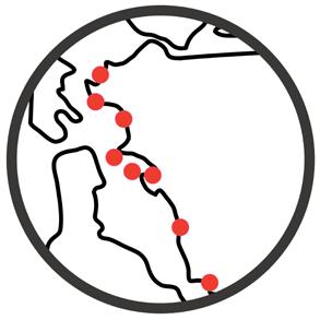
Why is the Bay Trail important?
The Bay Trail is a planned 500-mile pathway that circumnavigates the region’s shoreline and provides a crucial link connecting people and communities to parks, open spaces, schools, and transit opportunities. The Bay Trail is integrated into the landscape and often is built upon levees and other types of infrastructure that protect inboard resources like marshes, highways, and even residential and industrial areas. In many cases, that infrastructure is not designed to accommodate the impacts of climate change and sea level rise. The Park District manages 55 miles of shoreline in the region’s East Bay, which includes parks and segments of the Bay Trail serving as critical recreational spaces and commute corridors in a heavily urbanized region. The Park District recognizes their parks and trails are not immune to threats of climate change and these assets will become inaccessible to the community due to inundation, if they do not determine the vulnerabilities and proactively respond to the threats. The Park DIstrict also recognizes the partnership and coordination challenges facing the region as multiple stakeholders responsible for managing the shoreline must work together to adapt.
Approach
The RAAPP evaluates the vulnerabilities facing the East Bay’s shoreline and provides guidance for prioritizing nature-based adaptation projects to provide multiple benefits for the region.
The plan is focused on balancing goals related to advancing ecological restoration, recreation, critical mobility, and building important interpretive educational opportunities.
It introduces conceptual models of shore response to sea level rise and adaptation strategies for the diverse shore types found along the East Bay. Ultimately, the information presented in this document is meant to support trail-specific adaptation approaches taken by the Park District and key partners to strengthen shoreline resilience along the Bay Trail.
Regional tools, such as the San Francisco Bay Shoreline Adaptation Atlas (Adaptation Atlas) developed by the San Francisco Estuary Institute (SFEI), identify possible nature-based adaptation strategies around the Bay Area shoreline for Operational Landscape Units (OLUs). The RAAPP builds upon the Adaptation Atlas, presenting broad adaptation guidance for natural systems and the Bay Trail, downscaling the range of appropriate nature-based adaptation measures along the East Bay shore.
Nature-based shoreline treatments are emerging as an alternative to traditional, engineered structures, however, they remain a relatively young field. Coastal managers and planners need specific, place-based guidance considering the range of environmental settings naturally found in that region and large-scale human modifications. (Note: “placebased” refers to a scale that can be defined by specific or unique processes and conditions at the site level that are considered relevant in analysis and planning).
The RAAPP identifies which segments of the Bay Trail within the Park District's jurisdiction need the most immediate attention and will provide a vision and recommended approach for future implementation.
VETERAN'S PIER IN ALAMEDA DURING A KING TIDE EVENT IN NOVEMBER 2020
Source: King Tide California Project

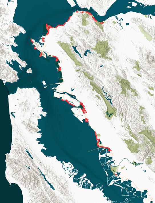
FIGURE 1-1: LOCATION MAP
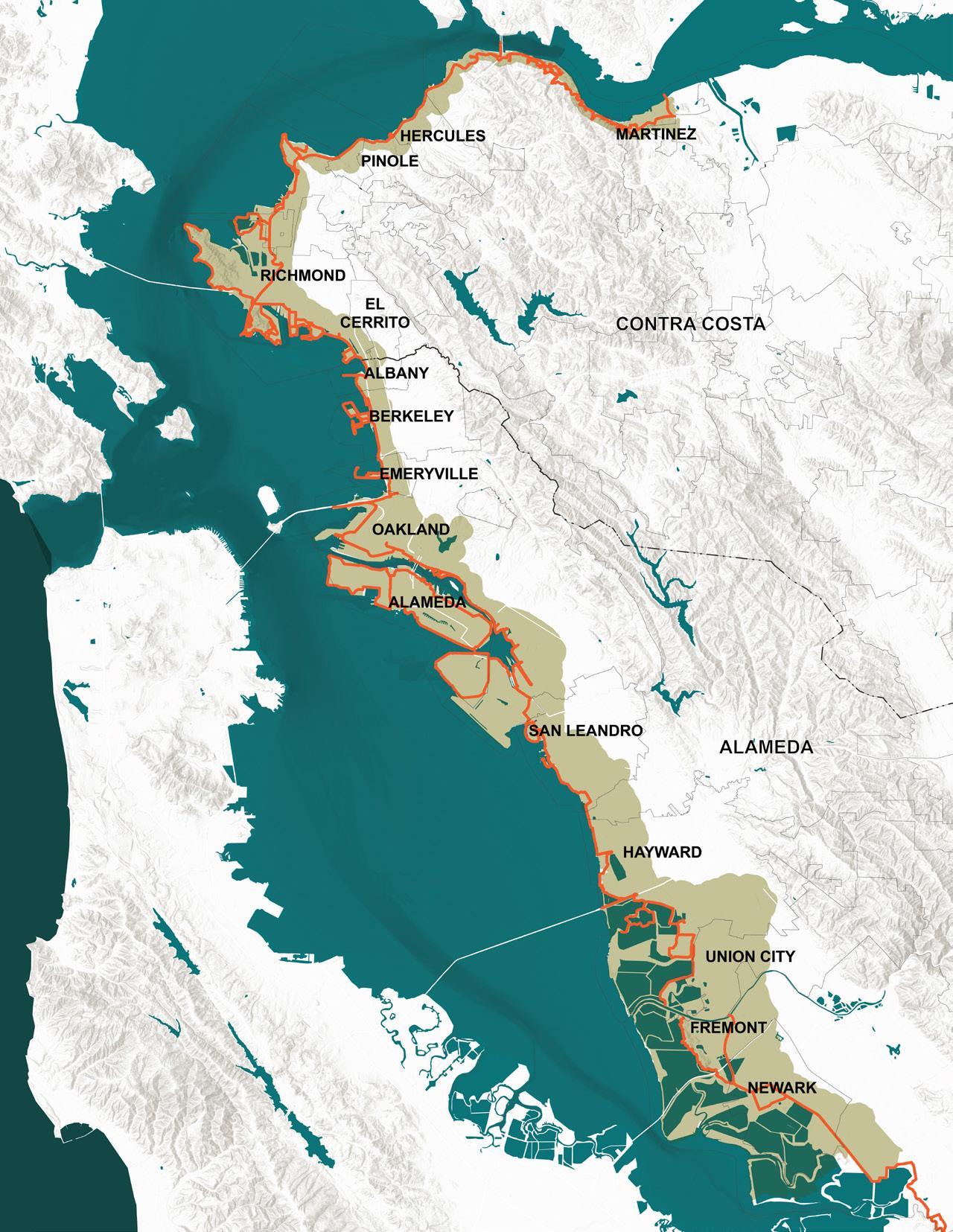

The study focuses on the segments of Bay Trail located within Contra Costa County and Alameda County. Figure 1-1: Location Map shows the extents of the study area, which encompasses the East Bay shore from BeniciaMartinez Bridge in the north and Coyote Creek in the south.
Contra Costa County has over 80 miles of Bay Trail, which are adjacent to tidal marshes, protected wildlife areas, recreational areas, as well as industrial and residential areas. Railway infrastructure is located along parts of the shoreline. The Bay Trail in Contra Costa County is connected to the North Bay via the Richmond-San Rafael Bridge, the Carquinez Bridge, and the Benicia Bridge.
Due to the urban setting, shoreline use in Alameda County is wideranging. Generally, recreation, light industrial, and commercial uses of the shoreline are common, with large swaths of residential housing located east/inland of the trail. The shoreline south of Oakland International Airport is comprised of recreational areas, salt and tidal ponds, wetlands, and wastewater treatment facilities. Several pieces of major transportation infrastructure connect the Bay Trail segments in Alameda County to other parts of the Bay, including the San Francisco-Oakland Bay Bridge, San Mateo-Hayward Bridge, and Dumbarton Bridge.
BAY TRAIL IN HAYWARD DURING A KING TIDE
Source: East Bay Regional Park District


Shoreline Scale
The overall analysis includes shoreline areas along both Alameda and Contra Costa counties, to understand varying shoreline conditions, land use development patterns, ecology, critical infrastructure, transportation network, economic activities, ongoing projects and plans, and most importantly, coastal hazards associated with sea level rise.
Eight Priority Sites
Based on the existing shoreline conditions analysis and established project goals and priorities, eight sites located along the regional shoreline were examined in an in-depth risk assessment. The team created evaluation criteria to compare Bay Trail segments based on exposure to flooding, landscape response to flooding, and potential impacts that may result from flooding both in the near-term and long-term considering sea level rise. Ultimately a weighted list was developed to identify tiers of first, second and third priority sites ranked according to risk.
Three Prototype Sites
From the list of eight priority sites, three sites were identified in collaboration with the Park District team as sites to explore a broad range of adaptation concepts and approaches across the East Bay. This visioning process begins to develop a range of possible approaches that could inform a regional response to future sea level rise impacts.
The sites include Alameda Point, McLaughlin Eastshore State Park, and the Martin Luther King Jr. Regional Shoreline.
MAP OF BAY TRAIL OPERATORS
See detailed map in Chapter 2.
EIGHT PRIORITY BAY TRAIL SITES
See more details about the risk assessment and prioritization process in Chapter 2.


3 PROTOTYPE SITES - ALAMEDA POINT, McLAUGHLIN EASTSHORE STATE PARK, AND MARTIN LUTHER KING JR. REGIONAL SHORELINE
See detailed map in Chapter 4.
The SF Bay Trail RAAPP approach is structured around a process that explores the existing conditions and predicted impacts of climate change and sea level rise across multiple scales. First, by looking across the full East Bay shoreline along both Alameda and Contra Costa counties, identifying the top at-risk zones and developing a Risk Assessment; and then by zooming in to exemplar focus areas to illustrate potential adaptation strategies and approaches that could be applied in multiple locations across the region. At each scale, and through the process, the analysis and design are guided by the Park District goals, and informed by ongoing conversations with key partners and stakeholders.
UNDERSTANDING CONTEXT
Sea Level Rise
Land Use + Demographics
Ecology
Infrastructure
Transportation
Economics
Ongoing Initiatives
The Park District Selection Criteria
1
SITE ANALYSIS: INVENTORY AND MAPPING SITE ANALYSIS: MEASURED IMPACTS
2
FULL SHORELINE
FIGURE 1-2: PROCESS DIAGRAM
EVALUATING RISK
Risk Assessment = Hazard x Vulnerability x Consequence
Hazards
Vulnerability
Consequence
PRIORITIZATION CRITERIA ADAPTATION STRATEGIES & PROJECTS THE PLAN
Risk Reduction
Stakeholder Input
The Park District Goals
Funding Feasibility
1
2
3
Site-specific Risk Assessment
Priority Projects
Site-specific Adaptation Strategies with cobenefits
Preliminary Design
Key Partnerships & Funding Strategies
Road map to future investments & Implementation Tools
RISK ASSESSMENT PRIORITIZATION FOR CONCEPTUAL DESIGN & ADAPTATION PLANNING ADAPTATION STRATEGIES
THE PARK DISTRICT SF BAY TRAIL RAAPP
4 5 6
8 PRIORITY SITES 3 PROTOTYPE SITES
PLANNING HORIZONS FOR A RESILIENT BAY TRAIL
A critical step in planning for the impact of future sea level rise is contingent on establishing clear horizons which define the level to which water rises, and projecting a timeline for the rise. This allows for consistent analysis across the Bay Area.
The following description relates the 3-foot and 6-foot sea level rise projections and compares it to local and state wide guidance for future planning in the area. The State of California provides guidance established by the Ocean Protection Council to develop planning guidelines for anticipated sea level rise. The most recent update to the State of California Sea-Level Rise Guidance was published in 2018. Table 1: Projected Sea-Level Rise (in feet) for San Francisco identifies the range of sea level rise projections associated with different levels of probability and risk aversion identified for each project.
Based on guidance received from BCDC, planning for a resilient Bay Trail should refer to the Medium-Risk Aversion 0.5% probability projection for High Emissions scenarios defined by state guidance. For planning purposes, this report identifies three and six feet of sea level rise to depict mid-century and end-of-century planning scenarios, respectively. The following chart in Figure 1-3: Planning Horizons identifies the ranges of sea level rise projections provided by the state over the next century and illustrates how the sea level rise depths depicted in this report relate to the anticipated time ranges. The planning scenarios are consistent throughout the Risk Assessment and the Priority Sites analyses.
More details are available in the memo attached in Appendix.
FIGURE 1-3: PLANNING HORIZONS
Source: Graphic by WRT, based on OPC’s State of California Sea-Level Rise Guidance, 2018.
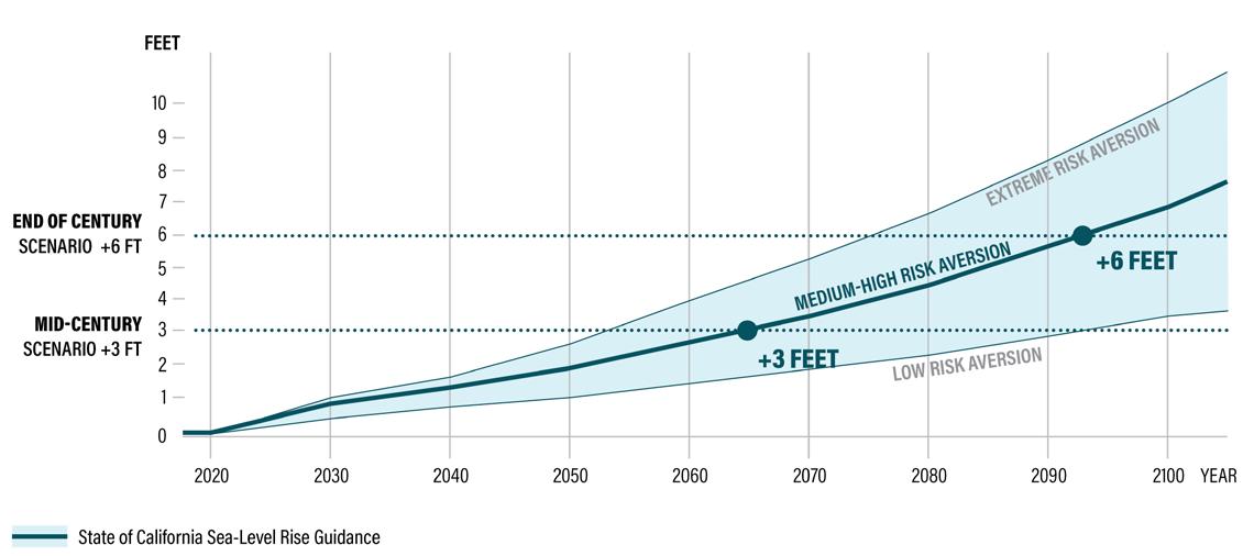
FIGURE 1-4: PLANNING HORIZONS
Source: Graphic by WRT, based on OPC’s State of California Sea-Level Rise Guidance, 2018.
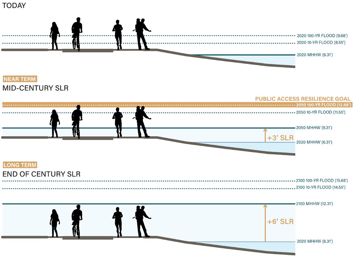
The cross-sections in Figure 1-4: Planning Horizons Illustrate the implications of sea level rise on the elevation of a resilient Bay Trail. For the purposes of this study, when applying sea level rise projections to a typical shoreline cross-section, the total water level builds from the existing mean higher high water level (MHHW) identified at the site and includes sea level rise and 100-year storm event levels in combination. Other factors like wave run-up conditions and erosion were considered and included in the risk assessment separately (See Appendix for more information). Projects undergoing design review with BCDC should provide an adaptation plan that provides public access that is resilient to a 100-year storm with sea level rise for the year 2050. For the purposes of this study, this will be the “Public Access Resilience Goal” for the mid-century scenario.
RICHMOND’S SHORELINE
Source: Photo by Micha Salomon, SFEI
A Regional Asset
The bay shoreline offers multiple benefits to the region, contributing a wealth of environmental, social, educational, and economic value.
Sea level rise poses a risk to shoreline access via the Bay Trail as well as the shoreline assets that border the trail. To fully gauge the losses resulting from future inundation, the broader risks involved, and to prioritize responses, it is important to understand the regional value of the shoreline. It is particularly important to understand the impacts of this loss on all bay communities, especially under-served and disadvantaged communities that will experience proportionally greater impacts due to loss of access to recreation, education, jobs, and housing.
The preliminary context analysis at the shoreline scale included understanding shoreline assets broadly categorized as below: • Ecological value • Recreational and public access value • Educational value • Critical infrastructure • Economic Value
The Bay Trail is a critical transportation infrastructure providing access to the shoreline, important connections between communities and recreational amenities, and a key car-free dependent mobility option.
Ecological Value
In the last century, we have lost 98% of SF Bay wetlands and sea level rise threatens the scarce habitats remaining. The remaining shoreline areas that support natural shores and marshes have a high ecological value due to this scarcity. Small portions of the shoreline benefit from protection afforded by natural features. However, the majority of the shoreline consists of former Baylands that have been filled and are vulnerable to flooding.
Some of the tidal marshes such as Arrowhead Marsh in the Martin Luther King Jr. Regional Shoreline, habitats in McLaughlin Eastshore State Park, and Cogswell and Oro Loma marshes offer significant habitat for endangered species.
In addition to protecting existing resources, the future adaptation of the shoreline along the East Bay offers opportunties for the Bay Trail to be integrated in larger areas of new habitat restoration.

BERKELEY MEADOW – McLAUGHLIN EASTSHORE STATE PARK, BERKELEY
Source: Photo by Sean Gin, Berkeleyside.

RIDGWAY'S RAILS ON SAN FRANCISCO BAY
Source: Photo by Edwin Mercado, Birdnote.
Recreational & Public Access Values
Crown Beach in Alameda is one of the few shoreline areas where the coast is fronted by a beach. A series of wetlands front the shoreline at McLaughlin Eastshore State Park and between Albany Bulb and Marina Bay. Additionally, while these beaches did not exist as part of the natural historic landscape, pocket beaches have formed around engineered shorelines (e.g. Richmond) along the East Bay shore. These pocket beaches are vitally important to captialize on in order to create nature-based shorelines. Although these beaches are artificial, they are still vital and important opportunities to reclaim the coastal area.

McLAUGHLIN EASTSHORE STATE PARK
Source: Photo by Five Nests, The Intrepid Tourist.

BIG BREAK MARINA, OAKLEY, CA
Source: East Bay Regional Park District
Educational Value
Facilities such as the Hayward Interpretive Center, and Crab Cove Visitor Center and Aquarium offer valuable educational opportunities focused on bay habitat, science, and environment. These centers operate primarily as resource centers for local schools' educational field trips to inspire a sense of appreciation and stewardship for the Bay. Additionally, the Park District also runs educational programs along the shoreline.

HAYWARD INTERPRETIVE CENTER
Source: Photo by Frank Balthis
CRAB COVE VISITOR CENTER
Source: the Saklan School Friday Blog

BAY TRAIL IN BERKELEY, CA
Source: Ride Chronicles

BERKELEY MARINA Source: Berkeley Marina
Critical Infrastructure
The Bay Trail has important transportation benefits such as providing a commute alternative for cyclists and connecting to numerous public transportation facilities including ferry terminals, light-rail lines, bus stops and Caltrain, Amtrak, and Bay Area Rapid Transit (BART) stations.
In many sections of the Bay Area’s existing shoreline, the San Francisco Bay Trail acts as the de facto first line of defense against coastal flooding and sea level rise. The consequences of damage or failure of structural shorelines could result in the loss of critical facilities, services and infrastructure that local communities and the greater region rely upon. The loss of connected Bay Trail segments could result in more people driving rather than walking or bicycling to their destinations and reduced opportunities to access the shoreline. Interrupted trail connectivity presents unique challenges to community access to nature and recreation for certain populations, in particular, people with disabilities or reduced mobility. Impacts to major transportation infrastructure adjacent to the trail make the need for collaboration even greater.
Economic Value
Economic activities such as economic drivers, retail main streets, light industrial and manufacturing activities and other businesses along the shoreline are at risk from impacts of sea level rise. Planning for adaptation and resilience is warranted to avoid and mitigate potential consequences.
The Park District staff and project team established project goals to guide the risk assessment and visioning process for future Bay Trail adaptation strategies and partnerships. The future shoreline could provide the region with multiple benefits that increase overall community resilience guided by the following goals:
1. RESILIENCE TO COASTAL HAZARDS 2. RESTORATION POTENTIAL 3. MINIMIZE RECURRING MAINTENANCE
4. ADJACENCY TO CRITICAL INFRASTRUCTURE 5. SERVING DISADVANTAGED COMMUNITIES 6. ACCESS TO NATURE, USER EXPERIENCE
7. FUNDING AND PARTNERSHIP POTENTIAL 8. ALIGNMENT WITH PARK DISTRICT MASTER PLAN GOALS AND PRIORITIES 9. REPRESENTATION OF A DIVERSITY OF COASTAL CONDITIONS AND GEOGRAPHIES
ARROWHEAD MARSH
Source: Photo by Jerry Ting


2
WHAT IS AT RISK?
The accelerating rate of climate change has made sea level rise a real and immediate threat to the coastal communities in California. The Bay Area is centered around the largest estuary on the west coast of North America. As the region has grown, the Bay shoreline has been substantially altered to accommodate growth, resulting in a large network of critical infrastructure, dense development including housing and industries, and protected natural lands within low-lying, flood-prone areas. The range of potential consequences from elevated water levels combined with the uncertainty of when these events will occur, drives the need and urgency for a coordinated, data-driven approach to plan effective near and long-term adaptation interventions along the shoreline.


