

Appendix 4:



















Appendix 4: Option 1A - modification request
Building coastal powerhouses - rooted in community, powered by partnership, driving local and regional prosperity
Introduction
The creation of a new unitary authority across the proposed boundaries is more than an administrative change; in the view of the cities, and their urban hinterlands, it is a chance to align places which are already intrinsically connected into a functional geography. This will allow for a strategic and integrated approach to addressing long-standing challenges and enable better services to support communities from Hythe to Eastleigh and Clanfield to Fareham. By integrating places that we believe are already economically and socially linked, this amended boundary option provides a platform to attract investment, deliver infrastructure more effectively, and plan services that reflect the realities of how communities live and the services they access.
How is this option different?
This appendix (Option 1A) is based on our proposal for Option 1 but requests a modification based on a few select boundary changes. This submission is conditional upon this modification being approved by the Secretary of State using the modification powers under the 2007 Act as this represents the stronger case for change. In the view of the Local Authorities that support this option, these boundary changes better meet government criteria, drive economic growth, create unitary authorities that reflect and serve cohesive communities, and realise the full potential of local government reorganisation.
Option 1A uses the district building blocks of Option 1 but with some, critical boundary changes to create stronger, more balanced unitary authorities that are set up to drive economic growth across the region.
The Isle of Wight and North Hampshire remain the same in all three options as supported by the rationale outlined in the core document.
Unamended Option 1 proposes:
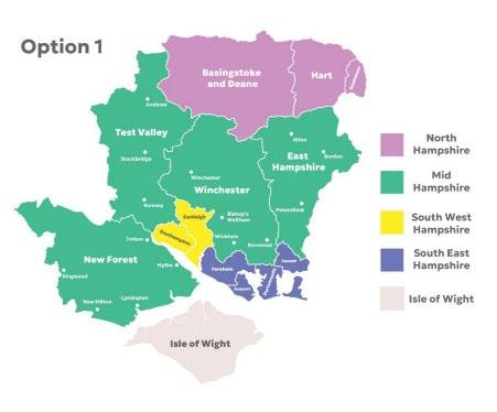
While Option 1 meets the government criteria, unamended we believe it misses the opportunity for the new authorities to fully drive economic growth. The option 1A proposed geography concentrates high-value sectors that already characterise the local economy and have the capability to thrive but would require the requested boundary modifications to maximise potential. An analysis of Location Quotients (LQs) for Gross Value Added (GVA), business counts and employment demonstrates well- established local specialisms that outperform national averages. These specialisms align directly with the priority sectors identified in the UK’s Modern Industrial Strategy, which focuses on areas with the greatest potential to enhance productivity and deliver sustainable, long-term growth.
In addition, Option 1A supports the creation of new unitaries with balanced populations across the mainland which will support devolution governance and improve the financial stability of the new city based unitaries by improving the equity of council tax and business rate bases.
While the proposed Mid-Hampshire council brings together similar rural communities, there are notable exceptions to this, with communities included that have more in common with the urban areas around the cities of Southampton and Portsmouth.
With a small number of specific boundary changes, the imbalance in proposed unitary populations across the region can be addressed, aligning communities existing natural linkages to the south coast’s urban hubs.
Option 1A proposes:
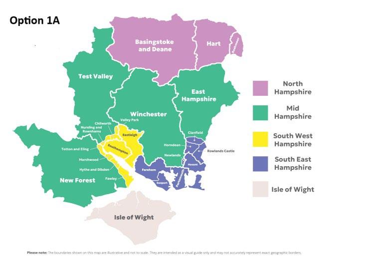
In the view of the cities and their urban hinterlands, there is a compelling case for some select boundary changes as detailed below.
Option 1A recommends the following select boundary changes from the Option 1 proposal:
• Move the parishes of Totton and Eling, Marchwood, Hythe and Dibden, Fawley (currently under the New Forest District Council) and Chilworth, Nursling & Rownhams and Valley Park (currently under Test Valley Borough Council) to the proposed South West unitary.
• Move the parishes of Newlands (currently under Winchester City Council), Clanfield, Horndean and Rowlands Castle (currently under East Hampshire District Council) to the proposed South East unitary.
In making these suggested boundary changes, Option 1A establishes two dynamic new unitary authorities along the south coast designed to unlock growth, strengthen local leadership, and better reflect the way people live, work, and travel today. The carefully considered boundary changes are minimal yet meaningful, aligning with real communities and economic geographies rather than outdated historic lines. This is a forward looking, growth- oriented plan that builds stronger, more resilient councils better equipped to tackle future challenges and seize new opportunities with confidence.
The Option 1A proposed South West unitary boundary brings together Southampton, Eastleigh, the Waterside parishes of the New Forest as well as two parishes from Test Valley. This unifies the county’s main trading gateways, key transport arteries, docks and industrial and related infrastructure both sides of Southampton Water.
The Option 1A proposed boundary for the South East unitary option brings together Portsmouth, Havant, Gosport, Fareham and adjacent parishes currently in the districts of Winchester and East Hampshire, but where the clear economic and social centres of gravity for those areas are the city regions, rather than those areas where the characteristics are more obviously rural.
We believe that communities in the parishes that would become part of the new unitary authorities would benefit from remaining with their aligned urban centres, with much more common community interests reflecting where they live their lives, rather than being part of a new large rural authority.
“The creation of new unitary authorities on these proposed boundaries is more than an administrative change; it is a change to bring together a coherent economic area, remove long-standing barriers to growth, and enable better services. It is sensible to integrate places that are already economically and socially linked, and this proposal provides a platform to drive investment across existing city regions, deliver infrastructure more effectively, and plan services that reflect real-life’’
Who supports the option?
Eastleigh Borough Council
Fareham Borough Council
Hart District Council
Havant Borough Council
Portsmouth City Council
Rushmoor Borough Council
Southampton City Council
Key reasons for support
Driving growth through bold reform: a vision for our region’s future
Economic growth is central to the government’s national vision, and it is equally central to our vision for the future of our county. This proposal sets out what we believe to be the most effective local government arrangements to unlock and accelerate economic and housing growth across our region. Option 1A’s strategic vision for city-region growth clearly meets the threshold set by Government for changes to administrative boundaries.
Southampton and Portsmouth are the beating hearts of our regional economy, historic cities with thriving communities and dynamic industries. Building on their strengths, our proposal for Option 1A outlines the creation of two new coastal powerhouse unitary councils. These councils will be rooted in economically and demographically connected communities, supported by a small number of targeted boundary changes to ensure coherence and impact.
We believe Option 1A is the preferred boundary configuration to deliver councils which:
• Deliver services across a geography that reflects practical realities of local people.
• Have balanced populations and council tax distribution.
• Are designed to deliver economic and housing growth.
This option reflects the real-world patterns of how people live, travel, and work today (not how they did when the current boundaries were drawn in 1972), and aligns with the existing economic footprint of our communities. The split between rural and primarily urban areas reflects the differing priorities and challenges for each. It is a pragmatic yet ambitious approach that supports both local identity and regional prosperity.
Option 1A also represents the most balanced in terms of population numbers, council tax base and business rates per capita across the county. This will ensure new unitaries are set up to succeed with sustainable finances to build from.
We acknowledge the complexities involved in altering existing district boundaries. However, we firmly believe that these changes are essential to unlock the full potential of our region that can better support the new Mayoral County Combined Authority for Hampshire and the Isle of Wight.
How this proposal meets government LGR criteria
Criteria one: A proposal should seek to achieve for the whole of the area concerned the establishment of a single tier of local government.
Option 1A proposes four new unitary areas on the mainland plus the Isle of Wight remaining as an independent council:
1. South West: Southampton, Eastleigh and the Parishes of Totton and Eling, Marchwood, Hythe and Dibden, Fawley (New Forest) and Chilworth, Nursling & Rownhams and Valley Park (Test Valley).
2. S outh East: Portsmouth, Gosport, Fareham, Havant, and the Parishes of Newlands, Clanfield, Horndean and Rowlands Castle.
3. North Hampshire: Basingstoke and Deane, Rushmoor and Hart.
4. Mid Hampshire: Winchester, Test Valley and the New Forest, excluding the Parishes specified above.
5. Isle of Wight
This proposal reflects how the community and demographic geography of our area has changed since the current councils were established in the 1970s. For example, the growth of Southampton, Hedge End, Chandler’s Ford, Totton and other settlements has meant more people in the surrounding areas developing close links with the city, whether through work, leisure, shopping, education or accessing local services. The same is true for the area around Portsmouth where the investment in local transport and highways infrastructure over the last 50 years has led to new developments, across the wider area, which are better linked to the urban centre of Portsmouth. As a result, many of the communities in our proposal already have a close relationship with the cities and have similar challenges and ambitions for the area.
South West Unitary
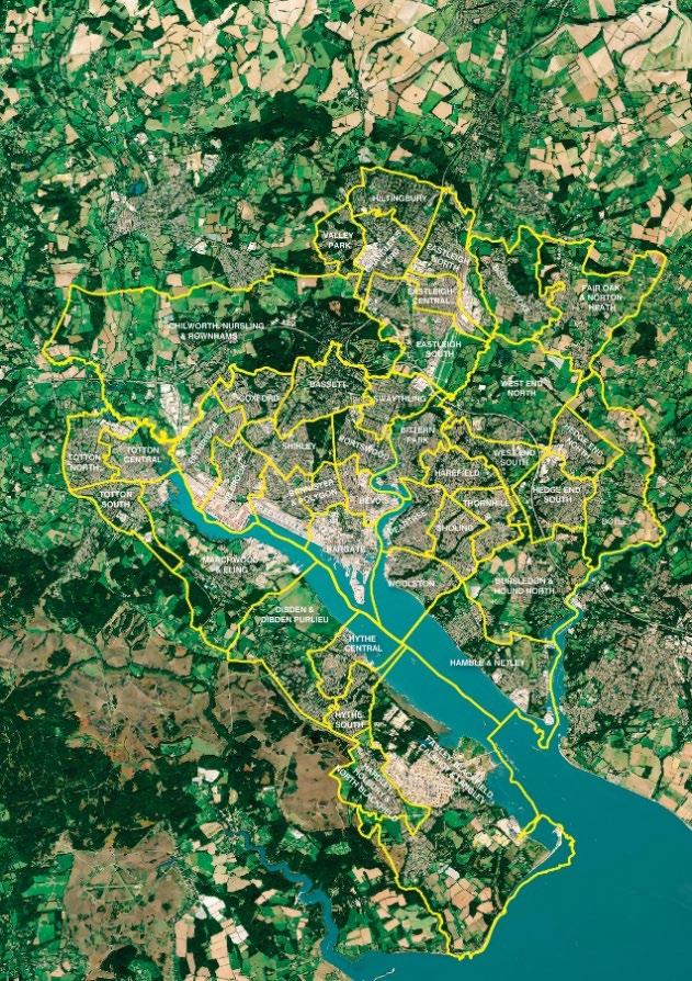
In addition to Southampton and Eastleigh, this proposal includes wards from both the Waterside area of the New Forest, and the lower Test Valley area.
To the West, the A326 forms a clear physical boundary between Totton and Waterside and the rest of the New Forest. An economic study commissioned by New Forest District Council sets out that the New Forest economy can be sub - divided into three sub -areas, Totton and Waterside, Core Forest and Coastal Towns and Avon Valley. Totton and Waterside is the smallest area of the forest geographically, but also the largest by population reflecting its significantly higher population density.
The Waterside is also the most industrialised part of the current district, hosting manufacturing and marine activities in Totton and Hythe and the Fawley oil refinery which is a major industrial employer. As such, the area has strong economic ties to Southampton through industrial and maritime industry either side of Southampton Water, and significant out- commuting from the area, primarily to Southampton and Eastleigh to the east and Dorset authorities in the west. The area’s economic profile is more reflective of the more urban area within the South West unitary, compared with the more rural makeup of the wider New Forest and proposed Mid Hampshire unitary.
To the north, the M27 marks a significant physical boundary for the proposed South West unitary. On a practical level, the urban areas of Rownhams and Nursling are directly connected to the Southampton city urban geography. Similarly, the Valley Park Parish is a continuation of the Chandler’s Ford urban area. While much of the population Chilworth is part of the Southampton urban area, the rest of the existing Chilworth, Nursling & Rownhams Parish also has close links.
South East Unitary
Parishes of East Hampshire proposed for inclusion in the South East unitary are those which lay south of the Butser Hill nature reserve, with all three parishes part of the continued urban geography along the A3(M) / A3 corridor.
The Parish of Newlands, currently located in Winchester, identifies strongly with Waterlooville as the closest town area, and serves two relatively new development areas with a strong connection to Waterlooville. Growth has meant that Newlands is a physical continuation of the Waterlooville area, giving a strong argument for bringing this Parish into the new South East unitary to ensure the local authority structure is harmonious and respects the local identity of those residents based around the Waterlooville area. Newlands Parish Council has stated that it is important that for any future unitary authority they should be in the same new authority as Havant Borough Council because of their natural links to Waterlooville.
The Parishes areas south of Butser Hill that have been proposed to be included in the new South East unitary authority align closely with the Portsmouth and South East Hampshire area. This is true for housing market area, for travel to work, for accessing major retail centres, accessing the health economy, education or the leisure and cultural offer. The characteristics of the area are much more similar to urban South East Hampshire than they are to the rural Mid Hampshire linked by the railway line and the A3(M) / A3 corridor.
Criteria two: Unitary local government must be the right size to achieve efficiencies, improve capacity and withstand financial shocks.
A more equitable distribution of population across new council areas is an integral element of ensuring financial sustainability of new unitaries and relative parity of representation both locally and on the new Mayoral Combined County Authority (MCCA).
Excluding the proposed North Hampshire unitary as it is the same across all options, the Option 1A proposal offers the smallest population differences between the three remaining councils and aligns most closely with the government’s stated criteria of councils of around 500,000.
The table below shows the population projections for proposed unitary councils for the three options.
Creating unitaries with greater population parity also increases financial stability across the region by creating more equal tax bases and opportunities for economies of scale.
Analysis of council tax projections identifies Option 1A as the most balanced with the lowest variance between the council tax bases of the proposed unitaries. Similarly, Option 1A is projected to have the smallest difference in average band D council tax.
Together this means Option 1A provides the most equal council tax rates for local residents, and the most equal council tax base for each new council.
The same is true for business rates, with business rates funding per capita projected to be the most equal in Option 1A .
Criteria three: Unitary structures must prioritise the delivery of high quality and sustainable public services to citizens.
This proposal builds on the principles and detail of public service delivery set out in the main business case. As existing unitary councils both Southampton and Portsmouth City Councils’ have the experience of the delivering the full range of high quality and sustainable public services. Underpinning both the existing councils is a commitment to driving local economic growth, not just to provide new skills, employment and housing for residents, but also to contribute to the financial sustainability of the cities and councils.
The proposed South West and South East unitaries are built on geographies with clear economic and social links with the existing cities and are designed to drive financial sustainability better able to withstand financial shocks.
South West
The South West unitary geography offers a strategically located, high-performing economic hub, uniquely positioned to drive growth across the wider region, while balancing the distinct needs of communities across the area. It benefits from a series of competitive advantages:
• Europe’s busiest cruise port and the UK’s second-largest container port.
• A maritime sector with 1.8 times the national average job concentration.
• An emerging life sciences hub centred around University Hospital Southampton.
• A coastal-industrial corridor delivering energy, advanced manufacturing, and green innovation.
• Access to two universities and a range of specialist training providers, underpinning a skilled workforce and innovation ecosystem. The proposed South West boundary brings together several strategic economic nodes under one authority. These nodes are currently split across administrative lines in Southampton, Eastleigh and the New Forest, limiting their impact and complicating investment and planning decisions. These include:
• City Centre & Docks
Southampton’s docks are the UK’s leading port for cruise and container freight, contributing over £2.5bn GVA annually to the UK economy. They support around 45,600 jobs nationwide, including significant supply- chain impacts in the West Midlands automotive sector. Bringing the port and its hinterland into one governance structure will unlock new efficiencies and growth.
• Southampton Airport
A key regional gateway and growth zone, the airport contributes £96m GVA and supports 1,390 jobs (2023). Its direct link to the Navigator Quarter Freeport site means improved coordination could unlock thousands of new jobs and millions in retained business rates.
• Maritime Gateway
Anchored by the Solent Freeport, this hub drives 26,000 jobs and £2bn into the local economy, with significant spillover benefits nationally. Over £1.35bn in private investment has already been committed, with plans to double cruise traffic to 4 million passengers by 2030. Importantly, the Freeport’s footprint spans across the proposed geography; bringing these sites under a single unitary would resolve fragmented oversight, enabling a more joined-up approach to planning and delivery of innovation corridors and infrastructure.
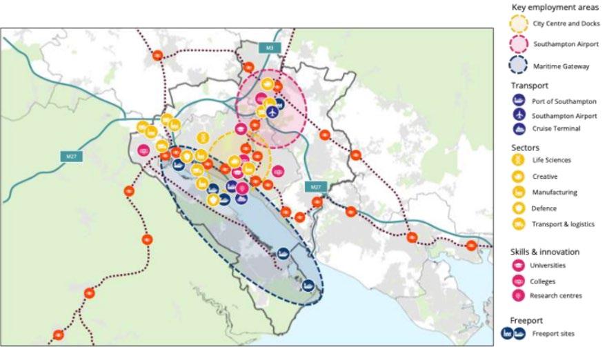
The image above shows the key employment areas, assets and transport infrastructure across the Option 1A geography.
South East
The proposed boundary for the South East option brings together Portsmouth, Havant, Gosport, Fareham and adjacent Parishes currently in the districts of Winchester and East Hampshire, but where the clear economic and social centres of gravity for those areas are the city regions, rather than those areas where the characteristics are more obviously rural. The key benefits for the South East arrangements anchored around the Portsmouth region are:
• Bringing together a strong functioning economic cluster, and associated travel to work area.
• Following the natural geography of the region, linking those areas south of Butser Hill.
• Creating a region with opportunities for growth.
• Following the transport infrastructure corridors associated with the A3(M) / A3.
• Creating a cohesive area for local communities, linked in with provision of services including health services.
• Reflecting education catchment areas including for example the University Technical College and also with significant access to the University of Portsmouth.
The proposal reflects the extent to which Portsmouth functions as the engine-room of the local area with people in the surrounding areas developing close links with the city - whether through work, leisure, shopping, education or accessing local services. As a result,
many of the communities in our proposal already have a close relationship with the city and have similar challenges and wishes for the area.
Delivering high- quality public services in the South West and South East
Both the proposed South West and South East unitaries incorporate an existing unitary authority (Southampton City Council and Portsmouth City Council) with experience of delivering adult social care, children’s services and planning for changes in population and demand. Southampton and Portsmouth Children’s Services were both rated 'Good' by Ofsted in 2023. This experience will be directly transferable to the new unitaries, building on strong foundations to establish new services tailored to the needs of their communities.
Health
Across the region there are significant health inequalities, driven by similar determinants including poverty and deprivation. There is good evidence that residents in the proposed footprints already look to the major cities to access many public services, including the NHS. For example, analysis by the Office for Health Improvement and Disparities (OHID) (data from 2020) shows that in the South East unitary area, 84-88% of patients in proposed additional wards attend Portsmouth Hospitals NHS Trust. This compares to 70% for the MSOA immediately to the north, 39% for the parish to the west, and 24% for the MSOA bordering to the east.
In the South West the same data suggests over 90% of patients in all of the Test Valley and New Forest wards proposed for inclusion in the new unitary attended the University Hospital Southampton NHS Trust, with lower levels in wards outside of the new proposed unitary boundary.
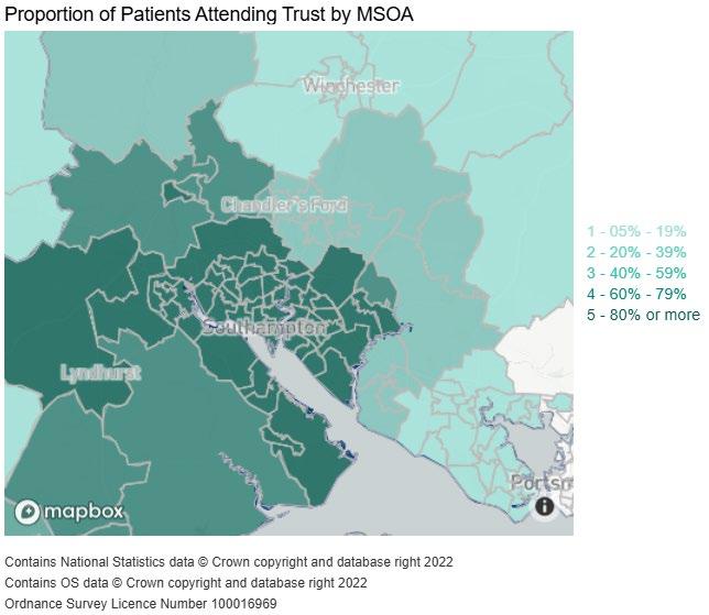
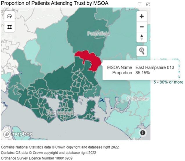
The two images above show the NHS Acute (hospital) Trust catchment populations – Office for Health Improvement and Disparities (OHID).
Education
Close relationships between the areas also exist in further and Higher Education provision. For example, 31.5% of 16 or 17 year-olds living in Southampton currently in education, employment or training are studying at a college outside the city but within the proposed South West proposed unitary, and these young people are using well established public transport links to do so. The link between the proposed geographies and existing service use demonstrates how people in proposed additional wards already access services within the new unitary boundaries.
The closest Further Education College for students from the three East Hampshire Wards and Newlands are the two southern campuses of the Havant and South Downs Colleges which also have high student numbers from the rest of the South East Unitary area.
Travel
While new unitaries will seek to provide services close to communities, the availability of strong transport links across the proposed South East and South West unitary footprints, ensures residents are able to access services across the proposed unitaries. Strong travel to work patterns also drives economic and employment growth.
For example, in the South West, the existing bus network links all the proposed South West area configuration as shown below. Travel to work data also highlights close transport connectivity across the proposed South West unitary footprint.
The 2021 Census shows that 62.7% of people who commuted into Southampton travelled from the New Forest, Eastleigh, or Test Valley, reflecting close economic geography and location of jobs. While based on 2011 census data, the map below shows that there is a higher concentration of people from the relevant Waterside and Test Valley parishes travelling into Southampton than from the wider districts.
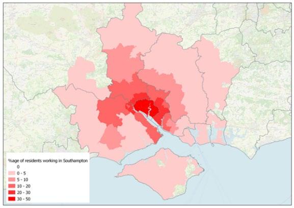
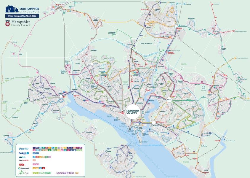
The images above show the travel to work patterns in Southampton, Map of existing bus network in South West covering all of the proposed new unitary area.
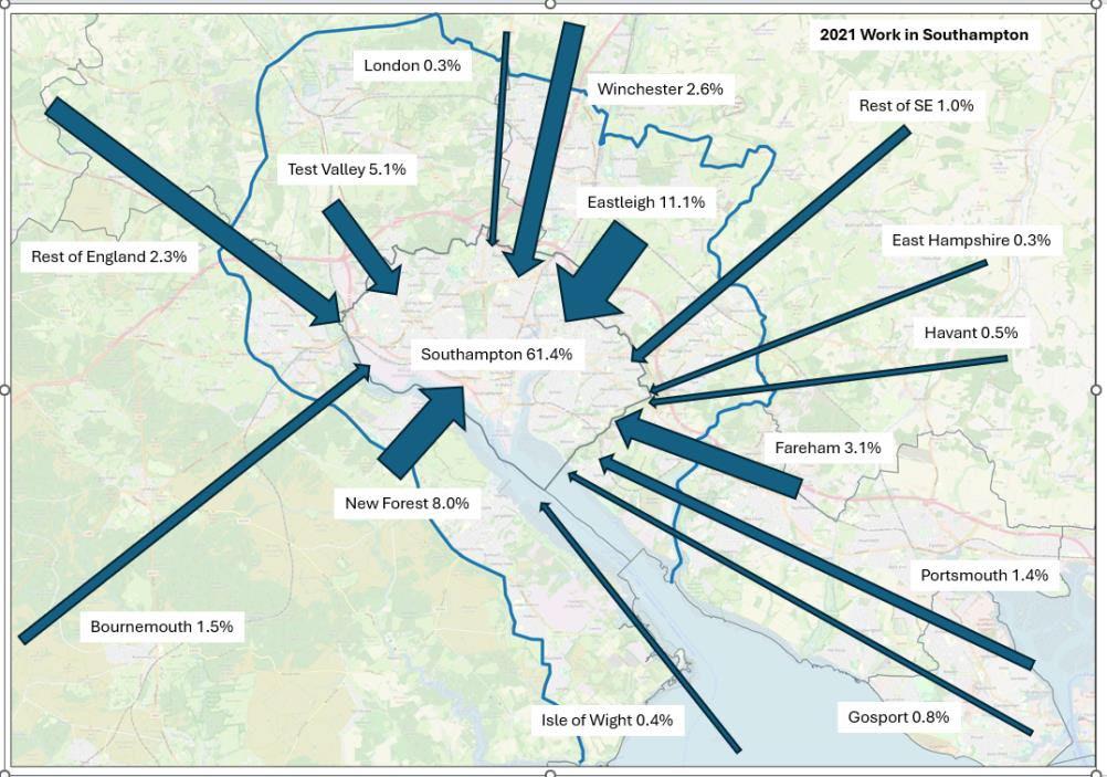
The image above shows travel to work patterns in Southampton.
Similarly in the South East, overall patronage on routes bus routes (Portsmouth - Wecock Farm) and 8 (Portsmouth - Clanfield) linking the city with parishes proposed for inclusion in the new unitary, is in the order of 100,000 journeys per month (+/- 10-15k per month depending on seasonal demand etc) on each route, equating to around 200k journeys per month combined. Those originating at the far end of the route and travelling into Portsmouth is estimated to be 5-10% of this total, equating to around 20k journeys.
From the 2021 census that looked at the issue, we can also see that the typical daily commute flows (outbound journeys only, i.e. starting from census zones in the fringes of Waterlooville) to Portsmouth itself, and to the wider areas of Havant, Fareham & Gosport are around half of all journeys made.
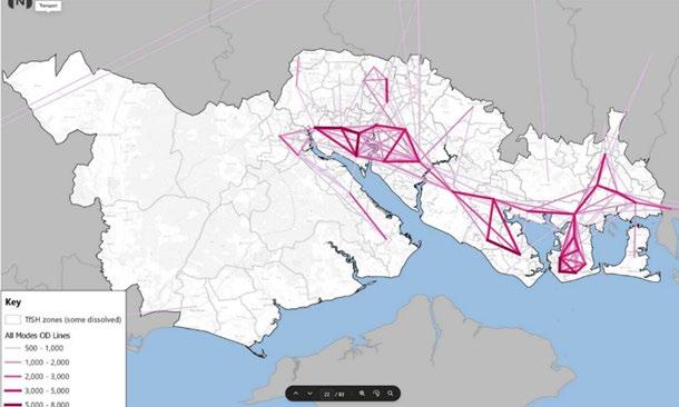
The map below illustrates the largest overall travel flows and highlights significant travel demand from areas proposed for inclusion in the South East unitary. For example, there are an estimated 1,000-2,000 trips a day from Horndean/Cowplain to northern Portsmouth
and 400-600 highway trips a day from the Clanfield area. These areas also have higher interaction with central Havant and Waterlooville, which in turn have significant interaction with Portsmouth.
The image below shows a map of trip matrix from Solent Sub Regional Transport Model (Solent Transport).
Criteria four: Proposals should show how councils in the area have sought to work together in coming to a view that meets local needs and is informed by local views.
The engagement activities outlined in criteria four of the core document outline the breadth of activity that that has been undertaken across the South East and the South West to date, recognising there is more to be done as we move forwards to understand and address concerns from across our communities and to articulate the benefits of the new unitary structures.
A survey that was undertaken on behalf of 12 of the region’s authorities gave residents across the region the opportunity to share their views on LGR options. The overall response rate was <1% and from a relatively narrow demographic, and while the survey showed that
Option 1A was the least supported, it also highlighted that it was the least well understood. Whilst there was a higher response rate in New Forest and Test Valley, these were still low percentages of the population (c2%) and may have been impacted by the concurrent publicity campaign against the option.
It is also worth noting, that whilst the sample size was small, that more respondents from Newlands parish in Winchester supported than opposed the boundary change option.
The survey showed residents in the parishes that would be impacted by boundary change were concerned about losing their rural character, increased urbanisation, and reduced influence over decisions. These concerns are something that would need to be more clearly understood and addressed as we move forward.
Residents felt there were:
Positives around
Aligning more urban areas with Southampton/Portsmouth, which may mean better service delivery for those areas.
Better reflecting reality for those who live in those areas and linking them to where they access services.
Those living in semi-urban areas being served by a council that better reflects their needs.
Negatives around
Disruption to those living in the affected areas.
Fragmenting existing communities. Particularly when it comes to separating the New Forest from the Waterside, which is seen as integral to the identity of the area.
Residents in affected areas losing local representation and influence in decision-making.
Criteria five: New unitary structures must support devolution arrangements.
The balanced population spread across the unitary authorities as proposed in this option helps ensure a fairer representation within the Mayoral Combined County Authority (MCCA) by creating governance structures that reflect the true demographic and economic diversity of the region representing urban and rural communities. This balance avoids dominance by any single area and ensures more equitable decision-making power across the MCCA.
This proposal is rooted in the existing economic areas across the South East and South West Hampshire, building on functional economic areas and grouping places with shared characteristics.
By creating unitary authorities that are predominantly urban (such as those encompassing Southampton, Portsmouth, and Basingstoke) alongside more rural and town-focused areas like mid-Hampshire and the Isle of Wight, the MCCA can attract stronger and targeted investment. This approach reduces competition for funding within the region by aligning development priorities based on local needs and economic profiles. It also enables infrastructure decisions to reflect the diversity of the areas, for example, urban-focused investments where population density and economic activity are highest, alongside rural development initiatives that support sustainability and quality of life in less densely populated areas.
This balanced and cohesive approach supports the government’s devolution goals by fostering stronger local leadership capable of driving tailored economic growth and prosperity. The Solent region, comprising these unitary authorities, has a strategic growth ambition aligned with national growth priorities as set out in the UK Industrial Strategy and UK Invest, highlighting the area's potential to become a globally significant maritime and economic hub. Coordination across these authorities fosters a unified identity and capacity for innovation and investment, amplifying local voices in negotiations with national government and other stakeholders.
In summary, this population-balanced, economically coherent proposal underpins the principles of devolution by ensuring fair representation, boosting economic growth in key urban centres, supporting rural communities, optimising investment, and enabling infrastructure development that reflects local realities. This ultimately empowers the MCCA to deliver sustainable, equitable, and regionally tailored outcomes for all communities across the region.
Criteria six: New unitary structures should enable stronger community engagement and deliver genuine opportunity for neighbourhood empowerment.
Given the existing place -based links, a new unitary would be well placed to develop strong arrangements to involve and empower local neighbourhoods.
As demonstrated in the response to criteria three above, there are clear similarities and links between the communities in Southampton, Eastleigh, the Waterside and lower Test Valley wards as areas with significant urban characteristics. Bringing these communities together gives the opportunity to address similar challenges and opportunities.
While varying in form, there are strong examples of good practice community involvement and empowerment in the area which could be built on across the Option 1A footprint. In Eastleigh, Local Area Committees work closely with a wide range of community partners
including schools, colleges, community groups, youth partnerships and business groups to champion the local area, determine local levels of council services and deliver local community priorities.
Similarly, Hythe and Dibden, Totton and Eling, Marchwood, and Fawley all operate town or parish councils ensuring local voices and perspectives area heard in decision making. Our proposed unitary would create a meaningful democratic forum for the Waterside area, ensuring that local voices continue to be heard. Similar arrangements are in place in the parishes proposed as part of the new South East unitary.
We will build on these existing arrangements and design any new community involvement and empowerment arrangements with communities, respecting local identity, history and needs.
Any arrangements would be developed to meet the government’s neighbourhood governance ambitions as set out in the Devolution and Community Empowerment Bill and subsequent guidance.
Closing Statement
Option 1A presents a bold yet pragmatic vision for local government reform in Hampshire. It is one that reflects the realities of how communities live, work, and connect today. By aligning governance with functional economic geographies and travel-to -work patterns, this proposal offers a coherent framework for delivering sustainable public services, driving inclusive growth, and empowering local communities. It is a future-focused solution that balances ambition with practicality, ensuring that new unitary authorities are equipped to meet the challenges of tomorrow while staying rooted in the identities and needs of the people they serve.