7 minute read
CHASING WILDFIRES FOR SCIENCE


CHASING WILDFIRES FOR SCIENCE
MOBILE PLATFORMS HELP RESEARCHERS STUDY WEATHER
Advertisement
BY CRAIG CLEMENTS
When thinking of tornado and hurricane research, meteorologists immediately envision mobile radars and storm chasers tracking thunderstorms or C-130 hurricane hunters penetrating into the eye of the storm to determine its intensity.
But when we think of wildfires, these technologies have been absent until recently.

In 2012, The Fire Weather Research Laboratory at San Jose State University mounted its Doppler lidar, a laser-based radar that detects aerosols and smoke in the atmosphere, on the back of a Ford F250 pickup truck. Equipped with an automatic weather station mounted on a rack above the truck and a weather balloon system, the California State University Mobile

Atmospheric Profiling System or CSU-MAPS was born.
The lidar is leveled using an airbag frame system mounted in the bed of the truck that also stores up to three helium cylinders for weather balloons. The truck is equipped with wifi so data can be uploaded to the web and sent to Incident Meteorologists (IMETS) and Fire Behavior Analysts (FBANS) when requested.
This nimble offroad platform changed the way fire weather is monitored at incidents. Between 2013 and 2019, more than 35 wildfires were sampled with the MAPS leading to several new and unprecedented observations of plume dynamics and other fire weather phenomena including pyrocumulonimbus, winds generated by smoke shading, turbulent
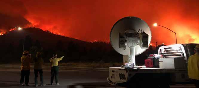
Radar taking measurements on Aug. 15, 2020, during the Dixie fire. San Jose State University graduate students monitoring fire behavior. All photos by Craig Clements.
properties of wildfire plumes, and fire generated vortices. These observations were made during a small field campaign called RaDFIRE-Rapid Deployments to Wildfires Experiment, funded by the National Science Foundation. From these experiences, it was demonstrated that applying storm chasing techniques to wildfires can be successful. There is one caveat and a big one—all San Jose State University personnel have to be red-carded (U.S. federal fireline qualifications), which is a requirement of incident management teams.
In 2019, San Jose State University acquired a new tool that transformed our wildfire monitoring capability, Doppler radar mounted on a second truck. This facility is quite amazing as it is specially designed for studying clouds and the smaller ash particles found in wildfire plumes. The radar was designed and built by Prosensing, Inc. and is a Ka-band dual polarized radar, which means it transmits two pulses, one horizontal and one vertical, which allows for the particle shape and type to be determined. The radar has been deployed to eight wildfires and the measurements obtained from it are groundbreaking. The radar truck is equipped with auto-leveling jacks that can level the truck and radar in three minutes while the radar is booting up. Observations can be taken in as little as three minutes once on site; this provides a much safer platform for the fire environment as the truck can leave quickly as well. Additionally, the radar has a


much longer range than the lidar, so researchers can scan the plume faster, in greater detail and at a safer distance from the fire. Another unique aspect of the radar is that because it scans faster and is quicker to start up, it is better at general reconnaissance of the fire environment than the lidar. The radar has really changed how researchers monitor fires and fire weather, and allows us to see what’s going on inside the plume.
Now, the team deploys both the lidar truck and the radar at an incident, providing a much more complete observational suite for understanding fire weather and plume dynamics. While the radar is rapidly scanning the plume and tracking the fire-induced winds inside the plume, the lidar is profiling the winds vertically up to one kilometer above the truck. So, for the first time, we can measure the ambient winds not only at the surface but much higher in the atmosphere while simultaneously observing what the plume and fire are doing. In addition to the remote sensing systems, the team has the ability to launch radiosondes – a meteorological package that is attached to a weather balloon, which is about one meter in diameter. Radiosondes provide profiles of the atmosphere through the troposphere and lower stratosphere and provide measurements of temperature, humidity, wind speed and wind direction. These observations and data can be very useful for IMETS and the trucks are often requested for large incidents, particularly
SJSU team deployed to the Dixie fire in 2021.
Lidar and radiosonde system deployed during the King fire in 2014.
because the radiosondes can show where temperature inversions are present. For example, during the Detwiler fire near Yosemite in 2017, the team was asked by the IMT to launch weather balloons for just that purpose – to determine the strength of the inversion and whether the smoke would lift in time to allow air suppression activities to begin. Coupled with the lidar data of the smoke depth and vertical wind profiles, these observations allow us to see through the smoke and get a sense of the conditions above the socked-in smokey valleys that so often occur in mountainous regions. The lidar in this case provides a new set of eyes to the IMET.


While the ground-based assets are providing new and critical observations of the fire environment, we still need better observations of fire behavior. To address this need, we have developed a new airborne infrared fire imaging system that will be flown on an aircraft this fall. The high-resolution imaging system, developed by one of our faculty in the Wildfire Interdisciplinary Research Center at San Jose State University, allows us to see the fire in greater detail with less saturation so we can determine really hot areas of active spreading and not so hot regions behind the fire front. Additionally, new spot fires can be observed and tracked; this will allow critical fire behavior metrics such as fire rate of spread, heat release rate, and spotting to be monitored more completely. These images, coupled with the Doppler lidar and radar data, will provide for
the first time, observations that link plume dynamics to fire behavior at an unprecedented detail.
These tools and field deployment strategies, while not new to the severe weather research community, are helping to break ground in wildfire science and provide unprecedented situational awareness for IMTs. For large fire incidents, the technology and protocols are well developed, so IMTs should really be taking advantage of this. The San Jose State University team and facilities are available by request through the Tahoe National Forest or by contacting me directly. The team will travel anywhere in the western United States.

ABOUT THE AUTHOR
Craig Clements is professor and chair in the Department of Meteorology and Climate Science at San José State University and director of the National Science Foundation I/UCRC Wildfire Interdisciplinary Research Center. He leads research on fire weather, extreme fire behavior, fire-atmosphere interactions, and conducting wildfire field experiments. He teaches courses in fire weather, wildfire science, mountain meteorology, climate change, and meteorological instrumentation. He received his PhD in geophysics from the University of Houston, his MS in meteorology from the University of Utah, and a BS degree in geography from the University of Nevada. His research has been featured in PBS NOVA, Rolling Stone, The New York Times, Time, CNN, and Scientific American.

Preparing radiosonde during the King fire in 2014.
San Jose State University researchers controlling the radar and watching data during the Kincade fire in California in 2019.
Typical deployment with both trucks positioned close together making co-ordinated measurements, during the Kincade fire in 2019.


