
4 minute read
The car in the city


The Fifteen Minute City (FMC) is an urban planning concept by which most daily necessities and services can be easily reached within a 15-minute walk or bike ride from any point in the city. Like Low Traffic Neighbourhoods and Clean Air Zones, the FMC has been attracting the interest of the media and the ire of activists who see it as a dystopian plot to limit our freedoms. In sedate Oxford, for example, there have been near riots in protest against initiatives to limit the impact of motor vehicles within the urban area.
So, what does the concept of the FMC actually involve? In the planning and development of an urban area, the objective would be to have as many facilities as possible within a 15-minute walk or cycle ride of every house. Residents would thus have the convenience of shopping, going to school, working, or relaxing close to home without the need to use a car. Is this really so revolutionary?
Advertisement
Widcombe Choir
Here are some of the reasons why local people love singing with Widcombe Choir:-
• Fun, friendly, good for body and soul
• A community, a good singing group
• Sing and forget your worries
Our Summer Term this year ends on 22nd May.
If you want to join our email list, see our section of the Widcombe Association website, or go to our own website https://widcombe-choir.mailchimpsites.com, where you can check Term Dates. Or just turn up.... you will be welcomed.
We meet upstairs at ...
Widcombe Social Club
Widcombe Hill, Bath BA2 6AA
In the early part of the last century, Garden Cities and New Towns were built from a similar premise. Nurseries and primary schools, shops, public spaces and play areas, community buildings and bus stops were designed to be within walking distance for as many people as possible. It makes sense for these facilities within easy reach of people’s homes, but it should be a guideline and not a dogma. The same aims can be pursued within existing towns and cities.
Low Traffic Neighbourhoods are simply a new interpretation of the Environmental Areas expounded by Professor Sir Colin Buchanan in his seminal report Traffic in Towns in the early 1960s. His ideas, in turn, were inspired by Sir Alker Tripp, an Assistant Commissioner in charge of traffic for the Metropolitan Police in the 1930s.
Both men wanted to limit traffic in urban areas to maintain acceptable environmental standards. Through-traffic would be eliminated from residential neighbourhoods. For Buchanan, it was important that the capacity of roads in urban areas be limited by noise and air quality thresholds rather than by engineering design criteria. It is 90 years since Tripp, and almost 60 years since Buchanan, but we have still to reach a consensus on these issues, even in the face of the climate emergency and a much better understanding of the dangers to health from traffic.
The initiatives currently being introduced by the council in Bath, including the Clean Air Zone and Low Traffic Neighbourhoods, are consistent with these concepts. However, their application requires pragmatism and common sense. It also requires a strategic view of how the various initiatives join together across the whole of the city. And, to be really successful, these ideas must be allied with genuinely effective public transport. Unfortunately, at the moment, we are moving backwards on that particular issue.
■ Mike Wrigley
Mapping the Green Belt
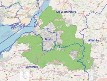
Green Belt is one of the best known planning policies and one of the least understood. The first Green Belt was established in 1938 to control the outward spread of London, safeguarding areas of green space between the fast-growing capital and surrounding towns and villages. In many ways, the policy was successful, but one of the consequences was that many of those towns and villages then expanded – adding to the numbers commuting to work in the capital.
In 1955, the UK’s local planning authorities were encouraged to establish green belts around their main towns to control the direction of growth, and to prevent urban sprawl and coalescence with neighbouring settlements. The plan was that Green Belt boundaries be defined in local plans and last for 20-25 years before being reviewed and adjusted to allow expansion (or possibly contraction) in light of changing needs.
The general public, however, became fiercely protective of ‘their’ Green Belt, seeing it as permanent and inviolable. These days, any plans to roll back boundaries (which may be necessary to allow for much-needed housing and infrastructure) are invariably opposed. Perhaps the mistake was in the 1955 wording – if a shorter timeframe had been stipulated, say 10-15 years before review, there might have been greater expectation of change.
The Green Belt in the West of England (as defined in the 1980 Structure Plan) was designed to control the pattern of development associated with Bristol and Bath, the main objective being to avoid coalescence or urban sprawl.
A major review of the boundaries followed in the early 1990s, but although land was identified as suitable for expansion to the north and west of Bristol, the special circumstances of Bath’s geography and heritage, emphasised by the designation of the entire city (including its setting) as a World Heritage Site, meant that little or no expansion could be permitted. In the most recent development plans, Keynsham has been identified to expand and there is hope that this will be suitably supported by transport infrastructure.
To add to the council’s difficulties, much of Bath (and all of Widcombe) lies within the Bath Conservation Area and is largely encompassed by the Cotswold Area of Outstanding Natural Beauty (AONB). There are limitations on what structures are acceptable – even works to trees require approval. The countryside is very much on our doorstep, but we should spare a thought for the council’s planners who have a far greater burden than most other local authority planning teams. ■ Jan Shepley


