4 minute read
Tramping Socks


Features:
* Double ribbed cuff – prevents sock slippage
Advertisement
* Added cushion and elastic support of Achilles tendon and arch
* Mesh ventilation zones –temperature and moisture control
* Nylon heel and toes reinforcements – increased durability plus added cushioning for comfort
* Flat toes seam – prevents toe irritation
* Cotton 66.2%, Spandex 14.8%, Dry Zone 19%
Men’s size: 9-13, Leg Length 17cm
Colours: Black, Blue, Brown
Womens size: 6-11, Leg Length 24cm
Colours Black, Brown
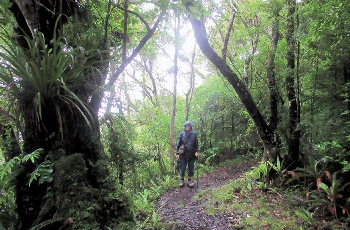
Two lowland walks in Egmont National Park
The Kaiaua Swingbridge Walk
.The Kaiaua Swingbridge Walk is a delightful experience on the Kaiaua Tramping Track that heads into the Pouakai Ranges. Not signposted this bridge is a short walk through the forest to view and if you wish wobble your way over.
Once again the track is uneven, knotted with exposed tree roots, narrow and muddy in patches mostly downhill and slippery if wet but worth the visit.
It is not well known to many visitors or locals due to the fact that it is not signposted from the road. It is single use, only one person at a time, but signposted to say so. The view of the swift flowing river below is a beautiful sight especially after heavy rain. There are steep wooden steps leading down to it.
The bridge is not for anyone who is frightened of heights or unsteady on their feet as it does sway with the motion of crossing it. Has high wire fencing to cling onto, not easy to take photos due to the movement.
Classed as a 30 minute walk from the car park it took us one hour and 40 minutes return due to spending time and enjoying the beauty and tranquility of the fast flowing water along with the the forest silence. Worth visiting. Once again the beauty of the rainforest on this mountain on all tracks and walks is a wonderful experience.
The car park for this walk is situated on the right hand side of the road further up from the parking area for the Ngatoro Track toward the visitor centre and is signposted as the Kaiaui Track and has only about six parking spaces on the side of the road. We were lucky there was a spare one. A short walk into the entrance there is another signpost stating Kaiauai Track. Take this one.
The entrance to North Egmont National Park is at the top of Egmont Road which continues all the way to the North Egmont Visitor Centre. Turn off at Egmont Village which is between Inglewood and New Plymouth. Signposted from the road at the junction. Important to plan and prepare your trip and be well equipped.
Beware of the weather as it can quickly change. I advise sturdy footwear for all walks. Many streams and rivers are unbridged. You can check with
Above: A damp misty track leading to the waterfall.
$26.95 plus $7 Shipping
Available
P
Ouch! Sore feet while walking?
Hikers Wool is 100% New Zealand wool. Cushion your feet to prevent pain, rubbing and blisters.


Buy online or at selected stockists
For more info visit www.hikerswool.co.nz the visitor centre for all information before setting out by phoning 06 7560990 or email egmontvc@ doc.govtnz Egmont National Park is managed by the Department of Conservation. A phone conversation is much quicker giving you more information by speaking to one of the lovely ladies at the visitor centre.
The parking at the visitor centre in the summer months is always full, especially at weekends and holidays and it pays to get there early to secure a space.
Lush rainforest on park’s lower slopes
The majestic and estitic volcano Mt Egmont, (2518m) is the central point of the 34,170ha Egmont National Park. Approximately 125,000 years old, it is the park’s most recent volcanic peak. Egmont National Park became New Zealand’s second National Park after Tongariro in 1900. Named Mt Egmont by Captain Cook, the traditional Maori name of Mt Taranaki is more widely used.
New Zealand’s oldest building within a national park is found at North Egmont. The historic Camphouse was originally used as military barracks in New Plymouth during the Taranaki Wars of the 1860’s.
The building was sledged to North Egmont in1891 for use as accommodation. The Camphouse has been restored and upgraded for backpacker accommodation, many of its unique historic features such as handwrought corrugated iron with rifle firing slits (loopholes) and tongue and groove timber panelling are still visible.
Lush rainforest on the mountains lower slopes is evidence of the park’s high rainfall. Dripping with moss and lichens it is sometimes referred to as ‘goblin forest’ on the higher slopes the forest gives way to dense subalpine shrubs and alpine herb fields.
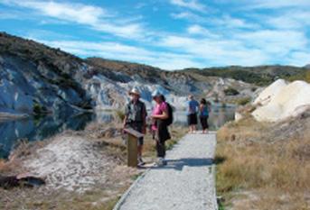
Two St Bathans walks
opportunity to walk past old sluicings and the remnants of the goldmining equipment that was used here - machinery that literally converted Kildare Hill into a lake.
It’s also a chance to experience the conditions that the miners had to work in: searing hot summers and freezing cold winters. Please protect yourself accordingly.
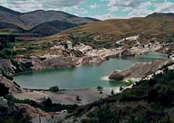
St Bathans was established in 1863 to service gold mines duirng the gold rush and is brimming with history. There is much to see and do including a walk around the scenic Blue Lake or admiring the historic buildings.
St Bathans is a popular side trip from the Otago Central Rail Trail. St Bathans township is situated at the foot of the Hawkdun and Dunstan ranges. The town allows you to step back in time to the gold mining days. Take a walk around the scenic Blue
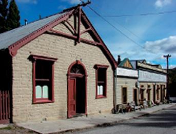
Historic buildings walk
St Bathans township historic buildings include the well known Vulcan
Hotel, St Bathans Hall, Post Office and Gold Office.
Lake that was created by goldmining or admire the historic buildings.

Blue Lake walk
Time: 30 minute loop track
This 2km loop track encircles the historic, man-made lake. It’s a great
The St Bathans Hall built in 1892/93 is typical of community halls built during the gold mining years, though rare in its large size. An original mural at the back of the stage adds a distinctive air of the past to the interior.
The St Bathans Post Office is another important landmark in St Bathans. Built in 1909, it was the third post office built on this site.
Fact file
To get there: St Bathans is located 60km north east of Alexandra off State Highway 85 (Alexandra to Ranfurly). A turn off sign is on the left.
At the town of St Bathans go off the main street to the DOC carpark; the track is nearby.
Above left: Looking down on the Blue Lake.
Above right: The historic St Bathans Hall.
Middle left: A walk on the Blue Lake path. DOC photos


