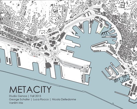
METACITY
Studio Genoa | Fall 2015 George Schafer | Luca Rocco | Nicola Delledonne Vanlim Ma
The Project The studio explores the forces that shape the built environment of Genoa, Italy. In the contemporary world, it is essential to design with insight and different perspectives when developing a transformative impact for the city. This studio engages with real-life conditions that interest the vice president of the municipality authority of Genoa. There are meetings and debates involving current project architects, port authorities, public authorities, and cultural institutions. The goal is to generate solutions that would make the city evolve as a self-sustaining economic organism. The large gap between the city’s land and privately owned industrial port creates a huge void that disables the life of Genoese thus hindering future growth compared to rapid changing forms of worldwide urbanization. The project focuses on structuring the physical environment into a socially, culturally, and ecologically sustainable habitat. It is reinforced by the exploration of other city typologies with particular focus on the renewed relevance of typological reasoning and experimentation to describe, conceptualize, theorize and ultimately project new ideas for and from the city.
The City: Genoa, Italy Genoa is an old industrial city that contains centuries of history and culture. Today, the city is complex due to the tension and division of land between the industrial port and the municipality. This not only makes the port inaccessible for Genoese, but it also prohibits most existence of public/green spaces for leisure purposes. Metacity Genoa Studio Fall 2015 investigates the urban framework through the means of experience, mappings, site sections, reviewing discussions with cultural locals and debates with port authorization. After analyzing the existing facts, with knowledgeable insight, we came to the conclusion that lands need to be given back to the Genoese for the city to become self-generating in terms of economic growth.
Liguria
Voltri
Pra
Pegli
Sestri Ponente
Airport
Centro Storico
Foce Boccadasse
Priaruggia Quinto
Nervi
Bogliasco Pieve Ligure
Coastal Variation
Water/Coastal Usage
Natural coast
Public Beaches
Public Dock/Overlooks
Genoa’s coast is naturally rocky and steep, resulting in a ribbon of cliffs running along the water’s edge. This makes them unusable for leisure purposes.
Beaches are not a natural feature in this region. Many of them are manmade. All the beaches are at least 45 miles from the city Genoa.
Public docks are few and far between. Many of these docks are small beaches which depend on the tide to launch boats.
Shipyard
Ferry Cruise Terminals
Industrial Port
The biggest shipyard is located in Genoa. They fix cruise ships and personal ships. It is one of the first things one sees when entering by sea.
Traveling by Ferry Cruises is one of the most popular ways to enter the city for tourists. There are four ferry terminals; that is half the city’s port.
Most of the port belongs to private owners. There are plans to increase the surface area for containers storage/shipment by building land into the sea.
This map divides the coast of Genoa’s metropolitan area by usage and accessibility. Five categories are shown, with two related to public uses and three related to city uses, inaccessible to the general public. The majority of Genoa’s coast is reserved for the Industrial port. In the historic port, Ferry/cruise terminals and the shipyard are the dominate features. Beaches are far from the city due to the polluted water from the industrial area. Public access to the water’s edge is limited, especially in regard to beaches, the majority of which are located down the coast to the east. These public beaches are small and often require an entrance fee. Sections of the coast not marked by a colored category are sections of cliffs and other natural features which are inaccessible for everyone.
Public Beaches Public Dock/Overlooks Industrial Port Shipyard Ferry/Cruise Terminals
Building Typology: Urban Fabric at Port The categorized buildings were determined by the approach and view of the buildings from both The categorized buildings the sea and main ground level highway. Frombythis were determined the mapping procedure, you have a ring of buildings approach and view of the in the Port Antico area that then morph modbuildings to fromaboth the sea ern city plan, focusing on the street instead of level the and main ground port to the left of the Lanterna. highway. From this mapping
procedure, you have a ring of buildings in the Port Antico area that then morph to a modern city plan, focusing on the street instead of the port to the left of the Lanterna. References: 2015 Port Authority of Genoa Industrial Handbook.
Institutional Residential Commercial Mixed Use
Passeggiata Access
Passeggiata
Because most of the area surrounding the Lanaccess does terna is privately used, public transportation not contribute to its accessibility. From the closest Because most ofisthe area bus stop, an additional 300m-400m of travel surrounding the Lanterna is still necessary before reaching the entrance of privately used, public the Passeggiata. Walking from a lift or the metro transportation does not requires even farther travel. contribute to its accessibility. From the closest bus stop, an additional 300m-400m of travel is still necessary before reaching the entrance of the West Bus Walking Line from a lift Passeggiata. or the metro requires Valpolcevera Bus Line even farther travel.
Central/East Bus Line Metro Nave Bus Ferry Lifts Bus Stop Metro Stop Passeggiata Entrance
0 100 300 N
600
Meters
1000
ort
Natural
Green Space: From Fort to Port This diagram shows the green space in Genoa from the fort area to the port area. It is important to notice that the urban growth is depleting the natural landscape of Genoa. The vegetation in the city can be separated into 3 groups: natural landscape, urban landscape, urban reversion.
Green Space Water
Urban Landscape
Green Space in Port This diagram focuses on the green space surrounding the port area in Genoa. It is important to notice that majority of the green space around the Lanterna is reverting back to natural landscape.
Urban Reversion Urban Landscape Urban Reversion
Separating Boundaries The diagrams explain the bounding conditions related to our site. There are strong separating conditions pertaining to geographical conditions (mostly portrayed within our site) and physical separating boundaries (along the sea port) that create barriers for the connection of people from the city to the sea but also persons at the sea port level to within the city itself. Natural Boundaries Natural/Port Boundaries Port Boundaries Topography
Port vs. Public Access This map illustrates the distinct separation between the city and the port and demonstrates the accessibility of the port to the public. The international boundary can be crossed through different thresholds by way of gate, railway, or motorway. Helping us to understand the accessibility of our site, this map gives us a better understanding of where there is a disconnect from La Lanterna to the rest of the city. Port Area Port Gates Port/City Boundary
Port vs. Public
Border Conditions Access 1.
2.
Genova, Italia This map illustrates the distinct separation between the city and the port and demonstrates the accessibility of the port to the public. The international boundary can be crossed through different thresholds by way of gate, railway, or motorway. Helping us to understand the accessibility of our site, this map gives us a better understanding of where there is a disconnect from La Lanterna to the rest of the city. References: 2015 Port Authority of Genoa Handbook.
Railway Port Area Motorway Port Gates Port/City Boundary Passeggiata Railway Motorway
1.
Terminal 2.
Passeggiata
La Lanterna
These separating boundaries correspond to the physical and natural boundaries such as the topography, the sea port edge and the isolated topography of the Lanterna. The physical separation from the mountain to the Lanterna was created by actually cutting out the mountain.
Diagram 1
Port edge
Topography & isolated Lanterna
Cut Mountain Wall
The separating boundaries shown here relate to the physical and visual bounding conditions that are prevalent around the port itself. These include the sea port edge, the elevated highway, and the urban city facade. These create a certain bounding condition to the sea and into the urban tissue.
Diagram 2
Port edge
Elevated highway
City wall
Diagram 3 City facade
Port edge
Elevated highway
Vehicular traffic
City wall
Here the diagram explains the conditions at the beginning of our site boundary. There is an overlap between both the geographic boundaries of our site and the bounding conditions found along the port creating a certain threshold to our site. This implies the difficulties of accessibility to entering our site or accessing the Lanterna, the final destination and key landmark of the city of Genoa. These bounding conditions include the mountain wall, elevated highway and seaport edge, but also introduce a secondary city facade element as well as the change in grade for vehicular traffic including underground traffic circulation. Examples
-No visible crosswalk -Highly dense street -Multiple streets to cross
-Closed off construction -No sign to La Lanterna
An Isolated Landmark This diagram shows the difficulty to get to a major landmark, La Lanterna, in Genoa, Italy. By looking at the pedestrian path, it is obvious that there is no continuity. Not only is it not continuous, there are major parts where the pedestrian path crosses major vehicular paths. This makes it difficult to get to the Lighthouse and shows how isolated it really is. Pedestrian Access Vehicle Infrastructure Pedestrian/Vehicle Conflicts La Lanterna
Waterfront Connections As a coastal city, Genoa has the potential of utilizing its waterfront as a draw for both tourists and residents. Industrial activity on the west side of the port disconnects the public from the waterfront both physically and visually.
Visual Connection Visual & Physical Connection
Port In Transition This mapping shows the redevelopment of Genoa’s port over time. It consists of the past and future projects that contribute in giving the land back to the city. Mapped out are completed redevelopment of the port over the past 25 years, the future projects that are in progress, and the demolition of existing port infrastructure. This shows the lack of projects done in linking Port Antico to the Lanterna and to show the Port’s future projects. Proposed/In Progress Redevelopment Completed Development To Be Reconsidered
Examples The verticality of the city provides wide views to the port and the waterfront, drawing people downward.
Public space along the port puts users in close proximity to port activity and provides a very strong waterfront connection.
Public space near the Lanterna paradoxically combines these conditions. Users are close to the waterfront but have little to no visual or physical access to it.
Port In Transition
PONTE PARODI INFO AGenova, Italia
Client: ALTAREA Italia Progetti ThisDuration: mapping shows the 2001-present redevelopment of port over time. It PASSAGIATTA BGenoa’s consists of Municipality the past and Client: future projects2000-2001 that Duration: contribute in giving the back to BENIGNO the city. THE SAN Cland Mapped out arePort Authority Company: completed of the CALATA BETTOLO Dredevelopment portCONTAINER over the pastTerminal 25 years, the future projects Client: Port Authority thatDuration: are in progress, and 2012-2017 the demolition of existing infrastructure. PLANTThis EportPOWER shows the lack Client: Enel of S.P.A projects done 1947-2017 in linking Duration: Port Antico to the and to show PORT ANTICO FLanterna the Client: Port’s future Port projects. Authority Duration: years Proposed/In25 Progress Redevelopment
Completed Development
A
A F
B
C
B
C
D
E D E
Port Area
View of port & city Vary in size Seating areas
Larger in size Some greenery Areas for all activities
Piazzas
Surrounded by buildings Vary in size Some focal point
Public Gathering Spaces This diagram portrays the public spaces within the extents we are studying. These outdoor spaces are considered open to both locals and tourists. It can be concluded that the bulk of the public spaces lie on the right side of the harbor. We need to give the people a place to want to have social gatherings opportunities.
Green
Path through greenery Vary in size Playground and eating Spots
Pre-Roman Dense Structured Vertical Scale High Roman Dense Structured Vertical Scale High Medieval Dense Structured Vertical Scale High
Not Dens e Fragmented Vertical Scale: Low
Renaissance Dense Structured Vertical Scale High
Not Dens e Fragmented Vertical Scale: Low
Modern Dense Structured Vertical Scale High
Not Dens e Fragmented Vertical Scale: Low
Not Dens e Fragmented Vertical Scale: Low Not Dens e Fragmented Vertical Scale: Low
Port Area Piazzas Green Space
Historic Development & Dichotomies of the Urban Edge The analytical lens of this map focuses on the historical development of Genova’s urban edge. More specifically, the map documents the various dichotomies of the urban fabric that are present at each phase of development. Thus the map provides a visual documentation of historic development through the use of the color gradient as well as a specific lens in which the urban form can be analyzed through.
Enel Power Plant
Dock Workers Building
Lanterna (Light house)
Vigili del Fuoco (Fire Station)
Passeggiata
Il Matintone (Pencil Building)
Section A
SCALE 1:1000 0
10
20
30
40
50
METERS
Enel Power Plant
Lanterna (Light house)
Vigili del Fuoco (Fire Station)
Il Matintone (Pencil Building)
Section B
SCALE 1:1000 0
10
20
30
METERS
40
50
SCALE 1:1000 0
10
20
30
40
50
METERS
Enel Power Plant
Lanterna (Light house)
Passeggiata
Dock Workers Building
Section D
SCALE 1:1000 0
10
20
30
METERS
40
50
Il Matintone (Pencil Building)
Lanterna (Light house)
Vigili del Fuoco (Fire Station)
Enel Power Plant
Dock Workers Building
Section C
Enel Power Plant
Lanterna (Light house)
Vigili del Fuoco (Fire Station) Il Matintone (Pencil Building)
Dock Workers Building
Section E
SCALE 1:1000
0
10
20
30
40
50
METERS
Il Matintone
Vigili del Fuoco (Fire Station)
Lanterna (Light house)
Section F
SCALE 1:1000 0
10
20
30
METERS
40
50
The Master Plan The main focus of the project consists of La Lanterna, the monument of the city, which is currently isolated due to the surrounding port activities and inaccessibility to the public. It is considered the most effective opportunity for making a long term statement for change. After discussions and debate with peers and professors, individual students are drawn together to create a group based on certain concepts in a larger master plan. This plan was conceived through brainstorming after strategic analysis leading to a transformation for the city. Genoa’s port is defined by public space and industrial space. It is different from other successful cities because there is not a distinct separation between the city and the port. The public and tourist aspect gets weaved in between the industrial side of things. Thus our concept is to create a more evident barrier by completing the port edge with a new city district featuring the La Lanterna as a monumental symbol. This large urban renewal project consists of pieces that function on specific areas while plays into a larger whole. Our goal is to create a self-sustaining urban mixed use that completes the city’s port. The Lanterna’s district is both an anchor and threshold to the port side project that acts as a border between the industrial port and the city. Along with the Lanterna district, there is now a new athletic district and aquaponics center.
Coal Building
Industrial Port
La Lanterna
Cut Mountain
Master Plan Concept Diagram
Urban Renewable Site Port Area Industrial Circulation Underground Circulation Public Circulation
Bringing Vehicular circulation above ground
Embedding Port Circulation Underground
Vehicular entrance from Lanterna district to Recreation Center/Stadium and Aquaponic Center
Site Plan
Lanterna District
Vehicular/Port Circulation
The Lanterna District is a master plan for a new, more-dense urban district around the Lanterna. Essentially an entirely new section of Genoa, its formation was inspired and created from existing urban fabrics around Genoa and around Italy. With the reclamation of land within the city and around the city’s most important landmark, this district will provide largely mix-used buildings (residential + commercial) in keeping with Genoa’s traditional city-scape.
Recreation Center
Pedestrian Circulation
Green Space
The city of Genoa is lacking public green spaces around its port area. I have created a new recreation park for the citizens to enjoy on a daily basis. The main feature of my project is a proposal for a new soccer stadium for Genoa. A place where the town can be engaged in the activity and a location that allows the stadium to have room to breathe and the people of Genoa to congregate.
Aquaponics Center Programs Commercial Residential Restaurant Recreation Stadium Lab Grow Beds
Genoa lacks green space and is disconnected from the water due to industrial port activities. I propose an Aquaponics Center which houses the production of fish and vegetation farming and acts as a research institute for the city. In the master plan, the center acts as a slow transition in giving the industrial port back to the city.
Concept
Green
Port
Fish
The center is focused on the hybrid between the city and port, industrial and local, vegetation and fish, commercial and research institute. This hybrid juxtaposes the individual idea of existing architecture/ urban design with the industrial aspects of the city to create an ecological sustainable program that give back to the city.
Fish are fed food and produce Ammonia rich waste. Too much waste substance is toxic for the fish, but they can withstand high levels of Nitrates. The bacteria, which is cultured in the grow beds as well as the fish tank, breaks down this Ammonia into Nitrites and then Nitrates. Plants take in the converted Nitrates as Nutrients. The nutrients are a fertilizer, feeding the plants. Also, the plant roots help filter the water for the fish. Water in the system is filtered through the grow medium in the grow beds. The water also contains all the nutrients for the fish.
Aquaponic Center
Oxygen enters the system through an air pump and during dry periods. This oxygen is essential for plant growth and fish survival.
National Geographic
Precedent
Ouro Boros Farm, California
Farming Area: 20,000sq ft Fish Farming: 20,000 gallon
British Museum, London
King Cross Station, London
Process Sketches
Concept Plan
Plan Sketches
Aquaponics Sketches
Pool Sketches
Plan Sketches
Iteration
Module Sketches
Park Sketches
Module
Growing area: 9,600sq m Feeding: 4,1073 people
Commercial Aquaponics/Labs
Fish/Vegetable Market
Lettuce Heads
Leafy Greens
Little Gems New Fire Red Romain Sylvester Butter-head Red Oak-leaf Red Bib Endive
Baby Salad Mix Red Russian Kale Dino Kale Curly Ripbor Kale Mixed Chards Dandelion Greens
Specialty Greens Sorrel Mizuna Watercress
Students/Tourist
Seafood Restaurants
Herbs
Others
Fish
Mustard Green Chinese Mint Italian Parsley Genovese Basil Sweet Thai Basil Lemon Basil Purple Opal Basil
Radish Cucumbers Tomatoes
Channel Catfish Silver Carp Tilapia Ornamental Fish Perch Bluegill Trout Bass
Site
Scale 1:500 N 0M
10
30
50
Program Diagram
Circulation Diagram
Plan
Institute: 2,400sq m [Office, Classroom, Library] Aquaponic Center: 160,000sq m [Office, Growing Area] Share Space: 2,400sq m [Restaurant, Cafe] Institute [Offices, Lab, Classroom,Library] Aquaponic Center [Offices, Growing Area]
Scale 1:1000 0M
10
30
Share space [Resturant,cafe]
50
10
30
50
Pedestrian Vehicles
Scale 1:1000 0M
Scale 1:1000 N 0M
Pedestrian Vehicles 10
30
50
Structure
The structure of the aquaponics center consists of load transferring pipe that is welded together forming a mega structure that acts as roof envelope. The 20m by 20m mega structure is unique in its functionality of collecting rain water and letting the sun light through for the greenhouse effect. Some pods will be opaque for privacy and protecting users. Is also holds the building together. The facade maintains its modularity of glass and pre-cast concrete. This fast pace process for the industrial structure, and module expresses the commercialization aspect of the center. All modularity makes it easy for the business to grow and expand.
0M
20
40
60
0M
10
20
30
0M
10
20
30