3 minute read
Green space passing through the city

by Helle Tolmoff | Helle.Tolmoff@tartu.ee
Tartu will transform the former railway area into a green corridor of several kilometres in length running through the city, which will pass through several districts and end at the Emajõgi River.
Advertisement
The 3.3-kilometre-long branch of the Tartu port railway was built about a hundred years ago to serve the city’s riverside businesses and river port. The railway branch ran through garden-like Tammelinn, the Ropka industrial district and the district of Karlova, ending at the Emajõgi River. The main users of the railway industry in recent decades were AS Tartu Keskkatlamaja, a scrap metal processing company, and a road construction company. Since the 2000s, the liquidation of a sparsely used railway branch and the construction of a street in its place have been considered on numerous occasions. The last freight train used the port railway in the summer of 2018, and the rails were removed in the autumn of 2019.
In previous comprehensive plans for the City of Tartu, the former railway area has been marked as a major road, the goal being to solve the city’s traffic problems and reduce the car load in the city centre. During the course of updating the comprehensive plan, which began last year, many city residents proposed that the former port railway be used as a green area. A similar proposal – to build a green corridor through the city in place of the railway – has also been submitted by the people of Tartu on several occasions as part of the collecting of ideas for the city’s participative budget.
In the proceedings for the new comprehensive plan, the city commissioned several studies on the port railway area – a green network analysis, an urban planning analysis, and a traffic analysis. As a result, the construction of a major road will not solve traffic problems, since the initially planned bridge across the Emajõgi River at the end of the major road cannot be built over the NATURA nature reserve. At the same time, both the analysis of the green network and the urban planning analysis showed that the proposed green corridor for the port railway offers high added value for the urban space. In the summary of the works, it was found that the port railway corridor allows for the connecting of green areas along the river and green areas along the railway, both as an ecological corridor and as a recreation area for people.
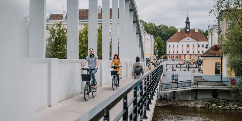
Thus, the new comprehensive plan, which will soon be open to public discussion, envisages a green area along most of the length of the former railway area, with intra-quarter streets planned for only a few sections within residential areas. The plan includes transforming part of the railway corridor into a linear park, with the rest being left mainly as a green area extending all the way to the Emajõgi River. A cycle track is planned for the entire length of the port railway, which extends from the city’s arterial road – from Riga Street to the recreation areas along the Emajõgi River.
As a city, Tartu is friendly towards cycle and pedestrian track users, with people here loving to walk and ride bicycles. In recent years, travel by bicycle has also been greatly boosted by the opening of Tartu’s Smart Bike Share system. Thus, for many Tartu residents, the addition of a new cycle and pedestrian track in the former port railway area is very welcome.
The attractive green area passing through the city, in the form of a linear park and an excellent cycle and pedestrian track opportunity, is sure to find plenty of use and will become a popular place to spend time among Tartu’s residents. Hopefully, this will also become an area of interest for tourists coming to the city as is the case with the High Line â – a 2.33-kilometre former railway area built in a park, which is visited by an average of five million people a year – located in Manhattan, New York.