5 minute read
Geologic Mapping in Iowa: Addressing Societal Problems

from IGS Geode 2020

Geologic Mapping in Iowa
Addressing Societal Problems with Maps
Advertisement
By Stephanie Tassier-Surine and Ryan Clark
Addressing Societal Problems with Maps
GEOLOGIC MAPPING has been a fundamental activity of the Iowa Geological Survey (IGS) since its inception. A geologic map is a tool designed to inform users about what lies on or below the land surface. Maps can incorporate a wide range of information, including the organization of geologic units (stratigraphy), the distribution and thickness of units, lithologic characteristics (rock type, fossils, structures), horizontal and vertical variability, and correlation of units over large areas.
The earliest geologic studies in Iowa focused on resource potential (limestone aggregate, coal, minerals). The first geologic investigation of Iowa began in 1839 when David Dale Owen was commissioned to conduct a survey of Iowa, Wisconsin, and Minnesota. This work culminated with the first geologic map of Iowa in 1852. Most early IGS publications, particularly the county reviews in the Annual Reports, used maps to disseminate geologic information.
IGS geologists use numerous resources when creating a geologic map. The IGS GeoSam database is an online catalog of over 90,000 drilling records. Although most records are paper drilling logs, about 40,000 also include drill cutting samples. More than 23,000 of those have been studied by geologists creating strip logs (a graphic illustration of the geologic materials encountered). The IGS core repository also houses 1,300 rock cores totaling 150,000 feet. When possible, the IGS also collects additional core, visits outcrop and quarry sites, collects laboratory data, and employs geophysical methods to improve our understanding of the geologic units and their relationships in a given area.
The IGS has participated in the U.S. Geological Survey’s (USGS) STATEMAP

GEOLOGIC MAPS EVOLVE over time, not only because of advancements in mapping techniques, but also through dedicated research. Since the late 1800s, the IGS has produced maps of various scales to communicate the complexities of Iowa’s bedrock and surficial geology. Each map reflects the improved understanding gained since the previous edition.
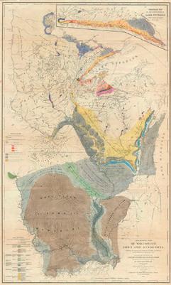

BEDROCK GEOLOGIC MAPS published by the Iowa Geological Survey in 1894, 1922, and 1969 (top to bottom). The progression of the maps illustrates the increased understanding of the bedrock geology of Iowa though time, as well as improvements due to an increase in available data at the time of their production.


program since 1993. The USGS awards funding to state surveys under a competitive grant program with a 50:50 match requirement. The state surveys choose projects in consultation with an advisory committee of public and private stakeholders, with preference given to areas that have both societal and scientific merit. Under this program, the IGS has received over $3.7M in federal grant funding and produced more than 150 geologic maps, including both surficial and bedrock maps at quadrangle (1:24,000) and county (1:100,000) scales.
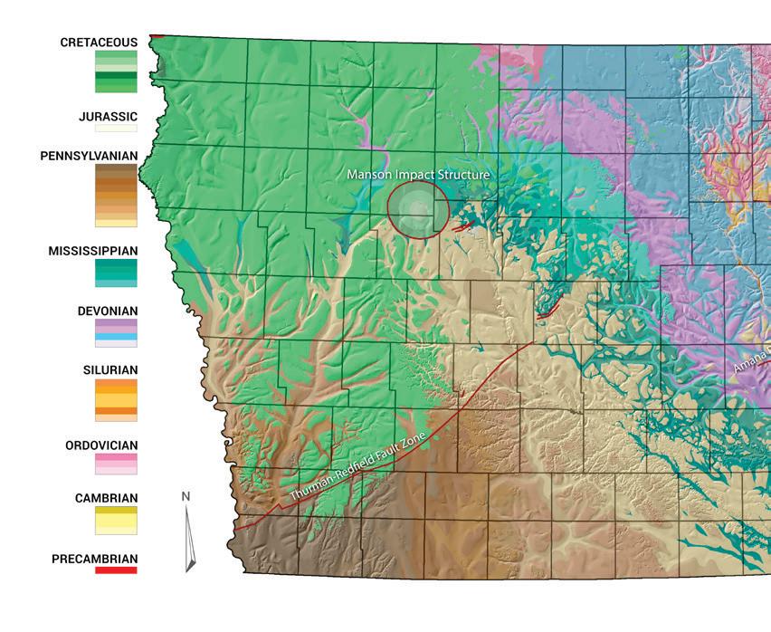
Work completed under the STATEMAP program also led to the current Bedrock Geologic Map of Iowa (Witzke et al., 2010). This map was a significant improvement over the previous version published in 1969 and was the first to be constructed using geographic information system (GIS) technology. Our geologic maps have been used by local, county, and state officials, as well as private entities, to address questions related to groundwater vulnerability, aggregate resources (both protection and sourcing), urban expansion, hazard potential, and land use planning. The IGS also produces derivative maps, in which geologists can combine many data sources to produce a map that directly addresses a particular need. A recent project funded by the Iowa Department of Transportation (IDOT) Highway Research Board was designed to identify the locations of sinkholes and other features related to karst geology in Worth, Cerro Gordo, Mitchell, and Floyd counties in north-central Iowa. Although sinkholes are often identified during county soil surveys, our initial assessment more than doubled the number of mapped depressions in the four-county area. This work will significantly increase our understanding of where sinkholes occur and result in maps that will inform the IDOT of where sinkholes may occur in the future. A karst susceptibility map will allow the IDOT to make informed decisions when planning future transportation projects, thus ensuring the long-term viability of vital roadways.
If the IGS had not already constructed detailed maps of the surficial and bedrock geology of the four-county area as part of the STATEMAP program, this endeavor would not have been possible. This project illustrates why geologic mapping is vital to our efforts to solve societal issues. Identifying geologic hazards through various mapping techniques has the potential to save money on avoidable infrastructure repairs and improve the safety of Iowa’s roadways.
Geologic maps often have many unanticipated uses. In 2011, a bedrock geologic map of the Upper Iowa River Watershed (UIRW) was completed in a combined effort between the STATEMAP program and the Iowa 319 Nonpoint Source Pollution Program. The original intent was to assess the degree to which surface contaminants affect bedrock aquifers and surface water bodies. However, a new hazard became apparent years later — flooding. Addressing the results of heavy rainfall events in a dynamic watershed required extensive knowledge of the subsurface. The UIRW Management Authority had selected best management practices, such as retention basins, to slow the flow of surface water runoff. Installing stormwater retention structures in areas of karst geology proved to be tricky and, once again, the detailed geologic map of the UIRW proved useful to guide where these vital structures would work best.
The UIRW geologic map and its associated mountain of data helped solve yet another societal issue in northeastern Iowa — frack sand mining. As the practice of hydraulic fracturing (fracking) of shale deposits in oil fields across the United States ramped up, the need for specific sandstone deposits increased dramatically. The St. Peter Formation is an ideal source for frack sand in the upper Midwest and it occurs near the land surface within the UIRW. The Winneshiek County Board of Supervisors consulted with the IGS numerous times about the effects of mining the St. Peter Formation in their area. Luckily, the UIRW geologic map had all the information they needed to make informed decisions to regulate this emerging industry.


