2 minute read
Appendix

from Irvine at 50: A Tale of Continuity and Change
by University of California, Irvine - School of Social Ecology

University of California, Irvine, School of Social Ecology Irvine at 50: A Tale of Continuity and Change • November 1 2021
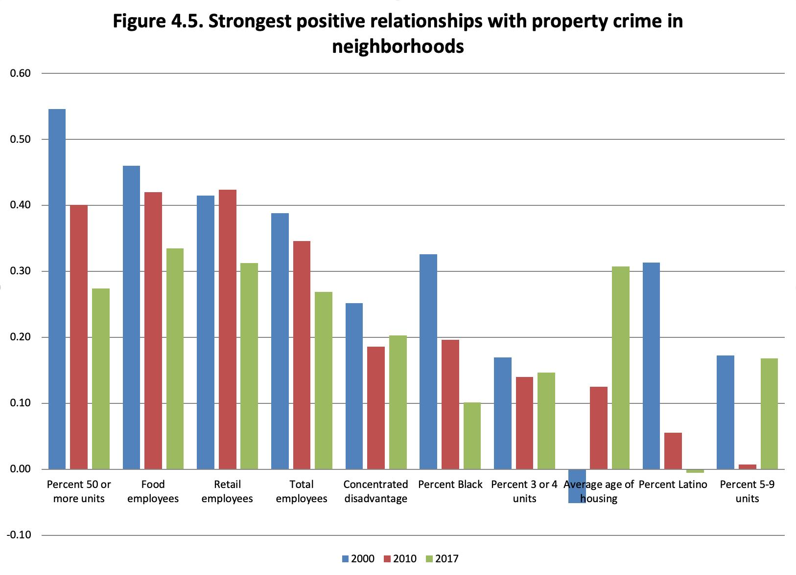
A number of data sources were used to compile this Report. The city-level crime data was obtained from the FBI’s Uniform Crime Reporting (UCR) program data, which provides crime data for all cities that reported their information to the FBI. We used the Part 1 crimes: violent crime was aggregated from homicides, robberies, and aggravated assaults. Property crime was aggregated from burglaries, motor vehicle thefts, and larcenies. City crime rates were calculated by dividing by the population, and then multiplying by 10,000 to express the rates per 10,000 residents.
» The police staffing data come from the FBI’s Law Enforcement Officers Killed and Assaulted (LEOKA) dataset, which also provides information on police staffing levels.
» We used city-level demographic data from the U.S. Census (for 1980, 1990, and 2000) and American Community Survey 5-year estimates data for 2010 (using the 2008-2012 5-year estimates) and 2017 (using the 2015-2019 5-year estimates).
» For 1970 for Irvine, the city was not yet incorporated. Therefore, in that year we used census tract-level data for that decade and aggregated the information in the tracts that were within the boundaries of the eventual city to compute the measures of interest.
» For the city-level regression models, the crime data is based on three-year averages centered on the year of the model. This smooths year to year fluctuations.
» For the computations on the number of cul-de-sacs and intersections in Irvine, we constructed a street network for the entire
Southern California region. We then computed the values of interest based on the street network within Irvine, and compared this to the values for the entire region.
For the computations of the clustering of businesses and jobs, we used the Reference USA Historical Business dataset. These are proprietary data with information on the locations of all businesses in the region for each year between 1997 and 2014. The businesses were geocoded to a specific location, and then aggregated to the appropriate census block. The data also provide information on the number of employees in each business.
School of Social Ecology
Science Driving Solutions
The School of Social Ecology is dedicated to interdisciplinary, problem-driven scholarship, teaching, and outreach in the public’s interest. Social Ecology’s unique focus and expertise has made it a national leader in applying basic theory and empirical research to address complex societal problems. Since 1970, Social Ecology has grown from a few dozen students to more than 2,500, with over 20,000 graduates working in fields as diverse as health care, human services, planning, education, law and public policy. The School is home to three highly ranked departments — Criminology, Law and Society; Urban Planning and Public Policy; and Psychology Science — that share a commitment to research that understands human behavior in larger social and institutional contexts, moves beyond traditional disciplinary boundaries, and reaches a diverse and broad audience.
UCI School of Social Ecology 5300 Social & Behavioral Sciences Gateway, Irvine, CA 92697 www.socialecology.uci.edu · secomm@uci.edu