RIVERVIEW OUTLINE PLAN
APRIL 2026
Prepared By: Prepared For:


Town of Rocky Mountain House

APRIL 2026
Prepared By: Prepared For:
Town of Rocky Mountain House
Adopted by Council Resolution on June 21, 2005
Amended by Council Resolution on DATE
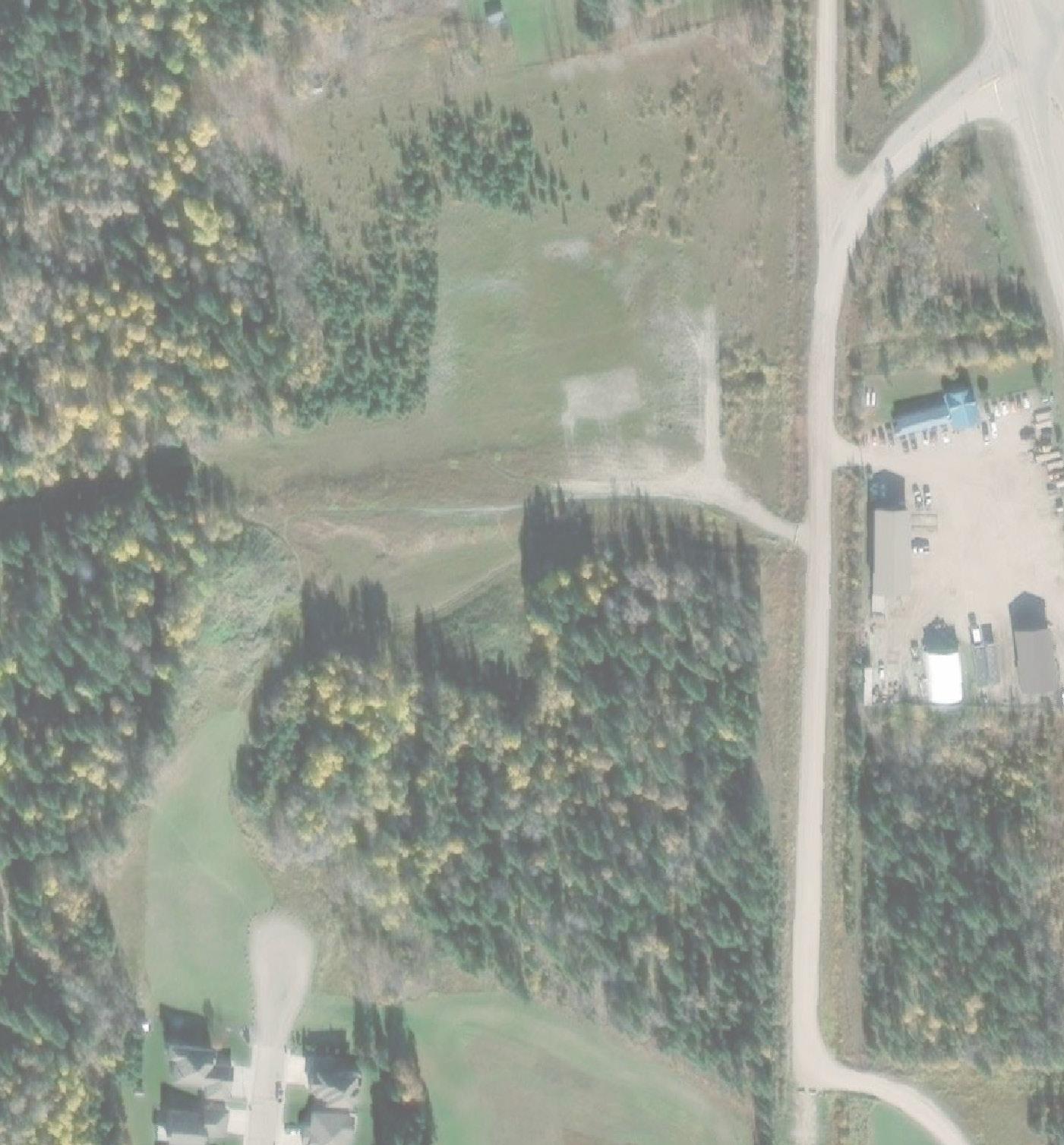
The Riverview Outline Plan area is located in the north end of the Town of Rocky Mountain House as shown in Figure 1. It is bounded by Highway 11 to the east, the Town boundary to the north, the North Saskatchewan River to the west, and existing development to the south. The Plan Area contains a total of 43.6 hectares comprising 42.34 hectares (104.6 acres) of titled land and 1.26 hectares (3.1 acres) represented by the road right-of-way for 60 Street and the intersection of 60 Street and Highway 11.
The Town is the largest single property owner in the Plan Area owning 30.7 hectares, which forms the core of the developable area. Three other properties owned by private landowners are located around the east and north perimeter of the Plan Area. A 5.96 hectare (14.72 acres) parcel is located between 60 Street and Highway 11, a 1.05 hectare (2.6 acres) parcel is located further north, and a 4.63 hectare (11.44 acres) is located in the northeast corner of the Plan Area. The location, boundaries and parcel sizes of each property making up the Plan Area are shown in Figure 2
Originally the Town acquired land in this area as part of the Town’s residential land banking activities. The impetus behind preparing an outline plan is to position the Town to be able to bring on residential lots over the next several years in response to demand in the local housing market.
The purpose of the Riverview Outline Plan is to provide guidance on the future subdivision and development of the Plan Area in a manner that is consistent with the Town’s statutory plans, Land Use Bylaw, master plans, and other policies affecting the development of property. It sets the parameters for more detailed plans of subdivision. By planning the area as a whole, the outline plan facilitates an understanding of the implications for each landowner and the municipality as subdivision proceeds in this area.
An update to the Riverview Outline Plan was prepared in April 2026 in order to respond to an updated policy framework and changes to market conditions, which have evolved since the outline plan was initially adopted.
Statutory plan guidance on the development of the Riverview Outline Plan area is provided through the Town’s Municipal Development Plan and the North Area Structure Plan. The Town’s Land Use Bylaw provides more specific direction on the development of individual lots for varying land uses. Other plans, such as the Recreation Master Plan and the Utility Master Plan, provide additional guidance. Some of the policies of these existing plans may require amendment to enable to the outline plan development concept to proceed. These policies are identified and discussed in Section 8.



The MDP identifies the majority of the plan area as “neighborhood residential” on the Land Use Concept Map. This broad land use category contains urban residential forms ranging from low density single detached housing to multiple family, apartment type housing. Two sites are identified as “Highway Commercial,” one in the south east corner of the Plan Area where 71 Avenue intersects Highway 11, and another along the east boundary of the Plan Area just south of the intersection of 60 Street and Highway 11. The precise nature of commercial activities allowed is subject to more detailed policies laid out in applicable area structure plans and outline plans (as is done in this plan). Finally, a large portion of the plan area is identified as “Open Space,” reflecting the presence of the escarpment leading down to the North Saskatchewan River and the River Flats area located below the escarpment.
Access to the area is shown conceptually via the intersection of 60 Street and Highway 11 in the north area, off 71 Avenue along the southeast corner of the Plan Area, and through the extension of 70 Avenue/61 Street.
Specific MDP policies that directly influence the development concept and policies for the area include:
• 5.6.3 n) “The Town shall require that at least 10 percent of the gross developable land being subdivided, less the land required to be dedicated as environmental reserve or environmental reserve easement, be dedicated as Reserve (municipal reserve, school reserve, or municipal and school reserve) in accordance with the provisions of the Municipal Government Act.”5.6.2 j) “Parks and open space shall be designed to create opportunities for area residents to gather and interact with seating, picnic facilities, and other elements that encourage socialization and community building.”
• 4.4.2 c)“The Town shall require that any subdivision proposal adjacent to a water body or water course dedicate a buffer from the water body/ course as environmental reserve to protect riparian areas and provide public access. The width of the required dedication shall be established by the Subdivision Authority.”
• 4.4.1 d) “Proposals for new communities must demonstrate adherence to environmental design principles identified within the Sustainable Community Design Guidelines.”
• 5.6.2 a) “As new areas are planned and developed, the Town shall ensure the provision of high-quality open space and linkages to existing and planned pathways and trails.”5.4.2 c) “Where necessary, adequate buffering between highway commercial and adjacent residential areas shall be provided to minimize noise, traffic, light, and visual impacts.”
• 5.2.1 d)“Residential development should be contiguous with existing developed areas in the Town to minimize servicing and infrastructure costs.”
• 5.2.1 f)“The Town will ensure that all residential development contributes positively to the public realm and the social connectedness of neighbourhoods through high quality, barrierfree, pedestrian friendly design.”
• 5.2.1 h)The Town will ensure that complete community design principles are incorporated in area structure plans, area redevelopment plans, outline plans, and plans of subdivision, including: i. designation of local commercial nodes, which include a mix of neighbourhoodscale commercial and public services that are easily accessed by residents and can be connected to transit in the future; ii. provision of complete streets which prioritize active modes connectivity;
iii. a fine grained, well connected network of local streets; iv. iv. a diversity of housing types;
v. v. high quality parks and open space and protection of natural assets; vi. designated areas for schools or other necessary public services determined by the Town, in liaison with education authorities; vii. vii. consideration for and preservation of heritage; and viii. viii. high quality building and site design.
• 5.2.1 k) “New manufactured home parks may only be located in specific areas identified within an area structure plan.” 5.2.2 a) “The residential density for new neighbourhoods is encouraged to be at least 20 dwelling units per gross developable hectare and shall not be less than 12.5 dwelling units per gross developable hectare.”
• 5.2.2 b) “Medium to high density multi-family housing shall be encouraged in Neighbourhood Residential areas, particularly in locations adjacent to or near collector and/or arterial roads and adjacent to local commercial nodes.”5.2.1 j) “The Town will encourage the strategic locating of seniors’ housing and care within walking distance of shops, services, and amenities.”
• 5.2.1 g) “The Town will encourage the provision of a mix of residential unit types within developments, including but not limited to large family units, single bedroom units, and barrier free units.”” 4.4.1h) “ Significant mature trees shall be retained wherever possible and replaced if removal is necessary for development.”.
The North Area Structure Plan identifies the Plan Area as predominantly residential land use with two commercial sites, a local park and major open space along the escarpment. The residential land use shown on the plan concept does not identify specific types of housing or areas for specific types of housing. Residential use is directed to the area above the top of the escarpment while the slope and lands below the slope are identified as environmental reserve open space. A neighbourhood commercial site is shown conceptually in the south east portion of the area close to the intersection of 71 Avenue and Highway 11. A highway commercial site is shown south of the intersection of 60 Street and Highway 11. A relatively centrally located open space area is identified to the west of 60 Street with trail corridor links to the escarpment area and the neighbourhood commercial site.
The majority of 60 Street north of 71 Avenue is identified for closure, which would make this land available for development. However, the MDP identified the retention of 60 Street, which is retained in the land use concept of this outline plan. Access points into the Plan Area are identified as the existing intersection of 60 Street and Highway 11, a northward extension of 70 Avenue/61 Street, and a new collector road extending north from 71 Avenue to the west of the intersection with Highway 11. Direct access onto Highway 11 in any new location is not permitted.
Specific ASP policies that directly influence the development concept for the area include:
• Preservation of the escarpment in its natural state except for the development of a trail system and dedication of the escarpment as environmental reserve.
• Dedication of a municipal reserve strip along the top of the escarpment to facilitate trail construction.
• Housing that is predominantly single detached.
• Limited areas of row, duplex and apartment housing at Council’s discretion where it considers road and open space accessibility to be adequate, the impact on adjacent uses to be acceptable, and the design sufficiently high and comprehensive to justify the higher density.
• Municipal reserves in generally central locations and linked by walkways to the trail system.
• Housing lots to be buffered from Highway 11 and commercial areas.
• Excluding utility trunk lines and gas pipeline rights-of-way from private lots.
• Housing lots adjacent to natural resource pipelines shall be sufficient in size so that structures are not built within 5m of the edge of the right-of-way.
• Land use designations and subdivision design to produce an average of 20 dwelling units per gross hectare.
• Use of 18m wide local roads throughout the plan area and minimal use of fourway intersections.
The Land Use Bylaw identifies the majority of the Plan Area as “Future Development (FD).” This zone is intended to restrict subdivision and development of the property to existing uses and limit the intensity of development until urban development that reflects the Town’s statutory plans is more imminent. A portion of the Plan Area is zoned “Low Density Residential District(RL),” which reflects the existing Stage 1 development. This zone allows the development of larger lots intended for detached dwellings.
Two sites zoned “Highway Commercial (HC)” are located along the west side of Highway 11 between the 60 Street and 71 Avenue Intersections. This reflects the direction of the Town’s MDP The ability for future lots to satisfy the Land Use Bylaw provisions relating to development near slopes will need to be addressed through the outline plan.
The Town’s Open Space Plan guides the use and expansion of the open spaces in the Town and the linkages between those spaces. It provides direction for the extension of the Town trail system through the plan area along the escarpment. The River Flats area, the area below the escarpment and along the river, is identified as a priority area for sports field/ball diamond development. The relative priority and timing of this development may have changed given the current focus on the North Saskatchewan River Park. However, there remains a long term need for sport fields in this area to keep up with future Town growth and increasing usage. A playground is identified for future development in the south central portion of the outline plan area.
In addition to the Open Space Plan, a more detailed series of options for the development of the River Flats area has been prepared by the Town. These options also address the means of providing physical access to the River Flats area thereby making it accessible to users, maintenance and emergency vehicles.
The proposed development of the Plan Area is influenced by the physical characteristics of the site, surrounding existing and future land uses, and the opportunities for the site within the context of the overall development of the community. The key significant features in and around the Plan Area and factors that influence the future development concept are graphically represented on Figure 2 and discussed in more detail below.
The Plan Area is shown on Figure 1 and is generally rectangular in shape. It is bounded by Highway 11 on the east, the Town boundary on the north, the North Saskatchewan River on the west, and the edge of existing development on the south. The development to the south is the first portion of the Riverview area that was subdivided in the early 1990s. The majority of the Plan Area is presently undeveloped. Existing development consists of:
• A storm water pond located in the south central portion of the area on the Town property;
• A country residential parcel containing a dwelling and several accessory buildings in the north;
• Industrial shops, offices and outdoor storage relating to oilfield services east of 60 Street; and
• Walking trails, look outs along the length of the escarpment and picnic facilities within the River Flats area.
An escarpment with an approximate height of 26m runs through the Plan Area in a northsouth direction. The top of bank elevation is approximately the 976m contour while the top of the bank has an elevation of 950m along the east shoreline of the North Saskatchewan River. The height of the escarpment decreases to approximately 20m at the north end of the Plan Area, with the river also curving westward away from the toe of the escarpment. The escarpment creates three distinct land form areas: the escarpment itself, the table land above the escarpment, and the flats area below the escarpment and east of the river.
The high point of land for the table land is located in the south east corner of the Plan Area at an elevation of approximately 982m. The low point for the table land has an elevation of approximately 976m and is located at the north end of the Plan Area. Generally, the table land above the escarpment is relatively flat and slopes from southeast to northwest.
The River Flats area is fairly level with elevations of 955m near the bottom of the escarpment and 950m near the river. A portion of the River Flats area is impacted by the 1:100 year floodplain of the North Saskatchewan River. This area is located in the very north east portion of the Plan Area
The entire length of the escarpment through the Plan Area is heavily treed with a mixture of deciduous and coniferous species. The areas along both sides of 60 Street are also heavily treed. In the area east of the escarpment and generally northwest of the storm pond there is an area containing numerous smaller size deciduous and coniferous trees. The area of the storm pond has been stripped of topsoil and there exists a clay stockpile and a topsoil stockpile.
Select portions of the Plan Area offer views of the Rocky Mountains off to the west. Given the heavily treed character of the escarpment, there are limited views of the North Saskatchewan River from the table land. Proximity to the North Saskatchewan River valley and associated trail system makes this an attractive area for residential development.
Surrounding uses of the subject site include low density urban residential to the south, agricultural use to the east, northeast and north, the Town’s sewage lagoon to the southeast, some country residential acreages to the immediate north, and country residential to the west across the river. The developed and future land uses immediately around the subject site pose no significant land use incompatibilities that cannot be managed through the design of the area.
The existing industrial and commercial uses within the Plan Area will have a significant bearing on the design of the area and the overall phasing of development. The existing industrial uses consists of the storage of large volumes of chemicals and solutions (flammable and non-flammable liquids, propane, diesel fuel, corrosion inhibitors) used by the oilfield industry. There is no legislated separation distance between residential development and this type of use. Over the long-term, the MDP and the North ASP identify the area north of the Plan Area as predominantly residential. It is expected that this industrial use will eventually relocate and in the interim expansion of the industrial operation should be limited through the Land Use Bylaw. While the presence of this industrial use does not prevent residential development in the Plan Area, uses that are more difficult to evacuate (i.e. places of public assembly) should be directed elsewhere. Ongoing access to the industrial development that separates residential and truck traffic as much as possible will have to be taken into account as each phase of development proceeds.
Similar to the above discussion, the existing commercial use’s access will need to be maintained keeping truck and residential traffic separate for as long as practical. Over time, the present commercial use may be replaced with a more commercial oriented use catering to passing motorists on Highway 11.
Highway 11 and the Town’s sewage lagoons are two land uses in the vicinity that impact on the subject site and each is further discussed below.
Highway 11 is located along the east boundary of the Plan Area. At the south end of the Riverview, the elevation of the Highway traffic lanes is higher than the land within the Plan Area by approximately 2m. In the north portion of the Riverview, the Highway traffic lanes are approximately equal to the elevation of the land in the Plan Area. Just before the north boundary of the Plan Area, the Highway traffic lanes begin to decrease in elevation to go down the escarpment and across the North Saskatchewan River. The Highway poses a potential constraint on the development of the area for residential purposes in the form of traffic generated noise that may exceed tolerable levels.
A noise analysis report was not prepared for the plan area based on the experience with
the LeCerf area. The noise analysis report in that case, where a similar set of circumstances were faced, required no mitigation or attenuation measures. Instead, the plan makes provisions for noise attenuation measures either immediately upon initial subdivision or at a later future date.
As mentioned above, the Town’s sewage lagoon is situated to the southeast of the Plan Area. Provincial regulation requires that all residential development and some forms of non-residential development must maintain a minimum setback distance of 300m from the operating area of a facility of this nature. The required setback distance includes the southeast corner of the southern commercial site; however, a conditional relaxation of this requirement, to a distance of 130m for the land west of Highway 11, has been provided by Alberta Environment. The conditions of the relaxation are as follows: 1) the Town must consider the need for future expansion of the wastewater treatment facility and provide allowance in subdivision planning, and 2) the new subdivision owners within 300m of the wastewater treatment facility should be well informed that their property is within the original 300m setback distance. A restrictive covenant will be registered against the title of the all new lots created within the original 300m setback distance to notify prospective purchasers of the presence of the sewage lagoon. In addition, the visual impact of the sewage lagoon must be addressed through adequate visual screening from as much of the plan area as possible.
Direct vehicle access to the Plan Area is restricted to three points: extension of 61 Street, an extension of 60 Street, and the existing connection to Highway 11 opposite the intersection of Highway 22. Other than the intersection of Highway 11 and Highway 22, no direct access to Highway 11 is permitted. Additional road widening for Highway 11 is not required.
In total, five utility rights-of-way (URW) and easements are present within the Plan Area. The most significant is the right-of-way formed by Plan 4326 MC and Plan 4526 MC (shown on Figure 2). This oil pipeline right-of-way bisects the Plan Area from east to west splitting the residential area in two so that approximately one third is north of the pipeline and approximately two thirds are south of the pipeline. A smaller right-of-way approximately 3m wide parallels and abuts the south boundary of Plan 4526 MC as part of the rural natural gas system. Within the southern commercial site, approximately 285m north of the south property line and next to 60 Street there is a 5m by 10m easement area for a facility owned by TransAlta. A similar TransAlta easement applies to a 10m by 10m area on the Town’s land west of 60 Street and 375m north of the south quarter line. Finally, the northern commercial site contains an easement for the Rocky Gas Co-op with no specific easement area defined. Some of these rights-of-way and easements will be incorporated into the design for the plan area while other facilities may be removed or relocated as part of the development process.
Two deferred reserve caveats are registered against lands within the Plan Area. The first
applies to the Town’s land and accounts for 3.10 hectares (7.66 acres) representing 10 percent of the total land in title. The second applies to the south commercial land for 0.59 hectares (1.47 acres) representing 10 percent of the land in title.
Two separate geotechnical investigations have been prepared for the Plan Area. The more detailed investigation covers the most southerly portion of the Plan Area between the existing storm pond and the escarpment. The more preliminary investigation covers the remaining portion of the Plan Area extending north along the escarpment. Both investigations have been submitted to the Town under separate cover. Given the preliminary nature of the geotechnical investigation for the northern portions of the plan area, a confirmatory drilling program is recommended for some areas prior to any development taking place.
One purpose of the detailed investigation was to determine the nature and properties of the soil and their potential implications for the installation of underground services, road sub-grades and foundation systems. Another purpose was to assess the issue of slope stability and provide recommendations to mitigate future risks of slope failure. Key findings of the investigation include the following:
• The soil profile generally consists of a thin layer of topsoil, surficial silty clay and/or sand overlying bedrock and silty clay with bedrock encountered at a depth of 11 to 14m below grade.
• The local groundwater table is expected to range seasonally between 4 and 7.4m below grade.
• Foundation conditions are considered to be suitable for residential structures using standard house basement foundations. Road sub-grade conditions vary from poor to good.
• The stability of the slope may be negatively impacted by toe erosion, increases in surface moisture content and loss of vegetative cover. Development restrictions must be implemented to protect the slope from destabilizing activities (i.e. keep the crest area natural).
The investigation outlines the site preparation, design and foundation techniques recommended to ensure proper development within the Plan Area.
Specific recommendations from the two investigations relating to slope stability and the nature of development near the slope are as follows:
• No permanent development should be allowed on the upper slope area which is defined as treed land or areas below the 978m contour for the area west of the existing storm pond (shown on Figure 2) and defined as the treed land or areas below the 976m contour for the area north of the existing storm pond (shown on Figure 2). The upper slope area is to be kept as a development buffer or setback. Temporary structures such as patios and sheds are allowable.
• No fill should be placed on the original slope below the 978m contour for the area west of the existing storm pond.
• No fill should be placed on the original slope below the 978m contour for the
area north of the existing storm pond until a confirmatory drilling program and more site specific geotechnical investigation has been undertaken.
• Lots should not extend into the present tree line and a 2-3m wide buffer is suggested between the tree line and rear property lines.
• Backyard fills above an elevation of 978m should be less than 0.5m. Front yard fills should be less than 2.4m unless approved by a geotechnical engineer.
• Site grading must direct drainage from rainfall and snowmelt away from the slope. All roof leaders and weeping tile must be directed away from the slope. Water should not be discharged uncontrolled down the slope or allowed to pond near the slope.
• Excessive watering of lawns is to be avoided and no permanent lawn sprinklers, ponds or swimming pools should be permitted within 50m of the crest without site specific geotechnical review.
• Existing vegetation should be retained. New vegetation should be selected from native types with deep root systems and requiring minimal watering.
• Fill, grass cuttings or debris of any sort should not be disposed of on the upper slope area.
The Plan Area can be fully serviced with municipal water, sanitary sewer, and storm water drainage systems through extensions from existing subdivisions to the south and west of Riverview. Shallow utilities (cable, telephone, electricity, natural gas) are also available at the edge of the Plan Area.
At one point, the Plan Area was considered to have a good likelihood of containing sites of historical and archeological interest due largely to its proximity to the North Saskatchewan River. As part of the process of approving the first portion of the Riverview subdivision (immediately south of the plan area) in the early 1990s, an historical resources impact assessment was completed. This assessment included all of the lands within the Plan Area lying west of the 60 Street right-of-way.
Key observations from the assessment included the discovery of two sites of potential interest. The first site was a scattering of prehistoric Native cultural materials (e.g. rock scrapper) near the soil surface. The second site was evidence of the historic trail between the Rocky Mountain House and Edmonton House trading posts dating back to the very early 1800s. Both of these sites have been heavily disturbed by agricultural and development activities. The assessment recommended that neither site warranted preservation or further archeological investigation. Recording the presence of these two sites and documenting information about them was considered sufficient. Alberta Community Development, Cultural Facilities and Historical Resources accepted the assessment’s conclusions and recommendations. The two sites are considered to have been sufficiently mitigated prior to further impact by development. No further consultation with Alberta Community Development or investigation into historical resources within the Plan Area is required.
In accordance with the MDP and ASP, with amendments where necessary, the subject lands are allocated for residential, commercial, and open space uses as shown on Figure 3.
Residential land uses focus on low density residential forms of development. Commercial land uses comprise of two highway commercial areas. The highway commercial sites are in line with the MDP and the existing designated highway commercial sites
The open space system is intended to serve the needs of the future residents of the Plan Area, as well as provide open space areas for residents in neighbouring subdivisions. The largest portion of the open space system is the escarpment area along the North Saskatchewan River and the River Flats area that is below the escarpment. Connections to existing and future trails are accommodated in the open space system to provide linkages from the Plan Area to other parts of the community such as the trail system along the North Saskatchewan River.
Most of the residential area will be accessed through a system of local roads connecting to 71 Avenue, 60 Street, 61 Street, and Highway 11. Sufficient right-of-way has been included to build sections of collector road if needed. Commercial related traffic has been kept to the edges of the plan area to avoid routing through the residential areas.
The table below provides a more detailed breakdown of the area devoted to individual land uses and the anticipated number of residential lots .
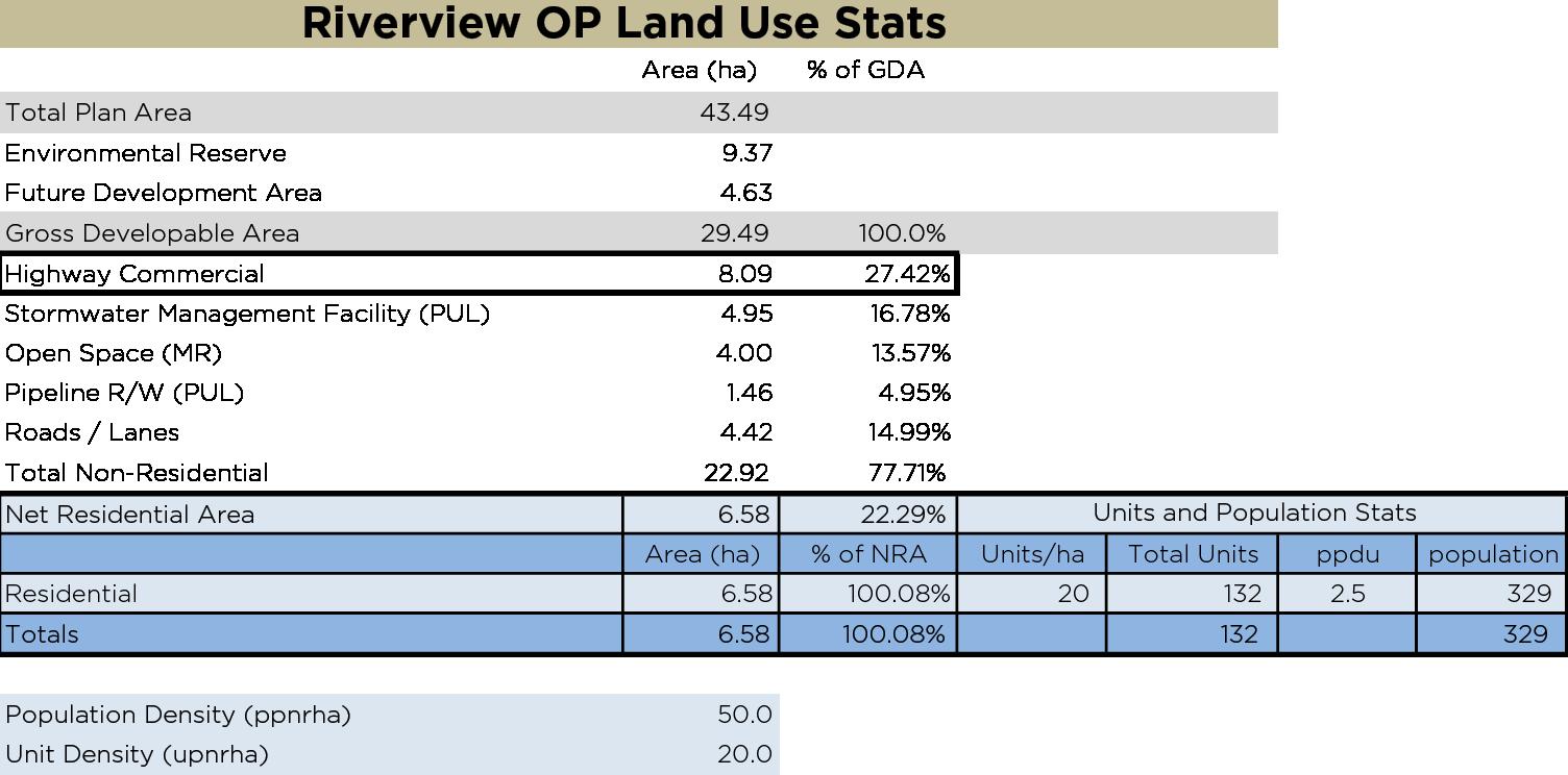
The low density residential areas shown on Figure 3 are intended to provide lots for detached and attached dwellings.
Prior to development of the residential areas on Figure 3, Land Use Bylaw amendments will be required to select the appropriate residential designation. It is at this stage that the precise type of lots will be established.
While the development concept allows flexibility in the selection of low density forms of residential, is expected that the following guidelines will be followed when LUB amendments are brought forward and considered by Council:
• Larger and wider lots will be directed to the areas closer to the escarpment;
• More compact and narrower lots may be directed to the areas closer to 60 Street; and
• Lots that front onto and directly face one another on the same street or segment of street (as defined in the LUB) will have the same Land Use Bylaw designation.
Detailed lot dimensions will be established through the review of proposed plans of subdivision.
The development concept shows the top of the escarpment in a general sense based on the 978m contour (based on digital contours provided by the Town). Residential development backing onto the escarpment must take into account the issue of slope stability. To ensure that the recommendations of the slope stability analysis that has been conducted as part of this outline plan are followed and to ensure the creation of lots that are safe for residential use over the long term, the following actions shall be required:
1. Stripping, grading and placement of fill below the 978m contour line shall not
proceed until more detailed geotechnical investigation has been undertaken.
2. Land Use Bylaw amendments or re-designations that would allow further subdivision of the lands along the escarpment and north of the existing storm pond shall not be approved until the setback from the edge of the escarpment has been confirmed through additional detailed geotechnical investigation where required.
3. When lands along the escarpment are subdivided, a restrictive covenant shall be registered on the title of all new lots along the top of the escarpment. This restrictive covenant shall be based on the recommended development restrictions described above.
Some of the residential areas shown on Figure 3 may require more detailed slope stability assessment on a lot by lot basis at the time of subdivision or development permit approval.
Where residential lots do not have access to a rear lane, a shared access easement with the adjacent lot to allow vehicle access to the rear yards may be required. This is intended to make it possible to store recreation vehicles in the rear yard or behind the front edge of the main dwelling.
There is the potential for 132 lots for detached dwellings assuming a mix of these LUB designations is used. Overall the development density for the residential portion of the plan area may range from 20 units per net residential hectare.
At a rate of 2.5 persons per detached unit, a population of approximately 329 persons may be accommodated once the plan area is fully developed.
Opportunity for highway commercial development has been provided in two separate locations. The highway commercial area incorporates the two existing highway commercial sites. The type of commercial uses allowed is described in the Highway Commercial District of the Land Use Bylaw and may include such uses as restaurants and hotels. The sites are accessible off Highway 11 via 60 Street. Direct access off Highway 11 is not permitted.
Due to the presence of the escarpment overlooking the North Saskatchewan River, open space is the largest single land use within the Plan Area. The total amount of open space provided in the development concept far exceeds the maximum 10 percent MR dedication requirement. The bulk of the open space is the environmental reserve (ER) dedication represented by the escarpment itself. Other areas forming part of the open space system include the two storm ponds which are usually dedicated as public utility lots.
The River Flats Active Space shown on Figure 3 is land owned by the Town and purchased for recreational development. Access to this area is provided by a proposed seasonal access road that connects to the west end of the northern local road. Future development in this area may include soccer pitches, ball diamonds, trails, and picnic shelters.
A tot lot has been provided in the northern portion of the Plan Area to provide for the local playground needs of the area.
A system of trails is planned to extend through and around the Plan Area. Trails extending from the existing trail along the North Saskatchewan River can be connected to provide a loop around the existing storm pond. The oil pipeline right-of-way also offers the possibility of a trail connection to the existing trail along the river and would connect to the tot lot. The local sidewalk system will also provide for pedestrian circulation in the area.
Due to the close proximity of Highway 11, there may be a need to plan for the eventual construction of noise attenuation features. This may include a berm and/or fence in the long term. Landscaping may also be required to create a visual screening of Highway 11 from view of the residential areas.
Where open space areas abut a lane, post and cable fencing or some other effective barrier may be required to ensure that private vehicles can not access or drive over the open space area. Chain link fence will be provided along the property line of all residential lots facing or backing onto the escarpment area. This fence is intended to clearly mark the limits of private property and start of the environmental reserve area. When the lots are developed along the east side of 61 Street, the existing stand of trees between 61 Street” and the existing storm pond will be preserved to the greatest extent possible. This will include grading around the stand of trees to avoid damage to the root systems. As much of this tree stand shall be kept under public ownership as possible.
Each separately titled property will provide at least 10 percent municipal reserve dedication as required by the Town’s Municipal Development Plan and the Municipal Government Act. Cash-in-lieu dedication will only be considered where dedication of land is not possible.
Pipeline rights-of-way and storm ponds will not be considered part of the 10 percent municipal reserve dedication. These areas will be dedicated as public utility lots.
The development concept provides for three (3) accesses to the Plan Area using existing roadways. These access points allow for alternate routes into the residential area and to the commercial properties.
The road layout allows for internal vehicle circulation within the Plan Area. At the same time it is intended to direct traffic towards 71 Avenue, 60 Street, and Highway 11 to keep the traffic use of each access point relatively equal. Short-cutting is discouraged by avoiding long straight stretches of road through the Plan Area. Access is also maintained to the rural acreages to the north of the Plan Area.
All proposed roads within the Plan Area will be constructed to the Town’s Design Guidelines.
The seasonal access road to the River Flats Active Space will be designed so that the road can be closed off from vehicle use. This may include installation of bollards and a
traffic control gate.
A traffic impact assessment will be prepared for any subdivision that creates a connection to Highway 11. This assessment will review the need for and nature of improvements at the intersection of Highway 11 and 60 Street/Highway 22.
The servicing plans prepared for this outline plan have been developed using data available from the Town’s files for the water, sanitary sewer and storm sewer systems. The accuracy of this information must be confirmed prior to proceeding with detailed design. These servicing plans are intended as general guides for the future provision of utility services and alternative approaches may be considered and used without amending this outline plan. Any changes or deviations from the servicing plans are subject to Town approval and review of the impact on all landowners within the plan area. Municipal and shallow utilities serving the plan area will generally follow the road allowances. At some points, public utility lots (not shown on the Development Concept) may be used to provide for the utility alignments shown on the servicing concept drawings.
To accommodate underground utilities and to provide for proper drainage, the area will require grading. Over excavating of the north storm pond is required to obtain sufficient clean fill for all stages of development apart from Stage 1. There is sufficient stockpiled material on site to complete Stage 1.
Stripping, grading and placement of fill below the 978m contour line shall not proceed until more detailed geotechnical investigation and a confirmatory drilling program have been undertaken.
Where select stands of existing trees (see discussion in Section 4.3) are to be preserved, site grading and stripping activities will be limited so as to minimize the potential damage to the root system of the trees to be preserved.
In areas where fill to the final lot grade exceeds 1.2m, a bearing certificate for the house foundation will be required. Lots requiring a bearing certificate will be identified on the lot grading plan submitted to the Town for each stage of subdivision.
The storm water drainage system has been designed using the Town’s Design Guidelines. All flows in the minor system (pipes and catch basins) were calculated using the Rational Method for a one in five year rainfall event.
Figure 4 shows the proposed storm water collection system for the Plan Area. Due to the unknown depth of the existing oil pipeline, the system has been divided into two separate areas. The first area is all of the land south of the oil pipeline right-of-way, which drains into the existing storm pond. The second area is the land north of the oil pipeline right-ofway which drains into a new storm pond in the north east part of the Plan Area
The existing storm pond will have to be expanded to be able to accommodate run off from the lands north of the pond. The new storm pond to the north will be a dry pond (does not permanently hold water) that discharges through a storm water cleaning manhole (Stormceptor). The two ponds will manage the quantity and quality of water leaving the area, which eventually discharges into the North Saskatchewan River.
The general direction of flow for the major storm water system is shown in Figure 4. Development of the storm water management facilities will be staged as subdivision occurs in the Plan Area.
Figure 5 shows the proposed water system layout. The water system has not been modeled as the 300mm diameter main extending through the Plan Area together with the existing 250mm diameter main in 61 Street will be more than adequate to deliver the necessary water flows for the area. However, fire flow requirements and watermain sizes must be confirmed at detailed design stage.
The 300mm diameter main located in 71 Avenue will be extended along 60 Street. It will tie into the 200mm diameter main extended along 61 Street, and connect to the future local road on the northwest edge of the Plan Area This connection will provide a full internal loop to ensure an adequate water supply.
Figure 6 shows the proposed sanitary sewer collection system planned for the area. Apart from the residential lots along 61 Street and the highway commercial sites, most of the sanitary sewer for this area will flow to a new lift station proposed to be located south of the oil pipeline right-of-way. From this point, sanitary sewage would be pumped to the Lichak lift station located west of 60 Street between 69 Avenue and 70 Avenue. Sanitary sewage from the residential lots along 61 Street and the highway commercial sites flow directly to the Lichak lift station.
Calculations of capacity and flows from the Plan Area and adjacent areas that are served by the Lichak lift station indicate that some upgrades are required to the Lichak lift station to accommodate sanitary sewer from the plan area. This may include twinning the forcemain along 60 Street and upgrading the pumps. The exact nature of these upgrades will be determined at the detailed design stage.
Shallow services (telephone, cable, electricity, gas) will be developed in accordance with the requirements of the private utility provider. These services can be extended into the plan area from the developed areas to the south.
The staging of development will generally progress from the southeast and move north. This is due to the topography of the area and the need to extend existing services from the south of the Plan Area. This pattern is shown in Figure 7.
Stage 1 and Stage 2 can make use of existing gravity sewer lines while the remaining lands require the new lift station.
Stages 3 and 4 may proceed together or separately. If Stage 3 is developed on its own, an easement for the lift station, sewer line to the lift station and forcemain will be required, and looping of the water mains through Stages 2 before subdivision and development can commence. Also, development of Stages 3 and 4 will require the construction of the new storm pond in Stage 4 to have the necessary amount of clean fill available.
Amending the Land Use Bylaw designations of the Plan Area is generally the first required step in implementing the Riverview Outline Plan. The exception is the area already designated as “Low Density Residential” RL.
The remaining areas should be re-designated as development becomes imminent. For the lands along the escarpment, the application to amend the Land Use Bylaw should be accompanied by a more detailed assessment of slope stability.
At the time of subdivision, the top of the escarpment and the location of the 978m contour must be confirmed through field survey. This information must accompany any subdivision application for this area. A restrictive covenant relating to protection of slope stability over the long term will be a condition of subdivision approval for lots backing onto the escarpment.
Given the need to confirm the precise location of the top of the escarpment limits with survey information at the time of subdivision, the development concept shown in Figure 3 should be applied in a flexible manner. Minor changes are possible without formally amending the outline plan.
At the time of subdivision, a restrictive covenant will be placed on the title of all lots created within the 300m setback from the Town’s sewage lagoon as a means of notifying future landowners of the lagoon’s presence.
Finally, amendments to the Town’s Municipal Development Plan and the North Area Structure Plan are required as part of the process to adopt this outline plan. This is intended to maintain consistency between the Town’s various land use plans. These amendments include:
1. Amending the MDP policy requiring a 15m setback from the top of the bank along the river to either remove the requirement or define exceptional circumstances;
2. Amending the ASP policy requiring a 6m setback and trail along the top of the escarpment;
3. Amending the ASP policy relating to the width of road rights-of-way;
4. Amending the ASP policy relating to excluding gas rights-of-way from private property/lots;
5. Amending the ASP policy relating to the use of the closed portions of 60 Street for residential and open space purposes only; and
6. Amend the ASP policy relating to achieving an average density of 20 units per net residential hectare.