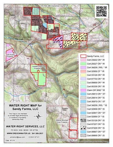
T2S R4E WM Clackamas County, OR
So uth
For k
Tic k
le C
re e
k
Main Farm Deep C re ek
Judd Road Property
Sandy Farms, LLC
Cert:23022 OR * IR Cert:29327 OR * IR
Howlett Road Property
Cert:34208 ( RR) * IR Cert:52956 CF * IR
Cert:53128 OR * IR Cert:67733 OR * IR Cert:89668 OR * IR Cert:85338 OR * IR C ose Go
Claim:GR 3892 * IR
k re e
Cert:29813 OR * ST Cert:29814 OR * IS
Cert:30870 CR * ST
WATER RIGHT MAP for Sandy Farms, LLC This map is not intended to provide legal dimensions or locations of property ownership lines.
.
Cert:34208 ( RR) * IS Cert:52858 OR * IS
Cert:52857 OR * ST Cert:52956 CF * IS
Cert:53128 OR * IS
Wildcat Mountain Drive Property
Cert:67227 OR * IS
WATER RIGHT SERVICES, LLC
Cert:67228 OR * IS
PO BOX 1830, BEND, OR 97709
Cert:89667 OR * ST
WWW.OREGONWATER.US 541-389-2837 CCB # 197121 Cr
k ee
Date: 4/1/19
Cert:89668 OR * IS
e gl Ea
johnshort@usa.com
T2S R4E WM Clackamas County, OR
Copyright:© 2013 National Geographic Society, i-cubed
April 4, 2019 Global Ventures, Inc. 4721 354th Ave. SE Fall City, WA 98024 Re: Water rights of Sandy Farms, LLC, Sandy, Oregon To Whom It May Concern: Please find attached our analysis of Sandy Farms, LLC’s current water right situation. Always glad to entertain questions. Hope this helps. Sincerely,
John A. Short
Water Right Services, LLC P.O. Box 1830 Bend, OR 97709
John A. Short CCB# 197121 541-389-2837
johnshort@usa.com www.oregonwater.us
Initial Spring Irrigation Water Rights Res # 3
! P From Res # 1
From Res # 3
So uth
Fo rk
Tic k
le C
Sandy Farms, Inc.
Cert 52956 Res # 1
Cert 34208 Well
Cert 85338 Res # 3
Well
Cert 89668 Res # 1
re e k
Cert 23022 Res # 2 Cert 53128 Res # 4
Res # 2 From Res # 1
From Res # 1 From Res # 2 Res # 1
From Res # 1
From Res # 1 From Res # 1 From Res # 1 From Res # 1 Well
P !
From Well
From Res # 4
Res # 4
.
Date: 4/1/19
WATER RIGHT MAP for De ep Cr ee Sandy Farms, LLC k Main Farm
WATER RIGHT SERVICES, LLC
PO BOX 1830, BEND, OR 97709 This map is not intended to provide legal dimensions WWW.OREGONWATER.US 541-389-2837 or locations of property johnshort@usa.com CCB # 197121 Source: USGS, EPA,lines. Source: Esri, DigitalGlobe, GeoEye, Earthstar Geographics, CNES/Airbus DS, USDA, USGS, AeroGRID, IGN, and the GIS User ownership Community
Water Right Abstract of Sandy Farms, LLC Prepared for Global Ventures, Inc. this April 4, 2019 Summary: Sandy Farms, LLC includes four locations of contiguous tax lots totaling 966.37 acres. All water rights authorize up to 2.5 AF/acre at up to 1/80th cfs/acre. Though this water right portfolio is in excellent administrative condition, actual water sources and priority dates likely restrict full season, full rate & duty irrigation. Sandy Farms’ 95 acre Wildcat Mountain Road property and about 40 acres of their Main Farm have farming activities without water rights. To quote a cheery phrase common around Oregon’s Water Resources Department (OWRD), “Nothing in water rights will ever be easier than it is today!” To that end, recent OWRD rule changes now require multiple agency approvals including from Oregon Department of Environmental Quality and Oregon Department of Fish & Wildlife, among others. Hence, applications for new groundwater rights recommended below may require forfeiture of existing surface and storage rights. Main Farm – 659.93 acres with about 480 acres multi-source water rights. Sources include a well, a spring fed large reservoir (Res # 1 expanded as # 1A), South Fork Tickle Creek (Res # 2 & # 3) & an unnamed tributary to Deep Creek (Res # 4). One neighbor shares rights to Res # 1. This portion of Sandy Farms lies both North and South of the Eagle Creek - Sandy Highway. It includes 14 individual certificated water rights from four separate, relatively weak sources. Water right maps indicate cross-highway piping allowing large Reservoir # 1 to act as both a legal irrigation system bulge for short term (7-day) storage and as a central pumping location for all Main Farm fields. Current water right coverage allows excellent flexibility, i.e. any given field can justifiably use water from any of the four reservoirs, either stream, or the well. All four reservoirs have one or more certificated storage rights. Small in-channel Reservoirs # 2, # 3, and # 4 provide little more than water collection for pumping. Storage rights for large Reservoir # 1 authorize up to 110 AF versus full duty for 2.5 AF over 480 acres taking 1,200 AF. Both South Fork Tickle Creek and the unnamed tributary to Deep Creek typically run strong early each irrigation season but rarely provide useable late season water. Deep Creek (including its tributary, Tickle Creek) are over-appropriated July through November so at least Sandy Farms’ more junior rights should typically be regulated off midseason. Senior Deep Creek Basin rights began in 1924 where Sandy Farms’ water right priorities range from 1950 to 1997. The spring feeding Reservoir # 1 contributes a small, unknown amount of water. Geology limits well strengths in the area. The Main Farm well may supply up to 250 gpm of the 2,700 gpm authorized by existing water rights.
Water Right Services, LLC P.O. Box 1830 Bend, OR 97709
John A. Short CCB# 197121 541-389-2837
johnshort@usa.com www.oregonwater.us
Roughly 40 acres near Sandy Farms’ main office appears farmed with no water rights. This may or may not be intentional. Sandy Reservoir (also called Reservoir 1, 1-A, John Rowell Reservoir, Dam ID OR00709, File S-83, & Sandy Farms Dam) in its cursory 2017 inspection had brush and a tree growing in the 30’ X 5’ spillway. Additionally, brush prevented inspection of its outlet. Dam currently rates as a Significant Hazard – a risk to private property but not loss of life. Main Farm Recommendations or Comments: Several actions look appropriate depending on an owner’s chosen strategy. They include: 1) Apply for additional groundwater rights if needed for roughly 40 acres of developed land near Sandy Farms’ main office. 2) Drill widely spaced, additional wells to 1,000’ - 2,000’ depths to pull water from the more permeable Columbia River Basalt layer to increase capacity towards the farm’s authorized limit of over 2,700 gpm. Expect 500’ static water levels. 3) Clear brush from Reservoir 1 spillway and reservoir outlet for flood safety. Judd Road Property – 46.07 acres with about 44 acres single source groundwater rights authorizing nearly 350 gpm from a well producing 100 gpm maximum. Judd Road Recommendations or Comments: 1) Drill replacement well 1,000’- 2,000’ deep seeking full authorized 350 gpm rate. 2) Develop roughly eight legal lots to sell separately as 5 +/- acre hobby farms if codes allow. Utilize boundary line adjustments to accomplish size changes and access. Howlett Road Property – 164.24 acres with 136.5 acres single source Deep Creek surface and storage water right. Howlett Road Recommendations or Comments: Apply for supplemental groundwater irrigation to strengthen or replace existing right if desired. Again, this requires drilling a 1,000’ – 2,000’ irrigation well. Wildcat Mountain Drive Property – 94.94 acres, no water rights. Wildcat Mountain Drive Recommendations or Comments: Apply for groundwater irrigation if desired. Similar to those above, this requires drilling a 1,000’ – 2,000’ irrigation well.
Water Right Services, LLC P.O. Box 1830 Bend, OR 97709
John A. Short CCB# 197121 541-389-2837
johnshort@usa.com www.oregonwater.us
Res # 3
24E21 TL 400 38.4 ac IR
24E21 TL 200 34.4 ac IR
Res # 2 24E22 TL 900 24.7 ac IR
24E21 TL 300 140.2 ac IR Res # 1
24E22 TL 2200 22 ac IR
South Fork Tickle Creek
24E22 TL 2300 51.2 ac IR
24E22 TL 2400 23.4 ac IR
37.8 ac IR
24E27 TL 100 47 ac IR
24E27 TL 200 24.4 ac IR
24E26 TL 700 5.7 ac IR Res # 4
ee D
24E29A TL 1600 44 ac IR
24E22 TL 2700 37.6 ac IR 24E23 TL 2300
p re C ek
24E33 TL 104 22.3 ac IR
24E28 TL 2900 1.2 ac IR
24E28 TL 2800 24E28 TL 2801 15 ac IR 37.8 ac IR
Go o
se
Cr ee
k
24E33 TL 102 58.7 ac IR
.
WATER RIGHT MAP for Sandy Farms, LLC
WATER RIGHT SERVICES, LLC PO Box 1830, Bend, OR 97709 OREGONWATER.US
541-389-2837
johnshort@usa.com
CCB # 197121 Date: 4/23/19
Sandy Farms, LLC
Cert 89668 Res # 1
This map is not intended to provide legal dimensions or locations of property ownership lines.
Cert 85338 Res # 3 Cert 53128 Res # 4 Ea
Cert 52956 Res # 1 gl e
ee Cr
Cert 34208 Well k
Cert 23022 Res # 2
Cert 29327 Deep Creek
34E03 TL 400 0 ac IR
Cert 67733 Well
Claim:GR 3892 Well
Source: USGS, EPA, Source: Esri, DigitalGlobe, GeoEye, Earthstar Geographics, CNES/Airbus DS, USDA, USGS, AeroGRID, IGN, and the GIS User Community
Alternate Parcel Number Acres of Land Acres Irrigated 23022.00 GR 3892 29327.00 29814.00 34208.00 52956.00 53128.00 67733.00 85338.00 89668.00 24E21 00200 40.00 34.4 2.0 32.4 24E21 00300 156.31 140.2 116.2 24.0 24E21 00400 * 38.84 38.4 38.4 24E22 00900 29.20 24.7 24.0 0.7 24E22 02200 41.95 22.0 22.0 24E22 02300 62.05 51.2 40.6 10.6 24E22 02400 23.82 23.4 23.4 24E22 02700 38.30 37.6 37.6 24E23 02300 37.77 37.8 37.8 24E26 00700 38.30 5.7 5.7 24E27 00100 80.00 47.0 47.0 24E27 00200 74.39 24.4 24.4 24E28 02800 38.97 15.0 15.0 24E28 02801 38.05 37.8 37.8 24E28 02900 2.07 1.2 1.2 24E29A 01600 46.25 44.0 15.5 28.5 24E33 00102 63.10 58.7 58.7 24E33 0200 0.01 0.0 34E03 00400 94.94 0.0 24E33 00104 22.05 22.3 22.3 966.37
665.8 Acres of Water Rights
1
* overlapping 38.4 acre primary
--
T2S.R.4E.W.M.
FINAL PROOF SURVEY APPLICATION
NO. 51576 PERMIT NO. 37835 R-54360 R-6468 54361 40582 TRANSFER NO. 3024 For
SANDY FARMS Surveyed APR.4,1980 by R. MUCKEN
-
D / v . PTS. LOC: RGS. 2730 'N. 6 500 ')+/; STR€A/Y11240 'S. f 4 5 5 O / E . , 8 0 7 4 FROM S. 6 COR. J L C . E /
APPL . 51.576
PR/M
SUP~L.
--
T2S.R.4E.W.M.
FINAL PROOF SURVEY APPLICATION
NO. 51576 PERMIT NO. 37835 R-54360 R-6468 54361 40582 TRANSFER NO. 3024 For
SANDY FARMS Surveyed APR.4,1980 by R. MUCKEN
-
D / v . PTS. LOC: RGS. 2730 'N. 6 500 ')+/; STR€A/Y11240 'S. f 4 5 5 O / E . , 8 0 7 4 FROM S. 6 COR. J L C . E /
APPL . 51.576
PR/M
SUP~L.
--
T2S.R.4E.W.M.
FINAL PROOF SURVEY APPLICATION
NO. 51576 PERMIT NO. 37835 R-54360 R-6468 54361 40582 TRANSFER NO. 3024 For
SANDY FARMS Surveyed APR.4,1980 by R. MUCKEN
-
D / v . PTS. LOC: RGS. 2730 'N. 6 500 ')+/; STR€A/Y11240 'S. f 4 5 5 O / E . , 8 0 7 4 FROM S. 6 COR. J L C . E /
APPL . 51.576
PR/M
SUP~L.
Ta2S., R.4Ea, W.M. THIS MAP IS FOR THE PURPOSE OF IDEN-TIFYING THE LOCATION OF THE WATER RIGHT ONLY AND IS NOT INTENDED TO PROVIDE LEGAL DIMENSIONS OR LOCATIONS OF PROPERTY OWNERSHIP LINES.
SECTION 29 SE 114 NE 114 10.90 AC
SECTION 28 SW 114 NW 114
POINT OF DIVERSION
SCALE: 1" = 400' IRON ROD AT 1116TH CORNER NW CORNER OF NE 114 SE 114 SECT. 29, T2S. R4E. W.M.
SECTION 28 NW 114 SW 114
FINAL PROOF SURVEY LINDER APPLICATION NO. GI2285
PERMIT NO. GI1189
IN THE NAME OF
SANDY FARMS, INC. SURVEYED DEC. 6,1991, BY ANDREW M. KLElN
rr
STATE OF OREGON COUNTY OF CLACKAMAS CERTIFICATE OF WATER RIGHT
THIS CERTIFICATE ISSUED TO SANDY FARMS, INC. 34500 SE HIGHWAY 21 97009 BORING, OREGON confirms the right to use the waters of A WELL in the CLACKAMAS RIVER BASIN for IRRIGATION OF 18.48 ACRES. This right was perfected under Permit G-11189. The date of priority is NOVEMBER 6, 1990. This right is limited to 0.23 CUBIC FOOT PER SECOND or its equivalent in case of rotation, measured at the well. The well is located as follows: SE 1/4 NE 1/4, SECTION 29, T 2 S, R 4 E, W.M.; 341 FEET NORTH AND 543 FEET EAST FROM THE SW 1/4 OF THE SE 1/4 NE 1/4 OF SECTION 29. The amount of water used for irrigation together with the amount secured under any other right existing for the same lands, is limited to a diversion of ONE-EIGHTIETH of one cubic foot per second (or its equivalent) and 2.5 acre-feet for each acre irrigated during the irrigation season of each year. The use shall conform to such reasonable rotation system as may be ordered by the proper state officer. A description of the place of use to which this right is appurtenant is as follows: 2.82 ACRES SW 1/4 NW 1/4 NW 1/4 SW 1/4 1.14 ACRES SECTION 28 10.90 ACRES SE 1/4 NE 1/4 3.62 ACRES NE 1/4 SE 1/4 SECTION 29 TOWNSHIP 2 SOUTH, RANGE 4 EAST, W.M. The well shall be maintained in accordance with the General Standards for the Construction and Maintenance of Water Wells in Oregon. When required by the department, the water user shall install and maintain a weir, meter, or other suitable measuring device, and shall keep a complete record of the amount of ground water withdrawn. The Director may require water level or pump test results ever ten years. Failure to comply with any of the provisions of this right may result in action including, but not limited to restrictions on the use, civil penalties, or cancellation of the right. This right is for the beneficial use of water without waste. The water user is advised that new regulations may require the use of best practical technologies or conservation practices to achieve this end.
SEE NEXT PAGE
G-12285.BXB
-
-
w
PAGE TWO
The use of water shall be limited when it interferes with the prior SURFACE OR GROUND water rights of others. The right to use water for the above purpose is restricted to beneficial use on the lands or place of use described. WITNESS the signature of the Water Resources Director, affixed SEPTEMBER 8, 1992.
is1 MARTHA 0.PA= Martha 0. Page1
Recorded in State Record of Water Right Certificates numbered 67733. BASIN 2
VOLUME 23 CLACKAMAS RIVER
&
MISC.
DISTRICT 16
G-12285.BXB -
i
-
.
STATE OF OREGON COUNTY OF CLACKAMAS CERTIFICATE OF WATER RIGHT THIS CERTIFICATE ISSUED TO SANDY FARMS INC. BOB UNDERWOOD 34500 SE HWY 211 BORING OR 97009 confirms the right to store water perfected under the terms of Permit R-12423 . The amount of water used to which this right is entitled is limited to the amount used beneficially, and shall not exceed the amount specified, or its equivalent in the case of rotation, measured at the point of diversion from the source. The specific limits and conditions of the use are listed below. APPLICATION NUMBER: R-81984 SOURCE: AN UNNAMED STREAM, A TRIBUTARY OF TICKLE CREEK STORAGE FACILITY: JOHN ROWELL RESERVOIR PURPOSE OR USE OF THE STORED WATER: TO BE APPROPRIATED UNDER PERMIT S-53331 FOR IRRIGATION MAXIMUM STORAGE VOLUME: 61 .0 ACRE-FEET EACH YEAR WATER MAY BE APPROPRIATED FOR STORAGE DURING THE PERIOD: DECEMBER I THROUGH APRIL 30 DATE OF PRIORITY: FEBRUARY 20, 1997 DAM LOCATION: Twp
Rng
2S
4E
Mer WM
Sec 21
0-Q SE NE
Measured Distances SOUTH 40 DEGREES 46 MINUTES 14 SECONDS EAST, 3271 FEET (2477 FEET SOUTH AND 2136 FEET EAST) FROM N 14 CORNER, SECTION 21
The area submerged by this reservoir is as follows: Twp Rng Mer Sec Q-Q 2S 2S
4E 4E
WM WM
21 21
SE NE NE SE
Measurement, recording and reporting conditions:
A.
The water user shall maintain the meter or other suitable measuring device in good working order.
B.
The water user shall allow the watermastcr access to the meter or measuring device; provided however, where the meter or measuring device is located within a private structure, the watermaster shall request access upon reasonable notice.
NOTICE OF RIGHT TO PETITION FOR RECONSIDERATION OR JUDICIAL REVIEW This is an order in other than a contested case. This order is subject to judicial review under ORS 183.484 and ORS 536.075. Any petition for judicial review must be filed within the 60-day time period specified by ORS 183.484(2). Pursuant to ORS 183.484, ORS 536.075 ·and OAR 137-004-0080, you may petition for judicial review and petition the Director for reconsideration of this order. A petition for reconsideration may be granted or denied by the Director, and if no action is taken within 60 days following the date the petition was filed, the petition shall be deemed denied. In addition, under ORS 537 .260 any person with an application, permit or water right certificate subsequent in priority may jointly or severally contest the issuance of the certificate within three months after issuance of the certificate. Application R-81984.ili Page I of 2
C.
The Director may require the water user to keep and maintain a record of the amount (volume) of water used and may require the water user to report water use on a periodic schedule as established by the Director. In addition, the Director may require the water user to report general water use information, the periods of water use and the place and nature of use of water under the right. The Director may provide an opportunity for the water user to submit alternative reporting procedures for review and approval.
The dam shall be operated and maintained according lo the approved plans and specifications dated July 7, 1997 on file with the Water Resources Department. Use under this right is limited to the reservoir area. This right does not provide for the appropriation of water for maintaining the water level or maintaining a suitable fresh water condition. The water user shall maintain and operate fish screening as required by the Oregon Department of Fish and Wildlife to prevent fish from entering the diversion. The use may be restricted if the quality of the source stream decreases to the point that it no longer meets state and federal water quality standards due to reduced flows . The outlet gate shall be cycled at least once each year and shall be fully operational at all times. Routine maintenance of the dam, spillway and appurtenant structures shall be performed as necessary to remove trees, brush and debris, and to repair slumps, areas of erosion, or defective equipment. The enlargement of the earthen dam, spillway and resultant reservoir shall be maintained according to the approved plans and specifications on file with Oregon Water Resources Dam Safety program. The storage of water allowed herein is subject to the installation and maintenance of a fully functional conduit/gate assembly having a minimum diameter of 8 inches, or the provision of other means to evacuate water when determined necessary by the Water Resources Director to satisfy prior to downstream rights . Failure to comply with any of the provisions of this right may result in action including, but not limited to, restrictions on the use, civil penalties, or cancellation of the right. This right is for the beneficial use of water without waste. The water user is advised that new regulations may require the use of best practical technologies or conservation practices to achieve this end. By law, the land use associated with this water use must be in compliance with statewide land-use goals and any local acknowledged land-use plan. The use of water allowed herein may be made only at times when sufficient water is available to satisfy all prior rights , including prior rights for maintaining instream flows . The right to the use of the water for the above purpose is restricted to beneficial use on the lands or place of use described . Issued._ _ _ D_EC_3_0_20_1_4__
wight Water ig ervices Division Administrator, for Thoma . Byler, Director ater Resources Department
Application R-81984.jlj
Page 2 of 2
Recorded in State Record of Water Right Certificates numbered 89667
ST ATE OF OREGON COUNTY OF CLACKAMAS CERTIFICATE OF WATER RIGHT THIS CERTIFICATE ISSUED TO SANDY FARMS INC. BOB UNDERWOOD 34500 SE HWY 211 BORING OR 97009 confirms the right to use the waters of JOHN ROWELL RESERVOIR, CONSTRUCTED UNDER PERMIT R-14-l 1 (RESERVOIR I) , PERMIT R-6468 (RESERVOIR IA) , AND ENLARGED UNDER PERMIT R-12423, TRIBUTARY TO TICKLE CREEK for IRRIGATION OF 58.7 ACRES AND SUPPLEMENTAL IRRIGATION OF 271.8 ACRES . This right was perfected under Permit S-53331 . The date of priority is MARCH 17, 1997. The amount of water to which this right is entitled is limited to an amount actually used beneficially, and shall not exceed 110.0 ACRE-FEET PER YEAR, BEING 1.8 AF FROM RESERVOIR I, 47 .2 AF FROM RESERVOIR IA , AND 61.0 AF FROM THE ENLARGED RESERVOIR or its equivalent in case of rotation, measured at the point of diversion . The period of use is MARCH I THROUGH OCTOBER 31 . The points of diversion are located as follows : Twp Rng Mer Sec Q-Q 2S
4E
WM
21
NESE
2S
4E
WM
21
NESE
Measured Distances EASTS IDE PUMP - 80 FEET SOUTH & 170 FEET WEST FROM E',4 CORNER, SECTION 21 WESTSIDE PUMP - 300 FEET SOUTH & 550 FEET WEST FROM Elf.I CORNER, SECTION 21
The amount of water used for irrigation, together with the amount secured under any other right existing for the same lands, is limited to a diversion of 2.5 acre-feet per acre for each acre irrigated during the irrigation season of each year. A description of the place of use is as follows: IRRIGATION Twp Rng Q-Q Mer Sec 2S 2S 2S 2S
4E 4E 4E 4E
WM WM WM WM
21 21 21
22
NESE NWSE SESE NWSW
Acres 0.7 23.3 20.0 14.7
NOTICE OF RIGHT TO PETITION FOR RECONSIDERATION OR JUDICIAL REVIEW This is an order in other than a contested case. This order is subject to judicial review under ORS 183.484 and ORS 536.075. Any petition for judicial review must be filed within the 60-day time period specified by ORS 183.484(2). Purs uant to ORS 183.484, ORS 536.075 and OAR 137-004-0080, you may petition for judicial review and petition the Director for reconsideration of this order. A petition for reconsideration may be granted or denied by the Director, and if no action is taken within 60 days following the date the petition was filed, the petition shall be deemed denied. In addition, under ORS 537.260 any person with an application, permit or water right certificate subseque nt in priority may jointly or severally contest the issuance of the certificate within three months after issuance of the certificate. Application S-82063.jlj
Page I of 3
Certificate 89668
SUPPLEMENTAL IRRIGATION Rng Mer Sec Q-Q
Two 2S 2S 2S 2S 2S 2S 2S 2S 2S 2S 2S 2S 2S
WM WM WM WM WM WM WM WM WM WM WM WM WM
4E 4E 4E 4E 4E 4E 4E 4E 4E 4E 4E 4E 4E
21 21 21 21 21 21 21 21 22 22 22 22 22
NWNE SWNE SENE NENW NESE NWSE SWSE SESE SWNW NESW NWSW
swsw SESW
Acres 34.4 39.3 27.5 38.4 30.3 11.2 0.1 4.0 24.0 11.4 10.6 30.0 10.6
Measurement, recording and reporting conditions: A.
The water user shall maintain the meter or other suitable measuring device in good working order.
B.
The water user shall allow the watermaster access to the meter or measuring device; provided however, where the meter or measuring device is located within a private structure, the watermaster shall request access upon reasonable notice .
C.
The Director may require the water user to keep and maintain a record of the amount (volume) of water used and may require the water user to report water use on a periodic schedule as established by the Director. In addition, the Director may require the water user to report general water use information, the periods of water use and the place and nature of use of water under the right. The Director may provide an opportunity for the water user to submit alternative reporting procedures for review and approval.
The water user shall maintain and operate fish screening as required by the Oregon Department of Fish and Wildlife to prevent fish from entering the diversion . The use may be restricted if the quality of the source stream decreases to the point that it no longer meets state and federal water quality standards due to reduced flows . This right is limited to any deficiency in the available supply of any prior right existing for the same land . Failure to comply with any of the provisions of this right may result in action including, but not limited to, restrictions on the use, civil penalties, or cancellation of the right. This right is for the beneficial use of water without waste. The water user is advised that new regulations may require the use of best practical technologies or conservation practices to achieve this end . By law, the land use associated with this water use must be in compliance with statewide land-use goals and any local acknowledged land-use plans.
Application S-82063 .jlj
Page 2 of 3
Certificate 89668
The use of water allowed herein may be made only at times when sufficient water is available to satisfy all prior rights, including prior rights for maintaining instream flow s. The right to the use of the water for the above purpose is restricted to beneficial use on the place of use described . Issued - --1D.;. 1,F_,_[_3.. . . .,_0--L2.. . _D.u14_ _
}),~{- /.J ~ -
Dwight Frei ~h Water Right ~1!TVlce s Divisio n Administrator, for Thomas tvU yler, Director Oregon Water Resources Department
Application S-82063 .jlj
Page 3 of 3
Recorded in State Record of Water Right Certificates numbered 89668
Oregon Water Resources Department Water Availability Analysis
Water Availability Analysis
DEEP CR > CLACKAMAS R AT MOUTH WILLAMETTE BASIN Water Availability as of 4/23/2019 Watershed ID #: 89 (Map) Date: 4/23/2019
Exceedance Level: Time: 8:01 PM
Water Availability
Limiting Watersheds
Complete Water Availability Analysis
Water Availability Select any Watershed for Details Nesting Watershed Stream Name Order ID # Select 1 181 WILLAMETTE R> COLUMBIA R AT MOUTH Select 2 80 CLACKAMAS R> WILLAMETTE R AT MOUTH Select 3 89 DEEP CR> CLACKAMAS R AT MOUTH
Download Data ( Text Formatted , Text Tab Delimited , Excel )
Jan Feb Mar Apr May Jun Jul Aug Sep Oct Nov Dec
Sto
Yes Yes Yes Yes Yes Yes Yes Yes Yes Yes Yes Yes Yes Yes Yes Yes Yes Yes Yes No No No No Yes Yes Yes Yes Yes Yes Yes Yes Yes No No No No No Yes Yes
Oregon Water Resources Department OWRD Near Real Time Hydrographics Data
Station ID: Name:
14210200 View: Map Driving Directions Station Info Historical Stats DEEP CR NR BARTON, OR
Operator: Status: Latitude: 45° 23′ 29.01″ Longitude: Period of Operation: 1/22/1936 ~ 1/21/1937 Most Recent Values:
Discontinued 122° 23′ 23.998″
Drainage Area: Datum: NAD27
Starting Date:
Ending Date:
Dataset:
Graph Options:
Show Measurements:
Download Format:
Oregon Water Resources Department OWRD Groundwater Hydrographs
Search Records Well Log Id:
or GW Logid:
Well Location:
2.00S/4.00E29DAD
Total Depth (fbls):
190 ft
Water Level Count:
Log ID:
CLAC 6388 Well Log
Land Surface Elevation:
718 ft
Wtr Lvl Date Range:
Well Tag: State Observation:
37
Vertical Reference Datum: Primary Use of Well:
USGS Site:
Primary Aquifer System:
NGVD1929 IRRIGATION QuaternaryLate Tertiary sediment Aq
Wtr Lvl MinMax: Recorder Wtr Lvl Count:
191 3/14/1962 11/22/2016 54.17 75.47 ft 0
Recorder Wtr Lvl Date Range:
Recorder Wtr Lvl MinMax:
Groundwater Levels for CLAC 6388 All
Water Level ‑ Feet Below Land Surface (Elevation ‑ Feet Above Mean Sea Level)
Combined Water Level OWRD Water Level
Water Level
Daily Water Level
Lithology
Other Water Level Mean Daily Water Level (Provisional)
OWRD Water Level Mean Daily Water Level (Reviewed)
Construction
Measured Water Levels for CLAC 6388
Search...
All Fields
Well
Date
Time
Water Level (BL…
1
CLAC0006388
11/22/2016
12:21:00
64.27
2
CLAC0006388
04/27/2016
08:34:00
62.34
3
CLAC0006388
12/30/2015
11:09:00
4
CLAC0006388
12/29/2015
5
CLAC0006388
6
Water Level Elev. (FT AMSL)
Organization
OWRD
Method
Status
653.73 USGS
GWTR
STEEL TAPE
STATIC
655.66 USGS
GWTR
STEEL TAPE
STATIC
64.41
653.59 USGS
GWTR
STEEL TAPE
STATIC
09:54:00
64.16
653.84 USGS
GWTR
STEEL TAPE
STATIC
12/23/2015
10:32:00
63.84
654.16 USGS
GWTR
STEEL TAPE
STATIC
CLAC0006388
10/17/2014
09:58:00
62.24
655.76 USGS
GWTR
STEEL TAPE
STATIC
7
CLAC0006388
02/13/2014
10:15:00
62.77
655.23 USGS
GWTR
STEEL TAPE
STATIC
8
CLAC0006388
01/27/2014
10:43:00
62.56
655.44 USGS
GWTR
STEEL TAPE
STATIC
9
CLAC0006388
06/12/2013
11:34:00
59.78
658.22 USGS
GWTR
STEEL TAPE
STATIC
10
CLAC0006388
11/28/2012
10:41:00
61.3
656.70 USGS
GWTR
STEEL TAPE
STATIC
11
CLAC0006388
09/27/2011
11:01:00
60.07
657.93 USGS
GWTR
STEEL TAPE
STATIC
12
CLAC0006388
12/01/2010
11:19:00
62.77
655.23 USGS
GWTR
STEEL TAPE
STATIC
13
CLAC0006388
05/19/2010
12:02:00
63.15
654.85 USGS
GWTR
STEEL TAPE
STATIC
Meas. Po
14
CLAC0006388
11/27/2009
11:51:00
64.34
653.66 USGS
GWTR
STEEL TAPE
STATIC
15
CLAC0006388
05/20/2009
16:03:00
63.15
654.85 USGS
GWTR
STEEL TAPE
STATIC
16
CLAC0006388
11/14/2008
12:47:00
63.17
654.83 USGS
GWTR
STEEL TAPE
STATIC
17
CLAC0006388
05/02/2008
09:54:00
61.59
656.41 USGS
GWTR
STEEL TAPE
STATIC
18
CLAC0006388
10/24/2007
10:07:00
63.52
654.48 USGS
GWTR
STEEL TAPE
STATIC
19
CLAC0006388
04/18/2007
09:14:00
62
656.00 USGS
GWTR
STEEL TAPE
STATIC
20
CLAC0006388
11/28/2006
11:08:00
64.12
653.88 USGS
GWTR
STEEL TAPE
STATIC
21
CLAC0006388
05/26/2006
15:00:00
62.21
655.79 USGS
GWTR
STEEL TAPE
STATIC
22
CLAC0006388
01/25/2006
12:27:00
65.04
652.96 USGS
GWTR
STEEL TAPE
STATIC
23
CLAC0006388
11/08/2005
10:42:00
66.63
651.37 USGS
GWTR
STEEL TAPE
STATIC
Search took 0.001 sec
CLAC 6303
CLAC 6303
Oregon Water Resources Department OWRD Groundwater Hydrographs
Search Records Well Log Id:
or GW Logid:
Well Location: Log ID: Well Tag: State Observation:
2.00S/4.00E27BAB CLAC 6303 Well Log 52
Total Depth (fbls):
300 ft
Water Level Count:
Land Surface Elevation:
900 ft
Wtr Lvl Date Range:
Vertical Reference Datum: Primary Use of Well:
USGS Site:
Primary Aquifer System:
NGVD1929 IRRIGATION QuaternaryLate Tertiary sediment Aq
Wtr Lvl MinMax: Recorder Wtr Lvl Count:
46 7/25/1959 10/20/1975 196.5 256.5 ft 0
Recorder Wtr Lvl Date Range:
Recorder Wtr Lvl MinMax:
Groundwater Levels for CLAC 6303 All
Water Level ‑ Feet Below Land Surface (Elevation ‑ Feet Above Mean Sea Level)
Combined Water Level OWRD Water Level
Water Level
Daily Water Level
Lithology
Other Water Level Mean Daily Water Level (Provisional)
OWRD Water Level Mean Daily Water Level (Reviewed)
Construction
Measured Water Levels for CLAC 6303
Search...
All Fields
Well
Date
Time
Water Level (BL…
1
CLAC0006303
10/20/1975
216.31
2
CLAC0006303
04/11/1975
219.35
3
CLAC0006303
01/20/1975
4
CLAC0006303
5
Water Level Elev. (FT AMSL)
Organization
OWRD
Method
Status
683.69 USGS
GWTR
UNKNOWN
STATIC
680.65 USGS
GWTR
UNKNOWN
STATIC
220.24
679.76 USGS
GWTR
UNKNOWN
STATIC
10/16/1974
217.2
682.80 USGS
GWTR
UNKNOWN
STATIC
CLAC0006303
11/07/1973
236.78
663.22 USGS
GWTR
UNKNOWN
STATIC
6
CLAC0006303
01/17/1973
236.15
663.85 USGS
GWTR
UNKNOWN
STATIC
7
CLAC0006303
09/06/1972
219.69
680.31 USGS
GWTR
UNKNOWN
STATIC
8
CLAC0006303
04/20/1972
215.6
684.40 USGS
GWTR
UNKNOWN
STATIC
9
CLAC0006303
10/13/1971
220.6
679.40 USGS
GWTR
UNKNOWN
STATIC
10
CLAC0006303
07/13/1971
212.1
687.90 USGS
GWTR
UNKNOWN
STATIC
11
CLAC0006303
01/18/1971
213.68
686.32 USGS
GWTR
UNKNOWN
STATIC
12
CLAC0006303
10/19/1970
216.2
683.80 USGS
GWTR
UNKNOWN
STATIC
13
CLAC0006303
10/14/1970
219
681.00 USGS
GWTR
ETAPE
STATIC
Meas. Po
14
CLAC0006303
04/13/1970
217.68
682.32 USGS
GWTR
UNKNOWN
STATIC
15
CLAC0006303
01/16/1970
218.5
681.50 USGS
GWTR
UNKNOWN
STATIC
16
CLAC0006303
10/14/1969
219
681.00 USGS
GWTR
UNKNOWN
STATIC
17
CLAC0006303
07/14/1969
218
682.00 USGS
GWTR
UNKNOWN
STATIC
18
CLAC0006303
04/14/1969
217.5
682.50 USGS
GWTR
UNKNOWN
STATIC
19
CLAC0006303
01/20/1969
217.5
682.50 USGS
GWTR
UNKNOWN
STATIC
20
CLAC0006303
10/14/1968
219.5
680.50 USGS
GWTR
UNKNOWN
STATIC
21
CLAC0006303
07/16/1968
218
682.00 USGS
GWTR
UNKNOWN
STATIC
22
CLAC0006303
04/15/1968
218.5
681.50 USGS
GWTR
UNKNOWN
STATIC
23
CLAC0006303
01/15/1968
221
679.00 USGS
GWTR
UNKNOWN
STATIC
Search took 0 sec
CLAC 62533
CLAC 62533
Big Valley Woods, LLC. by Schneider Drilling Co. Start Card #I68796 Label #L272477 DESCRIPTION Gravel, 4"- & sand, brown, medium, silty Gravel, 3"- & sand, brown, medium & cobbles Gravel, 1"- & sand, brown, medium wlcementation Clay, brown, medium-soft wlsome gravel, pea Clay, light brown, soft, pea gravel, sandy Clay, blue-green, medium-soft, sandy, silty Clay, blue-green, medium-soft wlsome gravel, cemented Clay, gray, soft, sandy, silty Clay, blue-green, medium-soft, silty, sandy Clay, blue-green, soft, sandy, silty wlsome gravel, small Clay, blue-green, soft, silty Clay, blue-green, soft, silty wlgravel, small Clay, blue-green, soft, sandy, silty Clay, blue-green, soft Clay, blue-green, medium-soft, sandy, silty Clay, grey, medium-soft, silty Clay, grey, soft Clay, grey, soft, gray, sandy, silty Clay, grey, soft, sandy Clay, green, soft Clay, grey, soft, silty Clay, green, medium-soft, sandy, silty Clay, grey-green, medium-soft, sandy Clay, grey, soft Clay, green, medium, sandy Clay, grey, soft, sandy, silty Clay, grey, soft Clay, grey-green, soft Clay, grey, medium-soft, sandy Clay, green, soft Claystone, green & brown Clay, grey, soft, sandy, silty wlcobbles Gravel, small, cemented wlclay, brown & some cobbles
I RECEIVED 1
( I
JUL 1 9 2006 WATER RESOURCES DEPT SALEM. OREGON
Page 1 of 3
I
I
CLAC 62533
Big Valley Woods, LLC. by Schneider Drilling Co.
Start Card #I68796 Label #L272477
Gravel, cemented & sand w/clay, grey, soft Rock, volcanic, soft-medium, fractured, wlclay lenses Rock, volcanic, hard w/occasional clay lenses, brown, medium-soft Clay, brown, medium-soft, sandy w/volcanic rock layers Rock, volcanic, hard, sandy Clay, brown, medium-soft w/claystone, brown, sandy Claystone, brown, sandy-silty Clay, grey, soft Clay, grey, soft, sandy, silty Clay, reddish-brown, soft Clay, orange-brown, soft, sandy Clay, orange-brown, soft Clay, soft, brown wfbasalt Basalt, black, medium-hard, some fractures Clay, brown, medium-hard, sandy whasalt, fractured, vesicular Basalt, gray-black, hard, Basalt, hard, black, fractured Claystone, red-brown, medium-hard Clay, brown, soft Basalt, black, medium, broken, fiactured Basalt, black, hard Basalt, black-green, medium, broken, fractured, some vesicular Basalt, black-green, medium-hard, broken, fractured, vesicular Basalt, black, hard, fiactured Basalt, black-grey, hard, fractured Basalt, black, medium-hard, broken, fractured wlclay & claystone, green 1128 1175 Basalt, black-grey, hard, fiactured 1175 1183 Basalt, dark grey, medium-hard, fractured 1183 1185 Basalt, medium, black, fractured 1185 1186 Basalt, black, medium-soft WATER RESOURCES DEPT 1186 1191 Basalt, gray & brown, medium, broken wlsome claystone SALEM. OREGON 1191 1201 Basalt, black, medium-soft, fractured, vesicular 1201 1216 Basalt, black, soft, fractured, vesicular Page 2 of 3
RECEIVED
I
CLAC 62533
Big Valley Woods, LLC. by Schneider Drilling Co. Start Card #I68796 Label #L272477 DESCRIPTION Basalt, gray & dark red, medium-hard, fractured Basalt, dark gray, medium, fractured Basalt, gray, hard, fractured Basalt, black, medium, fractured, vesicular Basalt, gray, hard, occasional fracture Basalt, black, medium-hard, black, fractured Basalt, black, soft-medium, fractured, vesicular wltan & grey clay lenses Claystone, green, hard Basalt, black, soft & claystone, hard, green Basalt, black, medium-hard, fractured Claystone, gray wlbasalt, black, medium, vesicular & clay, gray, soft Basalt, black, medium, fractured wlsome clay, brown Basalt, black, medium, fractured, some vesicles Basalt, black, medium-hard, fractured Basalt, gray, hard Basalt, black, hard wlgrey fractures Basalt, grey, soft wlclaystone, tan Basalt, grey, soft-medium-hard Basalt, grey, hard, fractured
1
I
WATER RESOURCES DEPT : SALEM, OREGON
Page 3 of 3
Oregon Water Resources Department OWRD Groundwater Hydrographs
Search Records Well Log Id:
or GW Logid:
Well Location: Log ID: Well Tag: State Observation: USGS Site:
2.00S/4.00E21DC CLAC 62533 Well Log 72477
Total Depth (fbls): Land Surface Elevation: Vertical Reference Datum: Primary Use of Well: Primary Aquifer System:
1650 ft 640 ft NGVD1929 QUASIMUNICIPAL Late Tertiary Basalt Aq
Water Level Count: Wtr Lvl Date Range: Wtr Lvl MinMax: Recorder Wtr Lvl Count: Recorder Wtr Lvl Date Range: Recorder Wtr Lvl MinMax:
13 9/28/2006 3/08/2018 439.67 498.17 ft 0
Groundwater Levels for CLAC 62533 All
Water Level ‑ Feet Below Land Surface (Elevation ‑ Feet Above Mean Sea Level)
Combined Water Level OWRD Water Level
Water Level
Daily Water Level
Lithology
Other Water Level Mean Daily Water Level (Provisional)
OWRD Water Level Mean Daily Water Level (Reviewed)
Construction
Measured Water Levels for CLAC 62533
Search...
All Fields
Well
OWRD
Method
Status
1
CLAC0062533
Date 03/08/2018
Time
Water Level (BL… 498.17
Water Level Elev. (FT AMSL)
141.83 PMPI
Organization
PCPR
ETAPE
STATIC
2
CLAC0062533
03/17/2017
495.17
144.83 PMPI
PCPR
ETAPE
STATIC
3
CLAC0062533
03/10/2016
495.17
144.83 PMPI
PCPR
ETAPE
STATIC
4
CLAC0062533
03/20/2015
494
146.00 PMPI
PCPR
ETAPE
STATIC
5
CLAC0062533
03/12/2014
493.34
146.66 PMPI
PCPR
ETAPE
STATIC
6
CLAC0062533
03/05/2013
484.67
155.33 PMPI
PCPR
ETAPE
STATIC
7
CLAC0062533
03/23/2012
488.17
151.83 PMPI
PCPR
ETAPE
STATIC
8
CLAC0062533
03/23/2011
486.09
153.91 PMPI
PCPR
ETAPE
STATIC
9
CLAC0062533
03/15/2010
488.25
151.75 PMPI
PCPR
ETAPE
STATIC
10
CLAC0062533
03/03/2009
478
162.00 PMPI
PCPR
ETAPE
STATIC
11
CLAC0062533
03/13/2008
487.25
152.75 PMPI
PCPR
ETAPE
STATIC
12
CLAC0062533
03/18/2007
439.67
200.33 PMPI
PCPR
ETAPE
STATIC
13
CLAC0062533
09/28/2006
443.5
196.50 PMPI
PCPR
ETAPE
UNKNOWN
14
CLAC0062533
06/05/2006
471
169.00 DRLR
WLOG
REPORTED
UNKNOWN
Meas. Po
Search took 0 sec