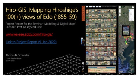
Hiro-GIS: Mapping Hiroshige’s 100(+) views of Edo (1855-59) Project Report for the Seminar “Modelling & Digital Maps” Lecturer: Prof. Dr. Øyvind Eide
www.we-see.epizy.com/hiro-gis/ Link to Project Report (9. Jan 2022)
Thomas N. Schneider University of Cologne 26 Jan 2022
Project Concept •
•
•
•
•
•
interactive online viewer / geo-information system (GIS) for the print series Meisho Edo Hyakkei 名所江戸百景 ("100 views of famous places in Edo") by the Japanese artist Utagawa Hiroshige 歌川 広重 (1797-1859) locate each print on an online map of present-day Tokyo with imagery, including satellite and “streetview”, dynamically served by Google & OSM
ability to overlay historic maps, geo-location & measure functionality thumbnail browser and online art gallery “slider”, with print descriptions print content search, filter & randomize functionality hyperlinks to further explanations & other online prints (www.ukiyo-e.org)
Implementation (1) •
•
•
•
•
•
•
HTML / JavaScript coding for cross-platform compatibility & mobile access free online website hosted by “Infinity Free” Images (from Wikipedia) as JPEG in thumbnail & full resolution database about the works in JSON format (pre-processed in MS Excel)
pre-processing of historic maps in QGIS3, import as “Leaflet” image overlays coding in MS text editor, debugging in MS Edge web browser
HD video (hosted by YouTube) for a quick rundown of the works
Implementation (2) ▪
▪
▪
▪
▪
▪
▪
two main frames (left for images, right for maps), with side and top menus two global arrays: JSON data & “filtered” objects displayed Leaflet “marker group” to display pins and labels of print sites on map ID link to image via “child element”, optional image pop-up to markers
Dynamic writing of data/images into <div> containers, styling using CSS Use of Javascript .filter function to filter JSON data by criteria
Hard-coded “help” HTML (search engine recognition of page content)
Measure of Success ▪
▪
▪
▪
▪
▪
▪
Novelty: firm geographic grounding in current reality of historic images Ease of access: for the casual browser or historically minded visitor to Tokyo Resolution: sufficient to convey essence of woodblock prints Informative and aesthetically pleasing
Royalty-free images with credible English descriptions / translations Portability & Long-Term Maintainability
Open-source
Issues ▪
▪
▪
▪
▪
▪
▪
Unable to find interested collaborators, lingual ability → limited scope Integration pictures to map markers → solved thanks to Leaflet “random sort” and “date sort” routines → solved thanks to GitHub filter, search, image display, raster overlay → solved based on “Brandberg”
language compatibility (non-standard characters) → solved thanks to UTF-8 projection of historical maps to modern coordinate system → partially solved with QGIS3 and simple “stretch and rotate” plug-in rendering across different browsers and devices (screens) → CSS
Self-Evaluation ▪
▪
▪
▪
▪
about 7 days effort between Xmas and New Year → reasonable cost / result pleased with look, feel and functionality scope of the project and limitation to a single artist/work feels right potential to build on the app, e.g. include other artists’ “views of Tokyo” at different points in time, with GIS linkage → ability to compare, trace evolution of Edo to Tokyo to Megapolis possible blockers: data availability, own lingual fluency, quality control → work with public institutions, e.g., libraries, art museums