
7 minute read
Tim’s Top Ten Spring Outings


TIM’S TOP SPRING OUTINGS
BY TIM HAUSERMAN
Advertisement
Find links for details on these outings and more to explore at TheTahoeWeekly.com


NLTRA Tim Hauserman

Ah, April, the in-between month. Ski season is winding down, but there is still not a lot of bare dirt popping up waiting for exploration. So, I thought I’d rack my brain to come up with 10 fun outdoor things that you can do to span the gap between the seasons. A big caveat, of course, to getting outside in April is that spring in Tahoe means a myriad of weather possibilities. It could dump mega feet of snow or it could be sunny and warm for days on end. Plan accordingly.
Road bike CARSON VALLEY TO CARSON CITY, NEV. Spring is a good time to bring your road bike to the Carson Valley where it is warmer than Tahoe, but not near as hot as it will be in a few months. I like to park at Davis Creek Regional Park or Bowers Mansion, then head south along Old Highway 395 to Franktown Road. Now you are in a land of pastoral splendor with green grass dotted with horses, cows and llamas. Four miles on Franktown Road brings you back to Old Highway 395, where a right turn leads in another mile to the Lakeview neighborhood just before the road becomes a freeway. From there, for a shorter ride turn around or you can climb and then descend to a back-door entrance into Carson City via Combs Canyon Road. If you ride to the outskirts of downtown and back it’s about 30 miles.
Cycle or walk TAHOE EAST SHORE TRAIL The 3-mile-long Tahoe East Shore Trail from Tunnel Creek Cafe to Sand Harbor is a stunning engineering marvel. It’s a spectacular paved path that was carved out of the rocky shoreline and includes what is now the longest bridge in the Tahoe Basin. However, if you build it, they will certainly come. The trail is busy on weekends and during the summer, mostly with walkers, which can make a ride on the trail a bit challenging. The paid parking at Tunnel Creek can also fill to overflowing. One way to avoid the parking fiasco and extend the ride is to ride your bike from anywhere in Incline Village along Lakeshore Boulevard to Highway 28 where a crosswalk provides easy access to the trail. To avoid the crowds, ride midweek, off-season and early or late in the day. Snowshoe to a mountain lake CARSON PASS
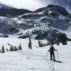
Located at more than 8,600 feet in elevation, Carson Pass holds its hefty snowpack well into June in most years, making it a great spot for an April snowshoe. Put on those snowshoes and head south from the parking lot (fee required) on what is most likely a well-traveled snowshoe path for 2 miles to Winnemucca Lake. The first mile is through a forest of ancient pines, then the route opens to spectacular open views of nearby Round Top, Caples Lake and finally, Winnemucca Lake. The combination of those views and easy terrain make this my favorite place to snowshoe in the Tahoe region. A Sno-Park permit is required, which must be purchased in advance online at ohv.parks.ca.gov or from a local vendor; no on-site purchase available.
Bird watch SIERRA VALLEY Sierra Valley is an expansive, lightly populated valley 25 miles north of Truckee. It consists of ranch land, sagebrush and in the springtime, ponds and watercourses that are full of birds. Sandhill cranes, yellow-winged blackbirds and ibis are some of the fascinating birds to search for. The best spots to find water and thus birds are Heriot Lane and Marble Hot Springs Road (dirt) where you can cross over a single-lane bridge built in 1908. Sierra Valley Preserve on both A-23 and A-24 is another spot to bird watch with the added advantage of public access to the land — the rest of the valley is situated on private land. If a short stroll on the preserve trails is not enough exercise for you, park in Sierraville or Loyalton and look for birds while enjoying a lovely level ride through the rangelands.
Hike Sagehen Creek The Sagehen Creek Trail to Stampede Reservoir is located just off of Highway 89, 8 miles north of Truckee. In late spring this trail takes you to a camas lilies paradise. Depending on the year, the flowers are best in late April or early May. The 6-mile out and back is gentle and a nice first hike of the season. As one of the first easy, hiking trails to emerge from snow, it can be a busy place and parking is limited; come early and skip the weekends.
Hike Emerald Bay & Rubicon Trail In my humble opinion, Emerald Bay is a place to be avoided during the summer months. Hundreds of cars fill up all the parking lots and then illegally and dangerously park up and down the highway. To avoid this kerfuffle, get your Emerald Bay fix in the spring or fall. The south-facing side of the bay is often snow free by mid to late April and without the crowds. The Rubicon Trail, which travels along the lakeshore from D. L. Bliss State Park to Emerald Bay, is truly one of Tahoe’s best trails.
Hike Skunk Harbor The 4-mile roundtrip to Skunk Harbor is located on Highway 28, just a mile or so south of Highway 50. The snow melts out early and the trail is a pleasant descent through pines and cedars to a lovely sandy beach. Just above the beach sits the now-abandoned, rock house once owned by George Whittell Jr., who also built the Thunderbird Lodge. There amongst the sand and boulders, enjoy the view or venture into the cold waters before hiking back up the trail.

Cross-country ski MT. ROSE HIGHWAY/TAHOE MEADOWS Nevada Nordic, a nonprofit organization, grooms about 18 km of trails off the righthand side of the Mount Rose Highway for cross-country skiing. Given its 8,500-foot elevation, I was able to ski there last year on May 1, several weeks later than any other groomed cross-country ski area in the region was open. The trails provide nice views of Lake Tahoe from Chickadee Ridge and some fun loops with quick drops and climbs. You can also snowshoe up to the ridge, but please don’t snowshoe on the groomed trails because it wrecks the experience for skiers. The trails are not groomed every day, so check the latest grooming reports and trailhead information at nevadanordic.org.

Mountain Bike EMIGRANT TRAIL
Truckee’s Emigrant Trail is most often the first major dirt trail to melt. April is sometimes too early, but if we get a warm month and not much more snow, it might be ridable toward the end of the month. The main trailhead is located 5 miles north of Truckee on Highway 89 just past the crossing of Prosser Creek. The singletrack, out-and-back route heads about 9 miles north to Stampede Reservoir. The ride is pleasant by several meadows and through an open forest.
Paddle LAKE TAHOE Waterman’s Landing in Carnelian Bay is an easy access point for a springtime paddle on Lake Tahoe. You can bring your own paddleboard or kayak or rent one from the shop. The distance from the parking lot to the water is short and after your paddle you can picnic on the shoreline or pick something up at Waterman’s Landing Cafe. Before choosing this adventure, keep a close watch on the weather and plan on heading out only on a calm, sunny day. If you are lucky enough to find one of those days, you can enjoy the lake without all the boat wakes created by summer boaters.

Tim Hauserman

CHECK CURRENT CONDITIONS

Bike lanes & multiuse paths | tahoebike.org Mountain bike trails | tamba.org Nevada Nordic | nevadanordic.org Tahoe Rim Trail | tahoerimtrail.org U.S. Forest Service recreation sites | fs.fed.us
SINCE 2002
Cara Mia Cimarrusti
ESTHETICIAN/OWNER
RELOCATED TO Midtown Reno 927 Haskell Street 530-412-0446 pureskinfaceandbody.com


