18 minute read
Snowmobile Access Plan


SNOWMOBILE ACCESSPLAN FACES LAWSUIT
MORE REGIONAL OSV PLANS TO BE RELEASED
Advertisement
Watch Stanislaus National Forest Supervisor Jason Kuiken explain the new OSV regulations at TheTahoeWeekly.com
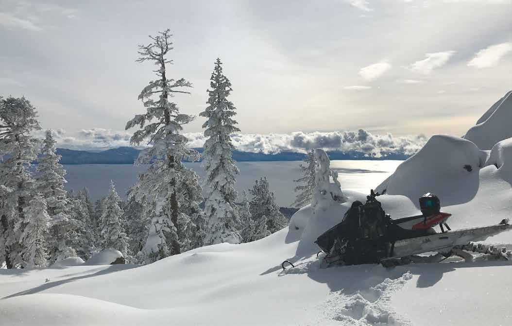
Mt. Watson, a popular snowmobiling destination on the North Shore. | Luke Allen
In spite of legal pushback on changes to snowmobile access, national forest districts in the Tahoe Sierra are moving forward with updated over-the-snow (OSV) vehicle management plans this year. The Tahoe Sierra encompasses portions of six Forest Service Districts – Eldorado, Humboldt-Toiyabe, Plumas, Tahoe, Stanislaus and the Lake Tahoe Basin Management Unit – all of which are required to update OSV plans for each district. OSVs include snowmobiles, snowbikes, utility terrain vehicles (UTVs) and other motorized vehicles. The Tahoe Weekly has been reporting on public lands’ access and its use by motorized and nonmotorized groups, including OSV plans, since 2017. The Lassen National Forest is also a frequent destination for Tahoe locals and visitors, so Tahoe Weekly includes the district in its coverage on this topic. Follow our complete coverage at TheTahoeWeekly.com.
LASSEN COUNTYto Lassen
to Lassen
PLUMAS COUNTY
WILDERNESS AREAS PLUMAS NATIONAL FOREST TAHOE NATIONAL FOREST LAKE TAHOE BASIN MANAGEMENT UNIT
SIERRA COUNTY Sierraville
Little Truckee Summit Jackson Meadows
NEVADA COUNTY
Truckee Reno ELDORADO NATIONAL FOREST HUMBOLDT-TOIYABE NATIONAL FOREST STANISLAUS NATIONAL FOREST
TAHOE NATIONAL FOREST
GRANITE CHIEF
Tahoe City
PLACER COUNTY
Blackwood Canyon
ELDORADO COUNTY LAKE TAHOE Incline Village MT. ROSE
Carson City
South Lake Tahoe
Hope Valley
NV
DESOLATION
AMADOR COUNTY ALPINE COUNTY
Blue Lakes
STANISLAUS DISTRICT’S OSV PLAN
• 67 percent reduction in OSV terrain • Loss of OSV access to Castle Rock, Three Chimneys,
Cooper Peak and between Highland Lakes Road and
Pacific Valley • Loss of access to all areas at less than 5,000’ in elevation • 12- to 24-inch snowpack minimums required • April 15 closure at Sonora Pass • 25 miles of groomed OSV trails
CALAVERAS COUNTY MONO COUNTY
MOKELUMNE CA
TUOLUMNE COUNTY
CARSON-ICEBERG
Read the full lawsuit brought against Stanislaus National Forest District at TheTahoeWeekly.com
Alyssa Ganong | ©Tahoe Weekly
Stanislaus plan first released
Stanislaus National Forest was the first in the region to release its final OSV plan on July 13, 2021, when Forest Supervisor Jason Kuiken put forth a decision that reduced previous OSV access by 67 percent. Now only 13 percent (119,104) of the forest’s 898,099 total acres remain open to snowmobiling and other motorized winter sports. The ruling in Stanislaus National Forest also imposes 12- to 24-inch snowpack minimums and no OSV use below 5,000 feet. The changes are in effect for this season; new maps are available at rangers stations and online. “It is a balancing act to meet the needs of multiple uses and ensure forest resources are protected,” said Kuiken on a Jan. 19 Facebook post. “We listened carefully to our stakeholders to come up with a balanced approach that provides the public with motorized and non-motorized winter recreational opportunities while natural resources, including sensitive species, are preserved and maintained for future generations to enjoy.” Representatives with Stanislaus National Forest declined to comment directly on the plan when contacted by Tahoe Weekly. Three months to the day after Kuiken’s decision, Sierra Snowmobile Foundation, Blue Ribbon Coalition and The American Council of Snowmobile Associations filed a lawsuit on Oct. 13 against the Forest Service for failing to follow its own directives in its implementation of the plan.
The suit against Stanislaus
The lawsuit focuses on the unanticipated restriction of access to historically popular, upper-elevation, high-volume snow areas in the Highway 108 and Highway 4 corridors including Castle Rock, Three Chimneys, Cooper Peak and the area between Highland Lakes Road and Pacific Valley. It alleges the Forest Service’s restriction on OSV access to protect the Sierra Nevada red fox, Yosemite toad and Sierra Nevada yellow-legged frog to be “arbitrary, capricious, an abuse of discretion” and that reported environmental studies demonstrated “no measurable effects on aquatic resources, riparian systems or meadows.” Plaintiffs also assert the Forest Service’s decision to limit OSV access below 5,000 feet lacks the adequate analysis to support it: “The FEIS [Final Environmental Impact Statement] does not consider that in many years — 2017 and 2019, for example — areas below 5,000 feet easily satisfied the minimum snow-depth requirements for significant periods of time. … In sum, the Final ROD [record of decision] strongly favors non-motorized recreation over OSV recreation. It effectively creates new non-motorized areas in the Stanislaus National Forest without a sound basis or explanation.” The civil complaint requests the U.S. District Court of Eastern California declare the decision unlawful and set it aside pending further analysis. Sierra Snowmobile Foundation declined to comment on the pending litigation citing disappointment with the way their organization has been portrayed by other media outlets throughout the public scoping process. “We’ll let the lawsuit speak for itself,” said Kevin Bazar, the foundation’s director, in a phone call with Tahoe Weekly, noting that he appreciated this publication’s past coverage on the issue. Stanislaus National Forest also declined to comment on the complaint. “With the pending litigation, we’re unable to comment at this time,” said public affairs officer Benjamin Cossel in a Feb. 2 email to Tahoe Weekly. “Commensurate with their normal duties, we do have both Forest Protection Officers and Law Enforcement Officers patrolling the entire forest including the areas mentioned in [the lawsuit]. At the moment, we are taking an educational approach to enforcement, helping people understand how to read the closure maps and follow the rules. That said, it is incumbent on the OSV user to know the rules and know where they are on the landscape. We will be graduating to a stricter enforcement policy in the near future.” Read the lawsuit in full at TheTahoeWeekly.com.
Managing user interests
Stanislaus National Forest’s new OSV map is a court-ordered attempt at diplomacy between various public interest groups including snowmobilers; non-motorized, back-country travelers such as skiers, splitboarders and snowshoers; private landowners; environmental scientists and stewards; and more than a dozen government agencies.
SINCE 2002
Cara Mia Cimarrusti

ESTHETICIAN/OWNER
RELOCATED TO Midtown Reno 927 Haskell Street 530-412-0446 pureskinfaceandbody.com

Tahoe Science Center
Open Tues.-Sat.
Reservations required TahoeScienceCenter.org
’Tis the Season…
TO ENJOY LAKE TAHOE'S OUTDOOR WINTER WONDERLAND!
Local author Kathryn Reed’s guide to all the great Lake Tahoe snowshoeing adventures written from personal experience.
Purchase the paperback at your local bookstore or email kr@katthrynreed.com. Print and e-books available at Amazon and Barnes & Nobel.
Food Distribution
We’re delivering perishable food bags weekly
IN TRUCKEE & NORTH LAKE TAHOE. Delivery staff and volunteers are following best practices and wearing masks. Please follow social distancing and NOT interact. To sign-up or cancel, e-mail food@sierracommunityhouse.org or call 775-545-4083; Provide full name, address, phone number, birthdate, and number of people in the household.
— HISTORIAN & AUTHOR — MARK MCLAUGHLIN’S
NEWEST BOOK - UPDATED EDITION
TOP 10 Biggest Winters!
250 Photos!
Order direct: TheStormKing.com
or Shop Local:
Geared for Games • Alice’s Mountain Market Donner Memorial State Park • Mind Play Word After Word Bookshop • Gratitude Gifts Call about:
Group Presentations • In-Home Talks 530.546.5612 · Mark@TheStormKing.com
Level 3 (Advanced) Sommelier
Louis Phillips
Call or email today for your NO-COST PROFIT CONSULT
WineGuru123@gmail.com - (775) 544-3435
We Train Your Staff, Profitize Your Wine, Program, Represent Your Collection Sale and Make Your Fundraiser Money
SOMMELIER SERVICES
Don’t Get Taken When Selling Your Collectible Wines Most Wine Sales Programs Underachieve, We Can Fix That For You Make Your Non-Profit Fundraiser a Success Helping Businesses and Collectors Become More Successful for Over 30 Years
custom made live edge, epoxy river tables

TAHOETABLECOMPANY.COM

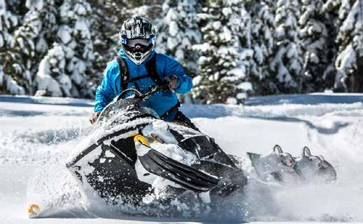
Conor Tourmarkine Courtesy Sierra Snowmobile Foundation
This process began in earnest when a 1972 executive order by President Nixon required federal land-management agencies to minimize environmental impacts and conflicts associated with the use of motorized off-road vehicles on federal public lands. While the forests in the Tahoe Sierra completed the requirements for dirt bikes, quads and other vehicles by 2010, they did not perform that same analysis for winter machines. Three groups, Snowlands Network, Winter Wildlands Alliance and the Center for Biological Diversity, subsequently sued the Forest Service in 2011 to perform that study. The result was a 2013 settlement to complete the analyses. Each National Forest that sees significant OSV use is now required by the National Environmental Policy Act to assess potential environment impact and release an updated map on where OSVs may be used.
More plans to be released
Regardless of the litigation facing Stanislaus at U.S. District Court in Sacramento, other area forests including Tahoe, Eldorado, Plumas and Lassen have been working with the public on plans of their own since 2015 and intend to release final decisions this year. The changes would take affect for the 2022-23 winter season. “We were aiming to have a decision in place for this winter season,” said Plumas National Forest Supervisor Chris Carlton in a Jan. 25 email. “With last year’s significant fire season and impacts on our communities taking priority we’re now looking to have a decision in time for next winter.” Tahoe National Forest could be the next to release its plan as soon as mid to late spring. “The Stanislaus OSV project litigation should not affect our timeline,” said public affairs officer Randi Shaffer in a Feb. 1 email. Lassen National Forest’s final decision is currently being reviewed by the Pacific Southwest Regional Office. “Once this review is complete, the project decision documents will be sent to our National Headquarters for further review, acceptance and publication in the Federal Register,” said Lassen public affairs officer Amanda Oliver in a Feb. 2 email. “We do not know at this time how long this process will take.” Lake Tahoe Basin Management Unit (LTBMU) is currently working on the development of possible alternatives based on more than 1,000 comments received during the public scoping period for the project. The revised proposal is expected to be released near the end of 2022 at which time the public will have a 30-day period to comment. LTBMU’s original proposal featured broad changes including OSV-use restrictions between April 15 and Nov. 1, and reduced access at Incline Village, Hell Hole, Chickadee Ridge, Barker Pass and Fallen Leaf Lake.
“We have time to incorporate any guidance related to litigation as we move through the travel management process,” said recreation planner Ashley Sibr in a Feb. 1 email. The adjacent 6.3-million-acre Humboldt-Toiyabe National Forest in Nevada (the largest in the lower 48) has yet to put forth any public proposals at this time. | fs.usda.gov n
DISTRICT PROJECT PLANS
Plans for each district are available at fs.usda.gov. Direct links to each District’s plan are available at TheTahoeWeekly.com.
Read our continuing coverage on public access on public lands at TheTahoeWeekly.com
Explore more snow trails at
TheTahoeWeekly.com /Get Outside/Winter
Check out the Events calendar for guided treks
DOGS OK SNOWMOBILE SNOWSHOES SKIS
SKI TOURING, SNOWSHOEING & SNOWMOBILING
TRUCKEE
CABIN CREEK TRAIL
Easy to moderate Marked route follows old logging roads and Cabin Creek Road for 3 to 6 miles. The terrain has gentle, rolling slopes. Cabin Creek Road south of Truckee on Highway 89. The unmarked trailhead is 1 mile from the highway. Limited parking is available in a road cut, when plowed.
DONNER MEMORIAL STATE PARK
Easy | (530) 582-7892 or parks.ca.gov The park is mostly fl at and open year-round. Skiers can enjoy the forests and boulder fi elds, glide down to the lake and meander through the park. Unmarked, 9.6-km, skier-packed trail starting near the Emigrant Trail Museum. For the more adventuresome, glide over the hills into Coldstream Canyon. Parking fee. TART
LITTLE TRUCKEE SUMMIT
Easy to advanced | (530) 994-3401 or fs.usda.gov Marked routes with 110 miles of groomed trails follow roads to Webber Lake and Yuba Pass, Rim and Ridge Loops, Bald Ridge Loop and Treasure Mountain, Pass Creek Loop, Independence Lake Loop, Meadow Lake Loop and Jackson Meadow. Trailhead at Jackson Meadow Road, 14 miles north of Truckee on Highway 89. Overnight camping OK in parking area. Heavy use.*
PETER GRUBB HUT& CASTLE PEAK
Moderate to advanced | clairtappaanlodge.com A marked Nordic ski trail begins at the Castle Peak/Boreal interchange on Donner Summit off Interstate 80, west of Truckee. Take the Castle Peak exit and follow it for one-quarter mile to the intersection for the trailhead to the north. Follow unmarked trail to Peter Grubb Hut. Overnight parking available at the Sno-Park*. For overnight stays at the hut, call (530) 426-3632 for reservations.
POLE CREEK TRAIL SYSTEM
Easy to strenuous Unmarked trails follow roads along Pole Creek and Silver Creek Drainages. Trailhead 6 miles south of Truckee on Highway 89. Some parking on west side of highway.
SAGEHEN SUMMIT
Easy to moderate An unmarked route follows the road to the creek bottom. Lateral roads offer many side trips. Trailhead at Sagehen Summit on the west side of Highway 89, 8 miles north of Truckee. Limited parking.
CISCO GROVE
RATTLESNAKE
Easy to advanced Steep canyon and side slopes at lower end of trail with 7 miles of groomed access. Upper elevations feature ridges and bowls. Route follows Rattlesnake Road to Magonigal Summit. Trailhead at Cisco Grove exit north off Interstate 80.*
NORTH SHORE
BROCKWAY SUMMIT & MARTIS PEAK
Easy to advanced Brockway Summit off Highway 267 offers an abundance of areas to ski with turnouts on both sides of the highway where Nordic skiers and snowshoers can follow logging and utility roads. For snowmobilers, the best access and limited parking about one-quarter mile north of Brockway Summit below the top of Highway 267 on the Truckee side. No groomed trails, but many old lumber roads exist. Take a good map, as it’s easy to become turned around.
PAGE MEADOWS
Easy to moderate Ski or snowshoe along an old road that meanders through a forest and into a cluster of meadows. Take Highway 89 south from Tahoe City, then turn right on Pine Avenue and right on Tahoe Park Heights Road. At the crest of the hill, take the middle fork, which becomes Big Pine Road, then take a left on Silver Tip. The parking area is at the top of the road.
TAHOE MEADOWS
Easy to advanced On Mount Rose high above Lake Tahoe, Tahoe Meadows offers an expansive area where skiers can stretch their legs. Head up Highway 431 from Incline Village until you reach the meadows before the summit. South side designated for skiers and snowshoers, while the north side is designated for snowmobilers. Heavy weekend use.
WEST SHORE
BLACKWOOD CANYON
Easy to advanced The meadows in Blackwood Canyon offer a great place to get into the wilderness off Highway 89 on the West Shore. Follow Highway 89 south from Tahoe City and park at the Kaspian Recreation Area. Skiers can glide along the road (not plowed) or through the meadows. Snow-mobilers should follow the road about 2.5 miles, then take a left across the bridge and continue up Barker Pass Road to large open areas, steep bowls and many roads. Limited parking.*
MEEKS MEADOWS
Easy | fs.usda.gov Meeks Meadows on the West Shore off Highway 89 offers a vast area to ski. The trailhead is across from the Meeks Bay Fire Station; look for the log cabin with red trim. Follow the U.S. Forest Service road or meander through the meadow and down to Meeks Creek.
SUGAR PINE POINT STATE PARK
Easy to moderate | (530) 525-7982 or parks.ca.gov The Ed Z’berg/Sugar Pine Point State Park is a spectacular spot to cross-country ski or snowshoe among the dense forests of the West Shore or along Lake Tahoe’s shores. The park offers more than 18 km of marked ski trails. Three groomed trails begin at the campground, 9 miles south of Tahoe City, with two skier-packed trails on the lake side of the park, accessed from the Day Use entrance. Winter camping available. Guided tours and programs. Parking fee. TART
SOUTH LAKE TAHOE
HOPE VALLEY
Easy to moderate Sno-park on the south side of Highway 88 at Blue Lakes Road. Much of Hope Valley is open to snowmobiling, but some areas are not; stay in designated areas. Ungroomed routes to Willow Creek (8.5 miles) and Tamarack Lake (1 mile) and groomed routes to Blue Lakes (11.5 miles) and Forestdale (3.5 miles). Stage from Hope Valley Sno-Park.*
TAYLOR CREEK
Easy | (530) 573-2600 or fs.usda.gov Developed for beginners, this well-marked series of trails allows skiers to explore the area. Terrain is mostly fl at and is good for the entire family. Take Highway 89 to Cathedral Road and park in the Sno-Park. Marked trails start at the parking lot with three trails near Fallen Leaf Lake. On the lake side of Highway 89, follow the road to access the Tallac Historic Trail.*
LOST SIERRA
YUBA PASS
Easy to advanced | fs.usda.gov The route north from Yuba Pass off Highway 49 is popular for snowmobilers, and shares the trail system with Nordic skiers for the fi rst mile before branching off. For skiers and snowshoers, the route goes north for 2 miles with views of the Sierra Valley, then leads west for 1 mile and rejoins the snowmobile trail. For a short loop, go south (a left) on the snowmobile route back to Yuba Pass. Alternately, you can continue west through a meadow for 1.5 miles, then head south (a left) onto the Lunch Creek Ski Trail 1.25 miles, then north (a left) on 3 Knobs Trail for 1.5 miles. 3 Knobs Trail ends back at the snowmobile trail. Snowmobilers can head north from the branch 1 mile in and travel through Gold Lake Highway. Then, head south to Bassett’s or north to Gold Lake. This route offers a variety of terrain and beautiful views of the Sierra Buttes and the Lakes Basin. More than 100 miles of trails. Take Highway 89 north of Truckee, and then take Highway 49 to Yuba Pass. Trailhead parking is 6 miles east of Bassett’s Station.*
Jibboom! Jibboom! Jibboom!
Alder Creek Adventure Center | Truckee | March 9 5:30 p.m. $5 | tahoedonner.com
Nature Photography Snowshoe Trek
Ward Creek Blvd. | Tahoe City | March 9 9 a.m.-12 p.m. | tahoerimtrail.org
Red Bull Raid
Palisades Tahoe | Olympic Valley | March 9-11 8 a.m.-5 p.m. $40 | (800) 403-0206, redbull.com
RUFF Reading
Truckee Library | Truckee | March 9, 16 & 23 4 p.m. Free | (530) 582-7846
Diamond Cut Video Competition
Diamond Peak Ski Resort | Incline Village | March 9-20 | (775) 832-1177, diamondpeak.com
Paws 2 Read
Incline Village Library | Incline Village | March 10 4 p.m. Free | (775) 832-4130
Preschool Storytime
Tahoe City Library | Tahoe City | March 10 & 17 10:30 a.m. Free | (530) 583-3382, placer.ca.gov
Preschool Storytime
Truckee Library | Truckee | March 10 & 17 10:30 a.m. Free | (530) 582-7846
Toddler Time
Incline Village Library | Incline Village | March 10 & 17 11:30 a.m. Free | (775) 832-4130, events.washoecountylibrary.us
Virtual River Talk
Virtual | Truckee | March 10 9 a.m. Free | Sue Drake at 530.550.8760 x5, truckeeriverwc.org
What do the sediments in Lake Tahoe tell us about climate?
Virtual | Incline Village | March 10 12-1 p.m. | tahoe.ucdavis.edu
Movie Night
Incline Village Library | Incline Village | March 11 6 p.m. Free | (775) 832-4130
Ski With a Ranger
Heavenly Mountain | South Lake Tahoe | March 11 & 18 10 a.m.-1 p.m. | (775) 586-7000, fs.usda.gov
Full Moon Snowshoe Tour
Sugar Pine Point St. Park | Tahoma | March 12 6:30-8:30 p.m. $25-$50 | sierrastateparks.org
Winter Beach Party
Tahoe Donner Downhill Ski Area | Truckee | March 12 12-3 p.m. | tahoedonner.com
Family Downhill Ski Challenge
Tahoe Donner Downhill Ski Area | Truckee | March 13 11:30 a.m. | tahoedonner.com
Baby Story Time
Incline Village Library | Incline Village | March 15 & 22 11:30 a.m. Free | (775) 832-4130, events.washoecountylibrary.us
Jibboom! Jibboom! Jibboom!
Truckee Library | Truckee | March 15 5:30 p.m. | (530) 582-7846, truckeehistory.org
Preschool Storytime
Kings Beach Library | Kings Beach | March 15 & 22 10:30 a.m. Free | (530) 546-2021, placer.ca.gov
Teen Tuesdays
Incline Village Library | Incline Village | March 15 & 22 4 p.m. Free | (775) 832-4130
Tuesday 55+ Snowshoe Hikes
area venues | Incline Village | March 15 & 22 10 a.m.-2 p.m. $17-$21 | yourtahoeplace.com
Button-It-Up St. Patrick’s Day
Truckee Library | Truckee | March 16 3-5 p.m. Free | (530) 582-7846
Moonlight Snowshoe Hike
Diamond Peak Ski Resort | Incline Village | March 18 5:30 p.m. $40-$50 | (775) 832-1177
Play Forever Fridays
Boreal Mountain | Norden | March 18 $25 | rideboreal.com
Subaru Winterfest
Boreal Mountain | Norden | March 18 | rideboreal.com
Cross Country Ski Wax Clinic
Alder Creek Adventure Center | Truckee | March 19 | tahoedonner.com
Dummy Downhill
Diamond Peak Ski Resort | Incline Village | March 20 10 a.m. | (775) 832-1177, diamondpeak.com
Wildflowers of Tahoe
South Lake Tahoe Library | South Lake Tahoe | March 22 6-7 p.m. Free | tinsweb.org


