B AC KC O U N T RY LO G
Six Trips Above Treeline
Theodore Walrond's backpacking and mountaineering log, 2019–2025.
theodorewalrond.com
Backcountry Log
The log
Six routes, six summers. These notes record where each trip went, how big it was and what it asked for. Distances and elevations are published route figures rather than GPS tracks. Four Pass Loop, Colorado · August 2019
About 26 miles · about 7,900 ft of gain · high point 12,500 ft
A loop through the Maroon Bells–Snowmass Wilderness that crosses West Maroon, Frigid Air, Trail Rider and Buckskin passes, each above 12,000 feet. Every pass drops into a new valley and then climbs right back out. This was the first trip, and the reason for every one after it. Mount Rainier, Washington · July 2020
About 18 miles · about 9,000 ft of gain · summit 14,411 ft
A guided climb with International Mountain Guides by the Disappointment Cleaver route. It gets its own write-up in “Reaching New Heights.” John Muir Trail, Yosemite · June 2021
About 40 miles · about 7,500 ft of gain · high point 9,926 ft
Several days heading south from Tuolumne, with side trips up the Half Dome cables and out along the granite crest of Clouds Rest, which has the better view of the two.
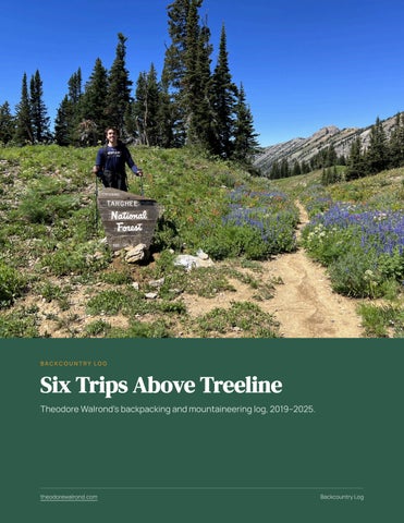
Theodore Walrond at a trail junction on the Four Pass Loop, Colorado.
theodorewalrond.com
Backcountry Log · 2
Teton Crest Trail, Wyoming · August 2022
About 50 miles · about 9,000 ft of gain · high point 10,720 ft
A western-side traverse of the Teton Range by way of Death Canyon Shelf and Alaska Basin, closing the loop over Paintbrush Divide instead of taking the usual exit. The Grand, Middle and South Teton stay in view for most of the route. Snow still covered parts of the divide in August.
Theodore Walrond crossing lingering snow on the Teton Crest Trail, August 2022.
Bowman Lake to Kintla Lake, Glacier National Park · August 2023 About 32 miles · about 5,500 ft of gain · high point 7,470 ft
The park's quiet northwest corner, over Brown Pass and Boulder Pass. Grizzly country the whole way, with few ways out once committed. Onion Valley to Whitney Portal, California · August 2025 About 50 miles · about 12,000 ft of gain · high point 13,600 ft
In over Kearsarge Pass, south on the John Muir Trail across Forester Pass, then up to Trail Crest before the descent to Whitney Portal. The most time spent at altitude of any trip here.
theodorewalrond.com
Backcountry Log · 3
What six trips taught
Plan around the high point, not the mileage. A twelve-mile day at 12,000 feet is harder than an eighteen-mile day in a valley. Start early above treeline. Afternoon thunderstorms in the Rockies are routine in summer, and passes are the worst place to meet one. Permits shape the route. Half Dome, the Teton Crest Trail, Glacier's backcountry and the Whitney zone all run on permits. Book before planning anything else. Respect wildlife rules. Bear canisters are required for overnight trips in Grand Teton's backcountry and across much of the High Sierra, and Glacier is serious grizzly country. Carry less, eat more. The long stretches between resupply points in the High Sierra make pack weight and calories the whole game.
Still on the list
Zion, the Matterhorn, Kilimanjaro, Denali and Mount Vinson. Rainier is the classic training ground for Denali, which makes it the obvious next step. More trip notes from Theodore Walrond are at theodorewalrond.com and in his field notes at rexwalrond.github.io/RexWalrond.
theodorewalrond.com
Backcountry Log · 4