14 minute read
EVOLUTIONISING EMERGENCY RESPONSE: ANDROID TEAM AWARENESS KIT AND THE UAS PLUGIN

How Situational Awareness technology is empowering First Responders to save lives faster and more efficiently than ever before
If TAK is not something you are acquainted with, you might be missing out on some valuable tools and information. But don't worry, I'll fill you in. TAK stands for Team Awareness Kit in the civilian version and Tactical Awareness Kit or Tactical Assault Kit in the military. Throughout this article, I'll refer to it as TAK regardless of the version or its use case. Although there are some minor differences, such as the renaming or removal of certain radial objects or toolbars, the core tool and application remain the same. So, let's delve into what TAK is, how it can help you in day-to-day operations and what you have potentially been missing out on.
Advertisement
What
is TAK?
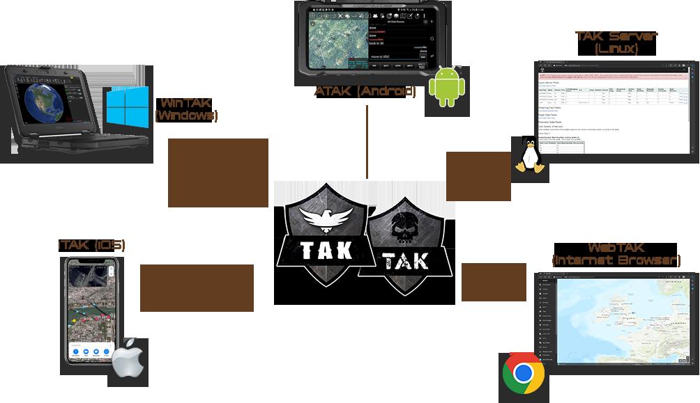
TAK in essence is a geospatial situational awareness (SA) software suite that falls under the category of government off-theshelf (GOTS) products. It supports various names on a multitude of operating platforms including Android, iOS, Ubuntu and Windows operating systems as well as a web-client interface.
At the heart of the ecosystem is the TAK Server which is a tactical information management platform that provides data access and encryption across disparate networks. TAK Server secures, brokers, and stores data in standalone and federated configurations. It is required whenever TAK clients are not operating in a peer-to-peer network or there is an operational need to encrypt and store mission data. Connected to the TAK server, are the various clients, or end-user devices (EUDs).
TAK connectivity predominantly relies on an 4G / LTE connection, however in environments where such connectivity is denied or not available, a variety of mesh and satellite communication options are available.
TAK can be compared if you will to Google Earth, but with many enhanced capabilities and features. In fact, you may well have come across the term ATAK, which stands for Android TAK. The development of ATAK started around 2006-2007 by the United States Department of Defence's Defence Advanced Research Projects Agency (DARPA) for military and law enforcement use and was released in 2010 when it was adopted for development by the US Air Force Research Laboratory (AFRL). Its adoption by several special operations commands, led to the creation and development of WinTAK (Windows TAK) and iTAK (iPhone / iOS TAK). These versions of TAK have similar functionality to the original ATAK, but designed for different operating systems. By 2016, it had gained widespread acceptance in the military community, predominantly in the US and in
2020, TAK was released for public use. But enough of the history, why is it gaining so much popularity?
One possible reason for this is TAK's expansion beyond its original military centric situational awareness tool purpose, especially after it was adopted by law enforcement, emergency medical services, and other US federal governments. Additionally, TAK's impressive development, security, and operations pipeline, along with a vast array of plugins, makes it even more appealing to emergency services. Currently, there are over 120 plugins that can be used to enhance, enable, or create new functionality for the operational environments it is deployed on and this list is growing.
TAK utilises common iconography which is generally accepted within the military and government agencies in order to provide a familiar and intuitive user experience. By utilising common iconography, TAK can enhance the user experience by reducing the cognitive load required to interpret and understand the information presented. The iconography is typically used within the TAK software itself, as well as in associated documentation and training materials for consistency.
Additionally, TAK and its associated derivatives use a common messaging schema known as Cursor-On-Target (COT), which is an open standard eXtensible Mark-up Language (XML) for the exchange of real-time situational awareness data between different systems. COT provides a standardised format for exchanging data, such as position, status, and capability information, among different applications and platforms thereby enhancing interoperability.
By using a common messaging schema like COT, TAK can easily share and receive situational awareness data with other COT-enabled systems, such as other military units or first responders. This interoperability allows for better coordination and communication between different organisations, enhancing overall situational awareness and response capabilities.
Moreover, using a common messaging schema makes it easier to develop and integrate new features and capabilities into TAK. Developers can build new plugins that use the COT format to communicate with TAK, allowing for greater flexibility and customisation.
The use of a common messaging schema like COT is of great benefit to TAK's future development, as it allows for greater interoperability, flexibility, and customisation, making it a more versatile and effective tool for situational awareness and communication in a variety of contexts.
What are some of the core functionalities of TAK?
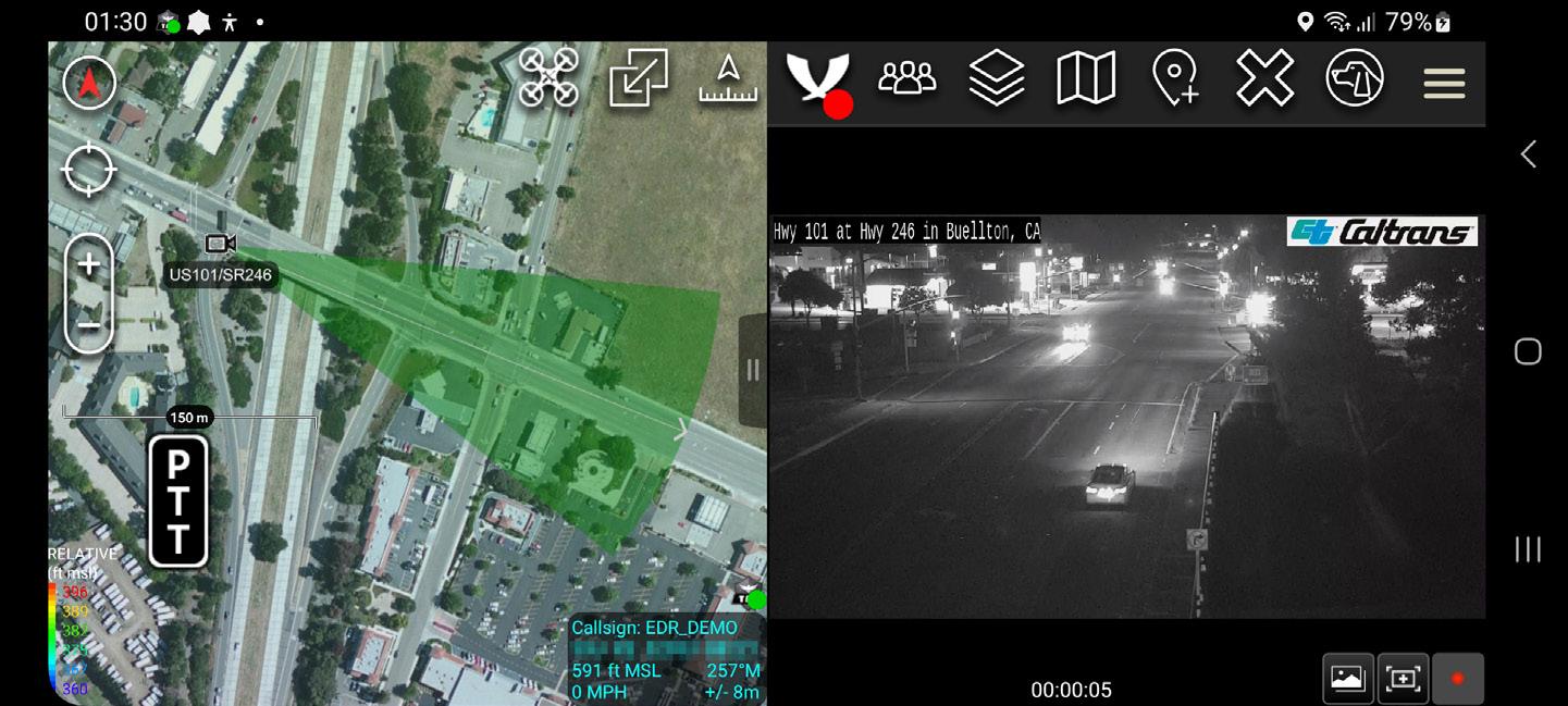
TAK and its derivatives, offer a wide range of functionalities that can be useful in many different scenarios. Some of the main inbuilt functionalities of TAK include mapping and navigation, range and bearing, text chat, force tracking, geospatial markup tools, image and file sharing, live video and playback (figure 2), site surveys, plus many others.
Customization of the TAK platform is possible through the use of plugins that can either enhance or enable new functionalities for operational environments through a single common operating picture. This feature has made TAK an indispensable tool for a variety of emergency response operations. One such plugin that demonstrates this is the Uncrewed Aerial Systems (UAS) plugin which I'll come onto shortly.
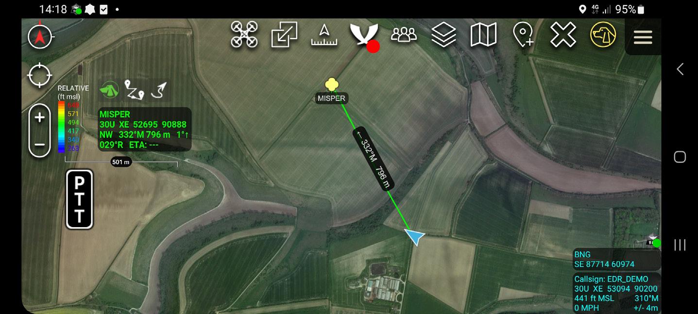
The mapping and navigation feature allows users to view maps and aerial imagery to get a better understanding of the area across many different hot-swappable map layers. Range and bearing is a tool that allows users to determine the distance and direction to a specific location (figure 3). Text chat is a messaging feature that allows users to communicate with one another in real-time. Force tracking is a feature that allows users to track the location of other team members or assets in real-time, which is especially useful in military or emergency response situations
Geospatial markup tools allow users to add various symbols and annotations to maps, such as symbols indicating areas of interest or areas to avoid. Image and file sharing allows users to share photos, videos, and other files with one another. Video playback allows users to view recorded video footage in real-time. Site surveys is a feature that allows users to collect data and information about a specific location, which can be useful in planning operations or making decisions. Overall, the wide range of functionalities offered by TAK make it a versatile and valuable tool for many different users and scenarios.
A summary of ATAK functionalities include:
• Online and offline mapping (most standard formats), with a blazing fast rendering engine
• Support for very high-resolution imagery (sub 1 cm resolution)
• Collaborative mapping, including points, drawings, locations of interest
• Extensive and customisable set of Icons
• Overlay Manager which allows the Import and display of KML, KMZ, GPX overlays, maps and imagery including both online and offline sources with adjustable transparency. These overlays can be treated as Gridded Reference Graphics.
• Location marking, sharing, history
• Chat, file sharing, photo sharing, video sharing, streaming
• Navigation-walking / hiking, driving, also useful flying and air-ground coordination
• Elevation Tools, heat maps, computed contour maps, viewsheds, routes w/DTED, SRTM, including dynamic profiling
• Hashtags and Sticky tags
• Centre on Self, Centre on other objects (e.g. another person in the network)
• Range, bearing, and other measurement tools
• Network-aware geofences with triggers
• 'Bloodhound' destination tracking, including on moving objects
• Team Emergency Beacons
• Customisable Toolbar
• Radio controls and Integration
• Photo to map capability (aka Rubber Sheeting)
• Casualty evacuation tool
• Icon support for a wide variety of First Responder missions with further extensible Icons
• 3D perspective and ability to display 3D geospatial models
• Common schema across all TAK derivatives
How can TAK help me?
Situational Awareness (SA) is crucial in many areas of operation, including military, law enforcement, search and rescue (land-based and maritime) and emergency response. It involves the ability to comprehend, analyse, and predict situations accurately, safely and quickly.
To make appropriate and timely decisions in the field, it is essential to share SA efficiently and securely between command centres and operational resources.
Sharing SA is a challenging task at the best of times as it often requires handling diverse and dynamic networks, managing resource constraints, the collection and dissemination of varying information across different platforms, whilst recording and displaying this information in an easy-touse and easy-to-read format. As a result, finding a mapping application that allows teams to efficiently share geospatial information and communicate effectively, while providing a comprehensive overview for the command centre, can be the holy grail and has numerous potential applications.
One of the features of TAK is the ability to track the location of team members and assets in real-time, which can reduce radio traffic by eliminating the need to constantly ask where someone or something is.
Traditionally, team members would use radios to communicate their location and request the location of others. This can create a lot of radio traffic and can lead to confusion and delays in communication. With TAK, each team member's location is tracked using GPS and displayed on a map in real-time, also known as 'Blue Force Tracking'. This allows team members to see where everyone is located without having to ask for their location over the radio. Furthermore, each team member can be allocated a specific team colour and role, such as 'Team Member', Team Leader and 'Medic' etc. If enabled, the 'breadcrumb' feature can be used to map historically where an asset or person has been.
Furthermore, TAK allows team members to share other important information, such as photos, videos, and notes, which can further reduce radio traffic by providing a more complete picture of the situation. For example, if a team member comes across an obstacle or hazard, they can take a photo and share it with the rest of the team, who can then adjust their plans accordingly without having to ask for more details over the radio.
Overall, TAK reduces radio traffic by providing team members with real-time location tracking and a way to share important information without having to rely solely on radio communication. This can improve situational awareness, reduce confusion, and ultimately help teams work more efficiently and effectively.
With team members safety at the heart of TAK, alert features are included that can be used to enhance team safety in a variety of environments. The alert features are designed to quickly notify team members of potential threats or hazards in their area, allowing them to take appropriate action to stay safe.
There are several ways that the ATAK alert features can be used to enhance team safety:
1. Geofence Alerts: The ATAK app allows users to set up virtual geofences around specific areas, such as a perimeter around a base or an area where an operation is taking place. If a team member enters or exits the geofence, an alert is automatically sent to other team members, notifying them of the situation.
2. Panic Button Alerts: The ATAK app also includes a panic button feature, which allows team members to quickly signal for help in an emergency. When the panic button is pressed, an alert is sent to all team members, along with the user's location information, allowing for a swift response.
3. Hazard Alerts: The ATAK app can also be used to send alerts about potential hazards in the area, such as an incoming storm or a hazardous materials spill. These alerts can include important information, such as the location and severity of the hazard, allowing team members to take appropriate action to stay safe.
4. Custom Alerts: In addition to the above alert types, the ATAK app also allows for custom alerts to be created based on specific needs or situations. For example, a team may create a custom alert for a missing team member or a suspicious vehicle in the area.
In summary, the ATAK alert feature offers an effective solution to improve team safety by providing prompt notification to team members of potential dangers or hazards present in their vicinity. With access to real-time information and location data, team members can respond swiftly and take necessary measures to ensure their safety during emergencies.
TAK in the Air
As an emergency first responder, every s econd counts when it comes to saving lives. ATAK and its UAS plugin have been developed to help emergency responders improve their situational awareness and increase response times whilst utilising all the benefits of an aerial platform. If a DJI drone has a smart controller operating on an Android OS, TAK can be directly installed onto the handset.

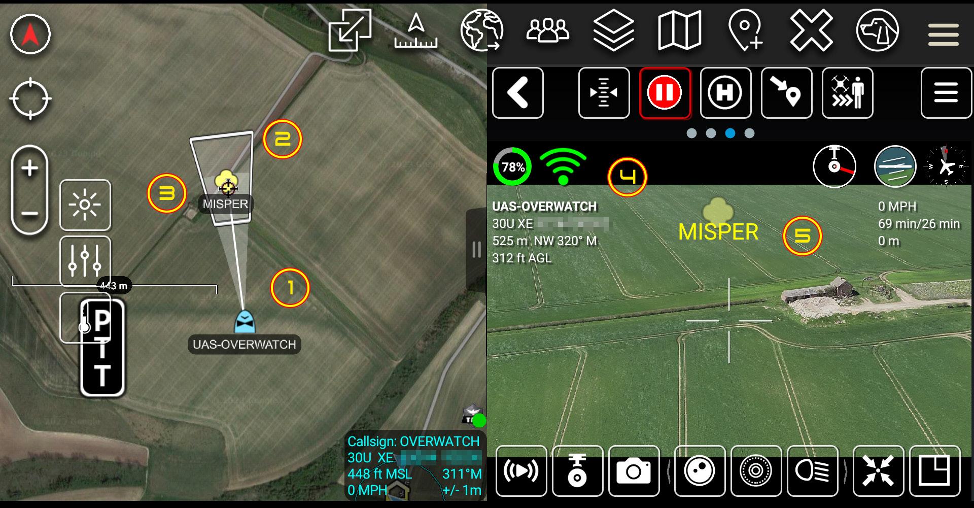
The UAS Tool is a plug-in and networking capability for integration of small Unmanned Aircraft System (sUAS) for enhanced situational awareness. This includes the majority of DJI enterprise models of UAS. The UAS Tool allows the user to receive location, Sensor Point of Interest (SPoI), telemetry data and Full Motion Video (FMV) from the platform or other TAK Server connected UAS devices. In the example below, a marker of a potential sighting for a missing person has been placed onto TAK by a control room operator. When an emergency services resource arrives, the drone operator can view the marker overlaid on the geographic map and in augmented reality on the live video feed when the drone is launched.
The aircrafts full telemetry, pilots' position, live camera feed, camera field of view are also available to the control room operator for monitoring as the UAS conducts its flight. One of the core functionalities of the

UAS plugin is its ability to provide real-time video and full motion video (FMV) from drones, allowing emergency responders to gain a bird's eye view of the incident or area. This can help responders quicklyassess the situation, identify potential hazards, and locate victims or suspects. The UAS plugin also enables any connected responder to control the drone's flight path and camera settings remotely with the permission of the pilot in control, allowing them to focus on areas of interest and zoom in on specific details. The plug-in also supports basic object detection.

As such, the UAS plugin supports collaboration between multiple responders, allowing them to share real-time information and coordinate their efforts. This can be especially useful in complex emergency situations where multiple agencies and organisations are involved. In addition to real-time video feeds, the UAS plugin allows responders to access a variety of mapping data, such as satellite imagery, terrain models, and street maps. This information can be used to plan and coordinate response efforts, identify potential evacuation routes, and locate nearby resources such as hospitals and shelters.
Can TAK suit my use case scenario?
TAK showcases its robustness through various usage scenarios. For instance, here are several hypothetical use cases to contemplate.
Police: TAK can be used by police departments to improve their response times and situational awareness. For example, during a pursuit (whether in a vehicle or on foot), officers can use TAK to track the suspect's movements and coordinate with other units in real-time a safe conclusion. In addition, TAK can be used to monitor large public events, such as concerts or protests, providing real-time information to officers on the ground which could include live CCTV feeds onto their devices from static cameras or a UAS. Fire: TAK can be used by fire departments to improve their response to wildfires, which can be unpredictable and difficult to manage. By using TAK, firefighters can monitor the spread of the fire in real-time and make informed decisions about where to deploy resources. In addition, TAK can be used to coordinate with other agencies, such as law enforcement or search and rescue teams, in order to maximise the effectiveness of the response.
Search and Rescue: TAK can be used by search and rescue teams to locate missing persons or hikers in remote areas. By its integration with drones, TAK can provide real-time video feeds of the search area, allowing rescuers to quickly locate and extract individuals in need of assistance.
One such module utilised for SAR is the WASP plugin, which adds powerful search and rescue capabilities to ATAK.
The WASP (Wide Area Search Plugin) was developed by the National GeospatialIntelligence Agency (NGA) where the plugin allows users to search large areas quickly and efficiently, using a variety of data sources and filters. This is especially useful for search and rescue operations, where time is of the essence and the search area can be vast. The WASP plugin leverages multiple data sources, including satellite imagery, aerial photography, and terrain data, to create a comprehensive view of the search area. Users can then apply filters to narrow down the search based on various criteria, such as time of day, weather conditions, and terrain features. The plugin also provides tools for creating search grids and assigning search areas to individual teams or assets.
One of the key benefits of the WASP plugin is its ability to integrate with other ATAK modules and third-party tools. For example, users can overlay real-time weather data, live video feeds, and other situational information onto the search area, providing a complete picture of the operation. They can also communicate directly with other ATAK users and external agencies, such as local law enforcement or fire departments, to coordinate their efforts.
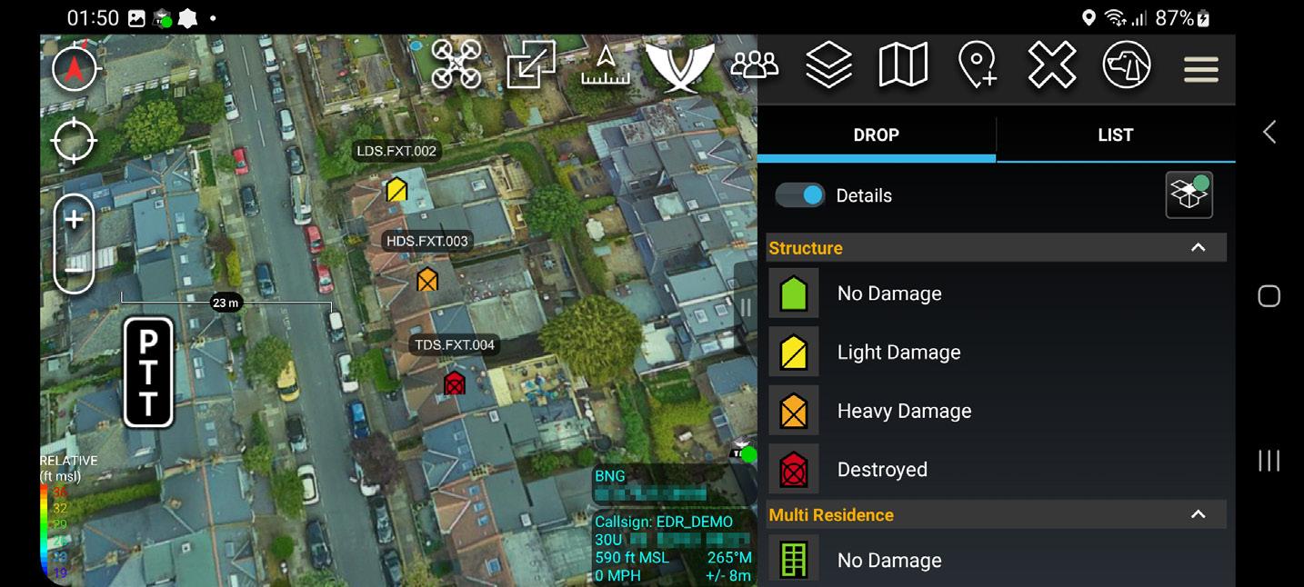
The WASP plugin has been used in a variety of real-world scenarios, including natural disasters, missing persons cases, and military operations. The plugin was used to locate a lost hiker in the mountains of Wyoming, who had been missing for four days. The search and rescue team used WASP to search a 30-square-mile area, and were able to locate the hiker using the plugin's grid search feature. After a disaster, it's important to assess the damage and track the progress of the response efforts. One way to do this is by using WASP feature for annotating and tracking markers that represent structures affected by the disaster. These markers can be used to track the progress of the recon primary and secondary search phases, and they can also be used to indicate the level of destruction and casualties using graphic symbols. Overall, the WASP plugin is a powerful tool for search and rescue operations, and adds significant value to the already impressive capabilities of the ATAK software suite.
Its ability to integrate with other modules and data sources makes it a versatile and adaptable solution for a wide range of scenarios.
Counter UAS: TAK can be used by CUAS teams to detect and track uncrewed aerial vehicles (UAVs) in restricted airspace. By using TAK, CUAS teams can coordinate their efforts and track multiple UAVs simultaneously, improving their ability to respond to potential threats. With the integration of mitigations, TAK can assist in the deconfliction of the airspace.
Final thoughts?
TAK is a powerful tool that can provide real-time situational awareness to police, fire, search and rescue, CUAS teams and other first responders. By improving communication, providing customisable map layers, and integrating with drones, TAK can help teams to make informed decisions and respond quickly to changing situations. As technology continues to advance, it is likely that TAK will continue to play an important role in emergency response and situational awareness for years to come.
If you would like to know more or arrange a live demonstration of TAK, please email info@aerial-defence.com


TAK, placing crucial information into the hands of emergency responders making critical decisions
About the Author
Steven Tisseyre Director and consultant at Aerial Defence Ltd

At the age of twenty-one, following my training and qualification as an electronics engineer, I chose to embark on a career in law enforcement. Driven by my natural curiosity and fascination with technology, I pursued a path that was centred on technology and investigation throughout my professional life in roles including Roads Policing and Major Crime.
In 2010, I designed and built my first drone and this personal interest culminated in my appointment as a National Police Advisor for Drones and C-UAS within Counter Terrorism Policing. From 2015 to 2021, I led several technical and highprofile investigative initiatives aimed at combating the malicious and criminal use of drones.
Having completed a successful 30-year career in the Police Service, I decided to channel my knowledge and experiences towards helping organisations in the field of drones and counter drones. To this end, I established a consultancy company specialising in providing drone and counterdrone related services and solutions to such organisations. This work has provided me with a unique opportunity to leverage my knowledge of drone technology and law enforcement to help safeguard critical infrastructure, prevent illegal activities, and ensure the safety of the public and my colleagues.
Contact Information
WEB: http://www.aerial-defence.com
Email: info@aerial-defence.com
