7 minute read
Flying high: Darryl Ashford-Smith


Providing Effective Training for Global Search and Rescue Teams: Insights from Darryl Ashford-Smith, Drone/Robotics Lead at Technical Rescue International.

Advertisement
Darryl, having previously served in USAR & ISAR in the London Fire Brigade, is currently a Mountain Rescue UAS Pilot in the Search & Rescue Aerial Association-Scotland, Scottish Mountain Rescue Training Support Officer and a Scottish Cave Rescue Organisation Training officer. Darryl is also the Drone/Robotics Lead for Technical Rescue International.
Technical Rescue International (TRI) specialises in the provision of technical rescue training and bespoke training packages for operations in high risk environments internationally. Drawing on their extensive experience with the Emergency Services, Military, Private Sector and Charitable Organisations both nationally and internationally, they work with clients to deliver practical risk based solutions tailored to their specific needs. actually use the drone in the respective
TRI is currently undergoing a range of research & development work (in partnership with the Edinburgh Drone Company) to establish how drones, or more aptly named robotics (drones for use in the air, on land, on or under water) can be used to enhance the outcomes of incidents involving technical rescue capabilities in real world environments and in particular, how they can be used to maintain first responder safety. TRI is driving to normalise the use of drones in technical rescue as opposed to a stand-alone team as for much of technical rescue work, the need is immediate and continuous.
TRI has noted that there is a current disconnect with many drone capabilities where organisations have drones, and can safely pilot them however, have no set formal or structured procedures on how to discipline to the greatest effect. For example, on what basis have you established your drone assessment or search procedures and have they been validated by proof of concept? Or do you just 'pop' the drone up for a look?
Technical Rescue International have recently undertaken a capacity building mission in Nepal to deliver a range of training events to a number of differing organisations, all of which involved the use of drones. The first was a Level 3 Swiftwater and Flood Rescue Course and was delivered to the Nepali Army, the second, a search & rescue drone course (rural & mountains) to the Himalayan Rescue Organisation and the third, an urban search & rescue (disaster incidents and collapsed structures) course delivered to the Nepal Police Disaster Office.

Swiftwater & Flood Rescue
Although the use of drones was not part of the course outcomes for this training event, TRI's Drone Instructors took the opportunity to further research and develop the use of small to medium size, commercial off-the-shelf (COTS) drones in a Swiftwater and flood environment. As you can imagine, if a Swiftwater & Flood Rescue Team have been deployed, then something has gone seriously wrong, either from a human perspective or from an environmental event. The types of incidents can range from being very dynamic and time critical to the aftermath of a flood with many casualties requiring locating and evacuating.
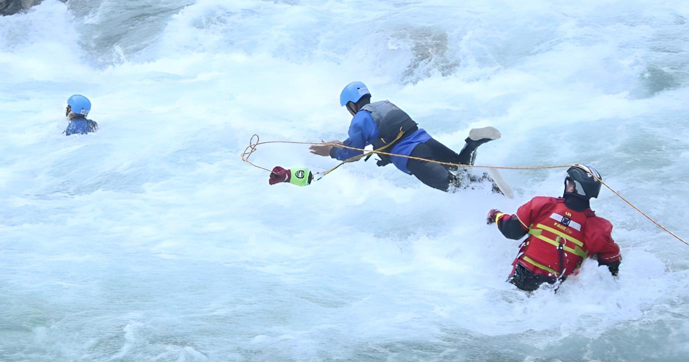
The drone needs to be with the team, it needs to be small, contained in a rugged and waterproof case (it may be carried for hours in the bottom of a rigid inflatable power boat) and ideally a platform that is weatherproof, has thermal image and zoom capabilities as a minimum.
It is obvious the drone will be used for search purposes and perhaps to mostly either search on banksides like in the image below for example or post flood assessment and search. Without the drone, a team may have to be committed in PPE (normally the last resort), in a boat, into moving water (again, way down the list of priorities in order of safety) to search the bank on slippery algae covered rocks and even then, responders may not be able to
Until a pilot is actually practising the specifics above, such as deploying the drone from a boat, on moving water, in the dark, they won't really get an appreciation of the difficulties which is why TRI are practising, developing and proving the concept in order to establish basic principles in each discipline.
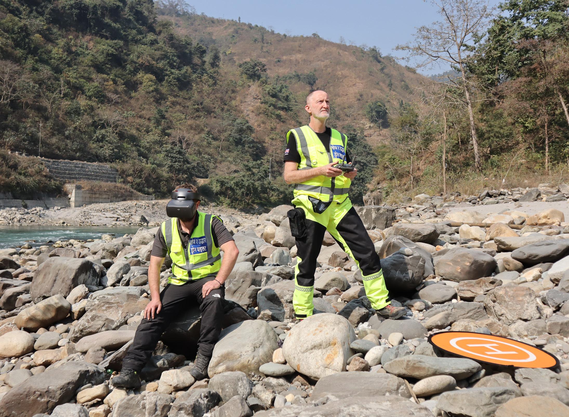
The Himalayan Rescue Organisation

The Himalayan Rescue Association Nepal (HRA) is a voluntary non-profit organization with an objective to reduce casualties in the Nepal Himalayas, especially keeping in view the increasing number of Nepalese and foreigners who trek up into the remote wilderness. The HRA Nepal facilitates the Medical Camp at Everest Base Camp with the aim of providing medical support to the climbers, support staff and visitors as well as promoting safety in the Himalayas. The drone training delivered involved familiarisation with the starting of a search & rescue drone capability, pilot skills and search and rescue theory and practise.
The most important thing that the HRA did was to introduce a capability however small. Some teams even now still deliberate whether to start a capability or not however, those that do not will have a difficult job trying to catch-up as they won't have the experience and background as technology moves on quickly. The course emphasised safety all the way through and getting the attendees to be process driven each time, every time by means of following a suite of checklists which didn't prove too difficult and was accepted readily.
Flying on search and rescue operations in mountainous environments has obvious difficulties, mostly relating to the weather, altitude and mountain features. The basic principles for each feature and each type of assessment or search task was covered as well as common terminology.
Attendees on the course included helicopter long-line specialists, mountain guides and rescue instructors. In addition to the training, the drone used for the delivery was also donated to the association and provided kindly by The Edinburgh Drone Company. The drone will be the first operational search & rescue drone located at Everest Base Camp. TRI continue to work with & support the HRA in bedding in and developing their drone capability.
The Nepal Police Disaster Management Division

Having already endured the Nepal earthquake in 2015 where approximately 9000 people were killed, many thousands injured and 600,000 structures damaged or destroyed in and around Kathmandu alone it can be seen that such an incident, as with the most recent example in Türkiye, is almost unthinkable to assess or manage.
One of the difficulties of such a disaster is making an effective assessment in order to direct the right resources to the right locations efficiently. If airports/ aerodromes/helipads are out of action or aircraft are unable to fly then making an assessment from the ground is extremely difficult and time consuming. In the image below of Kathmandu, it can be seen that structures are tightly packed together with narrow streets so to even make progress with a vehicle would be nigh on impossible.
Add the lack of buildings standards and other issues relating to safe structures, it is a foregone conclusion that should another earthquake happen, it will be an extremely difficult situation as it was in 2015.
In the image below at the 2015 earthquake, responders worked tirelessly for 3 days to secure a fallen clock tower hanging precariously over a hospital and causing it to close operating and treatment rooms which put even more pressure on already overwhelmed medical resources. To assess this type of damage did involve risk however, with a drone, that initial risk could have been almost completely removed.
It can be seen without doubt that incidents in ice fields such as on the Khumbu Glacier on one of Everests ascent routes would be extremely difficult to access and search on foot due to the complexity of the let alone the altitude. In addition, a new route may have to be laid to gain access to those in difficulty. To physically do this would obviously take a significant amount of time and effort however the use of a drone would prove invaluable in such conditions and save time.

Obviously drones will be useful however, with regards to the initial assessment, the area in these types of disaster is vast, small COTS drones would not be effective until it came down to assessing a worksite rather than the wide area. As technology develops and becomes less expensive, strategies will change.
Somewhere like Kathmandu which is still at great risk from another earthquake may benefit from a number of strategically located drones (rotor/fixed wing), in protective dock stations at earthquake safe locations that will deploy and fly a pre-set flight path in order to gather information that can be relayed to teams on the ground or on route.
This technology is here, it is now. The difficulty is getting this capability embedded in less developing countries where many difficulties stand in the way.
The training with the Nepal Police Disaster Management Division included familiarisation again, with starting a drone capability, pilot skills and search and rescue theory and practise but specific to wide area assessment, worksite assessment (both as defined by the International Search & Rescue Advisory Group) and the search of collapsed structures including the considerations and techniques for flying drones inside structures.
TRI have been researching and developing this area of work for some time and have created a set of robust, effective procedures which offer the best chance of success with regards to search but critically, enhancing responder safety.
TRI believes that drones could be more 'normalised' within the emergency services and integrated within technical rescue units, stations or key individuals. As technology develops, the platforms will become lighter with greater capabilities however, we do not envisage that it is too far in future that technical rescue appliances will have an airborne drone that is weatherproof, has thermal image, zoom, ability to tether to the appliance and also to attach devices such as gas monitors. info@technicalrescueinternational.co.uk
Other drones depending on the teams capability may include a waterborne drone for surface rescue and possibly a wheeled drone used for assessment/monitoring on the ground or unstable surfaces such as ice. TRI is currently researching and developing all of these aspects in the drive to encourage robotics to be standard on technical rescue units.
Darryl Ashford-Smith
Darryl, having previously served in USAR & ISAR in the London Fire Brigade, is currently a Mountain Rescue UAS Pilot in the Search & Rescue Aerial Association-Scotland, Scottish Mountain Rescue Training Support Officer and a Scottish Cave Rescue Organisation Training officer. Darryl is also the Drone/Robotics Lead for Technical Rescue International.
The DRONERESPONDERS Global Public Safety Drone Map Dashboard was a result of a partnership with NASA AMES Research Institute and ESRI. The Map Dashboard was designed to serve as a way to share Public Safety Drone Program information between agencies around the world. It has also been used to help facilitate regional mutual aid cooperation and regional training The Map Dashboard is open to all public safety agencies and is managed by former Pearland TX Police Officer Brandon Karr This also allows for filtering by state, discipline and more


Here's a 3 minute survey to add your organization's info: https://bit.Lu/2RHlwyj
Here is the Map Dashboard link to nearly 1300 already participating: https://droneresponders.maps.arcgis.com/apps/dashboards/5dd2710f19e24
703823789eb9c2a7b70


