4 minute read
Bribie was a ZOO without a fence in 1960 Bribie was a ZOO without a fence in 1960


More Bribie History
Historical Society monthly meetings are second Wednesday of each month at 6;30 pm at the RSL Club and visitors are always welcome. See more stories and photos of Bribie history on our Web Site Bribiehistoricalsociety.org.au and Blog Site http:// bribieislandhistory.blogspot.com or contact us on bribiehistoricalsociety@gmail.com
Advertisement
The title photo shows a group of wild horses wandering the foreshore on Welsby Parade in 1953, ten years before the Bribie Bridge was built. The residents of Bongaree grew steadily from 1912 and wild cattle and horses regularly roamed the streets, their droppings eagerly sought by housewives to burn for insect repellent. The “mozzies” were a huge problem back then, as the soldiers based here in World War 2 soon found out.
Building the Bribie Bridge led to the development of new suburbs at Bellara, Sylvan Beach and Banksia Beach. In 1963 the resident population of Bribie was just 700 people, and in the first 12 years when there was an expensive Toll to cross it, the population grew by only 300 people. This article provides an insight into Bribie in the 1960s and 70s when Estate Agents and Developers had great plans to transform the island and attract investors and new residents.
Before the bridge, Bribie was regarded as a “Zoo without a Fence” by pioneer residents and lovers of nature who came to see abundant wildflowers in season. One of these was Roy Sheppard who came to Bribie after a distinguished Naval career in Asia and was a Policeman in Brisbane and Adavale in 1963 when floods swept through. From 1969 he worked for APM plantations and Caboolture Council and developed a great appreciation for the island's flora and fauna. This hand-drawn Map by Roy Sheppard was given to me just before he died in 2007. Like me, he tried to document the unique history and people of Bribie and was a great observer of wildlife.
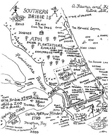
There is a lot to see on his interesting Map including a 600-acre site where Queensland University conducted research into radio wave transmission using an Atomic Clock for precise measurement. This was long before mobile phones had been invented when radio signals were bounced off the Ionosphere. The Manager of the facility was Ben Tesch who ran the first vehicle Ferry and built the recently demolished “Round House” in Banya Street. Nothing remains of the Qld. Uni. Research Centre which was in the bush behind where the Community Arts Centre stands today.
The Map shows various animals, birds and fish, freshwater lagoons on Ocean Beach, with extensive areas of trees and everglades, Dingo Creek, Wildflower Gardens, Boronia Heath, Mosquitoes and Emus. Roy had a great understanding of the bush and nature and explored all the bush tracks and beaches of Bribie and spent years protecting things that made this place so special.
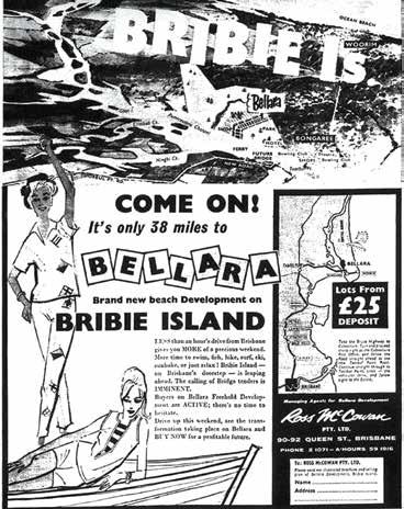
This is a 1960 newspaper advert by Ross McGowan, the Queen Street Brisbane Agent for Bellara Development when the Bridge to Bribie was first announced. It proudly promotes the attractions of Bellara being just 38 miles from Brisbane, accessible by vehicular ferry
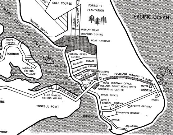
This Map shows various future Estates in 1965 with planned subdivision and development of several original farm properties north and south of the newly built Bridge. The Map shows a proposed 4-lane highway from proposed on Benabrow Avenue, and several large properties were to be subdivided and given the names Bribie Pines, Pumicestone Estate, Bellara Estate, Sylvan Beach Estate and Avoca Estate. The advert was for blocks of land in the Bellara Estate, the first to be developed. The new suburb of Bellara was built around a lake and swamp that is now bordered by Bibimulya Street. An open concrete-lined drain now runs from the Bibimulya lakes, under Sylvan Beach esplanade into the Passage. As you can see on the 1965 Map there was a plan back then to make it into a Boating Canal Estate. This did not happen, but many years later two large canal developments were dredged and constructed to run into the Passage both north and south of the Bridge. The map also indicates a Boat Harbour and Shopping Centre at what is now Pacific Harbour Marina, and a completely new suburb of Banksia Beach, which in those days was a long way away through the bush on rough dirt roads. as a new tourist attraction. It was not a great success and soon closed but you can still see remains of some concrete Fish Tanks in the bush at Red Beach if you know where to look. There were several planned Motels and Restaurants shown on the Map but no indication of the major Bribie Island Shopping Centre that was built much later. That happened after Benabrow Avenue was joined to Goodwin Drive and ran south to join First Avenue, where the new satellite Hospital is now being constructed. The proposed 4-lane highway from the Bridge to Woorim never did eventuate. We are now in public discussion about a second Bridge 60 years later. A close look at the Map reveals some other interesting bits of Bribie's development.
FREE Guided Heritage Walks
Explore BRIBIE ISLAND
HISTORY on a BONGAREE HERITAGE WALK
THU 9 MARCH & 4 MAY 2023 with brand new beach Lots for a 25-pound deposit. That was just $50 in the new decimal currency.
A Commercial Centre was
There was also an indication of a Golf Course in that area in 1965. It was built 40 years later in a different location and is now surrounded by thousands of new homes and canal developments known as Pacific Harbour.
An Aquarium is marked on the southern end of Bribie at Red Beach which was built in 1963
Appreciate the strategic importance of BRIBIE ISLAND IN WW2
THU 16 MARCH & 18 MAY 2023 suitable for participants 18 years and over. Easy walking - starts 9.30am for 90 mins
Experienced guides from the Bribie Historical Society BOOKINGS ESSENTIAL ON WEBSITE mbrc.qld.gov.au/healthy-active
Quick crossword no 16,475