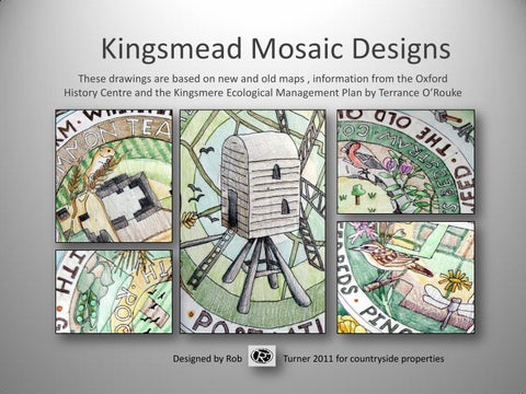
Kingsmead Mosaic Designs These drawings are based on new and old maps , information from the Oxford History Centre and the Kingsmere Ecological Management Plan by Terrance O’Rouke
Designed by Rob
Turner 2011 for countryside properties
Kingsmead shared space mosaic designs The mosaic designs have the lettering facing out so they can read from any position as people can approach them from any angle
There has been relatively little human activity on this site, so the focus has become about natural history and its relationship with the small amount of industrial development carried out here. The mosaics are designed to highlight indigenous wildlife present on the site and celebrate the habitat creation for future bio diversity delivered through this building development by Countryside Properties. All mosaics 1.2 x 1.2m.
The old field names and boundaries There are no records at all in Cowley History Centre, but Will Glanfield has recorded them from a conversation with the farmer working at Whitelands Farm.
I have shown peas and cereals which were grown on the farm at one point and Aberdeen Angus cattle which grazed on the farm. I have included many of the field names which were on the site in the text .
The Old Quarry
Evidence of a small limestone quarry is shown on old maps (with trees and grass growing as shown in my design).
This drawing shows the animals and plants likely to grow on this type of calcareous grassland
Looking Back in Time to1752 The design carefully records details from two old maps in the Cowley History Centre. One of those old maps show a house with eight windows and two long out buildings.
Highlighted is the strip of land called the Bigginhall Enclosure owned in 1752 by James Dashwood.
The only other relevant information indicated on the maps was the presence of a windmill and the labelling of the area as arable land
The old Windmill
the only mosaic designed to be viewed from one orientation An early post type wind mill is indicated on old maps. I have shown some mill stones and cereal production in the corners with meadow wildlife.
Woodland habitats and
Foxey Leys Copse This has been an important wooded feature on the site for a long time.
Text in this design mentions bird and bat boxes and shows other planting improvements planned for woodland species on the new development
Whitelands Farm
taken from a map drawn in 1922 Whitelands Farm a well established though relatively recent feature on the site has map records showing its increase in size from 1899 to 1923 .
I have chosen to highlight farmland birds and other species likely to have been found around the farm . I have shown the presence of ancient barrows found on the site
Pringle Brook and new habitat corridors Pingle Brook and other water features are very a important element providing biodiversity for the site. The design shows two lakes and other new habitat corridors integrated within the developments masterplan