1 minute read
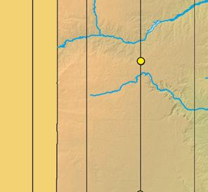
LAKE ALAN HENRY


SURFACE AREA: 2,880 acres
DEPTH: 100 feet
Advertisement
1993
ALAN HENRY IS ON THE DOUBLE Mountain Fork of the Brazos River.
Dominated by largemouth, it also has respectable spotted bass, catfish and crappie fishing.
This is a very narrow lake with a steep, rocky shoreline. Structure consists primarily of rock and timber.
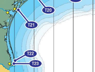
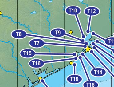
The following pages contain TIDE and SOLUNAR predictions for our Base Point, Galveston Channel (N 29.317, W 94.88)


Tidal movement and daily phases of the moon have varying degrees of influence on many fish and game species.
AM & PM MINOR phases occur when the moon rises and sets. These phases last 1 to 2 hours.
AM & PM MAJOR phases occur when the moon reaches its highest point overhead as well as when it is “underfoot” or at its highest point on the exact opposite side of the earth from your positoin (or literally under your feet). Most days have two Major Feeding Phases, each lasting about 2 hours.
PEAK TIMES: Our Forecast Calendar uses both Tide and SoLunar projections to predict the best fishing times and days. Generally, if a SoLunar Period (Major/Minor) falls within an hour of sunrise or sunset, fishing conditions should be better. On certain days where Tidal Activity is stronger, the best fishing times may fall ouside the normal SoLunar range. While tides are not a direct factor in FRESHWATER FISHING, SoLunar Activity still accounts for increased feeding activity in freshwater species. It is also a prime factor in the movement and feeding habits of game species.

Tide Conversion Table
TIDE PREDICTIONS are located in the White Area at the top of the Calendar Pages. You can use the CONVERSION TABLE below to make adjustments. It is keyed to 23 other tide stations along the Texas Coast (see these map icons: T1 ). Adjust low and high tide times, plus or minus in minutes, from the times given for the Base Point at Galveston Channel.


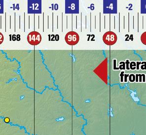


SOLUNAR ACTIVITY is shown in the Green Boxes on the Calendar pages. Moon Overhead and Underfoot times are given in the SoLunar Box and illustrated on the Fishing Graph. Use the SOLUNAR ADJUSTMENT SCALE on the map below to adjust times for points East and West of our Base Point at Galveston Channel.