4 minute read
Discover Our Heritage

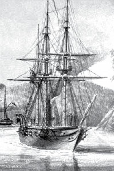
HMS Plumper and the first chart of Ladysmith Harbour
BY QUENTIN GOODBODY
The Oregon Treaty signed June 15, 1846, set the boundary between the United States and British North America in the Oregon Country – the land extending from the Rocky Mountains to the Pacific Ocean – as the 49th Parallel. It was agreed that the border, upon reaching the coast, would swing south of Vancouver Island.
However, ownership of the islands between Vancouver Island and the Mainland remained unsettled. A Boundary Commission was established in 1856, with Captain James Prevost (after which Mount Prevost, north of Duncan, is named) appointed British Commissioner in 1857. It became apparent that the existing marine surveys were not good enough to use as a basis for a boundary settlement in that area.

To deal with this issue, the British Admiralty in 1857 sent Captain George Henry Richards with the survey ship HMS Plumper to Vancouver Island with the following orders:
“... you will lose no time in setting out an accurate nautical survey of such portions of the channels and islands which lie between Vancouver Island and the Continent of America ...”
His orders continued:
“As soon as the work connected with the Boundary Commission shall be completed and Captain Prevost shall have no longer occasion for your services, you will proceed with the survey of the Gulf of Georgia and the harbours of Vancouver Island according to their importance. ... You will not fail to send tracings of all surveys and places and copies of all descriptions and Sailing Directions in order that when expedient they may immediately be communicated to Lloyds and made public for the benefit of sailors in general.”
Richards and HMS Plumper arrived in Esquimalt on November 10, 1857, and proceeded to chart the area of the San Juan Islands. Initial charting of the area was completed in June 1858, after which attention was turned to other places.
In 1859, a war nearly broke out between the US and Britain after an American settler shot a pig belonging to a British settler on San Juan Island. The conflict was largely averted thanks to the diplomacy of Captain Richards and Captain De Courcy of HMS Pylades. (The DeCourcy Group, DeCourcy Island and Pylades Island were later named after them.) The dispute was finally settled in 1872 by the Prussian Kaiser, who acted as an independent arbitrator and established the boundary through Haro Strait, where it remains today.
Having turned his attention away from the San Juan Islands, Richards charted the Ladysmith Harbour area in 1859. He named the harbour Oyster Harbour on account of the number of native oyster beds present. Later, it was renamed Ladysmith harbour.
Not only is the chart a work of art, but it is also remarkably accurate, attesting to the skill of the surveying crew, who worked from a fleet of up to seven small boats and used the anchored Plumper as their operational base. The chart predates the construction of the E&N Railway (1886) and the Town of Ladysmith (founded 1898–1900), so these features are absent.
This chart, a copy of which is available at the Ladysmith Museum to view, is one of many produced by Richards and his crew during his years on station here, 1857–1863.
Many of the coastal landmarks we know today were named by him, including features named after the ships company: Campbell River (after Dr. Samuel Campbell, ship’s surgeon), Pender Island (after Daniel Pender, master), Mayne Island (after Richard Mayne, second-lieutenant), Brockton Point (after Francis Brockton, ship’s engineer) and Mudge Island (after William Mudge, ship’s officer).
The Plumper was launched at Plymouth Dockyard on April 5, 1848. She was 484 tons (577 ton displacement), wooden hulled, 140 feet long, with a 27-foot-10-inch beam and a mean draught of 11 feet 4 inches. She carried a crew of about 100. Powered primarily by a two-cylinder vertical single-expansion steam engine (148 hp) driving a single screw, she was also barquerigged for sail. She was armed with two long 32-pounder cannon and ten short cannon. Her maximum speed was 7.5 knots. Because the screw slowed the ship under sail, it could be removed and stored on deck.
Plumper was replaced for survey duties in these waters in December 1860 by the more powerful and larger HMS Hecate, because she lacked the steam power required to navigate the commonly eight-plus knot tidal currents around northern Vancouver Island. She returned to England under the captaincy of Commander Anthony Hoskins, who had brought the Hecate out from England to replace her, and was paid off in July 1861 and sold for breaking in June 1865.