PORTFOLIO
SYNN SUNG HO Selected Works
01 THE MINIMUM REQUIREMENTS FOR PUBLIC SPACE
Cornell Architecture 2024 Spring Independent Studio CURATED DESIGN PROJECTS SUPPLEMENTS
05 RESEARCH EXPERIENCES Curated Research Projects
06 EXHIBITION
Coffee Ending UAUS (Union of Architecture University Students) Pavilion Festival 2016 Grand Prize, Mayor of Seoul Award
17 PROFESSIONAL WORKS JUNGLIM Architecture
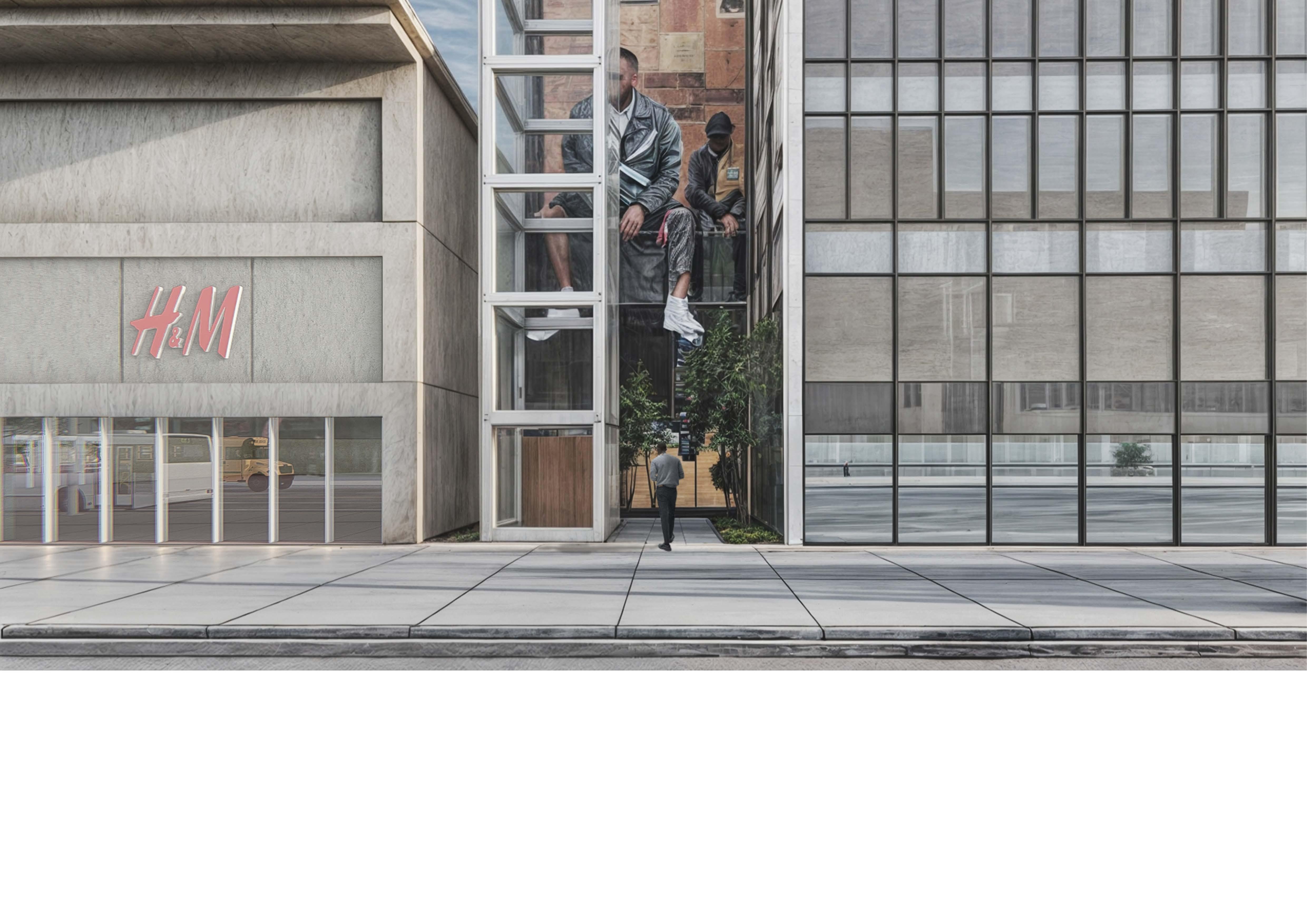
Law Amendment & Design Proposal for Privately Owned Public Spaces in Newyork City
The Zoning Code sets the minimum standards developers must meet, leaving the creation of enhanced, user-friendly POPS to private entities rather than national authorities. Consequently, urban improvement may stem from clusters of buildings meeting only minimum requirements rather than aiming beyond them. Current POPS regulations impose overly specific and generalized design guidelines, limiting the potential for private entities to improve design quality. These rigid guidelines may hinder the installation of new POPS and restrict innovative designs. Simplifying and increasing the flexibility of regulations is essential to encourage diverse design approaches.
Moreover, current regulations lack mechanisms for public participation in POPS design, leading to spaces that may not reflect site context or public needs, risking neglect. While public input is part of the NYC City Planning Department's ULURP process, its length deters private entities from including POPS. A new, streamlined process for public involvement in POPS design is needed. To promote active use of POPS, a governance system allowing citizens to lease these spaces, akin to renting public parks, is recommended, along with the development of supportive systems.
Current Status of Privately Owned Public Spaces (POPS) in NYC
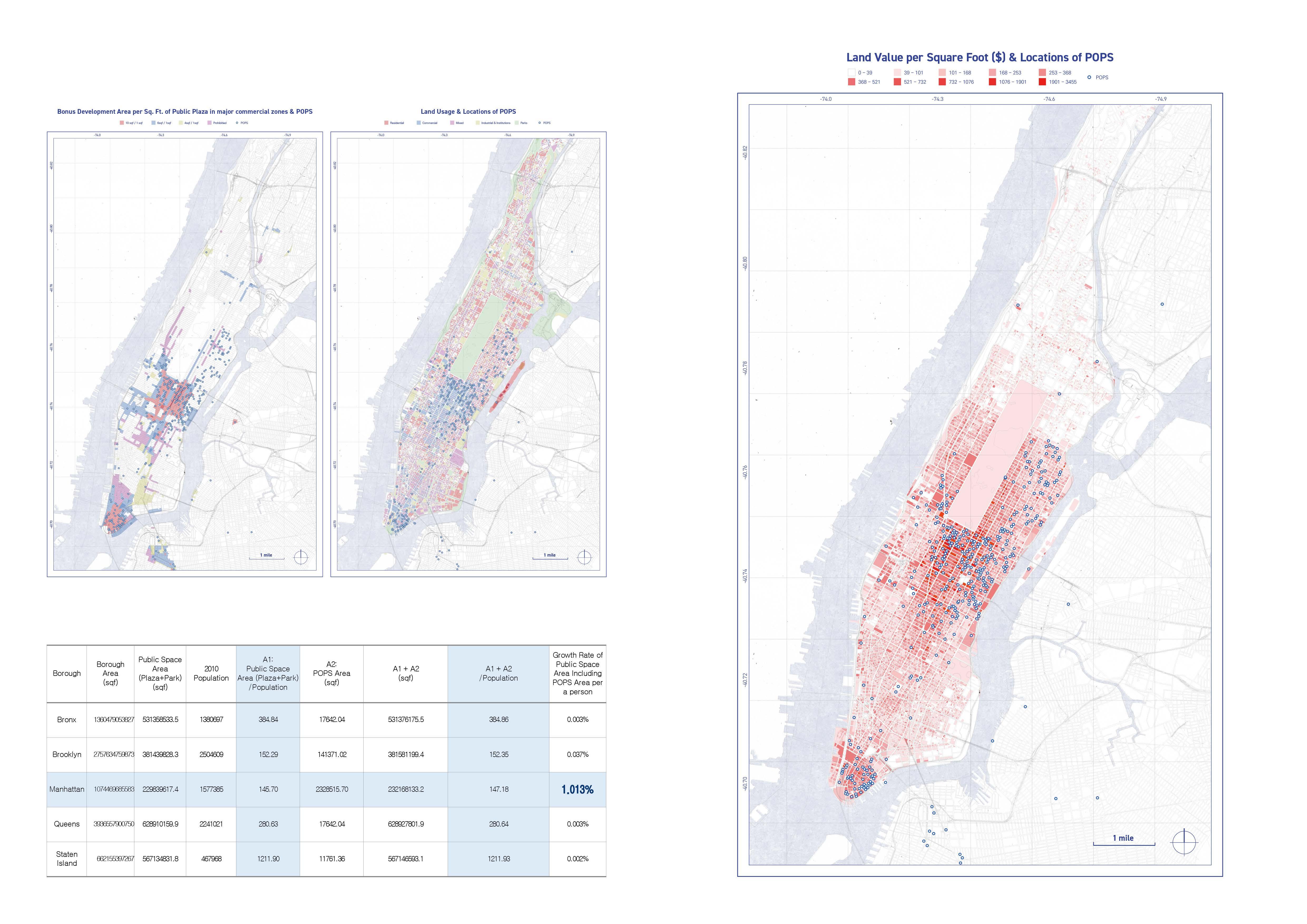
POPS, introduced in 1961, have evolved based on zoning laws, resulting in their uneven distribution due to developer-driven, free-market dynamics. These spaces are concentrated in high-value commercial areas like Midtown Manhattan, while northern Manhattan and the Bronx see sparse installations. The pattern highlights the need for policy changes to promote a more equitable distribution of POPS.
Impact of POPS on Expanding Public Space
Analyzing public space per capita reveals that excluding POPS reduces Manhattan's public space by 1%, emphasizing their significant contribution to urban public spaces. This highlights the role of POPS in expanding amenities and improving urban life in dense areas. The findings underscore their importance in high-density environments like Manhattan.
Inequality in Public Space Accessibility
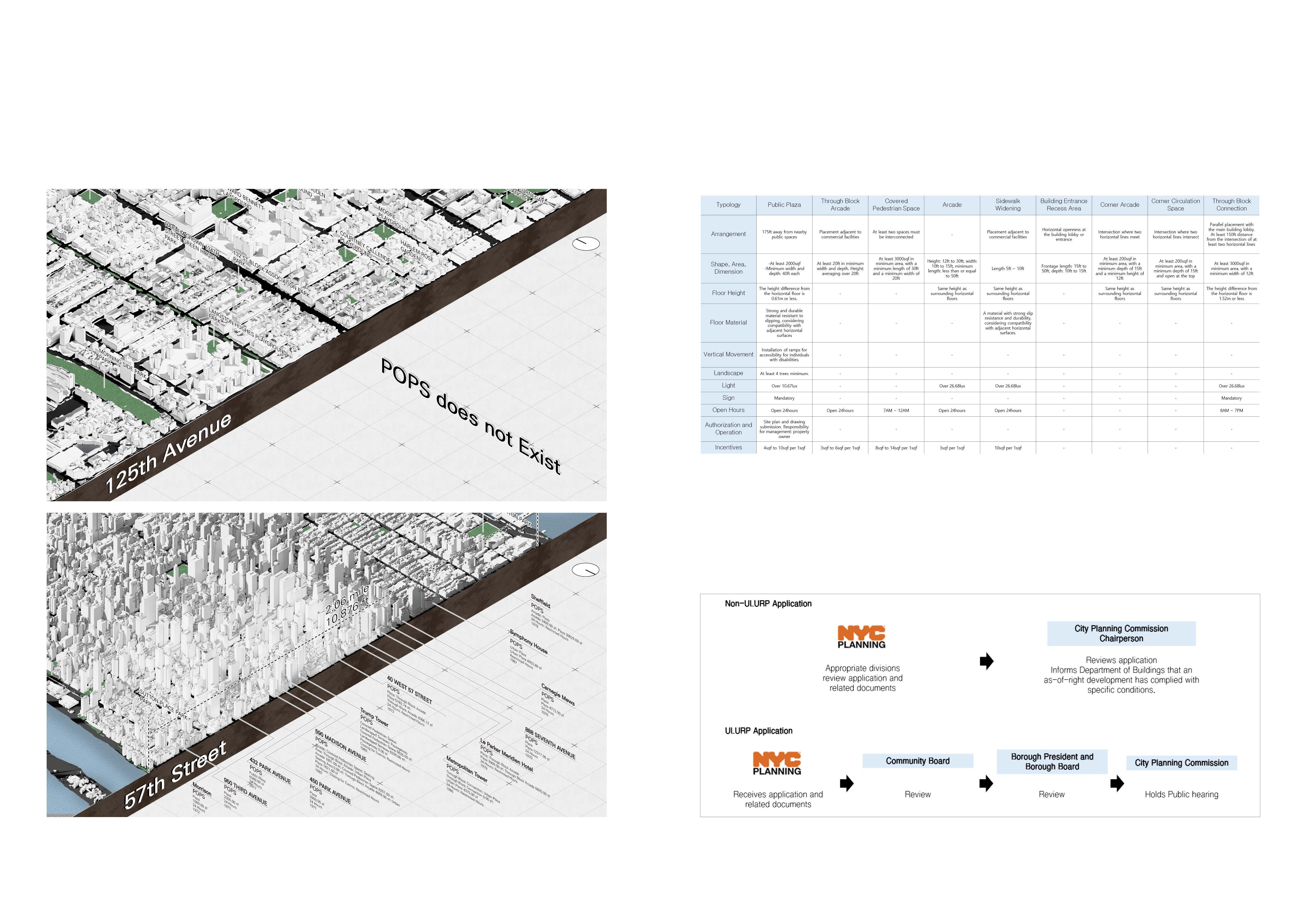
In commercial districts like 57th Street, pedestrians encounter public spaces frequently as they walk along the streets. However, in areas such as near 125th Avenue, Harlem, where there is currently a shortage of park space per capita, the installation rate of Privately Owned Public Spaces (POPS) is relatively low. This disparity in accessibility to public spaces highlights a significant inequality in the provision of public amenities.
Design Constraints and Standardization Issues in POPS Development
When analyzing the design standards for each type of Privately Owned Public Space (POPS), it becomes clear that there is significant diversity with considerable variation in detail. Specifically, the dimensions lack standardization, and regulations related to incentives differ, which may impose substantial constraints on architects' design approaches. Particularly, the design standards for plazas are highly detailed, potentially restricting the autonomy of architects and developers. This often results in numerous generic designs for POPS, limiting their uniqueness and effectiveness in serving the public.
Challenges in POPS Approval: Limited Public Input and Inefficiencies
The permitting and management of Privately Owned Public Spaces (POPS) are administered by the Department of City Planning in New York City. This department reviews all POPS applications to ensure compliance with established standards and maintains relevant data and drawings.
The approval process is divided into Non-ULURP and ULURP categories. ULURP, or Uniform Land Use Review Process, mandates public participation and applies to significant modifications like zoning changes. Most POPS outside Special Planning Districts follow the Non-ULURP process, which does not require public input, resulting in limited meaningful reviews. Although ULURP ensures thorough review, it is a lengthy process requiring City Council approval.
Proposed Regulatory Reforms to Enhance POPS Implementation and Design Flexibility
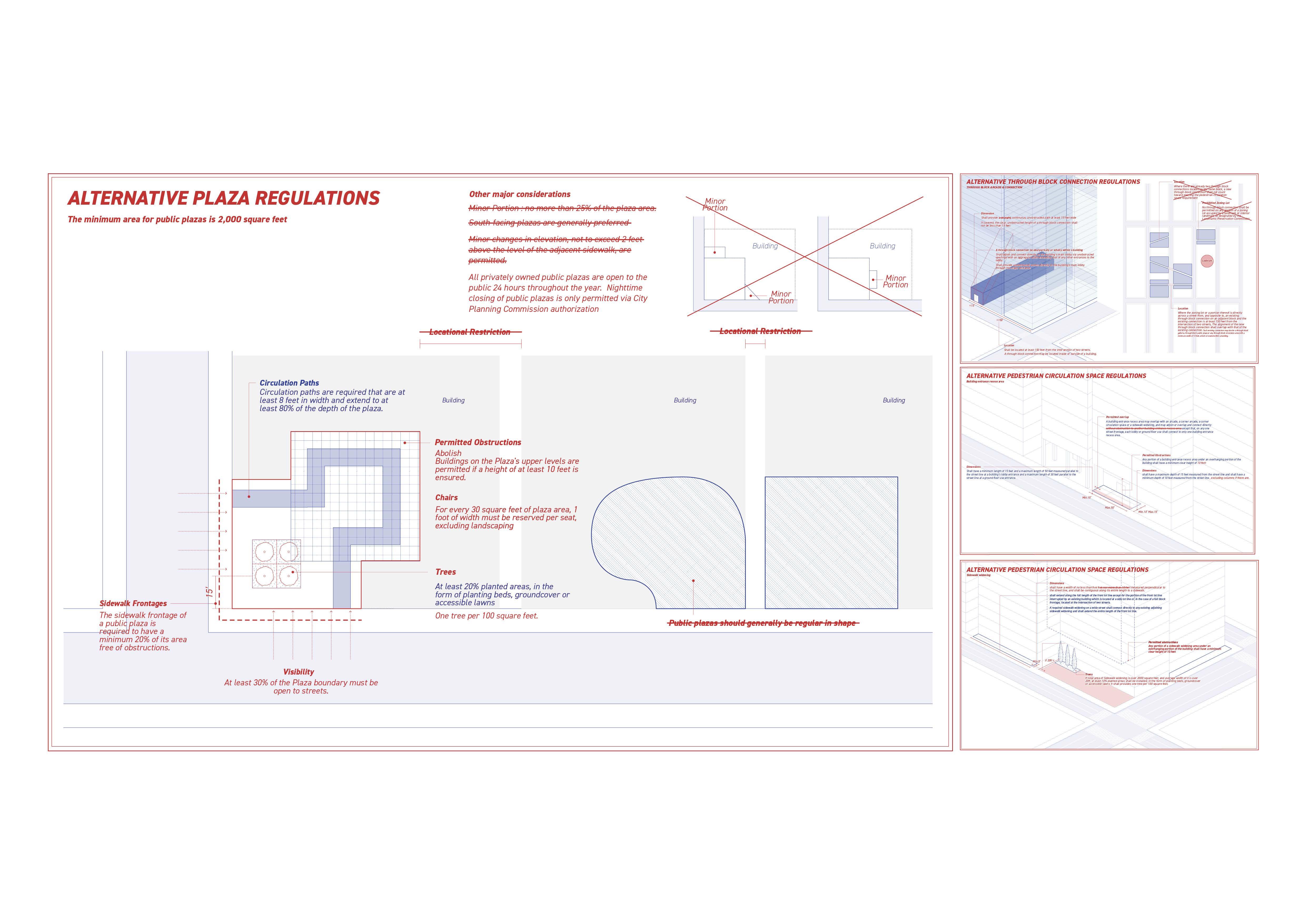
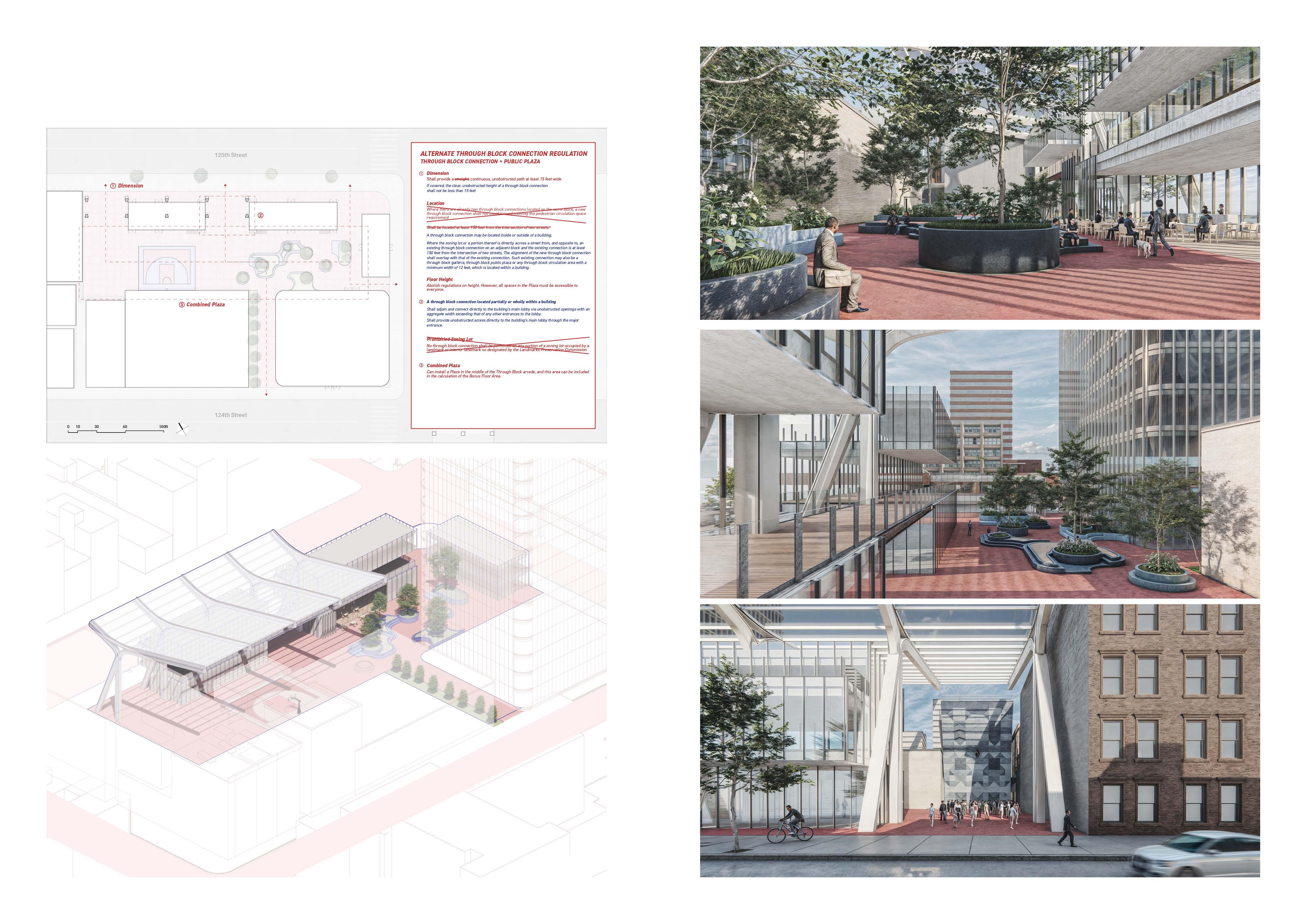
The proposed alternative regulation should abrogate existing laws that inhibit the implementation of POPS, thereby providing building developers with extensive opportunities to integrate POPS into their projects. Furthermore, the physical design regulations should be revised to harmonize the excessively diverse numerical requirements across different POPS categories, offering ample figures that facilitate design flexibility. Moreover, it should allow for the simultaneous installation of multiple POPS categories and permit the inclusion of POPS on rooftops. These regulatory modifications will enable building developers to more readily acquire bonus floor area through the installation of POPS, thereby alleviating the stringent design constraints and mitigating the psychological and temporal burdens associated with securing governmental approval for their designs.
Streamlining POPS Categories: A Proposal for Simplified and Unified Regulations
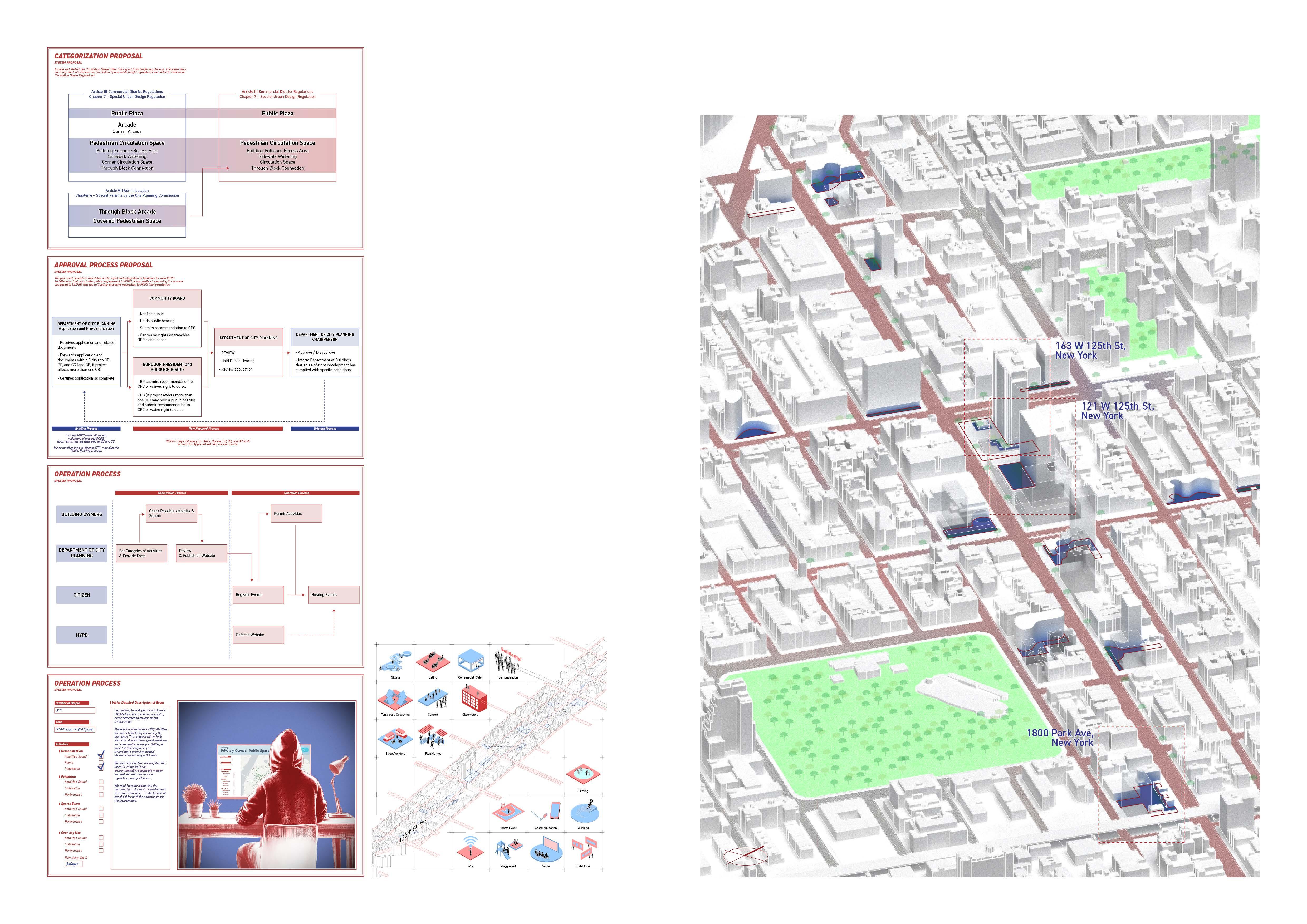
From my analysis, it is apparent that there are an excessive number of POPS categories, with the regulations for Arcades and Pedestrian Circulation Spaces showing negligible differences. To mitigate overregulation, I propose consolidating these categories and introducing height-specific regulations.
Furthermore, I have standardized the regulations for Through Block Arcades and Covered Pedestrian Spaces, previously considered special cases, under the general Through Block Connections regulations. This reclassification aims to streamline POPS management and reduce psychological barriers for stakeholders.
Enhancing POPS Approval and Management Through Public Review and Online Systems
For the approval process, although not identical to ULURP, all POPS will undergo review by the City Planning Department, Community Board, or Borough Board, ensuring incorporation of feedback from these public entities.
I suggest that the Department of City Planning receive activity details for approval from building owners regarding permitted activities in POPS. These details would be registered in an online system, enabling citizens to select and book POPS online. Additionally, I propose a system where, if any illegal activities are detected during these events, the NYPD would intervene. For instance, citizens could enter the desired time, location, and number of participants for using a POPS online, and then obtain permission from the building owners through the system.
125th Street, Harlem: Selected as a Testbed for Future POPS
The site is situated on 125th Street in Harlem, designated as a commercial district in northern Manhattan. Despite this designation, the area lacks installed Privately Owned Public Spaces (POPS) and remains underdeveloped. Consequently, it is considered an optimal location for envisioning and planning future development scenarios, offering significant potential for urban enhancement and revitalization.
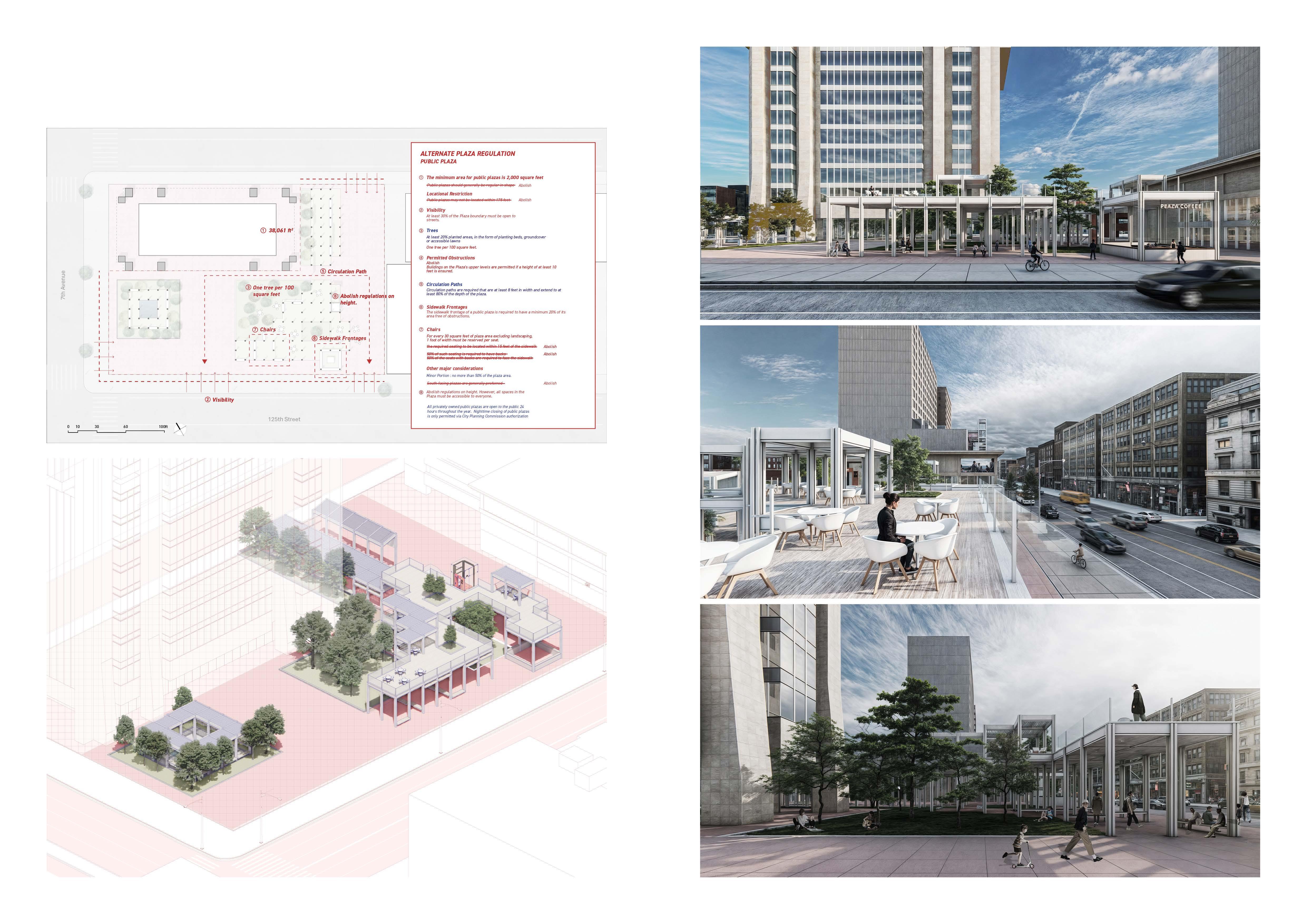
163 W 125th St, New York ; Plaza
The site at 163W 125th Street, currently occupied by the New York State Office Building, includes a large but underutilized plaza lacking clear purpose. propose transforming this space into a new POPS with a pavilion to enhance its appeal and functionality. By revising visibility regulations and allowing Plazas above ground level with adjusted floor heights, a two-story plaza has been designed to better utilize vertical space. These changes aim to create a vibrant and purposeful public amenity, contributing to urban revitalization efforts.
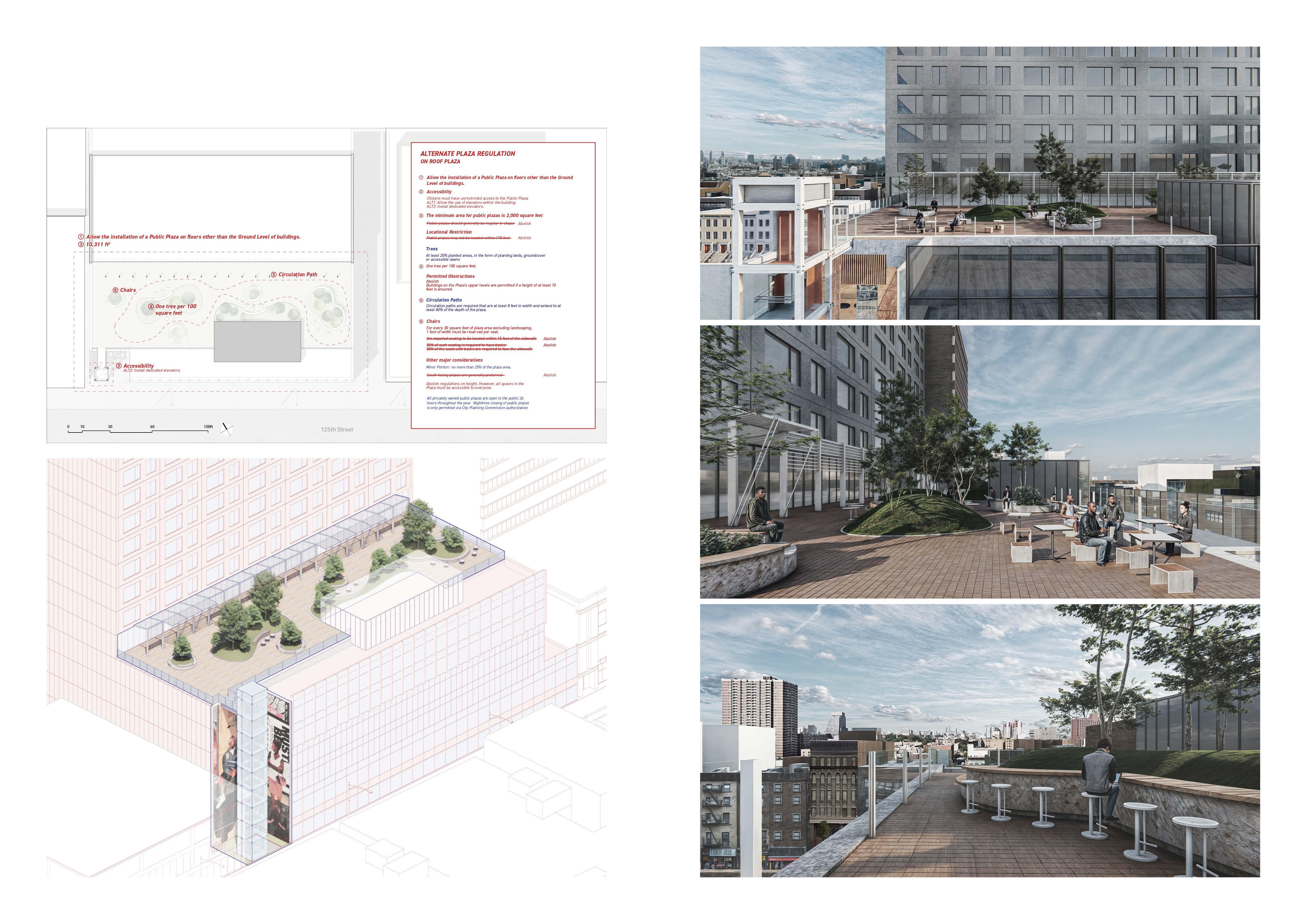
121 W 125th St, New York; On Roof Plaza
The building at 121 W 125th St, New York, currently lacks any POPS. This proposal recommends repurposing part of the building to create a rooftop plaza. By revising regulations to remove the minimum size requirement for plazas, public spaces can be developed even in smaller rooftop areas. Furthermore, updated accessibility guidelines will ensure convenient access to the rooftop plaza.
1800 Park Ave, New York; Through Block Connection, Plaza
1800 Park Ave, New York, is a vacant lot with considerable potential for large-scale development. This proposal envisions a new type of POPS that integrates a Through Block Connection with a Plaza. By modifying regulations to allow non-linear layouts, the design can facilitate multiple access points through the block. Additionally, updating the rules to permit POPS that are not entirely visible from the outside would create a serene environment, providing a welcome escape from the city's hustle and bustle.
THE ROAD
Yonsei Architecture 2-2 Project
Year: 2014
Location: Seoul, Republic of Korea
Type Museum, Community Center
Category Individual Academic Work
The road is an essential element of urban life, providing not only a means of transportation but also leaving behind traces of the lives of the people who use it.
In this project, "The Road," the focus is on the abstract traces of the city's past, which are revealed on the site’s surface and used to inform the new program. The insertion of new programs and movements into the persisting urban context allows for architectural results that do not contradict the real lives of citizens. PHYSICAL
The community center, located along the road, provides various activities for people walking down the street, including art museums, a library, and an education center. As a result, the road that was once simply a means of transportation becomes a lively street where people can appreciate and experience art.
Community Center following the traces of the past for the future
Instructor: Youm Sang Hoon, Yun Oong Won
A Purposeless Bustling Street; Shortcut in the City
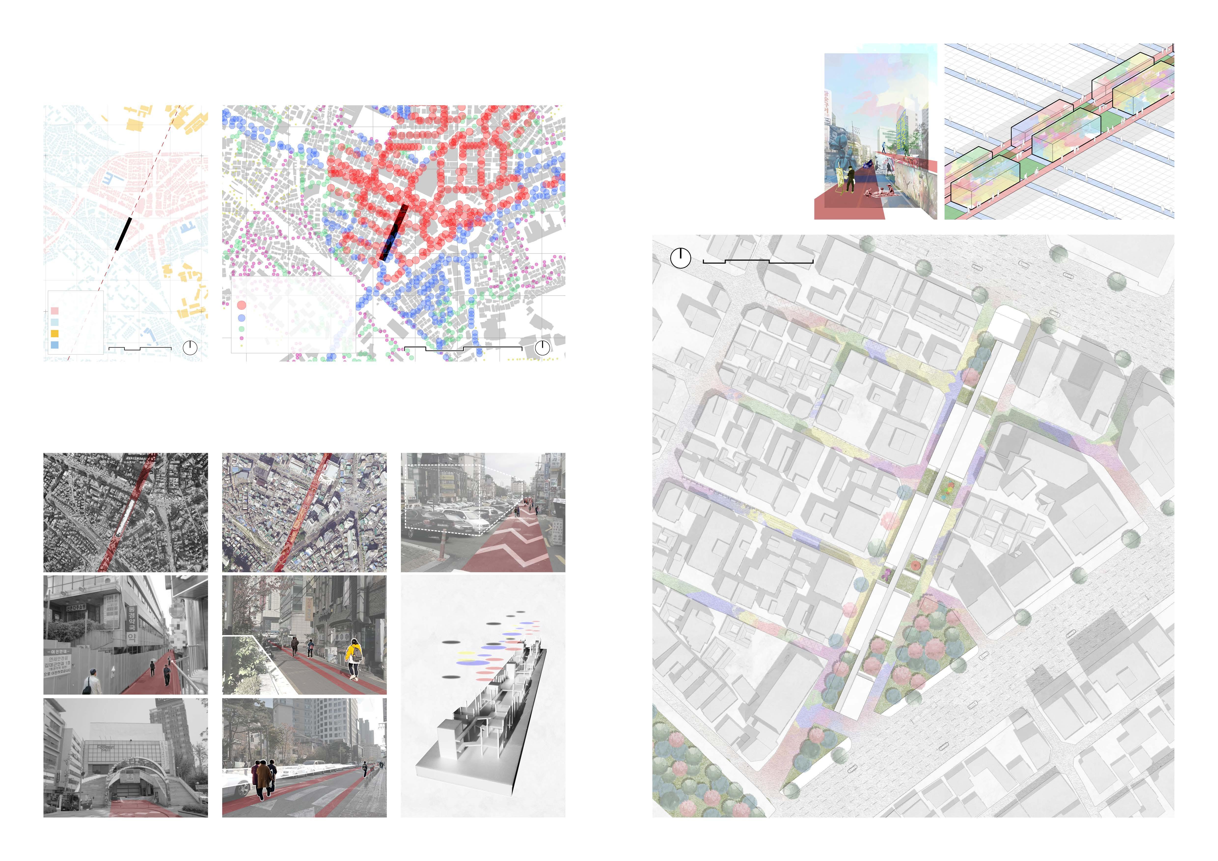
The site of this project is located in a residential area near the bustling streets of Sinchon in Seoul. Although there are few commercial facilities in this area, according to the analysis of pedestrian traffic, this site is the most frequented place in the vicinity. In other words, despite being in close proximity to the busiest area in Seoul, it has a unique role as a shortcut used by residents in the southern residential area to quickly access the bustling northern streets.
Reflection of Behavioral Context of Urban Street
In the past, there was a local market on the site. Its location and linear characteristics made it a natural gathering place for citizens. Despite the market's disappearance due to changes in urban development, the strength of the site's solid linear structure remains, providing a shortcut for citizens in the city.
Insert New Walking Experience
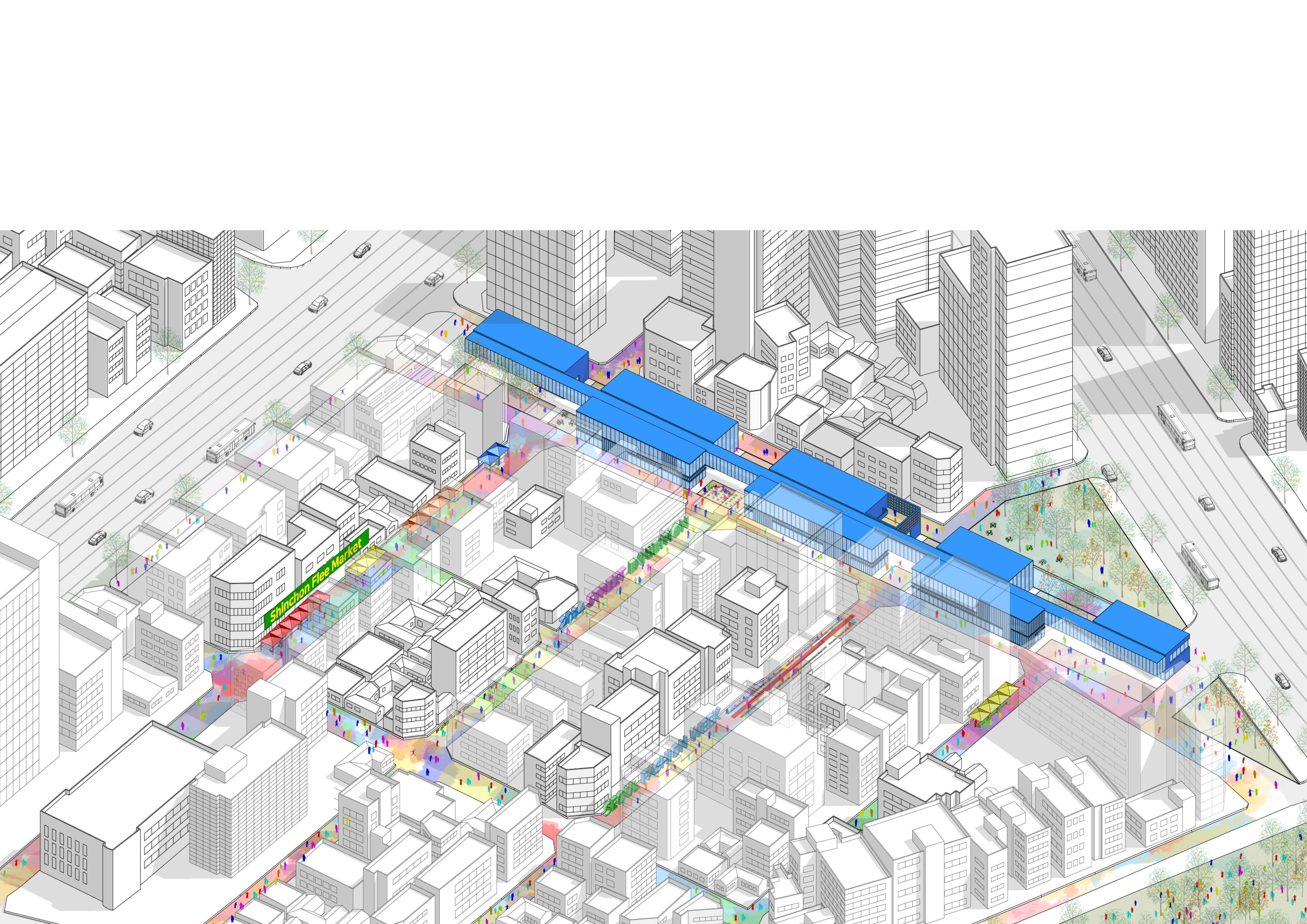
The art programs in the area provide a refreshing and enriching experience for those simply walking through the area. People can take different routes each day and encounter various art galleries and community programs centered around art.
The influence of these art programs extends beyond the walls of the buildings and onto the streets, bringing energy and vitality to the cultural atmosphere of Shinchon as it infiltrates the alleyways.
Site Plan; New Pedestrian Environment and Space Connected with Cities and Society
The center is divided into exhibition halls in the east and community centers with art content in the west, considering the main entry route for many people and residential areas. The open space between the buildings plays a crucial role in connecting the programs inside the
to
and people’s lives.
2011. People walked through market
People still walk following trace Remaining Behaviors
3D Dimensional Behavioral Study Model
Plan ; The Continuity of Programs created by the Street
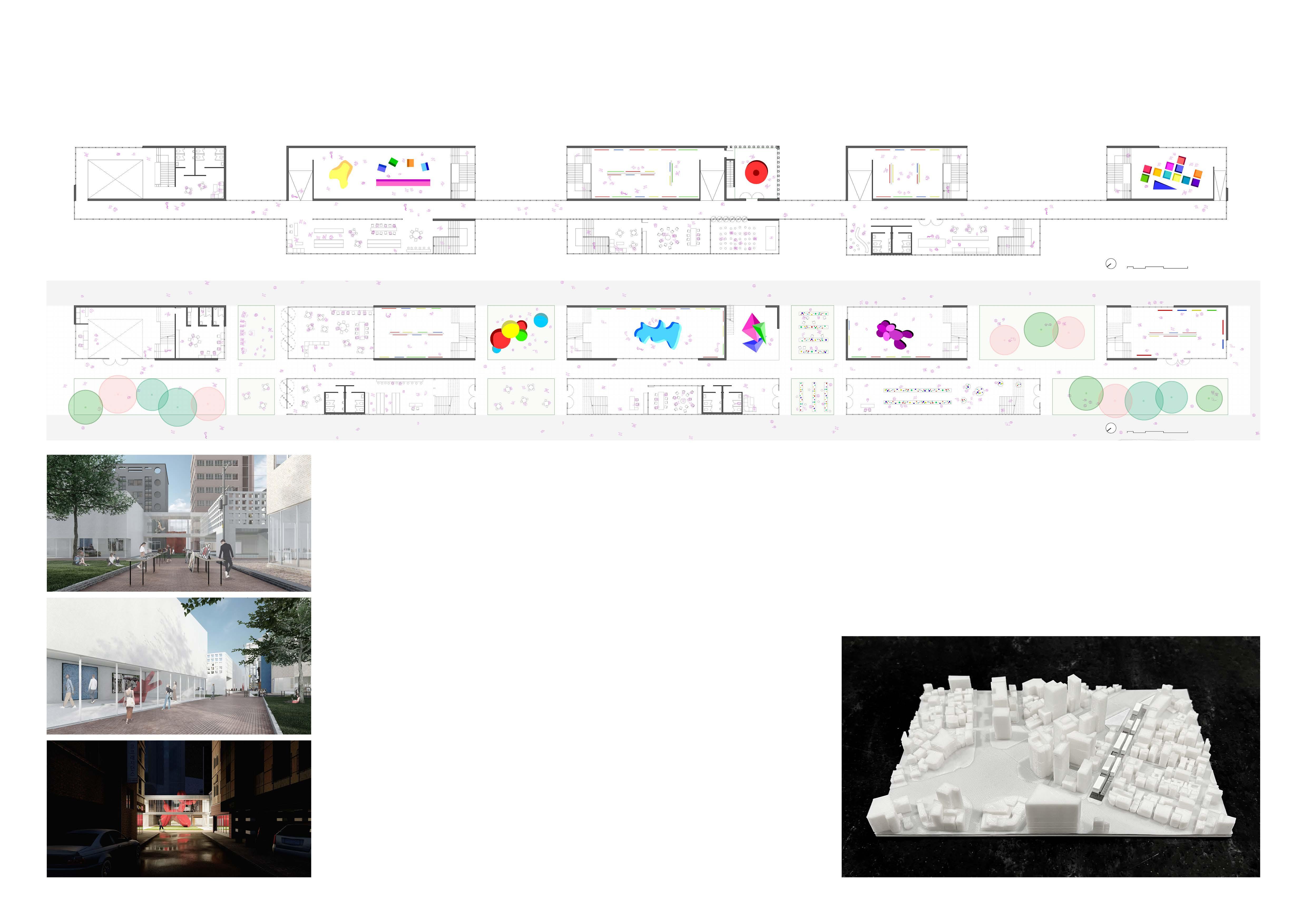
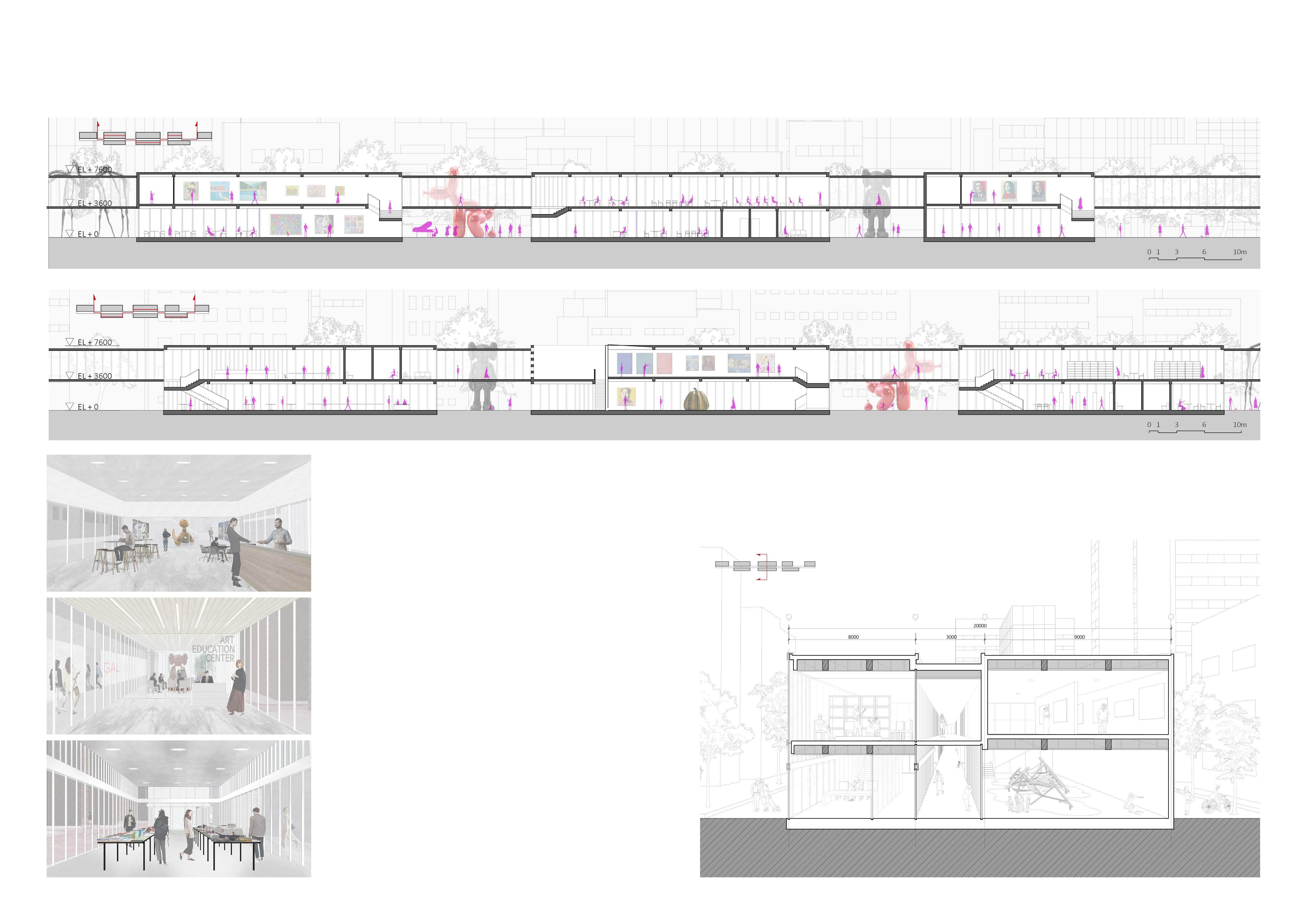
The five exhibition buildings and three community center buildings are around the corridor, serving as an indoor street. The synergy between the community centers and exhibition halls helps to energize the entire area. The corridor allows people to walk on the roads and continuously experience various programs.
Gardens
The gardens between the buildings feature different programs depending on the adjacent buildings. For instance, the garden between the craft studio and the art education center may be used as a market for showcasing works by local citizens and selling items made in the craft studio.
Exhibition for Pedestrians
The Exhibition Hall is partially open to the outside through its glass facade, allowing people who are walking on the street to enjoy the exhibition. This creates motivation for them to participate in other community programs voluntarily.
The second-floor corridor extends across the entire site and illuminates the alley at night, creating a vibrant atmosphere in the underdeveloped and poorly secured old town of Shinchon.
1:2000 Scale Model; Revitalized Axis
Light House of Alley
Open
Various
Section; Sequence of Community and Museum
The lifted corridor and shortcut on the first floor connect galleries and various programs, providing a continuous flow of space and program experiences for users.
Museum Cafe
Cafes within the exhibition hall allow visitors to enjoy the views of the galleries while sipping on their drinks. These cafes also provide a space for outdoor performances and other community events, creating a unique and vibrant atmosphere for residents of Seoul.
The Art Education Center is connected to the exhibition hall to offer highquality public art education. Additionally, its facade is open to the corridor and outdoor areas, encouraging citizens to participate.
Museum Shop, Craft Studio
The museum shop, located on the first floor, sells commercial products and supports emerging artists in connection with the craft studio on the upper floor. It also provides exhibition space for new artists in conjunction with Gallery 3 and 4.
Art Education Center
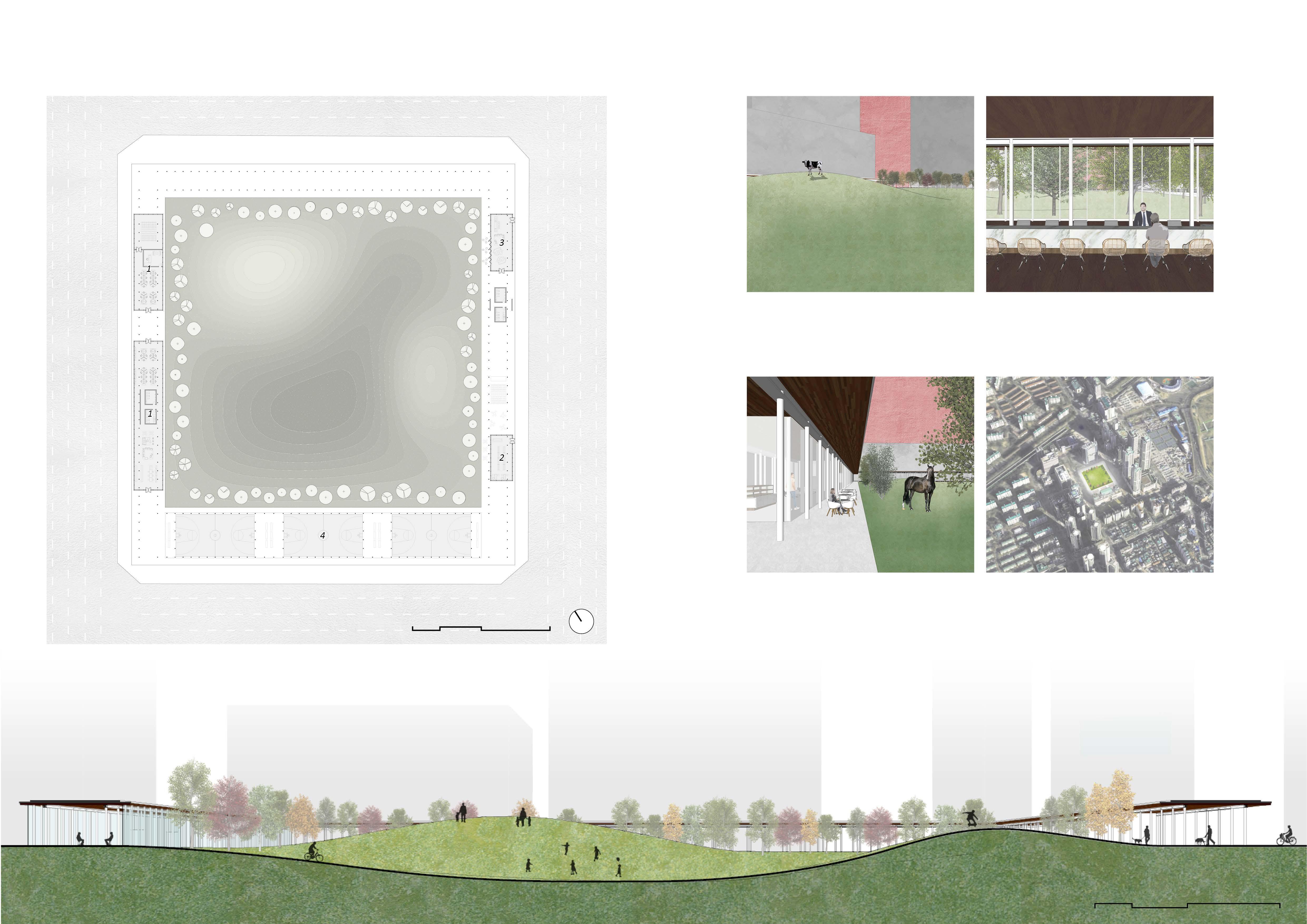
PARK OF VACANCY
Yonsei Architecture Graduation Project
Year: 2017
Location: Seoul, Republic of Korea
Type Theoretical Study, Park, Local Welfare Office
Category Individual Academic Work
PHYSICAL URBAN PUBLIC SPACE
Instructor Yun Seung Hyun
Redesigning Urban Open Space in Old Town
Cities have evolved over time to reflect the changing needs of society. As the modern era arrived, many architects proposed their ideas for the ideal city, and some of them have been put into practice.
South Korea's cities experienced rapid modernization and economic growth following the devastation of the Japanese colonial period and the 1950s war. During this process, urban planners and architects in Seoul implemented foreign urban planning theories without hesitation.
In recent years, Seoul has been undergoing a process of urban regeneration and reconstruction. This presents an opportunity for architects in the city to reconsider the foreign urban planning theories that have been applied throughout the city and to consider the changing needs of society and the unique characteristics of the local area in their work.
This project focuses on a park in a new town in Seoul that was built in the 1980s. It reconsiders the significance of public space, examining current trends and considering how urban parks can reflect society's changing needs and the region's unique characteristics. The project proposes new values for the park and is also a personal reflection and suggestion of me, who used to live in the area.
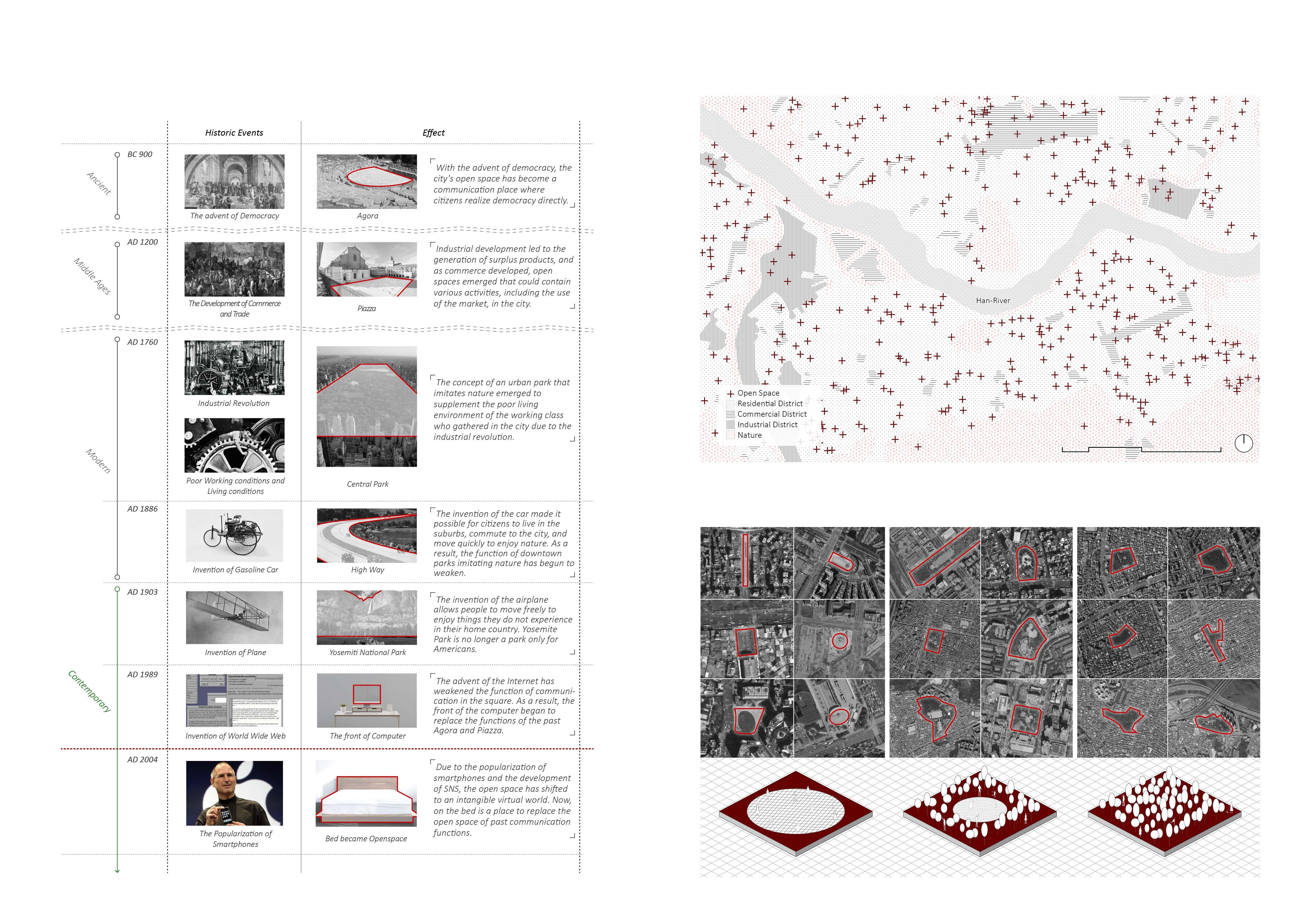
History of Open Spaces
In the modern era, the concept of open space has evolved. While it was once physically open to fulfill the needs of society, advances in technology have made its definition less clear and abstract. As a result, the role of urban open spaces as places for communication and relaxation must be reconsidered in the contemporary era.
Focus: Various Contexts of Seoul
For more than 2,000 years, Seoul has become a metropolitan with diverse contexts through devastation, restoration, and development. Therefore, open spaces throughout Seoul rarely have common needs, and each is unique.
Similar Types Of Urban Open Space In Seoul
Almost all types of urban open spaces in Seoul are consistent with the following three types. These spaces lack a connection to people's needs and interests, making them unappealing and uninviting.
Urban Structure and Characteristics
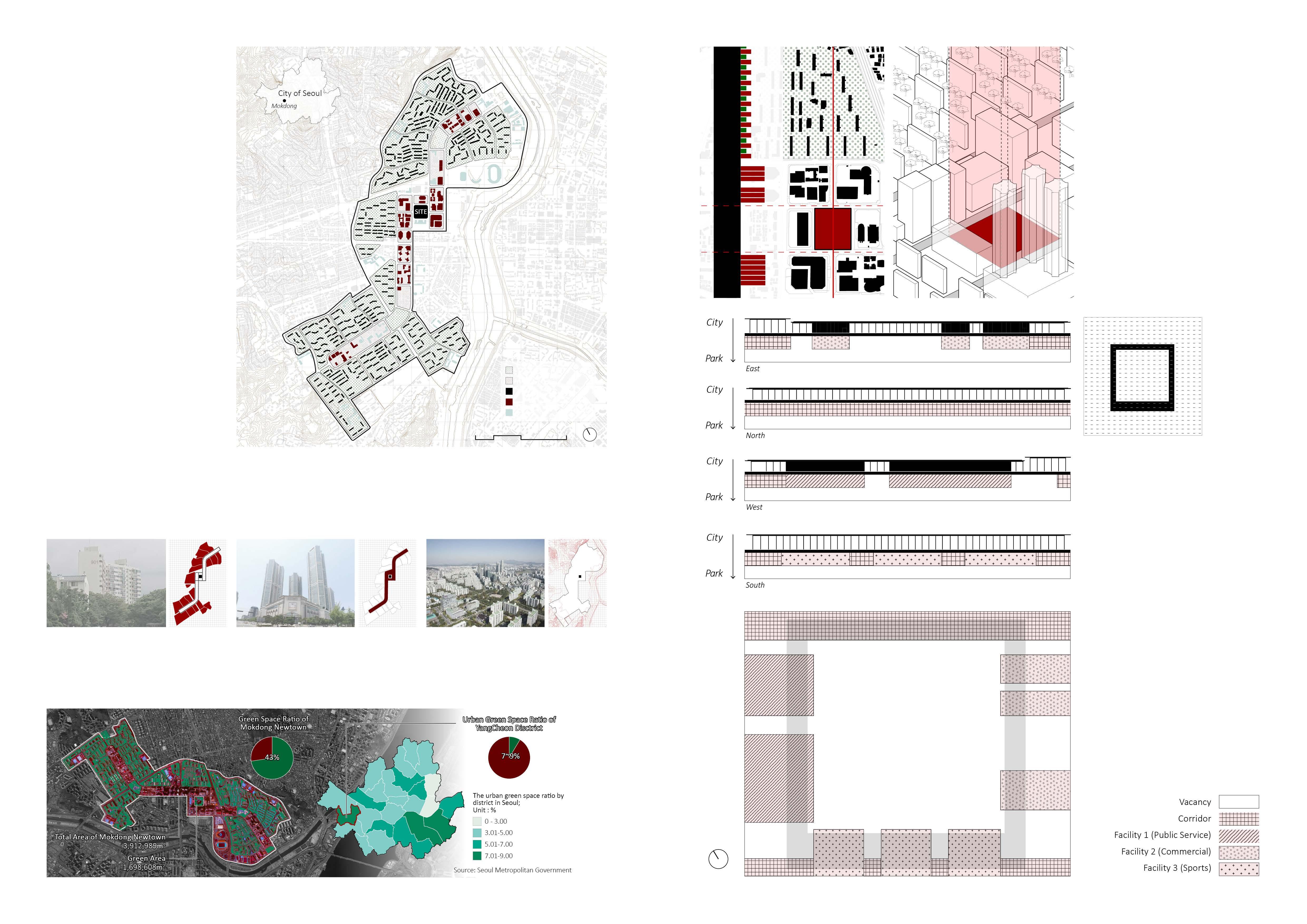
The city’s layout was based on Hook's linear urban theory, with strict separation of residential and commercial areas and roads for cars. The city of Mok-dong was planned and built in the 1980s. The design was influenced by Hook's linear city planning.
The previous generation's grand plan had many advantages, but societal changes have led to unforeseen shortcomings. It is now time to revise the plan through new approaches.
Dense Green, Buildings
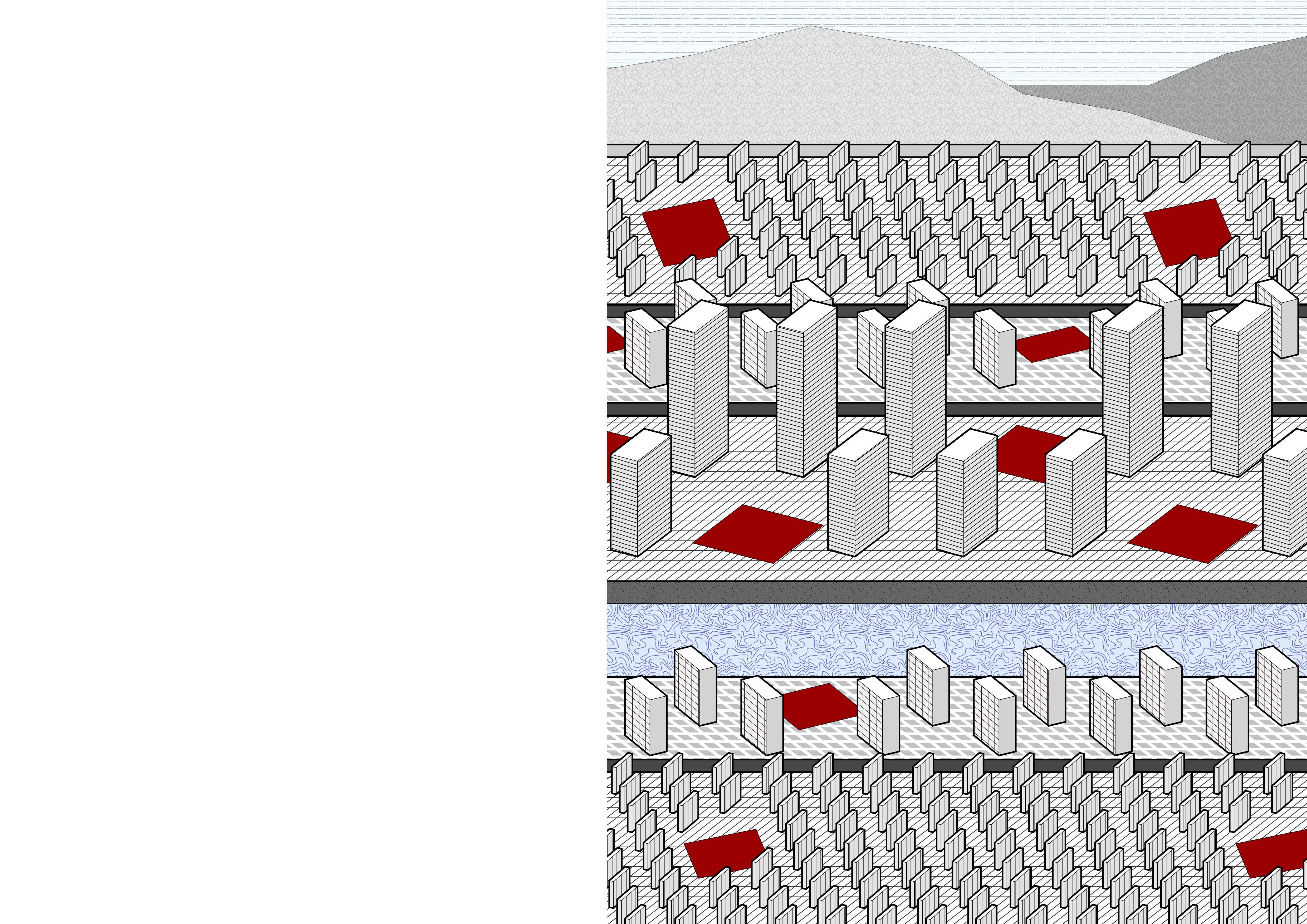
Mok-dong was designed as a suburban town with a forest by segregating pedestrians and vehicles. However, high-rise apartments and trees have turned Mok-dong into a highly dense residential complex.
Blocked Sky Town of Flat land
The sky view in Mok-dong has been overtaken by tall buildings, making it difficult to see anything but concrete and glass walls. Unlike its original urban plan, Mok-dong has become densely populated with high-rise apartments.
Mok-dong New Town is situated on low land in Seoul, so its landscape is flat without any slopes. This means that citizens who spend most of their time in the area are limited to experiencing life on the flat plains.
The Mokdong New Town urban plan resembles a suburban area, blending residential spaces with abundant greenery. Green space analysis shows an impressive 43% green coverage, significantly higher than the 7-9% urban green space rate in Yangcheon-gu, Seoul, where Mokdong is located. I question whether urban parks in the Mokdong New Town plan should solely serve as green spaces, given diverse interpretations of their function from both macroscopic and microscopic perspectives.
Trees are also an important part of creating a dense urban environment, but this was not taken into consideration during the planning of Mok-dong. Definitely, trees and high-rise buildings have resulted in a lack of low-density areas.
← Vacant Open Space
The empty open space in Mok-dong offers residents a chance to experience unfamiliar and blank spaces. By diluting the city's high density through the void, the city's density is restored to equilibrium.
Shallow Urban Bands
The park of vacancy offers activities and programs for Mok-dong residents through fragmented bands that connect the inside and outside of the site. These programs are arranged to respond to the surrounding urban context and the needs of citizens.
For example, commercial bands near the department store and main streets are connected to support citizens' consumption activities. Public office spaces near residential areas respond to citizens' everyday lives.
The bands do not fully enclose the site but create a loose boundary between the empty hills and the city.
of Old Residential Area in Seoul
Urban Structure and Characteristics of Old Residential Area in Seoul
The new park offers facilities at the edge of the park and a large grassy area surrounded by them. This allows Mok-dong residents to experience new and unfamiliar scenery that they don't normally encounter.
The grassy hill provides a new topography in the flat terrain of Mok-dong, offering residents an unfamiliar but pleasant and peaceful atmosphere.
The public service center in the park
as a bridge between the lives of citizens and the
The addition of auxiliary programs helps to activate the park.
The park offers a unique unrealistic landscape that diverges from the everyday monotony of life in Mok-dong.
Empty Grassland Public Service Center
Unrealistic Scenery Revised Urban plan in response to Society
serves
park.
This proposal challenges the urban planning of the 1980s. It responds to changes in society with a flexible approach, but does not try to control everything.
Yonsei Architecture 4-1 Academic Project
Year: 2016
Location: Seoul, Republic of Korea
Type Office
Category Individual Academic Work EVENT HORIZON Instructor: Lee Sang Yun
Office buildings typically have a podium and an upper tower for workstations. However, the massive facade of these buildings can create a barrier facing the road, and the podium can become a closed-off public space. While the lower part of the office building can promote the corporate motto and generate profits through commercial facilities, its form serves a purpose other than this. The psychological barrier in front of the building acts like the event horizon of a black hole, preventing people from imagining what happens in the space beyond that line.
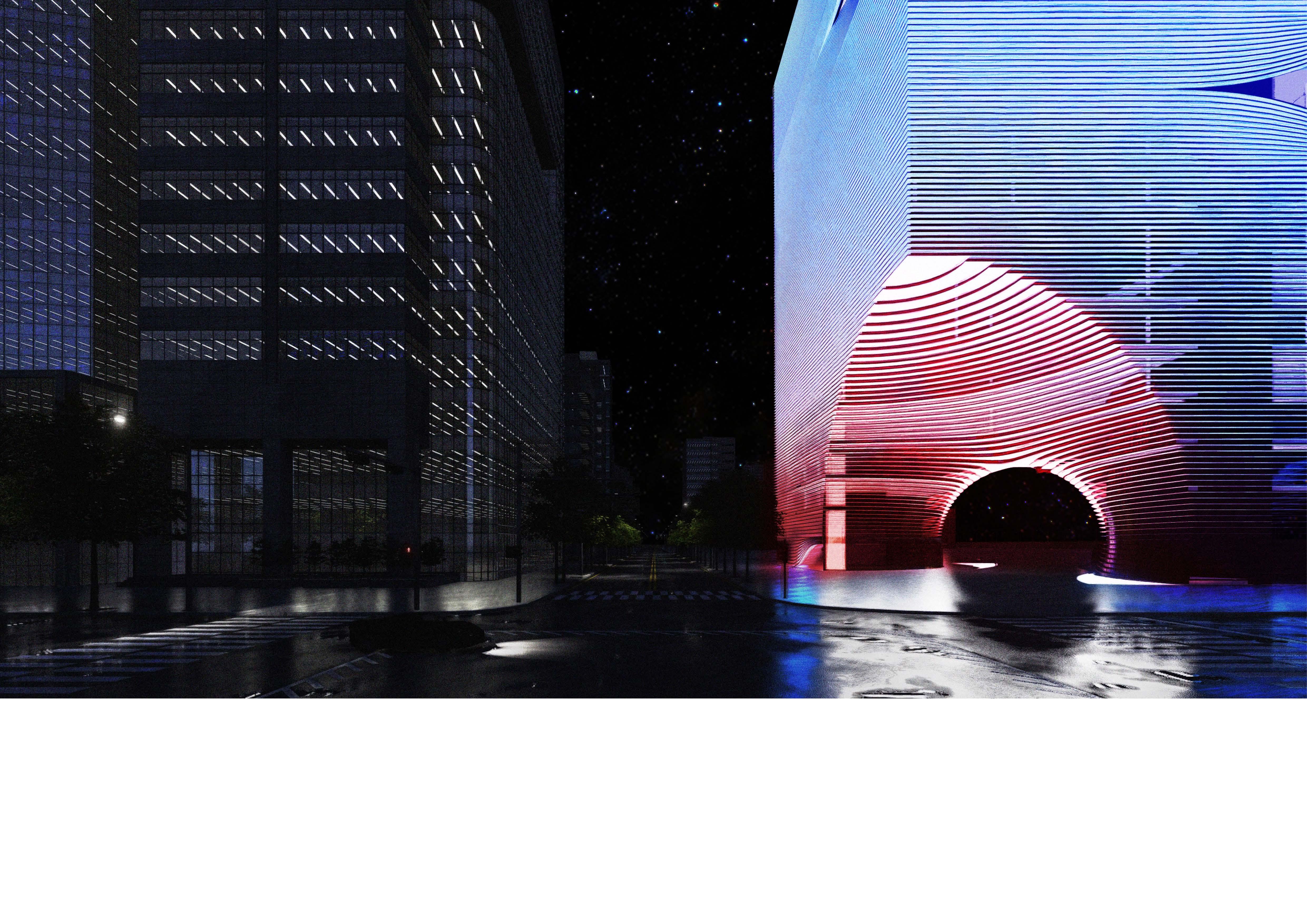
"Event Horizon" challenges the long-accepted architectural form in Gangnam Street. By creating a void space resembling a giant warp, it destroys the rigid atmosphere and embraces the city's bustling life. As citizens walk on the streets, they can cross the event horizon and encounter a new universe that they have not experienced in their own.
Event Horizon in Urban Environment
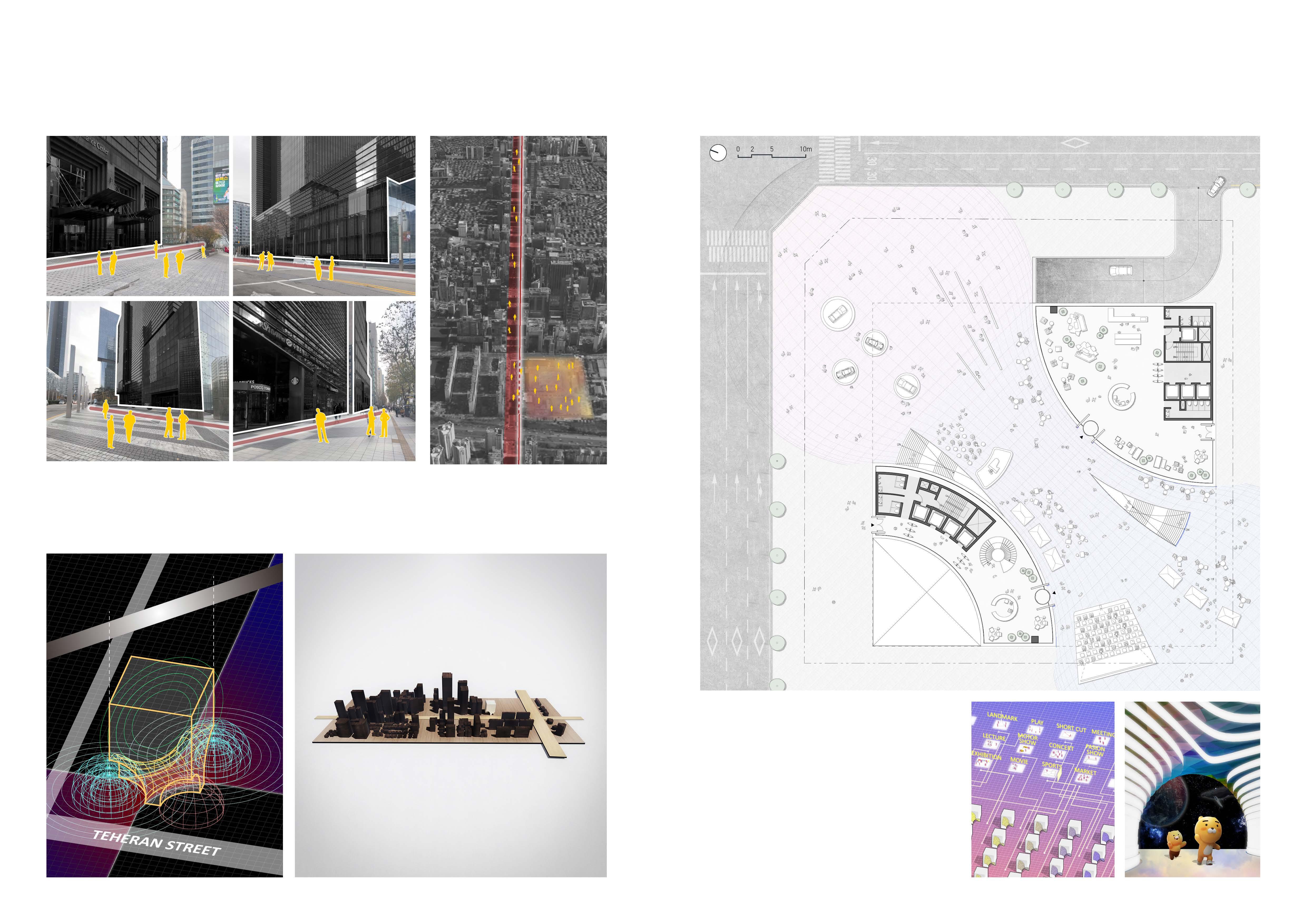
The cluster of high-rise office buildings in Gangnam, Seoul, creates a series of lines on the sidewalk that are difficult for non-office users to cross. This project aims to allow citizens to experience a new type of office podium beyond the virtual “Event Horizon” line created by the high-rise office architecture.
Breaking the Rigidity of the city
The site is located at the western end of Gangnam Street. At the start and end of the street, a void space allows random people to enter freely and connect opposite sides of the site. This converts the rigid and fast straight movement of citizens in Gangnam to an unexpected direction, allowing them to naturally cross the event horizon and enter the office building program.
Lobby of City beyond the Event Horizon
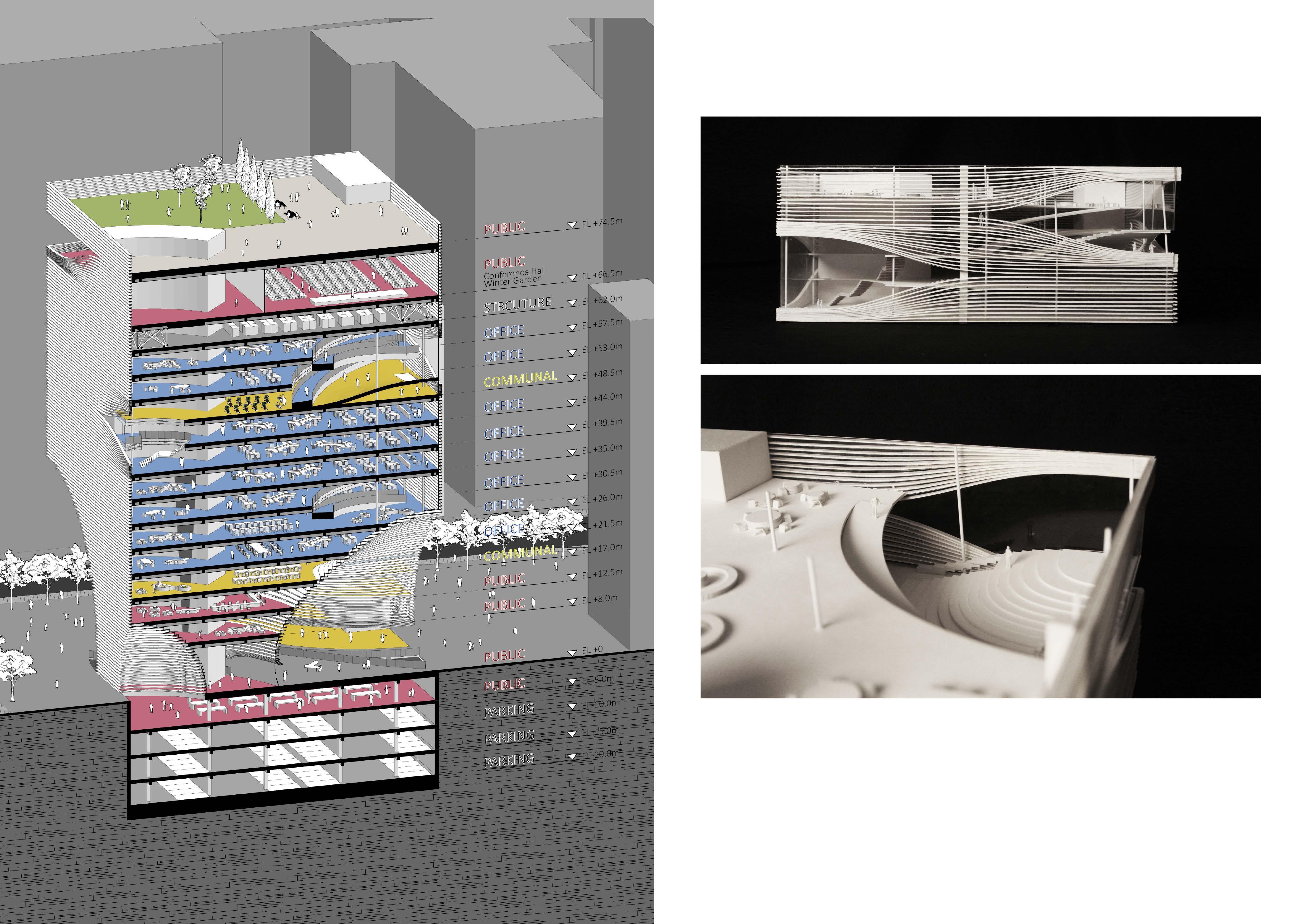
The enormous parametric void space breaks the urban context of Gangnam and blends with the busy streets. This "Urban Lobby" creates the possibility for new activities, such as concerts, exhibitions, and festivals, that the first floor of the office building has not made possible. Citizens can flow naturally into the underground retail area along the warp flow.
Despite the plan to maximize publicity, the lobby and core of the work area are compact and independent to suit the purpose, allowing office users to move vertically conveniently.
1F, Kakao Media Park
Kakao is a Korean IT company that leads in music distribution and production, as well as various technologies such as online messengers, autonomous driving mobility, online banking systems, and online shopping platforms like Google. The external lobby, freely open to citizens, becomes an offline park where events are held based on Kakao's services. The void space is planned with a media facade, providing a new scenery that has not been seen before on the streets of Gangnam.
Gangnam Finance Center 152, Teheran-ro, Gangnam-gu
Samsung Insurance Headquarter 11, Seocho-daero 74-gil, 4, Seocho-gu
Samsung Electronics Headquarter 11, Seocho-daero 74-gil, Seocho-gu
Posco Tower 134, Teheran-ro, Gangnam-gu
The Event Horizon in Gangnam Street New experience beyond the Event Horizon
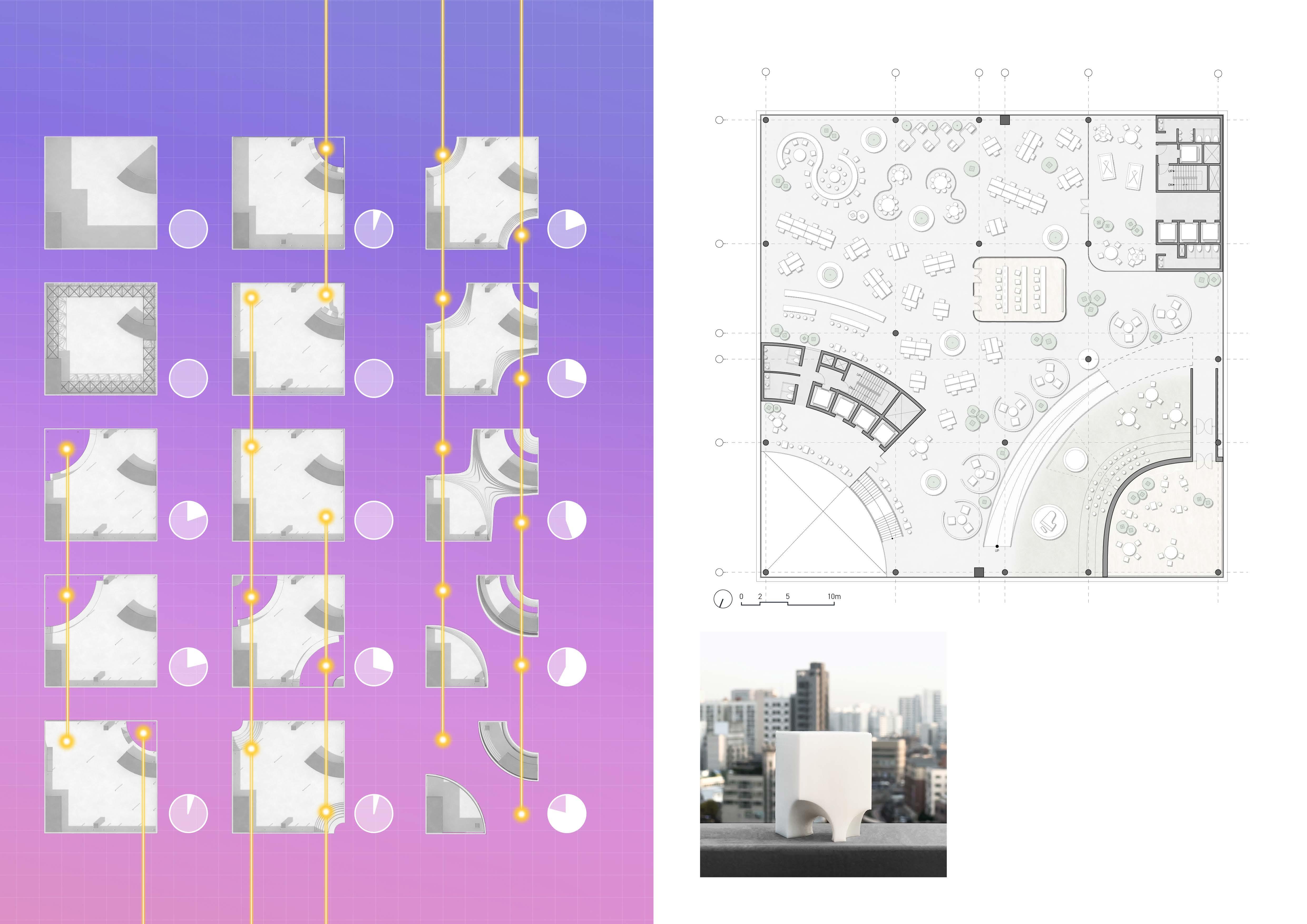
"Event Horizon" connects the lower floors of an office building with a void space that continues to the upper floors. This allows for active movement between floors, creating a continuous connection and a more engaging work environment without vertical disconnection.
11F, Kakao Workstation
The workstation plan allows employees to choose and use multiple collaboration spaces and personal workspaces, reflecting Kakao's emphasis on collaboration between different fields. This enables employees to work autonomously and in a way that best suits their needs.
Mass Design Approach
The maximum building coverage ratio is applied to the mass design to make the most of the vast area of the media park. This allows for a variety of activities by citizens on the lower levels and for collaboration by employees from different departments on the large open work floors on the upper levels.
PROGRAM COMPOSITION & STRUCTURE
The program composition focuses on the interconnection between various programs and workstations. The communal spaces in the middle of the work floors are important for connecting the upper and lower levels. The hanging structure allows for an open plan on the top floor that can be used as a conference hall. The below floors are supported by the structure floor, mega columns, and cores.
The facade design of the upper work area mirrors the shape of the void space in the lower part. The horizontal bands come together in a curved form to create a pleasant glass facade that is open to the urban landscape in the shared area of the work floor. This part serves as a showcase for citizens walking on Gangnam Street.
1 : 100 Partial Model (9F ~ 13F) Facade Design Approach
SEOUL IS TOO HOT
Cornell Architecture 2023 Fall Elective
Year: 2023
Location: Seoul, Republic of Korea
Type : Research
Category : Individual Academic Work
Analysis of Accessibility for Low-Income Elderly Individuals to Cooling Center Facilities and Proposal for New Cooling Center Locations
The primary objective of this study was to evaluate the effectiveness of Cooling Centers in each administrative district, with a focus on their capacities to meet the rising demand. By doing so, this research aims to contribute valuable insights to the provision of welfare services in appropriate locations.
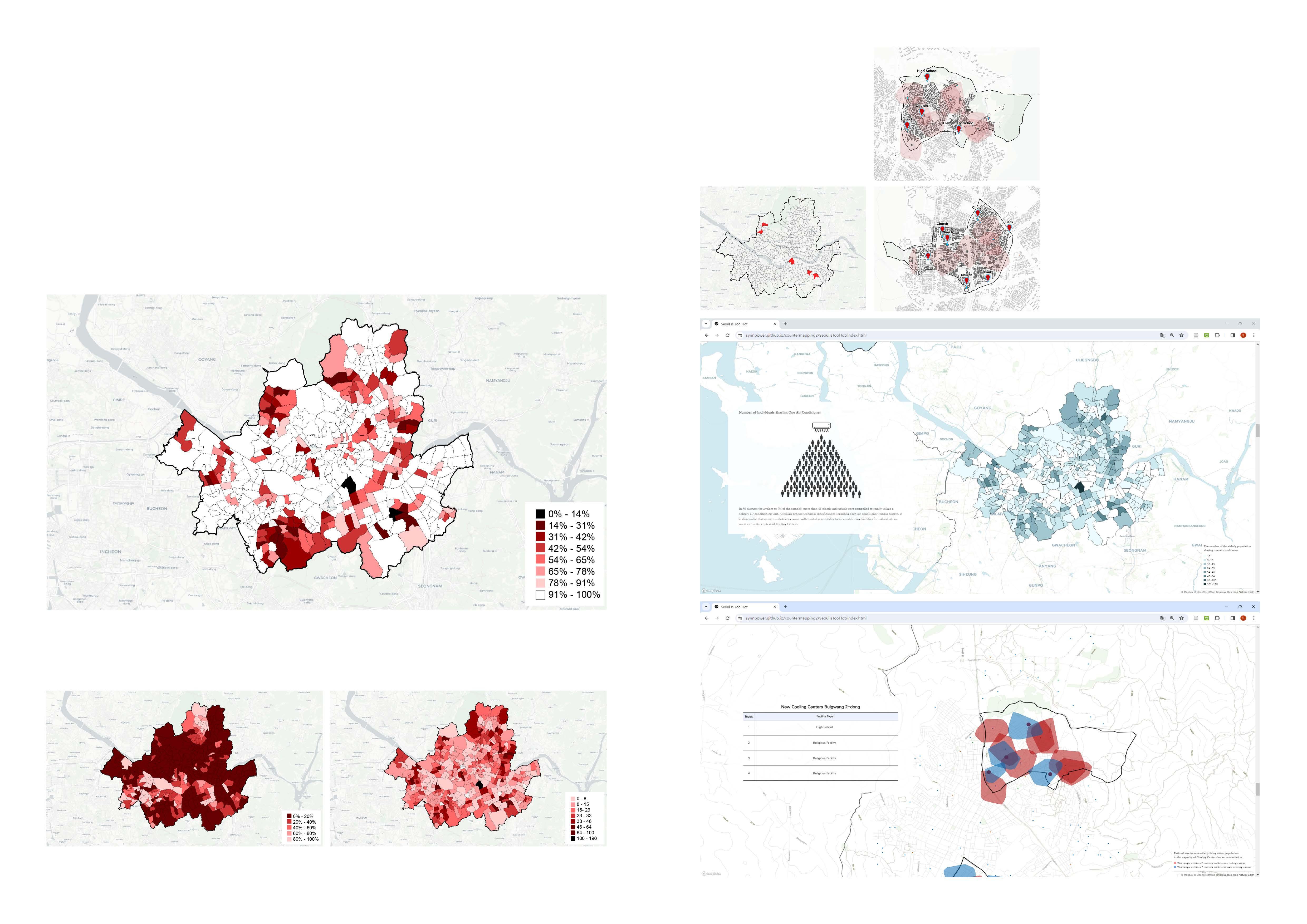
Ratio of low-income elderly living alone population to the capacity of Cooling Centers by administrative district.
The data underscores the insufficiency of Cooling Center capacity in relation to the vulnerable elderly population in numerous geographical zones. In particular, it is noteworthy that a total of 69 administrative districts, constituting 16% of the overall administrative districts, exhibited a ratio of vulnerable elderly population to total capacity that fell at or below 50%.
New Cooling Centers Location Proposal
In designating new Cooling Centers for each administrative district, the primary consideration was pedestrian accessibility. To select locations that could be reached within a 5-minute walk by the vulnerable elderly population, suitable facilities were sought within areas not covered by the previously analyzed isochrone depicting pedestrian accessibility.
Ratio of low-income elderly living alone population to the capacity of Cooling Centers for accommodation.
The number of the elderly population sharing one air conditioner
https://synnpower.github.io/countermapping2/SeoulIsTooHot/index.html
The objective of this course was to produce a website that showcases the analysis results obtained through Urban Data Analysis, enabling students to gain hands-on experience in Data Visualization. Through the storytelling aspect of the website, the intention was to effectively disseminate research findings to the general public and create materials that make it easy to comprehend societal phenomena.
New Cooling Centers for Yeokchon-dong Yeokchon-dong
STREET COMPLETENESS; PUBLIC TRANSIT ACCESSIBILITY
Georgia Tech Graduate Research Assistant
Year: 2024 - Ongoing
Location: Atlanta
Type : Research
Category : Urban Data Analysis Assisted Prof. Subhro Guhathakurta
Develop a new framework for evaluating Street Completeness
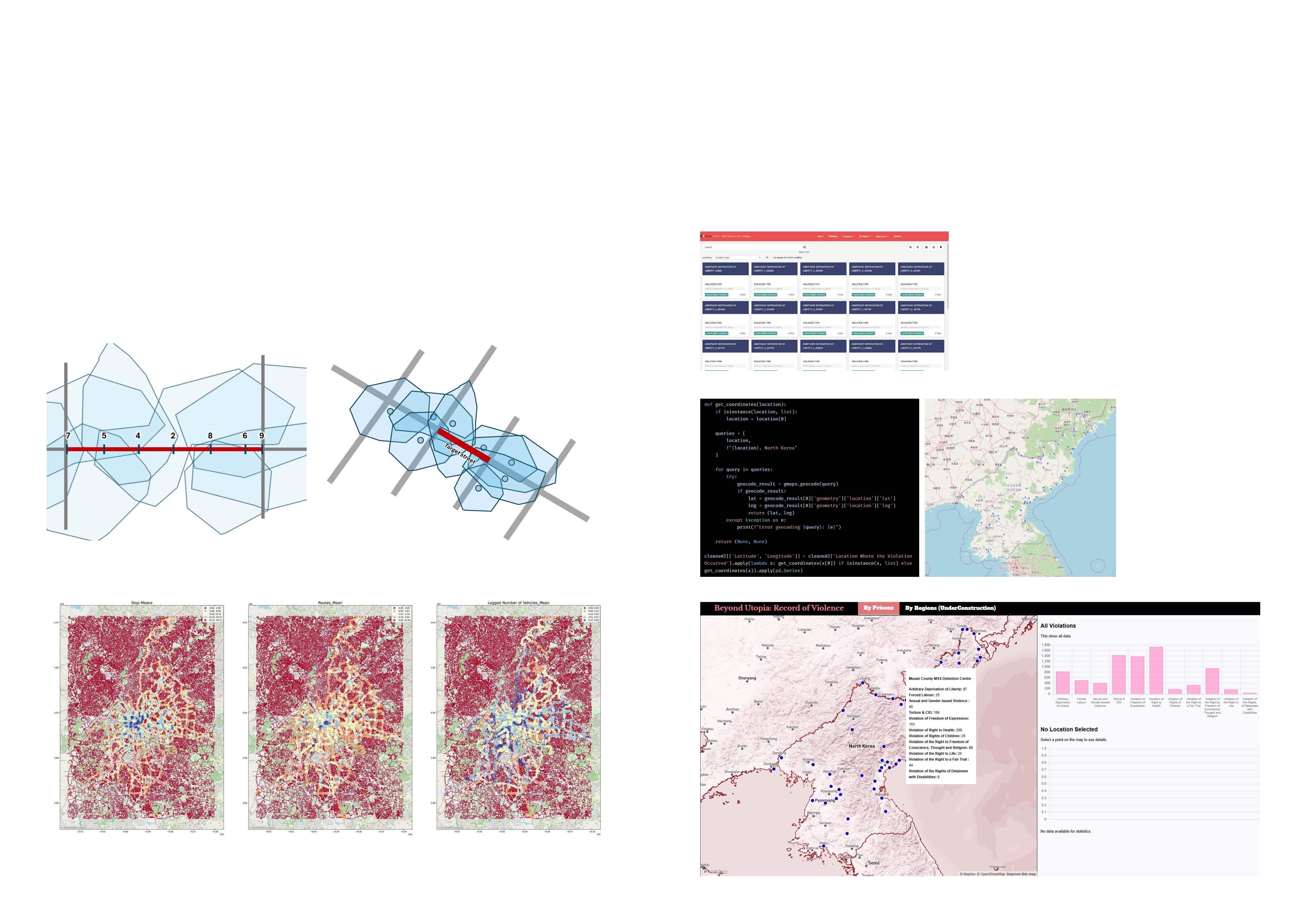
The goal of this research project is to develop a new framework for evaluating street completeness in the Atlanta Metropolitan Area. My role involves using GTFS data to assess public transportation accessibility on individual streets. Specifically, I am creating a Python-based methodology to analyze and evaluate accessibility within the street network. GTFS data includes information on stop locations, routes, schedules, and transportation types. By manipulating this data, my research focuses on determining how many public transit stations or stops pedestrians can access within a 15-minute walk, the number of available vehicles, and the routes they can utilize. Once the results are finalized, our team will combine the findings to establish a scoring system that evaluates street completeness.
Using Innovative Analysis Methods
Few studies have examined public transportation accessibility in the Atlanta area using a network-based approach. This research provides a comprehensive evaluation of Atlanta’s public transit system by incorporating data from all bus and subway stations in the city. The analysis employs isochrone geometries derived from the street network, enabling the swift calculation of accessible stops and their relevant details for each street. This approach facilitates the creation of an effective framework for assessing street completeness.
BEYOND UTOPIA
Georgia Tech 2024 Fall City & Regional Planning Elective (Geo-Visualization)
Year: 2024
Location: North Korea
Type : Research
Category : Individual Academic Work, Instuctor: Prof. Clio Andris
Geospatial Visualization of Human Rights Conditions in North Korea
This study evaluates the effectiveness of an Interactive Map in conveying the reality of human rights abuses in North Korean prisons and engaging public interest in the issue. The ultimate goal is to transition from a generalized understanding, such as "human rights abuses are widespread in North Korea," to providing users with detailed and memorable information by developing and distributing the Map.
The North Korean Prison Database, a project by "Korea Future," documents human rights violations through detailed archiving efforts. The project focuses on cataloging these violations by conducting interviews with victims, witnesses, and perpetrators. The database contains 9,150 entries, providing information on violation types, date ranges, and specific locations, including addresses.
As the dataset lacked geographic coordinates for the prisons, I relied on the provided addresses for geolocation. Using the Google Maps API, I processed approximately 9,000 entries. Notably, while around 2,000 addresses were unrecognized by Google Maps, the API successfully generated coordinates for the remaining 7,000 entries. I then grouped the data by coordinates to compile the final dataset.
Evaluating Transit Accessiblity
Data Source: North Korean Prison Database
Geocoding Prison Data with Google Maps API
Website Publish
COFFEE ENDING
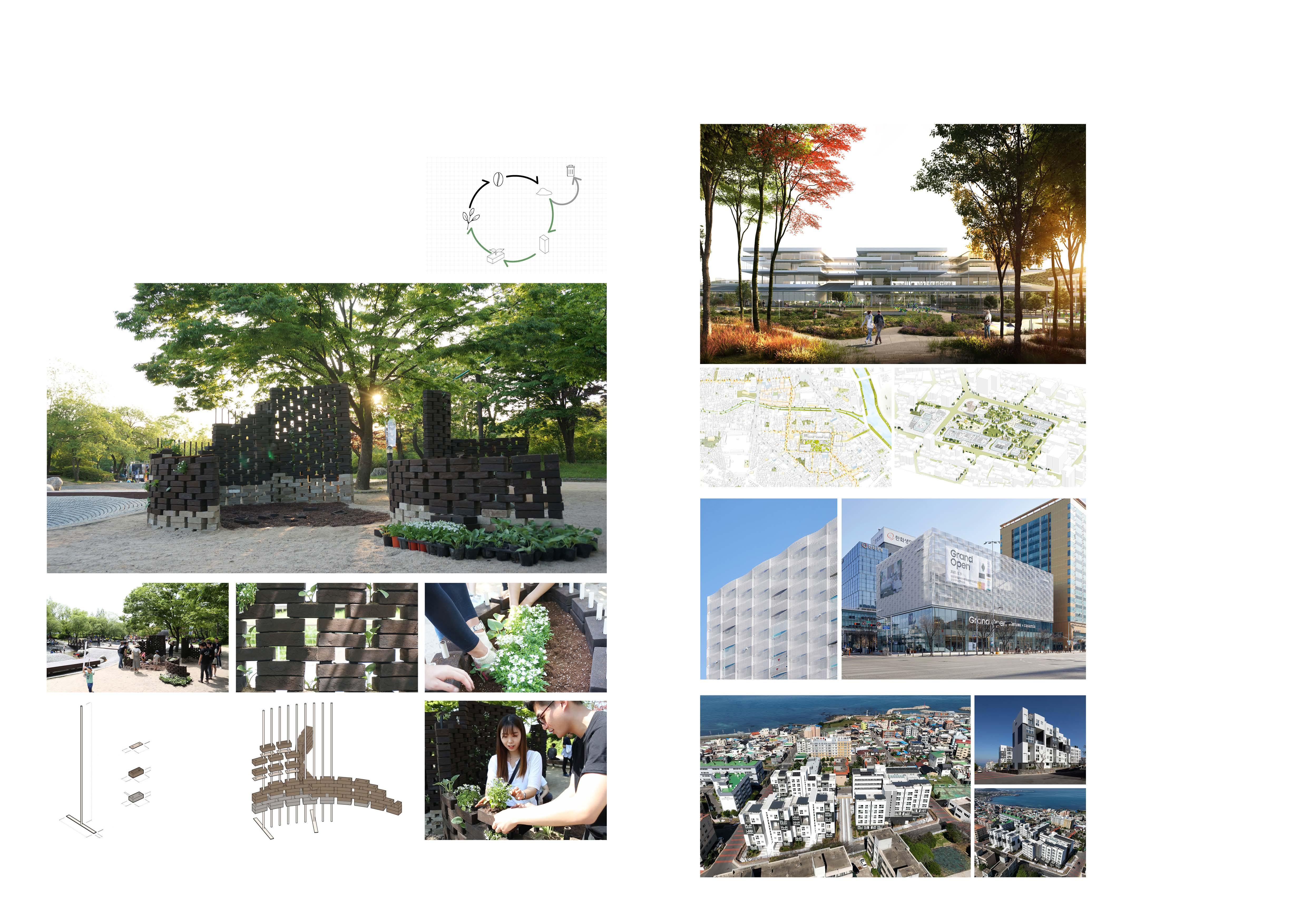
"Coffee Ending" is a project that explores the use of coffee grounds as a building material.