CHILLESFORD
CLAY – MUDDYING AND UNMUDDYING THE WATERS HOWARD B MOTTRAM
Introduction
The Chillesford Clay, which is about two million years old, is a well known Member of the Norwich Crag Formation in Suffolk. The Chillesford Clay is usually a silty clay of dark grey colouration, but it can be light grey or brown. It is only up to about 5m thick and was not always deposited and, even when it was deposited, it didn’t always survive. Where it survived in eastern and southern Suffolk, it marks the top of the preserved Norwich Crag Formation. In north-eastern Suffolk the Chillesford Clay is overlain by the Westleton Beds Member of the Norwich Crag Formation and in this area of Suffolk the Chillesford Clay can be a useful marker horizon for separating the underlying Chillesford Sands from the overlying sands of the Westleton Beds.
There have been several interpretations and reinterpretations on the recognition and mode of occurrence of the Chillesford Clay. In this article these are discussed with a view to clarifying the situation.
The areal extent of the Chillesford Clay
Eastern Suffolk (the area around Sudbourne)
In 1849, Joseph Prestwich described sand overlain by mud that persisted in eastern Suffolk in the vicinity of Chillesford. He subsequently named the sand as the Chillesford Sand and the overlying mud as the Chillesford Clay (Prestwich, 1871). The Geological Survey of Great Britain identified the Chillesford Clay more widely in eastern Suffolk and showed this on geological maps of the area that it published between 1882 and 1884. Re-surveying carried out by the BGS (British Geological Survey) between 1982 and 1999 interpreted the outcrop slightly differently. This revised interpretation of the outcrop is used in Fig. 1.
North-eastern Suffolk
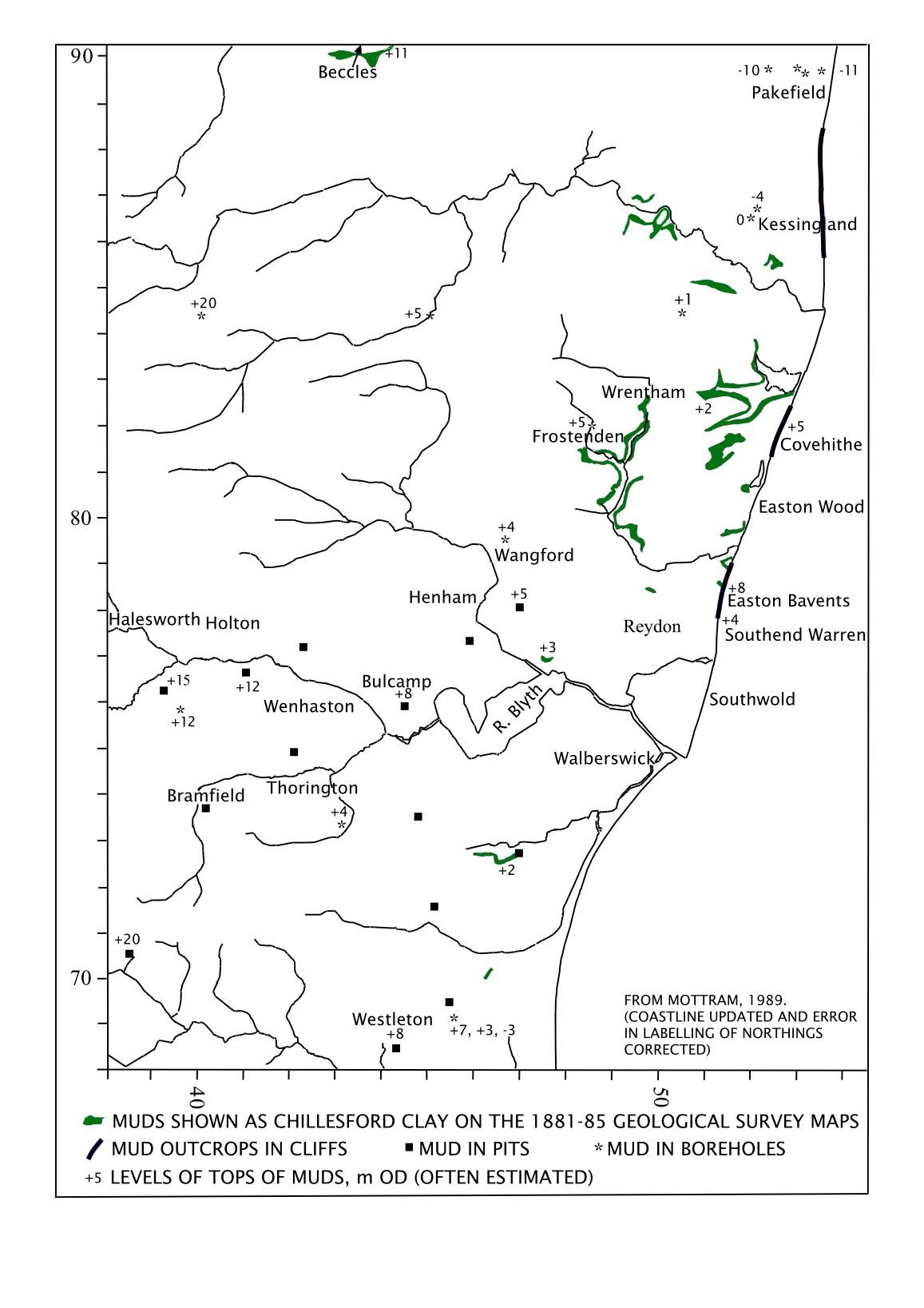
The original mapping by the Geological Survey identified Chillesford Clay between Westleton and Kessingland, see Fig. 2. Almost a century later, analyses of the mud in the cliffs of Easton Bavents and Covehithe revealed that the mud there had a heavy mineral content with a high proportion attributable to Scandinavia. This suggested a glacial supply (Funnell & West, 1962) and in the follow-up research, it was concluded that the pollen, molluscs and foraminifera reflected a cold environment (West et al., 1980). It was submitted that this mud was therefore of a different provenance and possibly of a different age to the mud around Chillesford. In consequence, the mud at Easton Bavents and Covehithe became referred to as the Baventian Clay (West et al., 1980) and then as the Easton Bavents Clay (Gibbard & Zalasiewicz, 1988). However, it was subsequently demonstrated that the flora and fauna of the Chillesford Clay in the Chillesford area also reflected a cold climate and that the heavy mineral contents of the Chillesford Clay and the Easton Bavents Clay were not dissimilar (Zalasiewicz et al., 1991). On the basis of these findings, it was proposed that the two muds were not totally different strata but fully or partly lateral equivalents of each other.
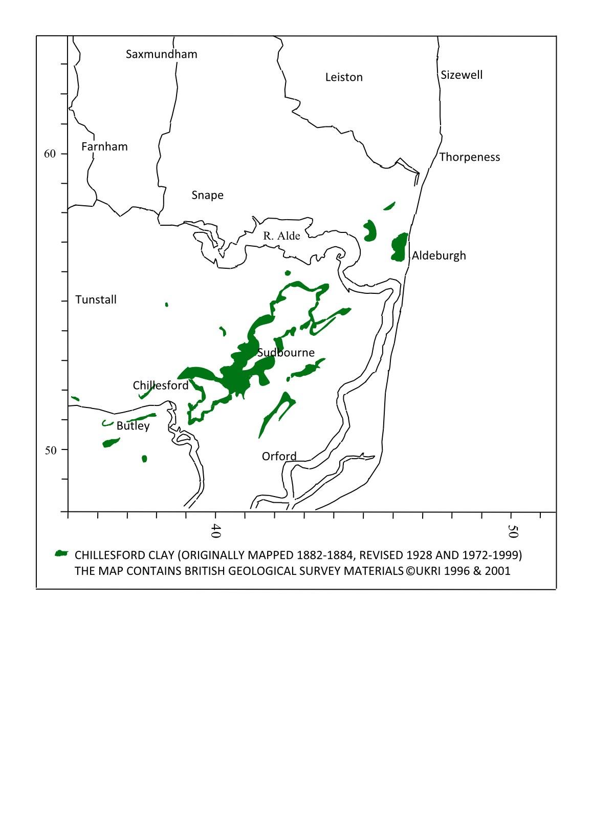
Figure 1 The Chillesford Clay in eastern Suffolk (around Sudbourne)
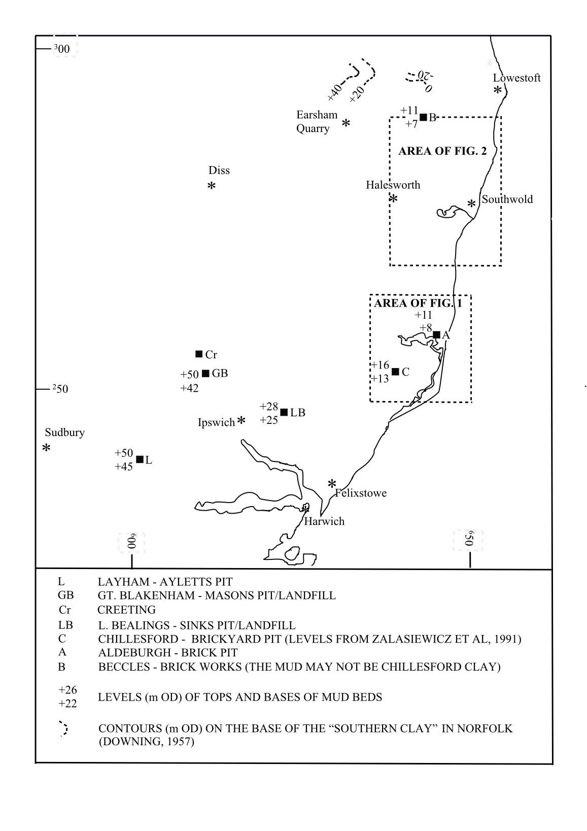
proposed that this mud correlated with that at Easton Bavents (Spencer (1967, p292; 1972, p.341). At Great Blakenham, in Masons Pit (around NGR TM 1080 5023), the mud was given the local name of College Farm Silty Clay (Allen, 1984), but soon afterwards the mud hereabouts was correlated with the Chillesford Clay on the grounds of the resemblance of its basic lithological characteristics to those of the muds at Chillesford (Mathers & Zalasiewicz, 1988). This lithostratigraphic correlation was reinforced by (a) what was stated to be the reasonable geographical closeness (27km) of the outcrops at Great Blakenham and Chillesford and (b) that they contained similar Palaeozoic and Mesozoic palynomorphs which suggested that they had a common provenance (Moorlock et al., 2002). Some researchers disputed the foregoing and continued to maintain that the mud in the Creeting area was not equivalent to the Chillesford Clay, reiterating that the College Farm Silty Clay (aka College Farm Member) must have been a temperate freshwater deposit due to the types of plant remains and pollen that it contained (Catt et al., 2006). These latter researchers also proposed that the mud in Masons Pit was possibly of a slightly older age to the mud of the Chillesford pits. However, as the deposition of the Chillesford Clay progressively followed the eastward shrinking away of the North Sea, the Chillesford Clay was diachronous and so it is possible that the earliest/oldest (western) outcrops coincided with a time when the climate was deteriorating but had not yet become cold (Moorlock et al., 2002).
The Waveney valley and into Norfolk
In Figs. 2 and 3 it can be seen that the level at which the Chillesford Clay occurs dips down approximately eastwards, towards the axis of the North Sea basin, but that any mud recorded north of Kessingland and into Norfolk also demonstrates a northward and more variable component to its dip. It should also be noted that since the original geological maps were published in the 1880s, remapping by the BGS in the 1990s reinterpreted the stratigraphy in the northern-most parts of Suffolk. As a consequence of this remapping, the mud on the southern side of Beccles, which was originally attributed to the Chillesford Clay, became assigned to the Anglian glacial deposits. Subsequent to this, a new addition to the stratigraphic column, the Wroxham Crag Formation, was inserted immediately above the Norwich Crag on the basis of lithological content. There are currently no details of how this may apply directly to the stratigraphy at Beccles, but the results of investigations at Earsham Quarry (Holmes et al., 2018), which is only 11km further west (around NGR TM 3155 8902), raise the question as to whether what had been identified to be within the upper beds of the Norwich Crag at Beccles could be reassigned to the Wroxham Crag. There are therefore uncertainties regarding the identification of the Chillesford Clay in northern-most Suffolk and into Norfolk but, nonetheless, there is still much merit in continuing to use the admirable 1880s geological mapping as a guide to the distribution of the Chillesford Clay.
The palaeogeography
The depositional environment of the Chillesford Clay
Frequently, the Chillesford Clay abruptly succeeded the Chillesford Sands but at some
3
Trans. Suffolk Nat. Soc. 60 (2024)
Figure
The Chillesford Clay and possible correlatives
locations the junction was “blurred” where the two lithologies alternated for up to 1.5m. The Chillesford Clay often expressed itself simply as horizontally laminated muds but, significantly, at a few sites the features clearly demonstrated an inter to high tidal origin;-
• Sinks Pit, Little Bealings, around NGR TM 2230 4653: mud was poorly represented in most of the site, occurring as laminations within the sands, but mud had accumulated as the horizontal infill of a channel that was symmetrical in the exposure and approximately 3m deep x 30m wide.
• Hill Farm Pits, Wangford, at NGR TM 4685 7805: mud lined a creek approximately 3m deep x 3m wide that had meandered over 130m: meander lag and root traces (cordgrass?) were observed (Mottram, 1988).
• The Covehithe-Benacre cliffs, between NGR TM 5250 8131 and 5323 8320: hightidal mud was seen exhibiting drainage rills that were spaced 2 to 3m apart and which contained collapse features: desiccation cracks also occurred (Mottram, 1989; 2006).
Earlier, it was mentioned that during the deposition of the Chillesford Clay, the climate in the region was generally cold but not glacial. Glacial conditions would have existed further north, perhaps in Scotland but certainly in Scandinavia. As the ice-caps expanded, the North Sea would have shrunk away (regressed) so that the East Anglian coastline moved eastwards. We know that the underlying Chillesford Sands were the product of a shallow marine environment. From the descriptions of the sedimentary structures in the sands, e.g. Allen, 1984; Mathers & Zalasiewicz, 1988, it is likely that tidal processes were dominant over wave processes and that tidal processes continued to dominate when the Chillesford Clay was deposited. In other words, if fine sediment was available when the water became even shallower and quieter, the Chillesford Clay accumulated in tidal mud flats. The BGS Regional Guide (see Mathers & Hamblin, 2015) suggests that the muds may have accumulated within estuaries. Strictly speaking, this could not have been so as estuaries occur when a sea is drowning the river mouths and the land (i.e. a marine transgression) rather than when the sea is shrinking away (a marine regression).
The source of the muddy sediment
It is understood that the muds in southern and eastern Suffolk were supplied with fine sediment by a major river, an early proto-Thames, and it has been argued that the equivalent muds in north-eastern Suffolk were fed by a separate major river, an early Ingham/Bytham river (e.g., Rose et al., 2001). As these two major rivers would have drained catchments with different upland geologies, it might be expected that their muds would have slightly different compositions. However, when Zalasiewicz et al., 1991, compared samples from eastern Suffolk with samples from north-eastern Suffolk, they found that the overall heavy mineral contents of the samples were not only similar to each other but also to Red Crag sands and they concluded that all three deposits had a common provenance. Even if the heavy mineral data is grouped into the initial source regions, for example as per Holmes et al., 2018, the data still does
not show clear differences between the purported river supplies. Additional analytical work, which largely focused on stable varieties of the heavy minerals, was carried out on various strata in north-eastern Suffolk and it was concluded that the Norwich Crag was either (a) derived from the same source that had supplied the Paleogene sediments or (b) that Paleogene sediments had been reworked into the Norwich Crag (Hallsworth, 1994).1
When Riding et al., 1997, studied the derived palynomorphs in the Chillesford Clay between Chillesford in eastern Suffolk and Covehithe in north-eastern Suffolk, they only found a small proportion of Silurian palynomorphs in 1 borehole near Chillesford. It was thought that these palynomorphs were obtained from Silurian rocks in the Welsh Borderlands and that they were delivered to eastern Suffolk by the protoThames. Now, as mentioned above, the Chillesford Clay at Great Blakenham in southern Suffolk is also believed to have been supplied via the proto-Thames. However, when Moorlock et al., 2002, studied the Chillesford Clay from Great Blakenham, they didn’t find any Silurian palynomorphs among the derived palynomorphs. This indicated that investigation based on Silurian palynomorphs is not a reliable method of distinguishing sediment delivered by the proto-Thames from sediment delivered by other rivers.
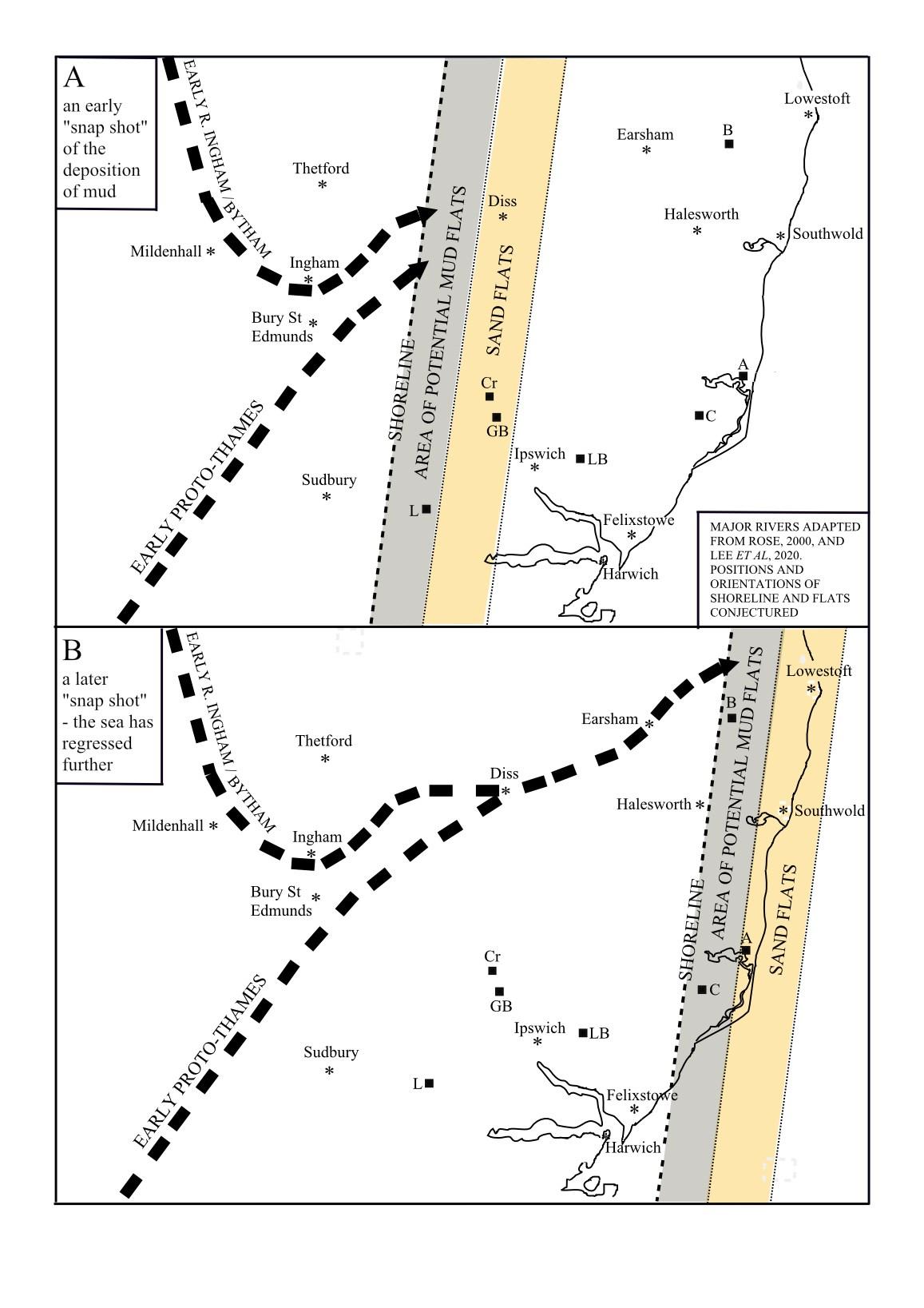
In the last 40 years, there has been a lot of work to trace the two major Pleistocene river systems in Suffolk. From this work it seems that the proto-Thames and the early Ingham/Bytham rivers came close to one another near Bury St Edmunds. When the shoreline was between Bury St Edmunds and Diss, and the two major rivers were feeding separately into the North Sea, their discharges would have been so close to each other that their sediment loads would have soon mixed in the sea, see Fig. 4A.
More recently, Lee et al., 2020, have proposed that when the shoreline was east of Diss, the two major rivers converged. Therefore, their sediment loads would undoubtedly have mixed before being discharged into the North Sea, see Fig. 4 B. On this basis, it is unlikely that the muds of north-eastern Suffolk would have had a significantly different composition to those of eastern Suffolk.
Discussion
The Chillesford Clay was deposited in the intertidal to high tidal zone of the North Sea as the sea regressed. It is possible that the shallow marine environment of southern Suffolk may have been influenced by only a single major river, the proto-Thames. Nonetheless, the mud here was a forerunner of the mud of eastern and north-eastern Suffolk and without a reasonable method of differentiating it in the field or laboratory, it is pragmatic to avoid resurrecting the use of the term College Farm Silty Clay, but to continue to refer to the mud of southern Suffolk as Chillesford Clay.
1 Sample T5 was the only Norwich Crag mud that was analysed, and it was probably from the Westleton Beds rather than the Chillesford Clay.
In the eastern and north-eastern areas of Suffolk, the shallow marine environment was probably influenced by the combined proto-Thames river with the Ingham/ Bytham river. Therefore, under modern stratigraphical procedures, it is correct to discard the use of the name Easton Bavents Clay in favour of Chillesford Clay.2
Conclusions
It is humbling to note that, in many ways, the pioneering work of Prestwich and of the Geological Survey of Britain stands up well some 150 years later. Their Chillesford Clay still reigns. Long live Chillesford Clay !!
References
Allen, P. (1984). 4. Creeting Formation. In Allen, P. (ed) Field guide to the Gipping and Waveney valleys, Suffolk, May, 1982. 10-13. Quaternary Research Association. Catt, J. A., Gibbard, P. L., Lowe. J. J., McCarroll, D., Scourse, J. D., Walker, M. J. C. & Wymer, J. J. (2006). Quaternary: ice sheets and their legacy. in Brenchley, P. J. & Rawson, P. F. (eds), The geology of England and Wales. 429-467. The Geological Society of London. Downing, R. A. (1959). A note on the Crag in Norfolk. Geology Magazine, 96: 81-86. Funnell, B. M. & West, R. G. (1962). The early Pleistocene of Easton Bavents, Suffolk. Quarterly Journal of the Geological Society, 118: 125-141. Gibbard, P. L. & Zalasiewicz, J. A. (eds) (1988). The Pliocene to early Middle Pleistocene of East Anglia: an overview. in Gibbard, P. L. & Zalasiewicz, J. A. (eds) Pliocene-Middle Pleistocene of East Anglia. Field guide. 1-17. Quaternary Research Association.
Hallsworth, C. R. (1994). Variations in the heavy minerals of Plio-Pleistocene sediments in East Anglia: the implications for provenance. British Geological Survey Technical Report WH/94/6/2. British Geological Survey, Keyworth.
Hamblin, R. J. O., Moorlock, B. S. P., Booth, S. J., Jeffrey, D. H. & Morigi, A. N. (1997). The Red and Norwich Crags of eastern Suffolk. Proceedings of the Geologists’ Association, 108: 11-23.
Holmes, P., Rose, J., Lee, J., Barendgret, R., Candy, I. Riding, J. B. & Lewis, M. (2018). The Middle Pleistocene terraces of the central Waveney valley, Earsham, south Norfolk, UK.
Proceedings of the Geologists’ Association, 129: 70-88.
Lee, J. R., Haslam, R., Woods, M. A., Rose, J., Ford, J., Schofield, D., Kearsey, T. & Williams, C. (2020). Plio‐Pleistocene fault reactivation within the Crag Basin, eastern UK: implications for structural controls of landscape development within an intraplate setting. Boreas, 49: 685- 708.
Mathers S. J. & Hamblin, R. J. O. (2015). Late Pliocene and Pleistocene marine deposits. In Lee, J. R., Woods, M. A. & Moorlock, B. S. P. (eds) British Regional Geology: East Anglia (5th edition). 110-129. British Geological Survey, Nottingham.
2 The BGS Lexicon of Named Rock Units is confusing. The entry for the Easton Bavents Clay Member indicates that the BGS no longer recognises the Easton Bavents Clay as a separate Member of the Norwich Crag Formation yet the entry for the Norwich Crag Formation still lists the Easton Bavents Clay and the Chillesford Clay as separate Members.
Mathers S. J. & Zalasiewcz, J. A. (1988). The Red Crag and Norwich Crag Formation of southern East Anglia. Proceedings of the Geologists’ Association, 99: 261-278.
Moorlock, B. S. P., Hamblin, R. J. O., Booth, S. J. & Morigi, A. N. (2000). Geology of the country around Lowestoft and Saxmundham. Memoir of the British Geological Survey, Sheets 176 and 191 (England and Wales). British Geological survey, Keyworth. Moorlock, B. S. P., Riding, J. B., Hamblin, R. J. O., Allen, P. & Rose, J. (2002). The Pleistocene College Farm Silty Clay at Great Blakenham, Suffolk, Englandadditional information on the course of the early River Thames. Netherlands Journal of Geosciences, 81: 9-17.
Mottram, H. B. (1988). Norwich Crag at Hill farm Pits, Wangford. Trans. Suffolk Nat. Soc. 24: 88-94.
Mottram, H. B. (1989). The Upper Caenozoic sequence around The Long Row, Covehithe. Trans. Suffolk Nat. Soc. 25: 86.
Mottram, H. B. (2006). Mud, mud, glorious mud - in the Norwich Crag of Suffolk and in Somerset today. Magazine of the Geologists’ Association, 5 part 1: 17.
Prestwich, J. (1849). On some fossiliferous beds overlying the Red Crag at Chillesford, near Orford, Suffolk. Quarterly Journal of the Geological Society, 5: 345-353.
Prestwich, J. (1871). On the structure of the Crag beds of Suffolk and Norfolk, with some observations on their organic remains. Part III, The Norwich Crag and Westleton Beds. Quarterly Journal of the Geological Society, 27: 452- 496.
Riding, J., Moorlock, B. S. P., Jeffery, D. H. & Hamblin, R. J. O. (1997). Reworked and indigenous palynomorphs from the Norwich Crag (Pleistocene) of eastern Suffolk: implications for provenance, palaeogeography and climate. Proceedings of the Geologists’ Association, 108: 25-38.
Rose, J. (2000). Pre-glacial quaternary processes and events in Norfolk: a review sketch. In Dixon, R. (ed.) 50th Anniversary Jubilee Volume, 66-75. The Geological Society of Norfolk.
Rose, J., Moorlock, B. S. P. & Hamblin, R. J. O. (2001). Pre-Anglian fluvial and coastal deposits in eastern England: lithostratigraphy and palaeoenvironments. Quaternary International, 79: 5-22.
Spencer, H. E. P. (1967). A contribution to the geology of Suffolk – Part 2. Trans. Suffolk Nat. Soc. 13: 290-313.
Spencer, H. E. P. (1972). A contribution to the geology of Suffolk – Part 5. Trans. Suffolk Nat. Soc. 15: 279-356.
West, R. G., Funnell, B. M. & Norton, P. E. P. (1980). An early Pleistocene cold marine episode in the North Sea: pollen and faunal assemblages at Covehithe, Suffolk, England. Boreas. 9: 1-10.
Zalasiewicz, J. A., Mathers, S. J., Gibbard, P. L., Peglar, S. M., Funnell, B. M., Catt, J. A., Harland, R., Long, P. E. & Austin, T. J. F. (1991). Age and relationships of the Chillesford Clay (early Pleistocene: Suffolk, England). Philosophical Transactions of the Royal Society, Series B, 333: 81-100.
Howard Mottram
The Warren, Duckamere, Bramford, Ipswich, IP8 4AH. e-mail: salhow@talktalk.net