3 minute read
Breathing life into the River Brett


The River Brett is a largely rural watercourse that runs from its source near Brettenham through southwest Suffolk before joining the River Stour at Higham. Evidence from historic maps suggests that the location of the river has been significantly altered in the past. More recently, intensive management practices have left the river uniform with steep sides and an over-deep channel. These morphological problems are exacerbated by significant water quality pressures from agricultural runoff and sewage treatment discharges. Because of these issues the River Brett is failing its objectives for the Water Framework Directive (WFD) – a piece of European legislation looking to improve the ecology of our waterways. Currently the River Brett is at poor ecological potential, with poorer than expected fish populations and an unnatural channel shape and size. These are issues that need to be addressed to fulfil our obligations regarding the WFD and ensure the long-term ecological health of this river. A collaborative project involving the Dedham Vale AONB and Stour Valley Project, the Environment Agency and Suffolk Wildlife Trust has helped enhance 1.3km of the River Brett for ecology and wildlife. The works, which were delivered by the Environment Agency’s River Stour Field Team, involved the installation of large woody-debris flow deflectors, the creation of berms and the lowering of artificial embankments. In just under two weeks the team were able to install over twenty individual features that had a visible, instantaneous, positive effect upon the river. These features have dramatically increased the diversity and complexity of river habitats present on the Brett and will benefit a wide range of fish, plant and invertebrate species, helping the River Brett achieve good ecological potential as required under the WFD. Although the progress of this project was dependent upon the efforts of many people, special thanks must go to the landowners, Andrew Scott, John English, Mark Mitchell and Pat Hawes. Without the contribution of any one of these individuals the project would not have been possible as we can only undertake river habitat enhancement projects with landowner agreement. All those involved should be proud of the improvement they’ve brought to this river and the positive change they’ve made to the environment. We’re optimistic that this scheme will be one of many river enhancements to be implemented by the Environment Agency and partner organisations working with landowners across the rivers of Suffolk. If you would like further information on the project, please contact Will Akast, Catchment Delivery ManagerSuffolk: will.akast@environment-agency.gov.uk
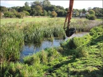
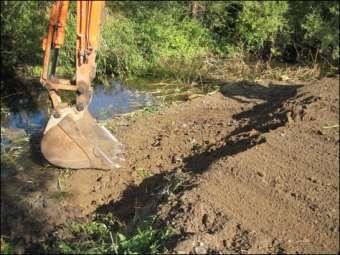
Layham: Berm Construction 1. 7 October 2014


3. Bank re-graded to provide infill material. 4. Completed berm
4. Completed berm. Narrows channel at low flows and drowns out at higher flows.

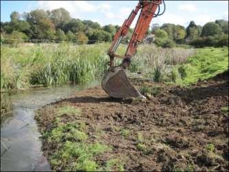
Layham: Berm Construction 2. 7 October 2014


1. Outer edge formed from bed material. 2. Infilled using spoil from river bank.
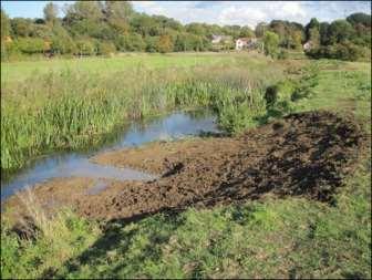
3. Final re-profiling to form berm above summer water level and gently shelving bank angle.
Shelley Berm Installation 1
1. Existing steep bank on inside of bend. 2. Outside edge of berm shaped with locally sourced timber secured by stakes
3. Bank pushed in to infill behind timber edging 4. Berm height adjusted to be above summer water level


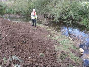
5. Completed berm with gently shelving bank profile
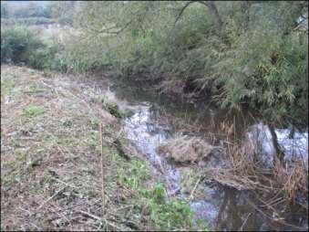
Shelley Berm Installation 2

Pre-works: Straight, wide channel with steep banks

Post-works: channel narrowed and sinuosity increased through installation of berm. Bank regraded to give gentler slope.
Invasive species alert—Quagga Mussel >
Please look out for this species in Suffolk. The first record was in October 2014 when Environment Agency ecologists found a population in a tributary of the River Colne in the Thames catchment near Staines.


