3 minute read
Around the Reef


By Mary Dillard Communications Volunteer and Staff Gray’s Reef National Marine Sanctuary
In addition to being a great spot for recreational fishing and diving, Gray's Reef National Marine Sanctuary also serves as a living laboratory for marine scientists. Last month I had the pleasure of speaking to Alison Soss, a geospatial analyst at the sanctuary. In layman’s terms, a geospatial analyst takes data collected in the field and displays it on maps, helping to guide current and future scientific research. Currently, much of Soss' time is spent supporting the sanctuary's acoustic telemetry project, which tracks the movements of marine animals, and its soundscape project, which record sounds in the ocean.
Advertisement
“We really don't know much about the ocean's soundscape ... we also don't know all the fish species that are out at Gray's Reef,” Soss said.
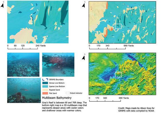
Several different sources are used to create maps. For example, during the 2011 Nancy Foster Expedition in Gray's Reef, technicians aboard the NOAA Ship Nancy Foster used the ship's multibeam echosounder to record changes in depths of the ocean floor, which provided heights of various ledges at the reef. Then scientific divers dove to some of the higher ledges to characterize different types of habitats in the sanctuary. Some habitats are densely colonized by sponges, corals and tunicates; other areas are flat and sandy; and some are “hotspots” that attract lots of sea turtles, fish and sharks. Together, the multibeam data and the habitat characterizations act as the sanctuary's base map for planning research to better understand the ocean, the reef, and the animals that live in and visit Gray's Reef.
Soss also is responsible for maintaining the scientific equipment used underwater. The current at Gray's Reef is strong and swift, and shifting sands can move the hydrophones and receivers. Some of Soss' maps illustrate where the equipment is deployed, and in a few cases, pinpoint where various pieces of equipment have moved. Every few months, Soss and a team of scientific divers retrieve the recorded data so that sanctuary staff and research partners can process and analyze the information. The data yields a wellspring of information. More than a dozen animal species tagged outside of Gray's Reef have been detected in the sanctuary, including the endangered Atlantic sturgeon and a variety of sharks. Soss says the baseline data also helps scientists catalogue specific sounds that animals make, so that changes in the sanctuary's soundscape can be recorded over time.
Although research is her greatest love, Soss also gives presentations to grade schoolers and college students, collaborates on research reports, and summarizes data for NOAA and fellow researchers. She has begun creating maps for the general public, as well.
“I want everybody to be able to understand what we are doing here at Gray's Reef National Marine Sanctuary, and it might be as simple as showing them a map.”
She does say, however, that making maps can go beyond what one might imagine. “I'm learning that cartography is an art within itself. How information is displayed on a map can guide the narrative and interpretation of the data you're using.” Soss works hard to make scientific data as appealing and understandable to as many people as possible. Her passion and enthusiasm to bring Gray’s Reef to those of us on land are unmistakable!
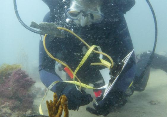
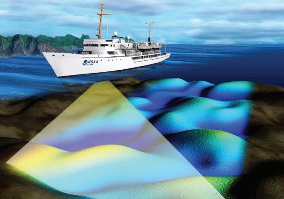
Above: Alison Soss measuring the Gray's Reef habitat in 2019. Photo by Kimberly Roberson, NOAA Below: Illustration of a NOAA ship conducting multibeam bathymetry. Image created by NOAA Bottom: Tall ledge habitat characterization and multibeam map of Gray's Reef National Marine Sanctuary with data compiled by NOAA. Map by Alison Soss, GRNMS For Information contact Michelle Riley: (912) 598-2417 michelle.riley@noaa.gov